This is the third of the supplemental articles for
the Kim
Jong-un's First Decade in Power series. It details the various infrastructure changes and weapon developments of North Korea's conventional forces over the last decade.
As I recently laid out in Sharpening
the Treasured Sword, there’s plenty to talk about when it comes to the
nuclear issue and there’s no shortage of analysts and think tanks who provide valuable
information on the topic. What often gets overlooked, however, is how North
Korea’s conventional military has changed over the years, particularly regarding
training, and how the parallel national economy operated by the military has
altered the literal landscape of defense infrastructure.
The US Defense Intelligence Agency’s 2021 North Korea
Military Power report
noted,
Kim Jong Un has also
focused his attention on the KPA’s conventional capabilities. From 2011-2017 Kim kept up a steady pace of
public engagements with military units to emphasize the KPA’s centrality to the
North Korean regime, and has directed improvements in the realism and
complexity of military training. To that
end, Kim presided over high-profile artillery firepower exercises, Air Force
pilot competitions, and special forces raid training on mock-ups of the South
Korean presidential residence.
Using the locations mapped in the AccessDPRK
2021 Pro Map, I want to examine the evidence of on-the-ground changes and what
adaptations have occurred under Kim Jong-un to the country’s conventional
forces, and how these changes have positioned the North Korean armed forces to
take greater advantage of their limited technology and supplies so they still
pose a credible threat in spite of such limitations.
Within the AccessDPRK map are over 13,000 military-related
sites. However, a single missile or navy base could include a dozen other sites
as individual locations of interest within those bases are identified. Thus,
the focus of this supplemental report will be on the primary aspects of North
Korea’s military infrastructure: individual bases as a whole, major artillery
sites, the KPA Navy, and KPA Air Force. So, this brought the scope of research
down to around 5,000 relevant locations.
As they’re associated with the nuclear issue, the country’s missile
bases are excluded from this report as are the numerous static
fortifications throughout the country. While static fortifications may have a
role to play in delaying an invasion, and though some
sites have been constructed by Kim Jong-un, they are not part of North
Korea’s offensive capabilities nor would they play any sort of active
role during a conflict in the same way a radar site or airbase would.
I’m also not going to include airfields that were
constructed or modernized for VIP use. Sites like the Sanghung-dong
VIP Helibase or palace
runways tell a story in their own right, but I don’t feel they belong in
the scope of this report.
KPA Bases

In the process of mapping the country, which I began in late
2012, two main trends became obvious. One, that there was some sort of overall
restructuring taking place. And, secondly, that there was a huge emphasis being
placed on military training.
Although these changes began years prior, it was at the
Seventh Central Military Commission meeting in 2019 that the KNCA reported on
major reforms within the military. Particularly, the government wanted to
address “irrational structure and defects in machinery and some shortcomings
in other military [activities]” and the meeting discussed the “decisive
improvement of the overall national defence and core matters for the sustained
and accelerated development of military capability for self-defence.”
The reference to “machinery” wasn’t talking about industrial
machines but was referring to the military bureaucracy and how the military
carries out its goals, from training and readiness to utilizing personnel.
The Seventh Central Military Commission thereby served to
openly codify what had already
been happening on the ground for some time.
Based on the AccessDPRK 2021 Pro Map, there have been at
least 127 bases that were either newly constructed or underwent a major
renovation since 2012 (with heightened activity from 2014-2017). And,
reflecting North Korea’s military strategy, most of the new construction has
been at sites within 100 km of the DMZ, which is where roughly half of all KPA
personnel is stationed.
Among these facilities are over 50 training bases of various
types. Ranging from small collections of obstacle courses and firing ranges to
large tank training fields and urban warfare centers, it is clear that the
organizational system for training has been reformed and as part of that, that
the bases themselves underwent a period of renovation to better provide the
types of training the regime deems necessary.
A few examples can be found at the following sites.
- In 2014, the large training complex near Yongbyon (39.850105° 125.675129°) was modernized and an urban warfare center (or MOUT = military operations on urban terrain) was added that includes a mockup of the headquarters building of the ROK combined forces complex in Gyeryongdae.
- Soe-gol, the largest single training base in Pyongyang, had a vast driving course added in 2019 that has 11 km of paths and multiple obstacle sites (berms, water obstacles, etc). Other portions of the base have also been renovated or expanded over the decade.
- An example of a more traditional training complex can be found at 38.422863° 128.102209°. It was established in 2016 and contains an obstacle course with hurdles, ditches, a trench, and a 100-meter-long pool.
- Lastly, a 1.5 sq. km. complex near the Ryokpo Leadership Residence (38.895717° 125.940640°) was completely reconstructed from 2014-15 and includes multiple distinct training areas. While the exact identification of the complex is unknown to me, its layout and building designs suggest that it includes ideological training beyond what is normally provided and is used by elite military units.
As the US Defense Intelligence Agency's military power report
also noted, “North Korea has emphasized SOF unit training with particular
focus on improving their capability to raid key government installations in the
South.”
As part of that, North Korea constructed scale-models of
South Korea’s Blue House, the DMZ Joint Security Area (Panmunjom), and the
aforementioned Gyeryongdae model.
The Blue House is of particular interest because in 1968
thirty-one North Korean agents infiltrated the grounds of the Blue House in an
attempt to assassinate South Korean president Park Chung-hee. The model was
constructed in 2016 and “raids” have been carried out at least twice, with
paratroopers and other special forces attacking the building.
No large-scale attack exercises are known to have taken
place at either the mock Panmunjom or Gyeryongdae sites but both structures are
located at large training bases and provide the KPA with opportunities to
familiarize themselves with the locations and how to attack them. However,
Panmunjom offers more than just war training.
The timing of its construction
in late 2017, while not built for the summit no one knew would happen, could
have given Kim Jong-un and particularly his security guards the ability to do
dry runs, walking through the complex and knowing how and where to move. It may
even now serve to train the border guards in the region on how to stop any
future defections after the bold escape of Oh
Chong-song on Nov. 13, 2017.
While these mockups could be categorized as part of MOUT
training, the largest MOUT base in the country is at Unsal (40.013806°
125.885916°), with the ‘urban’ section of the base covering 16 hectares. The
actual MOUT structures have largely remained the same, but the other facilities
at the base were expanded in two phases between 2014 and 2020, with the administrative
center receiving the most change. As I’ll discuss in some more detail later, a
paratrooper jump tower was also erected at the base in 2014.
The large Changdo training complex (38.642975° 127.742591°) includes
a MOUT sector that was constructed in 2018-19 as well as a large firing range
and areas for tank maneuvers. In 2011 and 2018 a series of 31 new barracks were
constructed, allowing at least 1,500 soldiers to train at the base at any given
time.
Of the seven largest MOUT facilities, five have experienced
some level of renovation or expansion and a sixth may currently be having
relevant construction done.
Lastly, dozens of ‘drive-thru’ bunkers have also been constructed in recent years. These bunkers are able to accommodate trucks, armored vehicles, and towed artillery but not TELs. The bunkers vary in size but tend to be 5-6 meters wide and 20-40 meters long. They can be used to protect vehicles during fueling or adding armaments and also provide hardened cover to allow them to fire at a target and then hide to evade detection and counterfire, the so-called shoot-and-scoot tactic.
Artillery

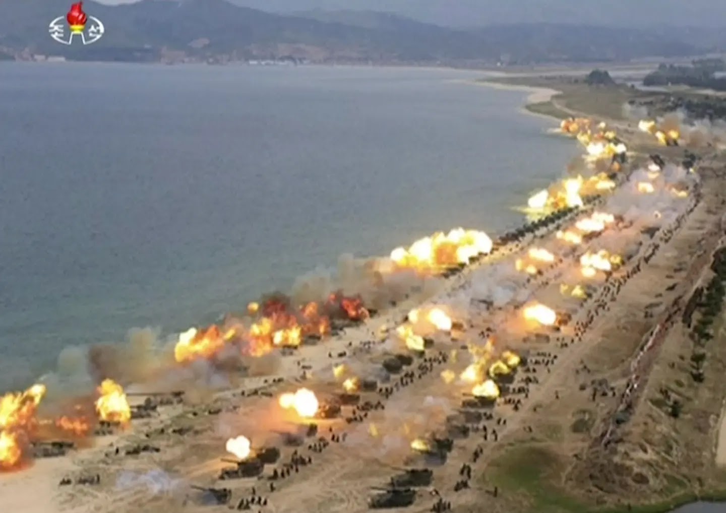
One of the earliest changes that Kim Jong-un saw through was the construction of 126 hardened artillery sites (HARTS). Nearly all of them were built within 10 km of the DMZ.
Construction work on this massive project began soon before
Kim Jong-il’s death, but Kim Jong-un continued the work which extended into
2017. These new HARTS comprise 20.7% of all HARTS in the region and hold
between four and six individual guns (the Koksan 170 mm self-propelled gun, and
122 mm, 130 mm, and 152 mm systems are all capable of being used at these
sites). The new HARTS can fire artillery 60 km, placing all of Seoul and Inchon
in range of tens of thousands of artillery shells an hour.
A number of individual hardened bunkers for multiple rocket
launchers were constructed as part of this broader project along the coast of
South Hwanghae Province, placing islands near the Northern Limit Line at risk.
Most of these MRL bunkers were constructed in 2012 after the 2010 shelling of Yeonpyeong
Island, with several more built in 2014. It has been reported
that Kim Jong-un visited one of the bases from where the shelling originated
the day before the attack.
Despite their near obsolescence in the face of modern
fighter jets, North Korea has also continued to update its air defenses and
to reassess which anti-aircraft artillery (AAA) batteries are still necessary
and which ones can be decommissioned.
In the last decade, 19 AAA batteries have been constructed. Additionally,
there are two likely surface-to-air missile (SAM) sites currently under
construction which, once completed, would bring the total number of active
sites to 61. The new SAMs would be capable of supporting North Korea’s newest
SAM system, the KN-06 and variants.
While North Korea’s AAA batteries field predominately
low-altitude, Soviet-based artillery that can’t threaten most modern fighter
craft or bombers, the country has nonetheless constructed 19 new batteries.
The construction of these new sites often coincided with the
decommissioning of a number of others, particularly in eastern Pyongyang in
2016-17. And over the last 35 years or so, there have been around 300 total
closures of AAA sites across the country. The reasons for removing an AAA site
in 1986 or in 2016 could easily be the same given the state of the country’s
artillery. Most of the guns are from the 1950s and 60s, there is a lack of
ammunition and a lack of replacement parts for the older radar systems.
So, closing redundant sites, especially in the face of
modern warfare, makes sense to preserve their limited supply of parts for more
important sites. However, the fact at least 19 have been built in just the last
decade raises some questions about this commonly held wisdom.
However, what’s more important than adding a few or
demolishing a few AAAs has been the development of new radars, new
surface-to-air missiles, and other air defenses.
But before I move on to these newer systems, a number of
older AAAs have been converted to hardened sites, with the guns hidden within
bunkers instead of out in the open or covered by tarps. Additionally, several
other sites have had their radars replaced and other features added that may
make them capable of being launching sites for rockets and short-range
missiles.
As for North Korea’s surface-to-air missile (SAM) systems,
while most of the soon-to-be 61 active sites still rely on S-75, S-125, and S-200 systems from decades
ago, the country does have the ability to maintain and replace them and they’ve
been kept at a higher state of readiness than the shorter range AAAs.
But beginning in 2017, the country started to field its own
KN-06 SAM system (largely based on the Russian S-300). Its use of mobile radar
instead of the usual fixed emplacements also means that the systems could be
deployed at any number of hardened sites and not just at the existing 61 known
SAM sites. According to The
Drive, the KN-06 radar system “appears to be an indigenous version
of the mobile 5N63 "Flap Lid" phased array radar, and likely has
capabilities somewhat akin to later versions of the S-300P SAM system…[these]
later versions could track 12 and engage six.”
Continuing with air defense, North Korea recently tested
a new anti-aircraft missile, with the test “aimed at confirming the
practical functionality of the missile's launcher, radar, comprehensive battle
command vehicle and combat performance.” More information is still needed
but if the test was indeed successful and the missile goes into mass
production, it adds another layer of complexity to any future air war over the
peninsula.
Lastly, North Korea has tested several new types of multiple
rocket launchers including a ‘super-large' MRL (known as the KN-25) in 2019 that
has a range of 321
km. Blurring the line between rockets and short-range ballistic missiles, if
deployed in sufficient numbers along the DMZ, they could target roughly 90% of
South Korean territory and could easily threaten every American base in the
country except for the U.S Navy base at Jinhae.
KPA Navy

There were a number of early signs that the KPA Navy was
attempting a modernization program (encompassing new weapons and new
infrastructure), with Kim Jong-un continuing a number of programs initiated by
his father and beginning some of his own.
Outside of the development of submarine-launched ballistic
missiles and the Sinpo-C submarine variant (which was discussed in Sharpening
the Treasured Sword), North Korea began to show off its latest Nongo
class surface effect ships (SES). In development since at least
2002, the first official images of these SES with all of their armaments in
place occurred in 2015.
They have been described
by ArsTechnica as “a high-speed "stealth" ship-killer
using a surface effect hull—a combination of catamaran and hovercraft.” The
“stealth” comes from a faceted hull shape that lowers its radar reflectivity.
While not a true stealth ship, it is an improvement over older vessel designs.
These SES carry four KN-09 anti-ship missiles batteries. According
to ArsTechnica, they also carry two AK-630 30mm close-in weapons
systems, four machine gun turrets, and a short-range anti-aircraft missile
system. Nongo’s have been spotting in Wonsan, Munchon, and Nampo and at
least five of them have been identified as of 2021.
The Navy also developed two new frigates capable of carrying
helicopters, first launched in 2011-12. According to Joseph
Bermudez, these anti-submarine warfare helicopter
frigates (FFH) are the largest KPN surface ships developed since 1990 and “may
also represent an evolutionary step in the development of naval strategy to
include helicopter anti-submarine operations.”
Beginning around 2013, one of the two Najin-class
frigates (North Korea’s flagship class) started to undergo a modernization
process of its own. The vessel, hull number 631, had several systems replaced
throughout 2014 and new ones added including
two 30mm automated turrets (based on the Soviet AK-630 CIWS) and eight Kh-35 anti-ship
missiles. Other short-range missile systems and newer radars were installed
later. This makes the ship the most dangerous traditional warship in the fleet.
The ingenuity of North Korea’s Navy can be summed up in this
quote by H. I.
Sutton of Covert Shores, “It is a myth that North Korean naval vessels are
by definition clones of older Russia or Chinese designs. In fact North Korean
naval architects have produced a long string of original designs, often with
novel features. They have Semi-Submersibles, catamarans, Surface Effect Ships
(SES) and now they have Very Slender Vessels (VSVs).”
VSVs are high-speed, wave-piercing craft. Their
wave-piercing nature enables the craft to punch through the waves (instead of
riding over them, being buffeted with each one), increasing speed and lowering
the physical stresses on the crew in heavier seas. Their design also gives the
hull a smaller radar cross-section, although poor weapon layouts and other
equipment can negate this benefit.
According to Sutton, North Korea has multiple VSV types
ranging from 10 m in length to 32 m and there are at least seven individual
craft in their inventory. The first VSV was spotted on Google Earth in 2012 and
they are currently stationed at Chongjin, Nampo, and Wonsan.
How the regime plans to utilize this new platform isn’t
known, but they are likely to be used as interceptors, patrolling the country’s
important fisheries (as implied by their location in Chongjin) and also used to
conduct raids into South Korean waters.
Some existing older ships have also begun to be outfitted
with more modern radar systems, anti-ship missiles, close-in weapons, and torpedoes.
To facilitate the construction, berthing, and continued
maintenance of these new (or improved) ships, a number of naval facilities have
also undergone their own modernization program.
One of the construction halls at Nampo was elongated in 2018
and a smaller manufacturing site nearby (38.730751° 125.423457°) underwent
considerable renovations and new construction in 2013-14, 2016, and in 2021.
The area north of Munchon is home to the 13th
Naval Command which is a collection of at least nineteen units (dispersed in
and around Kumya Bay and the Songjon Peninsula) including KPA Navy units 155,
597, and 291. It is home to squadrons of patrol boats, torpedo boats, and
hovercraft (at five distinct sites).
The first instances of change here occurred in 2013 when
several small barrack buildings were constructed. Work began to speed up in
2015 with numerous older facilities demolished and a large artificial port yard
was constructed for Unit 291 through land reclamation, adding over 127,000 sq.
m. of land and resurfacing a further 27 hectares around the village of
Tapchon-ri.
Additional work was carried out at Unit 597 (39.317336°
127.401134°), a major maintenance and repair yard. Nearly the entire complex
was reconstructed between 2015 and 2016 and new buildings were also added.
A one-kilometer road and rail bridge was also constructed from
2015 and 2018, connecting units 291 and 597, better integrating a naval complex
that extends for several kilometers across bays and islands.
However, after the initial foundation work and land
reclamation at Unit 291 (39.333230° 127.431410°), progress slowed tremendously.
Currently, a few foundations have been prepared and 15 piers are under various
stages of construction but there has been little substantial work since around
2018.
It was suspected
that the work at Unit 291 was to create an east coast HQ for the Navy’s amphibious
assault command and its numerous hovercrafts.
This stalled activity is not the only example to be found at
a hovercraft facility.
There are several hovercraft bases on both coasts and the
country’s fleet is around 130 Kongbang-class hovercraft. These
hovercraft are stationed across ten locations with the largest concentration
being in six sites in Wonsan Bay (five as part of the Muchon base and one
other, north across the bay at Je-do Island).
Despite these existing facilities, Kim Jong-un began
constructing three new hovercraft bases, one at San-gol-li in Kangwon and two
in South Hwanghae Province at Manghae-dong and Yonbong-ni.
Together, these bases would be able to station at least 90 craft and would cut
transit time into South Korean waters by half, and could transport over 3,600 troops
every few hours. Construction at the largest of these bases, Yongbong-ni began
in 2015, followed by San-gol-li in 2016, and Manghae-dong around 2017.
Curiously, after some initial construction work, San-gol-li
was abandoned. And then, after continual
progress for multiple years, work at Yongbong-ni was likewise halted. Work
at the nearby Monghae-dong also came to an end. Currently, all three sites seem
to have been abandoned.
The reason(s) for the decision to stop construction work at
these three new sites as well as the stalled work at Munchon seems
inexplicable, particularly as the primary reasons for constructing them in the
first place still remain pertinent. The existing bases are still well
maintained and landing exercises are conducted every year, often under the
watchful eye of Kim Jong-un, but it seems that the military’s focus has been
drawn elsewhere for the time being.
Another major addition to naval infrastructure was the
construction of a new submarine training center at Sinpo. The demolition of
older structures began in 2009 but the new facility’s construction has taken
all of Kim Jong-un’s rule to-date to complete, with the construction of the new
buildings primarily happening after 2015. A decade in the making, this facility
is suspected to replace a smaller training site at Mayang Island.
The center has two training pools with an escape tower, an
academy building, and several apartment buildings for students and staff. The
Sinpo facility will be the second of two primary submariner training sites, the
other being at Pipa-got naval base on the west coast.
As Dave Schmerler wrote,
“With this new site nearing completion, and the release of images showing
what is likely to be North Korea’s first deployable ballistic missile
submarine, their intentions on expanding their submarine fleet’s capability on
their east coast has become much more transparent.”
The development of the Nongo-class SES, the
anti-submarine warfare helicopter frigates, and the Najin modernization
program have led to a reconsideration of North Korea’s maritime capabilities.
While it is still not a blue-water navy, the threat it poses to South Korean
ships and its ability to attack both enemy submarines and surface vessels
within their territorial waters has improved dramatically compared to the KPA
Navy of Kim Jong-Il’s era.
KPA Air Force
Despite North Korea’s “newest” aircraft being variations of
Soviet and Chinese models from the 1970s, Kim Jong-un has nonetheless placed greater
importance on the air force than Kim Jong-il, particularly when it comes to
training the country’s special airborne forces, developing aerial weapon systems that can be indigenously
produced (if not new fighter jets), and he also has taken steps to help improve
the survivability of aircraft in the event of a crash or other emergency.

The AccessDPRK database has 30 identified highway strips. These are straight, level stretches of road (sometimes paved, sometimes not) that can be used as an emergency runway for any number of reasons. Some are geared toward use by small An-2 biplanes and others can accommodate fighter jets.
These highway strips are nothing new to North Korea, but Kim
Jong-un decided to make them more useful by adding parking revetments to 29 of
them. These revetments are protected by earthen berms and are typically located
a hundred or so meters away from the highway to allow the road to still be used
as a runway while the other aircraft are being parked.
I have identified a total of 71 individual revetments.
Depending on the type of aircraft, these can accommodate anywhere from 142 to
213 aircraft combined. The main period of revetment construction occurred in
2016-17.
Two grass landing strips also had revetments added and a new
landing strip was constructed near Chongjin in 2016 (41.802706° 129.854602°).
As part of the attempt to improve the survivability of
aircraft during an overshoot or crash (poor maintenance and a lack of spare
parts in the air force is a notorious problem), 19 major airbases had
“arrester beds” constructed
between 2015 and 2016.
In other countries, these beds are made up of “engineered
materials”, often special concrete pads that are lightweight and can crush
easily, absorbing energy and slowing down the aircraft. But in North Korea,
they appear to be made up of sand beds. Though more effective than nothing,
their installation highlights the struggle of trying to provide better safety
while lacking the capacity to do so in substantive technical ways.
As with infantry training, the training of paratroopers and
airborne special operations forces has been substantially increased. North
Korea currently
has ten parachute jump towers (which are used to train recruits how to use a
parachute from various heights as part of their basic training before jumping
from an aircraft), of those, four were constructed under Kim Jong-un with a
further two being renovated.
Two of the new towers, in Pyongsan and Unsal, were
constructed within large urban warfare training centers which underscores North
Korea’s primary offensive strategy, that is to rely on special operations activities
to disrupt South Korean military movements and slow any US counterattack by
sending waves of soldiers behind enemy lines.
A third tower was constructed at the Changdo training
complex in 2014. As noted in the KPA Army section, this base is capable of
training at least 1,500 soldiers at any given time and provides a wide range of
training exercises. The tower was built several months after the base itself
underwent a major renovation.
The fourth tower built under Kim is at a remote site near
Sonchon (39.823569° 124.918211°). The steel lattice tower was erected sometime
between 2014 and 2017 and is a small, stand-alone training site that isn’t part
of any larger complex.
A number of additions and renovations have also been noted
at the Panghyon Aircraft Plant which is North Korea’s most important aircraft
manufacturing center.
And, wrapping up the infrastructure changes, even the KPA
Air Force’s headquarters
in Chunghwa (38.868645° 125.804992°) has seen some substantial additions over
the years. From the ‘Air Defense and Combat Command’, over 110,000 personnel,
1,700 aircraft, and 37 key bases (along with many smaller ones) are overseen.
The first noted change under Kim Jong-un was the
construction of a new gym from 2012-13 as well as a possible ‘revolutionary
history’ museum. Then in 2016 the northern end of the base saw substantial
construction activity with three multi-floor dorms, an assembly hall, and
another large building all being added. Another unidentified building was
constructed at the same time in the center of the base.
Kim has repeatedly called for the “scientific and strategic
enhancement” of the air force. In the absence of new fighter jets, bombers,
modern avionics, or the ability to acquire those things, this has been taken to mean
that the air force needs to develop ways to deliver nuclear weapons and to come
up with other weapon systems that can be produced within the country.
To ensure a greater warfighting capacity, Kim has begun to outfit
his fleet of 300 An-2 biplanes (which would be used to fly low, evading radar,
and deploy paratroopers and supplies behind the front lines) with satellite
navigation aids and even air-to-surface munitions.
As conflict specialist Sebastien Roblin wrote,
“Surging dozens or hundreds of difficult-to-detect An-2s could easily
overwhelm the air defenses on the DMZ”. To further assist in making them
difficult to detect, the color scheme of the An-2s was changed in 2014 to
lighter colors and countershaded, making them visually blend into the sky or
ground, depending on the adversary’s perspective.
Although North Korea can domestically produce much of what
the Army and Special Rocket Forces now require, their ability to develop and
produce new aircraft has been a major shortfall in their capabilities. In the
absence of new generations of aircraft, North Korea will have to rely on
upgrading its fleet with improved sensors and electronic warfare systems as
well as building up a fleet of unmanned aerial vehicles to do everything from reconnaissance
to conducting kamikaze attacks.
There is only limited information about North Korea’s
development of new electronics, but there is plenty of evidence they are taking
drone warfare seriously.
The potential value of drones as force multipliers and
providing targeting data has been demonstrated in Syria, the recent Nagorno-Karabakh
conflict, and by terror groups such as ISIS and the Houthis in Yemen. The asymmetric
nature of drone warfare and their low cost also fits well
within North Korea’s military doctrine.
In support of their UAV goals, there is a facility at 39.128763°
125.471549° (on the Tokjwa Reservoir) that appears to be a UAV testing base. It
was first noted by Nathan J. Hunt last year. The site was constructed in 2019
and includes a short runway, less than 100 meters long, a hangar, and either a
previously unseen UAV model or a scale model of another type of aircraft.
Further base construction also began this year. If this is a UAV base, it would
be the only stand-alone drone development facility known in the public domain,
that is, that wasn’t part of a factory or airbase.
Several North Korean reconnaissance drones have been spotted
in South Korean territory, particularly since 2014, and the government has
discussed the need to mass
produce UAVs on more than one occasion. Current estimates for North Korea’s
UAV inventory vary considerably but fall between 300 and 1,000 drones.
Growing Your Own
One other area that I would like to talk about is the
military’s requirement to grow as much food for itself as possible.
This requirement was ordered by Kim Jong-il as a result of
the famine, but ongoing food shortages has meant that the state still cannot
provide enough rations to feed its own soldiers. Stories of soldiers going out
and stealing from civilians still pop up, so it’s little wonder that the very
look of many bases and even industrial sites has changed.
Much of this change can be charted through the last decade.
Despite genuine improvements in the country’s food security under Kim Jong-un,
the military still needs to grow its own food and is also required to grow
specialty crops that can be sold to external markets to earn foreign currency
for the regime.
KPA owned farms can be massive, like KPA
Farm No. 1116 which has 368 hectares under cultivation. The farm also grows
mushrooms that are sold abroad, earning money for the state. Underscoring the importance
of this military farm, Kim Jong-un has visited it nearly every year since 2013.
But it's not just military-controlled, agricultural-specific
sites that are involved in the farming business.
The nuclear test site at Punggye-ri extends for 17 km down
the Namdae River valley. In multiple places, small farms can be seen comprising
dozens of hectares under cultivation to support the needs of Punggye-ri’s
personnel. This activity has continued despite the complex being “closed”.
The former high explosives test site at Yongbyon was
converted into a garden in 2003 and a series of greenhouses were added nearby
in 2013. Additional greenhouses and cultivated fields can be spotted throughout
the walled compounds within Yongbyon, including greenhouses built in 2014
within the Radiochemistry Laboratory where spent fuel rods are reprocessed.
As for North Korea’s current high explosives test site at
Yongdeok (40.002399° 125.339812°), a well-defined garden was added in 2019 and
occupies 18,300 sq. m. Facilities at Yongdeok’s fish farm have also been
improved in recent years.
These gardens and fields can be found at most KPA bases and
even at air defense sites like surface-to-air missile batteries. Some examples
of this can be seen at the Majon-ri base (39.122529° 127.128347°) in Kangwon
Province where the housing units each have small garden plots while other parts
of the base contain collective farms. And at this (38.406613° 127.359467°)
unnamed base near the DMZ, a greenhouse was built in 2019/20 next to the munitions
depot.
It’s not only things like rice or mushrooms that are being
grown. Military-owned livestock facilities, fisheries and fish farms have
proliferated. One of the largest is the Singchang Fish Farm which breeds
sturgeon. It is operated by KPA Unit 810, the same unit that operates KPA Farm
No. 1116 in Pyongyang. Kim Jong-un has visited the site multiple times and in
2019 several of the ponds were extensively modified.
Inland fish farming is but one part of a large KPA fishing
industry that also involves the military owning fleets of small fishing
vessels. As discussed in the 2020 report
Fish, Fishing and Community in North Korea and Neighbours, “In recent
years, the fishing infrastructures and desires of North Korea’s central
government have picked up again, and fishing has been reorganised into the
institutional frameworks of the Korean People’s Army.”
Sadly, some of these vessels end up as “ghost
ships” wandering into Japanese waters with a dead or missing crew.
Under Kim Jong-un, fields have become more organized,
greenhouses have been added to improve yields and diversify the types of plants
that can be grown, and attempts to earn illicit currency through
military-controlled trade networks have continued.
Conclusions
In short, Kim has been trying to make the most of a bad
situation.
The obstacles are enormous, from problems with the fitness
of its manpower pool to a lack of modern technology and an inability to
manufacture certain equipment and parts domestically, Kim has therefore been
forced to redirect resources toward enhancing special operations forces
training, building a better capacity to infiltrate targets and to engage in
non-kinetic warfare through cyber (something not covered in this report), as
well as attempt to improve the survivability of KPA forces via safety measures
at airfields and constructing hardened facilities.
Although nuclear weapons guarantee regime survival, their
use would also guarantee its end. To that end, North Korea needs a credible
conventional deterrent as well to show that the price of even minor military
action against Pyongyang could still result in overwhelming casualties, even if
a nuclear bomb is never dropped.
Naturally, questions surround the ability of DPRK armed
forces to adequately train its forces, particularly in the use of newer weapons
that have been developed (such as semi-automatic grenade launchers, tank
destroyers, and various multiple rocket launchers). As Liang Tuang Nah pointed
out in The
Diplomat, the bulk of training that gets shown to the world through
official media consists of troops and equipment engaged in mass-firing
exercises and air shows that look more like a performance than integrated
training among the various branches or in ways applicable to real-world combat
in the 21st century.
However, the country isn’t spending 25-30% of its GDP just
on nuclear weapons and shooting off ancient ammunition. The massive build-up of
training facilities includes opportunities for individual units to learn tank
warfare, fire any number of artillery and rocket systems, and improve each
individual soldier’s skill.
The hills of North Korea are pockmarked with chalk targets
for aerial bombardment and ground-based artillery. Even whole islands have been
designated for artillery practice. Although it is not possible to monitor all
of the activities that occur by using commercial satellite imagery and while
changes to doctrine, strategy, and interservice cooperation can only be
glimpsed at through Pyongyang’s publications, the physical evidence is still
there to inform us. And it’s telling us that Kim Jong-un has not created a
paper tiger.
New weapons, improved training, and creative ways to finance
North Korea’s conventional forces have created a qualitatively better armed
service than in years past. Clearly, military parity with South Korea is a pipe
dream on the technological front, but an army doesn’t have to be equal on paper
to pose a real threat on the field. And even North Korea’s alleged inability to
wage a long-term (6 months+) full-scale conflict due to a lack of fuel, food,
and parts, drug lords in Mexico to terrorists in Afghanistan have shown that a
prolonged conflict can be still carried out in the face of overwhelming odds.
Indeed, the Syrian Civil War and the recent 2020 Nagorno-Karabakh
conflict have demonstrated that through the use of non-traditional strategies, electronic
warfare, and through the targeted use of UAVs, that strategically significant
actions can be effected.
By focusing on special operations, asymmetric capabilities,
and cyber operations, Kim Jong-un is working to level the playing field. Again,
the goal is not the KPA facing down South Korea in 20th century-style
set-piece battles. The best-case goal is to deter and if that doesn’t work, to
inflict as much damage as possible while prolonging the conflict until a set of
key goals are accomplished (namely the capture of Seoul and delaying a US counterattack)
so that a new “peace” can be settled on terms favorable to Pyongyang.
Kim is still a long, long way off, but the military
(particularly the Army) is nonetheless better positioned now than it has been
in a decade, both in terms of real power and in its ability to leverage threats
to gain economic and political benefits.
~ ~ ~ ~
I have scheduled this
project to run through to the end of the year, with a new article coming
out roughly every 10 days or so. If you would like to support the project and
help me with research costs, please consider supporting AccessDPRK on Patreon. Those
supporters donating $15 or more each month will be entitled to a final PDF
version of all the articles together that will also have additional information
included once the series is finished. They will also receive a Google Earth map
related to the events in the series, and can get access to the underlying data
behind the supplemental reports.
Supporters at other levels will be sent each new article a
day before it’s published and will also receive a mention as seen below.
I would like to thank my current Patreon supporters: Amanda O., GreatPoppo, Joel Parish, John Pike, Kbechs87, Rinmanah, Russ Johnson, and ZS.
--Jacob Bogle, 10/31/2021
AccessDPRK.com
JacobBogle.com
Facebook.com/accessdprk
Twitter.com/JacobBogle


.jpg)