Ever since Kim Jong Un came to power, North Korea's aviation infrastructure has undergone a series of changes, making it difficult to keep an up-to-date record of what airports and landing strips exist and where.
For this article, I want to review more recent changes and provide an update to the last AccessDPRK post that focused on the country's air force back in 2018.
Starting in 2014 Kim constructed several small new runways at his favorite palaces, then he went about improving the country's emergency landing strips. Before that, he oversaw the modernization of Pyongyang International Airport and then majorly expanded the Kalma Airport in Wonsan.
In recent years, however, the trend has reversed. Eight airports have been razed and another converted to other uses (at least for the time being).
Two of the palace runways were removed and replaced with horse riding tracks - Sinchon Palace Runway (built in 2015, replaced in 2019) and Wonsan Palace Runway (built in 2014, replaced in 2019). These horse riding tracks are for Kim Jong Un and his closest allies to use, but a number of recreational and military horse tracks have also been established elsewhere around the country.
A third palace runway, at Myohyangsan (40.028515° 126.193115°), was demolished in 2021.
The Pyongyang VIP Heliport (39.049587° 125.805278°), built in 2015, is also now being removed and a new complex of buildings is being constructed in its place. The full purpose of the building complex isn't yet known.
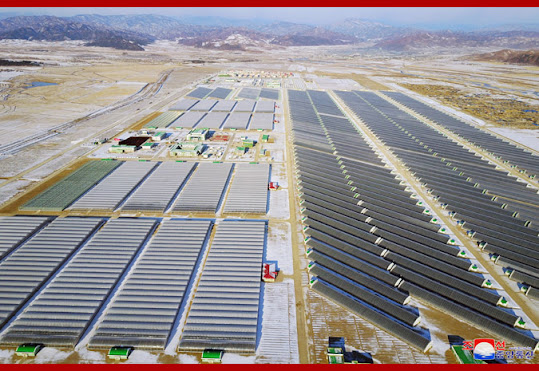
Then there are the two airbases that have been demolished and replaced with large vegetable farms and greenhouses - Kyongsong Airbase (41.558215° 129.629752°) was demolished in 2018 and the Yonpo Airbase (39.790289° 127.535685°) was demolished in 2022. This has been the largest transfer of military property to the civilian sector that I am aware of, affecting slightly over 5 sq. km.
Although the Kyongsong Airbase was demolished for the vegetable farm (named Jungphyong after a nearby village), the associated air force officer training school still exists (41.577780° 129.634636°).
COVID-19 has also impacted the availability of airbases to the North Korean air force. The Uiju Airbase, near Sinuiju on the border with China, was shut down in 2021 and some of its aircraft transferred to other sites. Then Uiju was fenced off and turned into a massive decontamination facility for goods coming into the country from China.
Unlike Kyongsong and Yonpo, the runway and other facilities at Uiju still remain and it could be reconverted into an active airbase at any time.
Kumgang, a county in Kangwon Province and where the Mount Kumgang Tourist Region is located, only had a small dirt runway that was routinely damaged by floods. In 2011-2012, to the north of town, a new kilometer-long paved runway was constructed, complete with aircraft parking revetments, service buildings, fuel storage, and hardened bunkers. It also goes by the name of Onjongdong-ni Airfield.
Yet, in the imagery available, there's no clear evidence that the runway was ever used and the runway itself deteriorated over the years due to flooding. In 2021 several of the bunkers were demolished and the above-ground fuel tanks were removed. However, the runway's fate had already been sealed much earlier.
In 2018 the construction of a dam 1.7 km to the south began. The runway will eventually be covered by the reservoir once the dam's completed.
Last of the removals, the small Kangdong Airbase (39.158318° 126.039708°) was demolished in 2019/2020 after being remodeled in 2015. It was home to KPAF Unit 2620, an all-female pilot unit.
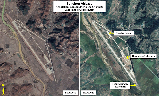
In the midst of all of these removals, the Sunchon Airbase underwent an expansion beginning in 2021 and ending in 2023. The Center for Strategic and International Studies has tracked the progress of this project in detail (Part I, Part II, Part III), but it involved the addition of a 300-meter runway extension, the construction of 16 aircraft shelters, a new hardstand with space for 15 aircraft, and all surfaces have been repaved.
With all of these changes, I think a current round-up of North Korea's aviation infrastructure is in order.
Excluding the now former airbases, there are 128 identified airports, landing strips, helipads, emergency runways, and UAV facilities.
There are six primary airbases, 26 additional airbases with paved runways, 22 basic airfields (including grass landing strips), 30 emergency highway runways, 35 helicopter facilities, and seven UAV sites (which is a topic for another article). I also have the locations of 18 former and disused runways. That figure may change in the future as additional sites are discovered (such as demolished runways that existed during the Japanese occupation or Korean War).
With the exception of Uiju, no major airbases or runways have been affected by these changes. Practically speaking, only redundant airfields were demolished and whether or not Kim Jong Un has an on-site palace runway for his personal use makes little difference to the military.
I would like to thank my current Patreon supporters who help make all of this possible: Alex Kleinman, Amanda Oh, Donald Pierce, Dylan D, Jonathan J, Joel Parish, John Pike, JuneBug, Kbechs87, Russ Johnson, and Squadfan.


