Monday, March 30, 2015

Major Landslide in North Hamgyong Province

Looking at imagery from Myongchon County, North Hamgyong Province (near the Mt. Chilbo National Park), I found what seems to have been a major landslide.

Due to North Korea's mountainous terrain and frequent floods, landslides are a fairly common occurrence, but this one consisted of a 900 foot high hillside collapsing.

Here's the area on June 19, 2011:


And after the landslide in 2013:


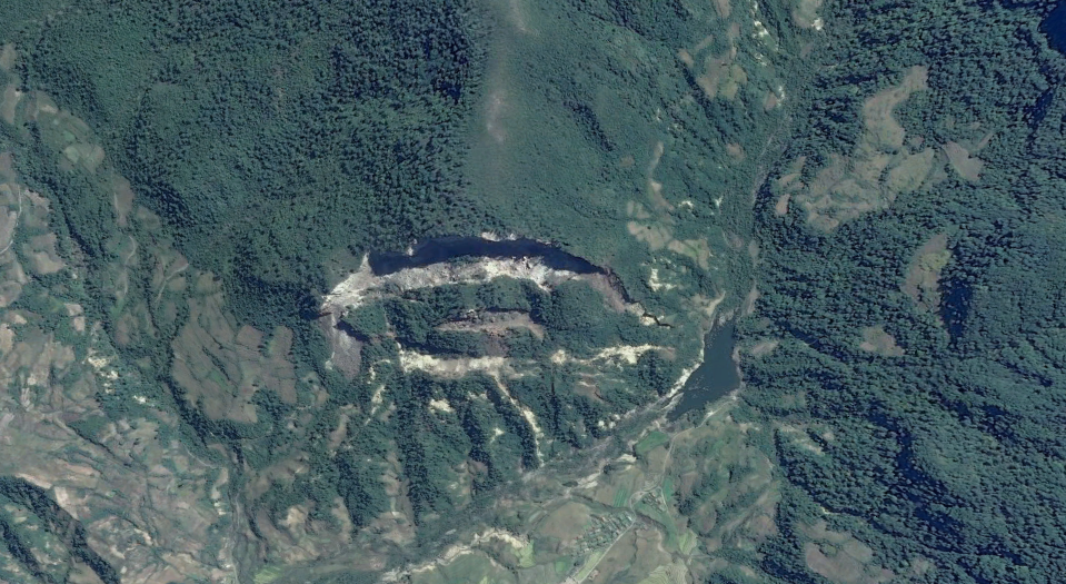
The crest of the hill is 894 feet above the valley floor below. The width of the collapse is nearly a kilometer, at 3,000 feet. It also interrupted normal runoff and thus created a small new lake (right-side of collapsed area). The lake covers about 4 acres (1.6 hectares). The exact coordinates are:  41° 7'33"N 129°30'39"E.

Here's a side view of the area before and after the event:


In June of 2011, there was major flooding in South Korea that also affected parts of North Korea. While it's impossible to tell when exactly this landslide occurred given available information, it's conceivable that the flooding in 2011 played a role.

The Mt. Chilbo area is a very popular tourist destination and is also an important ecological region. According to UNESCO, it holds 16 endemic plant species, 30 endangered plant and animal species, and has 132 medicinal plant species. The geologic origins of the Mt. Chilbo area come from volcanic eruptions relating to the Paektu Volcanic Zone (though, this particular area hasn't been volcanically active for millions of years). 


--Jacob Bogle, 3/30/2015
www.JacobBogle.com
Facebook.com/JacobBogle
Twitter.com/JacobBogle

Saturday, March 28, 2015

Kumgang Airbase Update

Three years ago, a new airbase appeared in a mountain valley 10.4 miles (16.7 km) west of the city of Chanjon, and 5.3 miles (8.9 km) north of the smaller town of Kumgang, Kwangon Province.

Changjon has had a number of improvements since 2005, including a new golf course, and a renovated harbor. It's also home to a naval base. Of course, Kumgang is nearby the very popular Mount Kumgang park.

The airbase was built between 2010 and October 2012. It has a 3,275 foot (1 km) long single runway and basic support facilities. It replaces the much smaller grass airstrip that once served the Kumgang area.


Here are the exact coordinates: 38°42'5"N 127°59'45"E (link opens Google Maps).

(Click image for larger view)

The facility has several aircraft dispersal pens, bunkers for either storage or maintenance, and 3 small fuel tanks. It will likely be used for civilian purposes, but as it stands, it can be considered primarily a military asset given its structure. 

Despite being fairly new, and the levee built to divert the nearby river (North Korea has built many runways very close to rivers, which doesn't seem prudent), the place seems somewhat deserted and has been flooded at least once.


Also, between 2007 and 2012, the surrounding area saw some upgrades too. A new communications tower was built as well as new housing.


There are no defensive artillery emplacements (that I can find) which typically guard airbases of this size, but there are a few small military units up and down the valley. The town of Kumgang itself, though, is protected by 3 anti-aircraft artillery emplacements which contain a combined 18 guns.

When it comes to completing projects, North Korea can accomplish seeming wonders in a short time (except the Ryugyong Hotel, and the fact that most things aren't built very sturdy), but when it comes to making good use of them, things tend to take a while. 

The newest images freely available date to October 2013 but given that so much effort is being placed on Pyongyang and Wonsan, I don't think the Kumgang area will see much more activity for a while.

--Jacob Bogle, 3/28/2015