Sunday, April 28, 2013

New Military Constructions for Artillery

I was going about my business mapping North Korea when I came across an odd set of trenches, and then more of them and more. After looking at their design it became somewhat obvious that these were new hardened emplacements for artillery.

This map gives you a broad view to help you understand their location with respect to well-known cities and islands.


In all I found 21 new sites as well as 1-2 more in the process of construction. Some of the placemarks represent two sites which are side-by-side, in total there are 24 of these "tunnels."

Here is a close-up map of all of the new locations:


The one in the center of the group can be found at 37°48'23.31"N 125°28'5.17"E. All of the other ones are within 1.5 miles of the center.

They all have the same layout, a curved entrance with a "pad" in front and they're all dug into the sides of hills. This is a detailed image of several of them in a cluster.


Each entrance is 21-24 feet wide and from the entrance to the access road is around 100 feet. All of the access ramps are aligned so that the entrances are either facing the north or west.

Also, the area has had a fair amount of new construction with new roads and new buildings.

Here is the central region on Nov 25, 2011:


The same area except on June 20, 2012:


A close-up of some of the buildings:


And finally, a detailed image of the northern most region:


Based on the dates for the past imagery this entire project was built in less than a year. The location of this facility is less than 14 miles from Yeonpyeong Island, SK and less than 61 miles from Incheon International Airport and mainland South Korea.

This has been a rather unpleasant discovery.


--Jacob Bogle, 4/28/2013
www.JacobBogle.com
Facebook.com/JacobBogle
Twitter.com/JacobBogle

Saturday, April 27, 2013

Coastal Defenses

North Korea's coasts are littered with defensive positions, a hodgepodge collection of modern defenses mixed with those remaining from the Korean War.

Their design takes a layered approach and is dependent on the topography of the area. Naturally, locations closer to the DMZ and those along the eastern coast (facing the historical enemy of all Korea, Japan) are more built up. To the southwest, the land border between North and South Korea gives way to a series of river mouths and tidal inlets, most notably at the confluence of the Imjin and Han rivers. This area opens up to the sea and is where I consider the North Korean coast in this region to being.

Within 3 miles of the Northern Limit Line (the de facto maritime border between the two countries, although it is disputed) are a series of observation posts located along the river banks, fences to the rear of the posts, a number of sand berms which divide up the patty fields, successive layers of road blocks/tank traps, and mixed throughout are anti-aircraft artillery sites (AAA), gun lines, trenches dug into the hills, and hardened artillery sites (HARTS). There are also ammunition caches and other storage facilities dispersed throughout.

Here is a sample region.

(click images for larger view)

The Northern Limit Line runs in the middle of the river, naturally South Korea is to the south. The wider yellow line is the area I have marked as encompassing most of the border defenses which include the DMZ. It is approximately 3 miles (with some variation) from the NLL and the Military Demarcation Line which serves as the land border. The "P" icons are small position, observation posts etc. The red circles are HARTS positions, the "S" icons are storage facilities, "F" is for fortifications, the pink icon denotes bunkers or tunnels and the "policemen" mark road blocks of the type I discussed in this post

Here is an example of the sand berm and fence which runs the length of this region (as well as nearly all low-lying coastal areas).


To the north of this beach, in an area about 5 miles wide, there are 8 road blocks.


Now, moving away from the NLL here is a map of some of the small coastal positions located along the coast of South Hwanghae province. 


The island to the bottom right, labeled Keunyeonpyeong-do (also known as Yeonpyeongdo), is the South Korean island which was bombed by the North in 2010 which killed 4 and wounded 18 others. 

This is a close up of one of the larger positions. 


Literally thousands of miles worth of trenches can be found throughout the county. Some are left over from the Korean War and have no real use, but others are part of their active defenses. Like these:


Both east and west coasts are intermittently lined with obstacle courses aimed at preventing any rapid movement inland during an invasion. These "dragon's teeth" consist of row after row of concrete blocks which have been sunk into the sand. The rows, usually 10 running parallel to each other, make up a full "band" around 100 feet wide. Most of these were put in place decades ago, some have been removed and others still have simply been covered up with drifting sand and mud. Still, in some areas they would slow an advancing force. They tend to be found in low-lying areas which lack mountainous terrain within a few miles of the coast and they are often paired with road blocks and berms further inland as well as rows of berms along the beach itself.

In this example the obstacle band has been marked in red, you can see the multiple sand berms in nice little rows.


And a close-up of the dragon's teeth themselves:


Next is the defensive positions around a few coastal towns. If you look at the coastal defense map I gave you above, this area is roughly the 4 blue places marks in a cluster, to the north of Yeonpyeongdo Island. 


The blue lines are fences and the three red lines are the tank traps. As before, the red circles are HARTS, the blue marks are small positions, "G" is a gun line and "B" is a coastal battery.

Finally, these are just three additional images of some interesting coastal places:

An AAA site with trenches - 


A close-up of a hardened artillery site - 


And a reserve fleet of 10 ships. There are a number of these types of locations dotted around the coast. Some are just sitting in dry docks like these and others are actually housed in underground naval yards.


--Jacob Bogle, 4/27/2013

Monday, April 15, 2013

News on the Nuclear Situation

According to an unclassified section of a report released by the US Defense Intelligence Agency (Dynamic Threat Assessment 8099: North Korea Nuclear Weapons Program):

   "D.I.A. assesses with moderate confidence the North currently has nuclear weapons capable of delivery by ballistic missiles; however the reliability will be low.” 

This definitely raises the stakes of the game. China has helped to funnel billions into Pyongyang (£4 billion yearly in official trade and £7.6 billion via black market activities) as well as provided them with military technology. And now, despite taking some actions against North Korea in response to UN sanctions, it would seem that the link between the two countries is anything but severed.

Chinese Embassy in Pyongyang


Based on war preparations by Kim Jong-il, North Korea has stockpiled six months worth of fuel to support any war effort they may undertake. And while they do not expect help from China should they invade or attack another country, they do expect China would come to their aid should the US or South Korea attack the north. That being said, the technology needed to hit a mainland US city with a nuclear warhead is very advanced. The north hasn't been keen on acquiring modern missile technology from either Russia or China but rather seems intent on developing their own technology as required under the Juche (self reliance) policy. The problem isn't that they lack the ability to miniaturize a bomb, it's the ability to mount it (with confidence)  and have the guidance systems needed to reliably hit something that they lack.  

Tonghae (Musudan-ri) Missile Test Center


Which leads me back to some statements I made in my previous post on the issue. Even though North Korea has thousands of tons of mineable uranium ore, they only have enough processed material to make 3-12 weapons (depending on who you ask). And while they have begun to restart the Yongbyon reactor, it could take a year or more for them to process enough fuel rods (they have 12,000 of them) to extract fissionable materials of the quality needed for a bomb. So what is a more likely threat - the threat of launching a missile at us and chance wasting the valuable materials should it fall into the sea, or the risk of them sending a miniaturized bomb in a shipping container?

Yongbyon reactor facility


North Korea runs one of the most successful smuggling programs around. They ship weapons parts to Iran, Syria, Burma  and Libya, plus drugs and counterfeit US currency to places like China and throughout Africa. Not to mention human trafficking. All of this to me says that if North Korea wanted to attack the US mainland with a bomb, they would most likely use unconventional means.


Additional Reading:
North Korea's Nuclear Weapons: Technical Issues, Congressional Research Service (PDF)

--Jacob Bogle, 4/15/2013
www.JacobBogle.com
Facebook.com/JacobBogle
Twitter.com/JacobBogle

Thursday, April 11, 2013

Pyongyang Palace and Update

First, I have set up a dedicated "Google Site" to host my KMZ files. This way I don't have to wait for moderators to approve them and can easily publish updated versions. The following areas have been completed:

Rason Special City
The Demilitarized Zone
Pyongyang (city and district)
Ryanggang District
Ryongsong Residence

You can find them all here https://sites.google.com/site/mynorthkorea/files

(NOTE: the above areas have been substantially updated since this post was published. The new files will all be released sometime around Dec. 2015 and early 2016. Please check newer blog posts for additional updates.)

Now, I'd like to introduce you to the Ryongsong Residence (also known as "Residence No. 55"); the main palace compound of the Kim family.

Located 7.5 miles from Kim Il-sung Square in Pyongyang, the compound grounds total between 5 to 7 square miles (depending on which areas you include). You can find it by using these coordinates 39° 6′ 58.96″ N, 125° 48′ 20.94″ E

Originally built in 1983 by Kim Il-sung, the compound is heavily defended, contains multiple houses (for the Kim family and ruling elite), man-made lakes, a private train station, is supplied power via 3 (known) substations, and much more. Outside the complex lies several anti-aircraft artillery sites and within are numerous underground facilities aimed at keeping the military functioning in the event of a nuclear war. It is also rumored that there are minefields in and around the compound, but I have not been able to verify their locations.

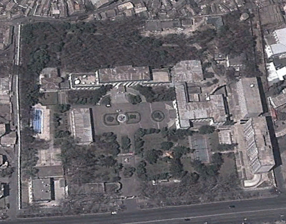
This gives you the location of the complex in relation to Pyongyang proper and the main airport. This image also shows the outline of the main outer and internal fences. As always, simply click on an image for a larger view.


Here is the area without any markings:


A up-close image of the fences. Red is the outer fence, purple is the main fence which is actually several electrified fences, walls, firing positions, etc. which encircle the compound as a thick fortified band.


The complex is also further divided by multiple internal fences (yellow). These fences often surround high priority areas, like the official residence of Kim Jung-un.


There are other fences and walls inside the complex which usually surround various buildings, greenhouses, barracks, etc. I have not marked those as they are difficult to fully discern and are rather numerous.

This shows you the location of the defensive ring around the compound which includes 15 AAA sites and 1 HARTS (hardened artillery site) position. These are only the ones closest to the complex, if you were to zoom out there would be more and more of them which are a part of Pyongyang's overall defensive network.


Here is a map of the multiple guardhouses and gates. There are also at least 2 berms (denoted by the square icon) which would prevent tanks from being able to rush certain areas.


This close-up gives you a better understanding of where the main residences are located and the layout of the internal fencing system. The blue circle denotes a bunker.


Here you can see the main fence design as it snakes across the image:


The private train station:


The location of the 3 substations. It is possible that there are underground power supplies but obviously, you can't see them from the air.


Here is an example of a livestock area within the compound (probably chickens or pigs). The compound, like a small city, is surrounded by agricultural, livestock, and military units. The building to the right is one of the substations.


This shows you some of the bunkers and underground facilities.


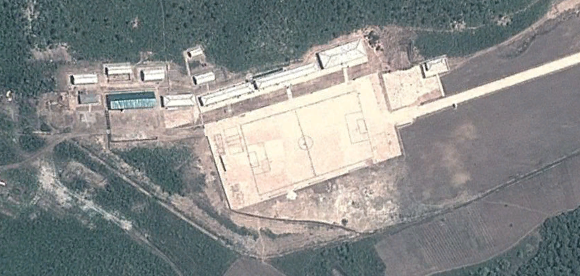
The Kim family have long held a fascination with horses and so, they have their own horse track. You'll notice the single, small viewing stand.


The main horse arena with stables:


Some of the smaller residences:


These 2 buildings are the largest single residential structures that have been on the property.


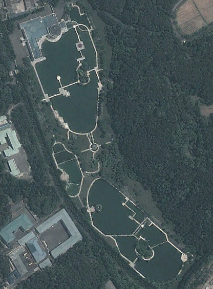
Here we have the main residence of the Kim family. The man-made lakes are a staple of the many official residences scattered throughout the nation. The distinctive geometric walkways over the lakes are likewise a mainstay of the palaces.


And now we get to see a bit of fun, a pool with a rather wild looking water slide:


Over the years the complex has undergone many changes and since 2009 there have been a number of them. The structures below were built between April 2009 and October 2010. These are located immediately adjacent to the livestock area and occupy the field to the center-bottom of the image I used for that site.


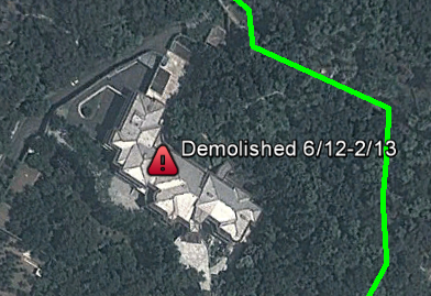
A number of homes were destroyed between April and September 2011, and after the death of Kim Jong-il, Kim Jong-un ordered the destruction of many (but not all) of his father's palaces and villas, as well as those homes belonging to those who did not show proper loyalty to Jong-un after his rise to power. The demolished homes have their approximate date of demolition, two of which may be candidates for Jong-un's demo project.


This large residence was demolished after the death of Kim Jong-il. You'll notice that it is one of the larger homes I showed you earlier.


The money spent to build and maintain this complex, along with all the others, cannot fully be ascertained. But given the fact that anywhere from 1-44% of the nation's economy is spent solely on the cult of personality that pervades North Korea, one can suspect that the finances used for these palaces are placed at a far higher priority than that of the starving and tortured average North Korean.


Additional reading:
Ryongsong Residence (Wikipedia article)
Cult of personality figures: 1% (based on GDP of $40b) - http://www.huffingtonpost.com/2012/12/05/kim-jong-il-cult-costing-north-korea-millions_n_2245711.html and 44.8% http://www.nknews.org/2013/04/what-to-make-of-pyongyangs-recent-political-meetings/


--Jacob Bogle, 4/11/2013
www.JacobBogle.com
Facebook.com/JacobBogle
Twitter.com/JacobBogle

Friday, April 5, 2013

Mapping Update 3

First, I'd like to apologize for not posting lately, especially given the rising tensions. I moved into a new apartment and ran into some issues with my Internet, leaving me without it until today.

That being said, the total number of new placemarks is now over 4,000. I have also published the KMZ file for the Rason Special City. It contains 77 placemarks and you can find it here (this will take you to the Google page where you can download it by clicking the link on that page, you must have Google Earth to view it.)

I am nearing completion of Pyongyang (around 1,000 items) and I am in the process of making a special file specifically for the main palace in Pyongyang. The palace and surrounding area are well known but the descriptions and related files are incomplete. It will also be the subject of one of my next posts so you'll get to see lots of images.

Also, version 1 of the DMZ file is available. You can find it here. It has roughly 190 items marked. I am working on version 2.0 which will have ~30 new places as well as being better organized.

Finally, I have changed mapping techniques. In the past I would map a large city and work my way outward and follow rivers and valleys. This worked surprisingly well but inevitably I missed places and the shear volume of space to cover was rather daunting. So now, I've begun to divide the whole country up into 5x5 mile squares. Given GE's eccentricities this is taking up a fair amount of time, but I can easily manage the 25 sq mile blocks, be fairly confident that I have spotted everything in them and being able to "check-off" each completed square gives me a bit of a morale boost.


--Jacob Bogle, 4/5/2013
www.JacobBogle.com
Facebook.com/JacobBogle
Twitter.com/JacobBogle