Showing posts with label DMZ. Show all posts

Wednesday, December 21, 2022

Dissecting the DMZ

I've written about the DMZ before, discussing how it has changed over the last decade or so. But now I would like to go into greater detail about its actual functionality - how it's laid out, what kind of defenses exist, and what kind of offensive capabilities are contained within.

The DMZ (demilitarized zone) is defined as a buffer zone between the two Koreas. It extends for 250 km across the peninsula and is approximately 4 km wide. However, the only fully defined part of the DMZ is the "military demarcation line" (MDL) which is the de facto land border - the actual line dividing the countries. On either side of that line is the buffer zone, which happens to be the most militarized area in the world.

In practice, the part of the DMZ that is actually devoid of any soldiers varies considerably in width. And the width of the various integrated defenses on either side of that no-man's land also varies. For the purposes of the AccessDPRK maps and this blog, I classify military sites within 5 km of the military demarcation line on North Korea's side as "the DMZ", because within that area lies an almost uninterrupted web of observation posts, storage sites, bases, artillery positions, and other sites that clearly form a unified military infrastructure.

General DMZ overview. The military demarcation line (MDL) is in yellow, and the two rows of electrified DMZ fencing are in white.

Detailed look at the DMZ's layout with the MDL dividing North and South Korea, an empty "no man's land" (green area), and the two heavily militarized fences on the North's side.

What became the DMZ largely reflects the battlelines as they existed in 1953. On the North Korean side, relics of the Korean War can still be seen including cratered hillsides and trench remains. And many of the extant static defenses such as anti-tank ditches and dragon's teeth can be traced to the 1960s and 1970s. Although some of these sites have been heavily impacted by erosion and would offer little practical defense today others still exist in good condition, and the manned instillations along the DMZ are routinely maintained and hundreds of new sites have been constructed over the years.

With thousands of manned positions and hundreds of kilometers worth of trenches and anti-tank ditches, the DMZ is a considerable defensive line. Because of this complicated layout, I want to try and "dissect" it piece by piece. 

One last note, the images used are chosen because they provide a clear view of the site being looked at. Image quality can vary a lot, so the most recent image may not display the best visuals. Perhaps there's cloud cover, it's too dark, too bright, at the wrong angle, etc. However, if an image I've chosen does happen to be from several years ago, that site still looks the same as it does in recent images. The older image is simply "prettier" and makes it easier to show the necessary details. 


Order of Battle

The exact details of North Korea's order of battle aren't fully known publicly, but what is known would still take up more room than I have for this post. However, the Ministry of Defense (formerly the Ministry of the People's Armed Forces) deploys roughly 70% of its active duty ground forces south of the Pyongyang-Wonsan line that lies roughly 120 km north of the DMZ. A substantial portion of the Navy and Air Force is also positioned within that area as are five short-to-medium-range ballistic missile bases.

Some of the details include that the DMZ is manned by members of the Korean People's Army I, II, IV, and V Corps according to Joseph Bermudez's book The Armed Forces of North Korea. Their operations are under the command of the Third Department of the General Staff Department's Operations Bureau which is part of the Ministry of Defense and subordinate to the State Affairs Commission.

These Corps represent the First Echelon of KPA Ground Forces and defend the DMZ and the areas immediately behind it. The Second Echelon of forces (which include the 820th Tank Corps and 815th Mechanized Corps) are tasked with defending the main invasion avenues into North Korean territory on the approaches to Pyongyang.

Each Corps will have their own specific makeup but, in general, they will consist of light infantry brigades, artillery brigades, tank brigades, sniper units, anti-tank units, electronic warfare/SIGINT units, reconnaissance units, communication and transport units, engineering regiments, and others. They will also have units assigned to chemical warfare and nuclear defense (although not nuclear weapons).

Special Operations Forces are also deployed along the DMZ and are under the command of the Reconnaissance Bureau and Light Infantry Training Guidance Bureau. 

The 3rd Air Division is responsible for protecting the south of the country and the DMZ. Immediate aerial support could be provided by the eight closest primary airfields and would include support from SU-25s, MiG-17s, MiG-29s, An-2 biplanes, and MD-500 and Mil Mi-2 helicopters (among other manned aircraft and UAVs). There are also 29 additional runways, landing strips, heliports, and emergency runways within 100 km of the DMZ. And, of course, fighter and bomber aircraft could be sent from any of the airfields in North Korea, not just the ones in closest proximity. 

Ballistic missiles under the control of the Strategic Rocket Forces would be used to destroy key targets within South Korea and to help Special Operations Forces disrupt and push back an invasion by South Korea by opening up a "second front". 


Invasion Routes

Hypothetical south-to-north land invasion routes based on favorable geography.

Several portions of the DMZ serve as natural invasion routes that could be used by either side to invade the other. From a defensive perspective, the North Korean fortifications would stall an invasion coming from the South that would likely be funneled through the low and flat terrain between Kaesong to Pyongyang (an invasion route that has been used historically for over a thousand years), north toward the city of Koksan which would take out several important infrastructure sites and also grant access to Pyongyang, from the South Korean city of Cheorwon to North Korea's Sepo and through a valley into Wonsan (cutting Kangwon Province in two), and lastly through the narrow plain that exists along nearly the entire east coast (also an historic invasion route)

To help slow down a ground invasion, a network of unmanned static defenses has been constructed over the decades. Many have been impacted by time and erosion, but the sheer number and breadth of them means that they remain an obstacle that would have to be taken into consideration.


Unmanned Anti-invasion Defenses

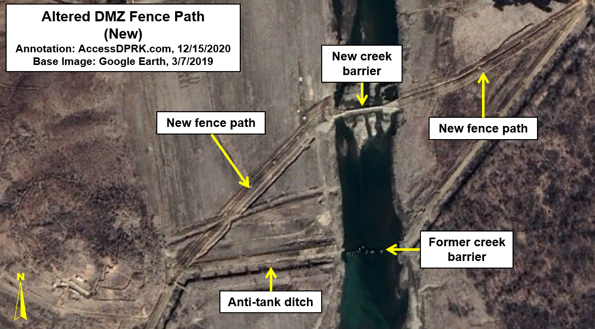
Except for a mountainous border region in Kangwon Province where there is only one line of fencing, the DMZ is protected by two lines of electric fencing. Each line of fencing (separated by 0.5-1 km) consists of two parallel rows of fence. The fence lines are dotted with around 10,000 foxholes in total. There are at least 99 gates in the second (interior) fence line as well that allows KPA personnel access to the first (forward) fence, observation posts, and foxholes.

Example of one of the gates in the second fence line.

In low-lying areas like valleys and plains there are anti-tank ditches, anti-tank walls, and rows of dragon's teeth (pyramidal shaped concrete blocks that can't be driven over). I've located over 80 km of anti-tank ditches/walls and 56 sites where dragon's teeth are present within the 5 km designated area. 

Close-up image of some of the complex fortifications along the DMZ. The orange lines are anti-tank ditches, beige lines are dragon's teeth, and the icons are roadblocks.


Wider view of the unmanned static defenses near Pyonggang, within the Cheorwon-Wonsan invasion corridor.

Roads in and around the DMZ are not paved but are simply winding dirt tracks. This is actually part of the overall defensive strategy as such roads force vehicles to slow down and do not provide direct routes further into North Korean territory. These roads are protected by large anti-tank blocks/roadblocks that can be knocked over into the roadway and block vehicles from passing until the blocks can be removed. There are around 170 of these sites within 5 km of the MDL and dozens more outside of the immediate area.


Manned Defenses 

Various fortifications and related sites within the defined 5 km area. The white lines are the main fences and the orange and beige lines are anti-tank ditches and dragon's teeth. Observation posts (OP), forward posts, munitions storage igloos, gates, small units, and hardened artillery sites are all within this section.

If one were to look at a cross-section of the DMZ, its layout would generally follow this pattern (moving north from the MDL): fence #1, observation posts (ops), forward posts, fence #2, additional posts (entrenched positions, fire teams, artillery), and then medium- and long-range artillery positions such as HARTS. 

Back from the second fence are also munitions storage sites, larger bases/units, vehicle facilities, and other supporting instillations that are interspersed throughout. 

According to the AccessDPRK 2021 Map, there are 544 independent observation towers.

Immediately behind the first fence, spaced anywhere from 0.5 to 2 km apart, are 183 "forward posts" which are the forwardmost manned positions capable of shooting back at an enemy. These posts vary in size but are surrounded by trenches and include their own observation sites as well as fire control centers, fire teams, and can also have entrenchments for short-range artillery and mortars. 

Forward posts are usually positioned on hilltops such as in this example. A network of hundreds of kilometers of trenches weave their way through the whole DMZ.  

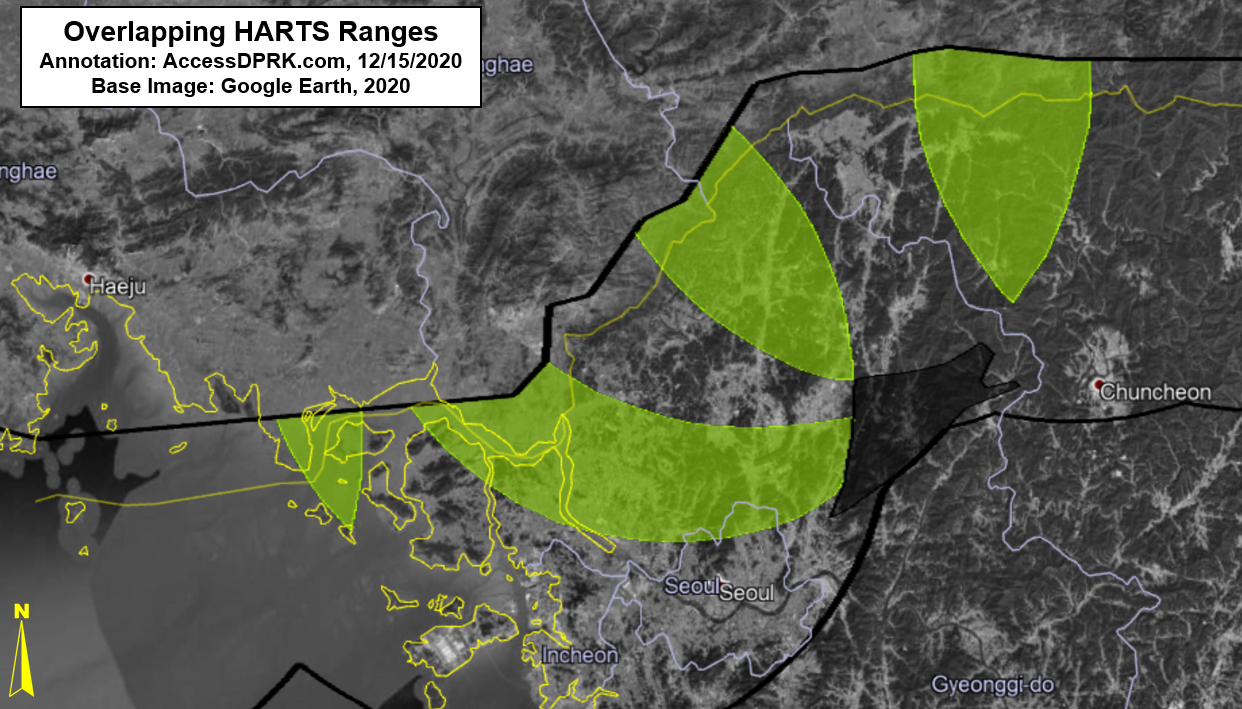
HARTS (hardened artillery sites) deploy 4-8 artillery pieces such as 122 mm and 152 mm howitzers. The guns can be rolled out onto prepared positions, fired, and then pulled back underground for protection. The underground facility can also provide additional storage and even protected living quarters if needed. In the example shown, additional large bunkers exist to the right of the HARTS installation. 

There are 69 HARTS positions within the 5 km area. Between 2009 and 2017, a total of 126 new HARTS and hardened Multiple Launch Rocket System emplacements were constructed within range of the DMZ and can hit targets as far away as Seoul. They represent 20.7% of all HARTS located within 100 km.

Typical example of a mortar line.

Mortar emplacements can exist as part of a larger fortified site or, as in the example above, as stand-alone sites. As is often the case with all types of artillery across the DMZ, this mortar line exists on the downward (back) slope of a hill providing defilade protection against a counterattack because its position is not in direct line of sight but obscured by the hill.

There are also dozens of empty prepared positions along the DMZ for artillery. Some sit in the open and others have small bunkers for protection. These are reserve sites that allow artillery pieces to be moved in from elsewhere and from site to site to add additional fire power in a specific region as needed, but whose destruction wouldn't significantly degrade North Korea's capabilities since they can quickly be repaired or simply abandoned, and the artillery moved to another site. 

Example of a small base.

There are around 800 fortified positions (including artillery) and rear support bases that lie 1-2 km behind the second row of fencing. Excluding artillery sites, these bases tend to be small (only a few buildings) and may only have specific functions like billeting troops, providing vehicle storage and maintenance, storing weapons and other equipment, serving as command and communication centers, and some will include field hospitals. 

The DMZ is filled with storage sites, from the underground facilities at HARTS to munitions bunkers at mortar lines to partially underground cellars at hilltop bases. But there are also more traditional storage igloos (or bunkers) that dot the landscape.

The storage bunkers are relatively small, with an interior space of no more than 50 sq. m., and consist of a concrete box that has been positioned within a berm or other revetment for safety. Some are located alone as a single structure while others are clustered together in groups of ten or more bunkers.

Between bases, forward posts, observation sites, HARTS, mortar lines, gates, and other sites, there are at least 1,700 manned facilities within 5 km of the MDL in the AccessDPRK 2021 map, but precisely identifying and classifying the locations along the DMZ isn't exactly straightforward and the number of locations could be higher depending on how they're classified/organized.


For aerial defense, not only does North Korea have the aforementioned airbases within 100 km of the DMZ, but there are also eight surface-to-air missile batteries that form a line across the peninsula and are within 50 km of the military demarcation line, and a further ten SAM batteries are within 100 km along with several other permanent installations that can be used for mobile SAM systems.


There are also around 200 shorter-range anti-aircraft artillery (AAA) batteries within 100 km that can attack ROK/US aircraft that try to penetrate into North Korea; although, their effectiveness against modern jets would likely be minimal as most aircraft can fly above the range of AAA systems and may never be forced to come within range of their guns.


Final Thoughts

In the event that South Korea were to launch an attack, North Korea's response wouldn't only be to hold off the invasion but would most likely trigger a counterattack to capture Seoul before the United States could transport more troops and equipment from bases in Japan and Guam. While any attempt to hold Seoul would fail, the battle for the city (no matter how temporary) would result in tremendous civilian casualties. North Korea could unleash a barrage of chemical weapons on the city, and it could use long range ballistic missiles to knock out US capacity further afield by attacking Guam, slowing any allied response.

It is this terrifying risk of Seoul, a city of 10 million, being bombed into oblivion and the severe disruption to global trade that has held off the US and South Korea from ever preemptively attacking North Korea's nuclear and missile sites or assassinating a Kim. 

Although technology has advanced and a concerted allied attack on DMZ positions could destroy most North Korean positions within 72 hours, Pyongyang would follow any attack with missiles fired from bases further inland, some deep within mountain ranges. Complicating matters even more is the fact that the US does not have confidence in its ability to take out all of North Korea's hardened positions and their mobile ballistic missile forces before North Korea could fire off a nuclear weapon.

And so, the DMZ - for all of its outdated dragon's teeth and Soviet-era artillery - remains an incredibly dangerous tripwire that could trigger a war no one genuinely wins. The threat of a conventional bombardment of Seoul from the DMZ bought North Korea the time to build a credible nuclear deterrent, and now that deterrent has made the risk of even a conventional conflict along the DMZ too costly. 

In the meantime, an ever-advancing arms race continues and the rhetoric coming from either side of no man's land suggests the DMZ will remain a scar across Korea for years to come. As I have shown in previous posts, the DMZ isn't unchanging. And with no clear path toward peace, let alone reunification, it's important for the world to keep an eye on this narrow strip of land that serves as the most militarized demilitarized zone in the world.


I would like to thank my current Patreon supporters: Alex Kleinman, Amanda Oh, Donald Pierce, GreatPoppo, Joel Parish, John Pike, JuneBug, Kbechs87, Russ Johnson, and Squadfan.

--Jacob Bogle, 12/21/2022

Friday, December 18, 2020

The Ever-Changing DMZ

The Demilitarized Zone that separates the two Koreas is a bit of a misnomer. The super thin strip of land 4 km wide was created as part of the 1953 Armistice and aimed to keep both militaries apart and to create a safe, clear buffer zone. However, immediately on either side of the DMZ lies the bulk of both nation's armies.

"The Frontline". Image taken in 2012 by the Republic of Korea Armed Forces. Image source: Commons (CC BY-SA 2.0). 

And while the United Nations' stipulated boundary (on paper) hasn't really changed over the years, the physical boundary itself has (as defined as the fences both sides use). Indeed, the path of the electric fence that runs for 250 km across the peninsula has changed more than once, and the small guard huts are constantly being built, torn down, relocated, and then moved again. 

The effective border between the two countries is a line drawn in the center of the DMZ called the Military Demarcation Line. On each side of that is a narrow "no-man's land", penned in by the inner row of fences, and then a second line of fencing about half a kilometer from the first. This is supposed to create the 4 km-wide demilitarized zone, roughly 2 km on the north side of the MDL and 2 km on the southern side. However, the actual real-world width can vary considerably as both sides have tried to take advantage of the hilly terrain. In some places from the second line fence in North Korea to the second line fence in South Korea, the distance is 3.5 km, while in other spots it's nearly 6 km. 

Fences of the DMZ. The central yellow line is the Military Demarcation Line. The "practical" DMZ is bounded by the northernmost and southernmost fences. (South Korean fence paths, in pink, kindly provided by Javier Rives.)

This variation in the "practical" DMZ has led me to use a line that's roughly 4 km from the MDL to serve as the DMZ zone of immediacy. This isn't the 4 km of official DMZ width, but 4 km starting at the MDL and moving north into North Korea. 

The zone of immediacy not only includes the truly demilitarized no-man's land, but also the rows of guard towers (which are manned by soldiers), and numerous artillery and other military positions that form the country's first line of defense as a clearly connected set of military sites that stand apart from other defensive lines farther inland. It is within the DMZ-proper and the zone of immediacy that this article covers.


CHANGES TO DMZ FENCES

While the demarcation line doesn't change and the official layout of the DMZ doesn't either, the practical boundaries are created by two rows of electrified fences. The fences are guarded by hundreds of observation posts and even have machine gun nests constructed along the entire length of the DMZ; roughly one every 60-100 meters. Of course, those positions aren't manned and would only be used during a conflict.

Over the decades, the fence positions have been modified to take better advantage of the terrain and to allow for the best defensive posture while needing the fewest resources. One of the most recent examples of this is a 660-meter stretch at 38.065069° 126.847214°. It was built in late 2018-early 2019 and adjusts the fence's path slightly to the north. The original anti-tank ditch still exists but the old fence has been removed.


An example of a planned change that was never carried out can be found at 38.355133° 127.592494°. Sometime prior to 2007, the regime cleared a path 1.3 km long and ~12 meters wide along a hillside. They also dug machine gun emplacements. However, they never completed the new fence, and today the original fence remains while the 2007 path and emplacements sit largely unused; although, it does appear to have been kept clear of new brush growth.


One of the largest changes in recent years actually lies at the end of the official DMZ and at the beginning of the Northern Limit Line, the maritime boundary between the two countries. The DMZ itself ends south of Kaesong, as the Han River and its estuary form a natural boundary. But both sides have those coastlines heavily fortified as well, and the double line fencing system carries on for another 53 km, until it reaches the Ryesong River. 

That fencing originally ended at a pier on the river at 37.925110° 126.393169°. Around 2013, however, the regime extended one line of fencing up the river for a further 3.4 km. It now ends at a small mining village located at 37.952588° 126.392990°. The rest of the country's coast is fenced off as part of an anti-migration barrier.


CHANGES TO OBSERVATION POSTS

Cropped photo of North Korean DMZ guard post as seen from a South Korean post. Image: AP/Ahn Young-joon.

In 2018, North and South Korea demolished ten guard posts each on their respective sides of the DMZ as a show of good faith during a period of diplomacy. This was the first time such an action had been taken and it was met with widespread international praise. 

Unfortunately, as has happened for decades, each time the two sides try to work together, the diplomatic efforts quickly wane and grand schemes for cooperation and peace fade as new cycles of provocation begins again. 

While the destruction of the posts may have been the most public demonstration of guard posts changing (either being removed or built), it happens fairly regularly as part of routine DMZ "maintenance," as each side finds better spots to place new posts, removes redundant ones, etc.

In the 2021 version of the AccessDPRK map, I was able to locate 544 stand-alone observation posts along the DPRK side of the DMZ. These small positions are usually manned by 2-3 soldiers, keeping an eye out for any unusual activity coming from the other side and to stay alert for any North Korean soldiers attempting to cross and defect. At least 18 new posts have been constructed since 2015, including at least four that were constructed during or after the joint demolition of guard posts in 2018.

Examples of this newer construction is a guard post that was built in 2018 at 38.344391° 127.593518° and one that was built in 2019 at 38.323211° 127.461832° (pictured below).


HARDENED ARTILLERY SITES (HARTS)

By some estimates, North Korea keeps 60% of its artillery deployed within 100 km of the DMZ. But over the years, the disposition of that artillery has changed. Their deployments, types, and numbers have all varied over time. Of particular concern is their hardened artillery sites (HARTS). 

These medium and long-range artillery positions are very often hidden behind hills or are otherwise obscured from direct line-of-sight (known as defilade) and can hold some of North Korea's largest artillery systems, including self-propelled guns and multiple rocket launchers (MLRs). 

Within 100 km of the DMZ are at least 608 identified HARTS locations, each with multiple artillery pieces. (This figure agrees with the higher-end estimates noted in public sources). Between 2009 and 2017, 126 new locations were constructed, representing 20.7% of all HARTS in the region. 

Almost all of these new sites are within 10 km of the Military Demarcation Line and several are within the zone of immediacy. 

Map of new HARTS positions (2009-2017).

Roughly constructed in 9-10 groups, these HARTS were built to hold self-propelled artillery like the Koksan and 122 mm, 130 mm, and 152 mm systems. One of the most talked about weapons is the Koksan (M-1978) 170mm self-propelled gun. These have a maximum firing range of 60 km. 

The group of positions to the far west of the image is predominately MLRs constructed after the 2010 bombardment of the South Korean island of Yeonpyeong. They are large enough to accommodate the North Korean variant of the Soviet 122 mm BM-21 Grad multiple rocket launcher, which was suspected to have been used during the bombardment.

The rest of the new HARTS sites appear to be for other towed and self-propelled artillery systems.


The above image shows five individual gun emplacements constructed together as part of a single battery. There are a total of three batteries in the immediate area. These three batteries hold 16 guns combined. Fired in a volley, they could launch as many as 560 rounds every five minutes.

You can also notice that they were built as close to the DMZ as feasible to maximize the amount of effective range within South Korean territory. Other HARTS have been constructed farther inland over the decades to serve as a second-line defense in the event of an invasion. These, however, are very much intended as offensive positions to threaten Seoul and ROK soldiers stationed along the DMZ.


According to RAND Corp., a single barrage along the entire length of the DMZ of all artillery pieces (not just the newest HARTS batteries) could fire as many as 385,000 rounds in an hour and kill over 205,000 people.

Due to the overlapping nature of each artillery piece, the following map shows the areas held most at risk by the greatest number of new guns, with some areas being within range of over 30 distinct batteries (each with 4-6 individual artillery pieces).

This map shows the areas under threat from the highest number of new HARTS. The black wedge is also under great threat but lies at the far-end of the artillery's range, meaning fewer shells would likely reach the spot than those in yellow due to the high failure rate of North Korean artillery shells.

Downtown Seoul is in range of at least 30 new batteries but the area just to the north is within range of 47, which is why most of Seoul is not highlighted on the density map.


FINAL THOUGHTS

Other changes occur within and around the DMZ as well, though not necessarily as important as the ones described above. Many places within the DMZ (on both Northern and Southern sides) are routinely burnt to get rid of underbrush and create optimal observation conditions. What environmental impact this burning has on what has become an "accidental wildlife paradise", is little known. This also leads to increase erosion and will speed up the natural change in topography over time.

What began with the intention of being a temporary border has turned into a permanent feature of Korean division that has spanned three generations. The DMZ and the area around it have shaped the lives and destinies of millions and has become a sort of distant backdrop on which their lives play out, but it is certainly not a static feature. Lives are still lost and hopes are raised on this backdrop, but for as long as the peninsula is divided, it will stubbornly remain a symbol and a threat; one that can drastically change with the ebbs and flows of inter-Korean relations.


I would like to thank my current Patreon supporters: Amanda O., Anders O., GreatPoppo, John Pike, Kbechs87, Planefag, and Russ Johnson.

--Jacob Bogle, 12/17/2020
AccessDPRK.com
JacobBogle.com
Facebook.com/accessdprk
Twitter.com/JacobBogle

Thursday, January 18, 2018

North Korea's Great Barrier

I first wrote about North Korea's caged population in 2013, where I showed the fences that surround the country. Since then, I have been able to map the full system of fences, guard posts, and gates. And since the general situation regarding population movement has changed since then as well, I want to revisit the topic and also provide you with the Google Earth file so you, too, can explore the miles of fences and blocked off beaches, as well as to provide added evidence of the horrific human rights situation that exists. If you're primarily interested in getting the KMZ file, click here.

Guards maintaining a section of border fence along the Yalu River. (Source

First, a quick refresher. Much of North Korea's coastline and land borders are fenced off. According to multiple defector and media reports, some portions of fence are electrified while others are simply guarded by police. Of course the southern border (aka, the Demilitarized Zone/DMZ) has been turned into, perhaps, the most impenetrable 820,210 feet (155 miles) of border in the world. Ever. Apart from the hundreds of thousands of troops stationed along the DMZ, it has over 1,000 observation towers and forward military posts. Finally, the border with China (and the small section with Russia) is protected by large reservoirs, rivers, and in many places, fencing as well.
The purpose of these barriers is to keep people inside the country. Construction was sped up during the famine as the regime tried to cope with the mass movements of people, risks of defectors stealing boats, and as the government struggled to maintain their control in all sectors of society.

All of this means North Korea's population really is caged. A more colorful description of the country would be as an open-air prison.

The following images show the extent of the national fence system. Click on images for an enlarged view.


I was able to map nearly 1,400 miles (1,399.36 to be exact) of fencing. There are lots of small coastline sections where the paths of fencing can still be seen, but the fence itself is gone - likely pillaged for scrap metal by locals, however, most of the gaps you can see (and all of the large ones) are due to either natural barriers or where direct access to the sea/border is blocked by an industrial site, military base, or other construction that itself serves as a barrier.

Many coastal towns and villages lack a fence and instead the coastal portion is lined with dockyards and factories which requires locals to go through any number of gates or checkpoints, if they're permitted through at all. I've tried to map as many gate houses as possible that provide direct access to the coast. Ones that simply allow access to a factory or other site adjacent to the sea are not marked.

This next image shows the reason for each of  the major gaps in the fence system.


This image shows 837 identifiable police border guard posts and 434 stand-alone watchtowers along the the DMZ.


Under Kim Jong Un, miles of new fencing have been erected as well as older fencing upgraded in certain areas. A large number of additional watchtowers have been added along the fence routes as well, particularly in the northern regions. However, border controls extend well beyond fences and watchtowers. Cell phone single jamming towers, cameras, and other surveillance equipment have been deployed along both borders, but efforts have particularly increased along the Chinese border (which is the route most defectors take).

A related issue is the increased border protections China has been implementing. As with North Korea, China has begun to build fences (of a far greater quality than the DPRK) along certain key border sections to stem the flow of defectors. They have also constructed signal jamming towers and increased police and military patrols. China's active attempts to catch defectors by checking train stations, setting up road blocks, and patrolling neighborhoods, occur not only in the immediate border region, but far into the interior in major cities like Jilin.

The following series of images clearly show the individual fence posts and come from different parts of North Korea. Additional images can also be found in the original 2013 post, A Caged Population.


As both Kim Jong Un and China have taken a much harder line regarding border security, there has been a real and measurable effect on the numbers of successful defections. In 2017 there were 1,127 defectors who made it to South Korea, which is a decline of 27% from 2016. That was the lowest figure since 2001. The total number of defectors peaked around 3,000 in 2009, meaning there has been a decline of ~62% overall.

Despite the barbed wire fences, guards with automatic weapons, the high risk of women being sold into sexual slavery, and the risks of repatriation and imprisonment (or execution), people still brave the cold waters of the Yalu River and the forests of northern China to find their way to a better life. Even soldiers posted along the DMZ, who tend to belong to elite families and are generally more well off than soldiers stationed elsewhere, accept getting shot at 40 times (or even kill other DPRK soldiers) to cross into South Korea.

Kim Jong Un may have been successful in curbing overall defections, but the drive to feed one's family and the desire to experience the freedoms of the outside world (that North Koreans are increasingly being exposed to) will continue to inspire and embolden people to take the risks and seek a better life.

To download the full KMZ file and explore the sites yourself, click here. (Must have Google Earth to access.)


--Jacob Bogle, 1/18/2018
www.JacobBogle.com
Facebook.com/JacobBogle
Twitter.com/JacobBogle

Friday, January 6, 2017

New launching/landing sites constructed?

UPDATE: These have been confirmed as emergency parking positions for jets, since highways can be used as auxiliary airfields (and North Korea does have at least 14 official "emergency highway strips").


On the heels of Kim Jong-un suggesting that the country is very close to testing another ICBM, I've discovered three sites that could be used as dedicated mobile-missile-launcher pads.

These sites were constructed in 2016 and have the same general design.

The first and largest is near Kaesong and lies less than 10 miles (16 km) from the Demilitarized Zone with South Korea.

Located adjacent to the Pyongyang-Kaesong Highway, by the village of Haeson-ri, this site was under construction in March and had been completed by October 2016.

Each pad is 45 feet (14 meters) wide and the straight portion is 175 feet (53 meters) long. The area around it also contains numerous bunkers and tunnels.

The second site is in Pyongsong, South Pyongan Province, which is 21 miles (34 km) north-northeast of the center of Pyongyang.


Just like the Kaesong site, this one is located adjacent to a main highway. In this case, National Highway 65. The area also has a high concentration of HARTS (Hardened ARTillery Sites), which are marked by the red dots. Several additional military facilities are also nearby.


Lastly, the third site is similar in its size and the fact it's right off a highway, but its design is different. The primary difference is a lack of a central berm. This site is located near Sukchon, also on South Pyongan.


If these are indeed dedicated pads for launching missiles, it would be in line with North Korea's continued modernization and expansion of their offensive capabilities.

________________________________________________________________________________________
I'd like to make a quick note about the #AccessDPRK Mapping Project. Across North Korea, I have located 9,500 military related places. I have finished the primary mapping process and am now working on incorporating the work of two others into a main and comprehensive single file. After that, the entire body of work will be published.

--Jacob Bogle 1/6/2017
www.JacobBogle.com
Facebook.com/JacobBogle
Twitter.com/JacobBogle

Monday, June 9, 2014

North Korea's Beauty & Untouched Wilderness

There is no doubt North Korea is unlike any country on earth. Its heavily regulated society and militarized southern border has actually resulted in some of the most pristine wilderness areas in the modern world outside of the vast tropics. Unfortunately, many of these areas are under threat. I'd like to show you some of these amazing, if not always intentional, wilderness areas.

Korean Demilitarized Zone

DMZ outlined in yellow.

Apart from providing relative military stabilization, the DMZ has also created an unintentional nature preserve 155 miles long and 2.5 miles wide. Not only is it nearly impossible to traverse the DMZ because of the high risk of being shot, the zone also has roughly 1 million landmines left over from the Korean War which makes human movement all the more dangerous. This has meant that the 387 square mile region has been left nearly undisturbed for over 60 years, with the exception of two very small villages (one of which is fake and the other, on the southern side, has a population of 218). This has allowed nature to reclaim the area and bounce back not only from three years of devastating war, but also from thousands of years of human settlement and movement. To quote Don Oberdorfer in his book "The Two Koreas", "This pristine nature preserve marks the most dangerous and heavily fortified border in the world."

The DMZ from the ground.

Within the boundaries of the DMZ there are 2,900 plant species, 70 mammal species, 320 types of bird, and over 80 species of fish. Some of the more interesting creatures include the Asiatic black bear, leopards, and lynx. There are also several animal species that only live within the DMZ. The DMZ plays host to countless numbers of birds each year as they migrate throughout eastern Asia and Japan. Approximately 1/3rd of all Red-crowned cranes (their entire wild population is less than 3,000) use the DMZ during migration.

Pair of Red-Crowned Cranes in flight.

There are several organizations which are trying to have the DMZ, or at least parts of it, declared a UNESCO World Heritage Site and Biosphere Reserve. Author Alan Weisman has said of the area within the DMZ, "it has inadvertently become one of the most important wildlife conservation sites in the world.” There are, however, several major obstacles in the way of preserving the DMZ, not least of which are the ever-increasing levels of pollutants due to substantial urbanization occurring in areas adjacent to the zone. And, the only way for the full area to be protected is for the North Korean government to cooperate with the South, which offers its own difficulties. Tourism to the zone, over 1.2 million people annually, accounts for 20% of South Korea's foreign visitors. If the zone were to be made into a nature preserve, it would be a boon not only to tourism and the economies of both countries but could help bring the two Korea's back together because of the necessary steps needed to actually accomplish the goal of preserving wildlife within the DMZ.


National Coastal Fence

Dotted along the fence are small "border guard" shacks like this one.

As I've talked about before, most of the country is surrounded by a fence system. Most of the coastal fences were built during the famine, ostensibly to protect the fishing industry, but most likely (according to testimonies) it was done to prevent people from fleeing the country as well as "stealing" fish. This system, which includes the border fences with China, Russia, and South Korea, runs for over a thousand miles, and long segments are actually electrified. However, it must be said that the fence doesn't run uninterrupted. There are plenty of breaks to allow fishermen access to the sea (usually requiring them to pass through guarded gates), areas too rugged to need any fence, and places where the fence has either been torn down by locals needing wire or from the simple decay of time and weather.

This draconian system has resulted in vast stretches of undisturbed beaches and pockets of forested land in an otherwise barren environment, as huge portions of the country have been denuded of trees for agriculture and fire wood. The distance between the fence and the sea can range from 50 feet to over a thousand. Depending on the measurements, this thin green line actually adds up to several square miles (4 to 25) of relatively untouched territory. The key in all of this is coastal.

Notice the difference in tree density on either side of the fence.

From the destruction of thousand year old sand dunes, to rare plant species, to animal breeding and feeding grounds, coastal regions the world over are under constant threat. This small strip of land provides a protected zone for wildlife relatively free from those threats.

Untouched Forests


3D satellite imagery of ~100 square miles of forest. Nothing but a few footpaths traverse the area.

North Korea had vast forests until the 1980s, when drastic changes caused a dramatic decline in both the quantity and quality of many forested areas. According to the World Bank, North Korea's forests covered 46% of the country in 2012, down from 53% in 2003 (compared to ~33% forest cover in the US). The amount of forest is due to the mountainous nature of North Korea, which is actually partially to blame for the decline in forests. All land belongs to the government and its use is tightly controlled. Only 22% of the country's land is arable, meaning that the government has undertaken a number of steps to increase agricultural production by cutting down forests to make room for farming. The poorly planned nature of these schemes has led to denuded hillsides surrounding every inhabited area which, in turn, cause devastating flooding and landslides each time a major rain occurs (and that happens often).

Landscape of North Korea.

Despite this, there are still plenty of forests, and unlike regions in Russia, China, and South America, where illegal logging and settlement have wreaked havoc on many the forests there, the tight controls on movement and land use has resulted in some spectacular stretches of forest. Of those, around 9.3% are old growth forest (the US has less than 2%). Unfortunately, the remaining forests are being cut down at an ever increasing rate and their future is in great doubt.


National Parks

Beleive it or not, North Korea has several national parks. The primary parks are: Baekdu-san (Mount Paektu), Ch'ilposan, Lake Bujo, Myohyang-san, Geumgang-san (Kumgangsan), and Guwol-san.

The Mt. Paektu region has the world's highest plant diversity in such a cool and temperate environment. It is also home to a few endangered Siberian tigers (with a global population of under 1,000).

A pair of Siberian Tigers.

Mt. Paektu, or Baekdu, is the highest mountain in North Korea at 9,003 ft (2,744 m). It lies on the border between the DPRK and China and is considered, by both Koreas, to be the legendary ancestral home of the Korean people. The volcanic mountain, with its deep blue crater lake (called "Heaven Lake") and snow-capped sides plays an important role in North Korean propaganda as well as the country's personality cult. The North claims that Kim Il-Sung launched his "victorious" strike against the imperialist invaders from a secret base on the side of the mountain and that his son, Kim Jong-il, was born near the lake (despite actually being born in Russia).  The lake even has its own lake monster, the Lake Tianchi Monster, which was first reported in 1903.

A view of Heaven Lake.

Pilgrimages to Mt. Paektu are very common, with each citizen generally expected to visit the site at least once. China has sought to have the mountain designated as a World Heritage Site, although this attempt has been controversial. Regardless of the ever-complex political scenery, satellite imagery of the mountain and surrounding areas shows that the pristine nature of the site is under severe threat, especially from logging (although North Korea agreed to prevent logging, they have clearly failed to do so) and the increasing levels of development for the North Korean elite's vacationing. Moreover, even the park & border guards - which are supposed to be among the most loyal - are having to poach and kill wildlife in order to survive since they aren't receiving enough supplies from the government.

The image below shows the Mt. Paektu region. The mountain is in the upper left corner, the yellow line is the China/DPRK border. The brown outline, encompassing roughly 250 square miles, outlines forested areas that show very clear signs of logging. The red markers are military sites, the rest show the positions of villas and the primary leadership compound with an entire support village next to it, as well as other locations.

Click for larger view.
Mount Kumgang

Mount Kumgang, or "Diamond Mountain", is a 5,375 foot (1,638 m) high mountain just a few miles from the DMZ. It lies within the 205 square mile "Mount Kumgang National Park" and began as a joint-venture with South Korea to improve relations and tourism. The Park has been heavily subsidized by South Korean companies (as well as the government) but has been closed for several years following the killing of a South Korean tourist by North Korean guards. Currently, only tours operated on the North Korean side are permitted, making the Park effectively out of reach for most western tourists and South Koreans (who made up the bulk of visitors).

Mountain view. Image source Flicker.

Despite the current situation, Mount Kumgang remains one of the most beautiful places in North Korea. Roughly 96 square miles of the Park have been recognized as an "Important Bird Area" by BirdLife International because it supports Red-crowned Cranes. The mountain itself is made up of granite and diorite which has been exposed over the eons. This weathering has created over 10,000 interesting stone formations and countless waterfalls.

The very famous "Nine Pools".

A beautiful scene from one of the lakes. Source Flicker.

The Kuryong Falls are a striking feature. They drop 246 feet to Kuryong Lake, which according to legend, was the home of nine dragons that defended the mountain.

Kuryong Falls.

The Park contains mixed broadleaf and coniferous forests.


The Park abuts the Sea of Japan and contains several lagoons. Of them, Samil Lagoon is by far the most lovely.

View of Samil Lagoon.

While portions of the Kumgang tourist region are under threat from continued development, the heart of the area, namely the mountains, do seem generally free from settlement and deforestation. It is, truly, the Diamond Mountain. 


Image notes: pictures come from Wikimedia Commons or compiled from Google Earth unless otherwise noted.


--Jacob Bogle 6/8/2014
www.JacobBogle.com
Facebook.com/JacobBogle
Twitter.com/JacobBogle