Note: to save this report and read it later, you can download the PDF version here.

On July 8, 2020, CNN reported
on research done by experts from the Middlebury Institute of International
Studies on a facility in the village of Wollo-ri (near Pyongyang) that claims
the facility is part of North Korea’s nuclear program and is likely involved in
either warhead production or warhead storage.
Jeffrey Lewis and fellow researchers
Catherine Dill, David LaBoon, and Dave Schmerler then published a more detailed account of their line of reasoning on the Arms
Control Wonk blog. The post listed a number of visual signatures about
Wollo-ri that led them to suspect the facility was part of the country’s
nuclear program. That suspicion was then bolstered by a mention in Ankit
Panda’s new book Kim Jong Un and the Bomb, in which Panda says that the US intelligence
community assesses that there is an undeclared nuclear facility in Wollo-ri.
Having that public mention of the facility led to Lewis et. al going public
with their own research.
After the reporting, a number of
experts commentedA and gave the general view that there is nothing
specific to Wollo-ri that would make it a suspected nuclear facility. I happen
to agree. However, there hasn’t been a point-by-point counter-analysis of why
some experts may disagree with the assessment by Lewis et. al. That is the
purpose of this report.
Before I go on, I want to be clear
that none of this should be construed to mean that Wollo-ri isn’t a
nuclear facility. It might be and it might not be. What I am attempting to show
is that while the possibility exists, the probability of it is low based
on the available evidence (especially whether it’s a storage facility), and
that more research needs to be done before coming to any conclusion.
In the Arms Control Wonk post, five
points are listed to support the group’s conclusion that this facility is
likely an undeclared nuclear site. I would like to go through each of those
points and give my reasoning for why I don’t think they are necessarily, either
individually or collectively, direct signatures of a nuclear facility.
The signature elements described are:
1. A strong security perimeter
2. On-site housing
3. Monuments commemorating
unpublicized leadership visits
4. The existence of underground
facilities (UGFs)
5. Lewis also uses a description by US
officials in September 2018 that talk about an undeclared warhead storage
facility. The unnamed officials are cited
as saying North Korea “built structures to obscure the entrance to at least
one warhead storage facility” and that “the U.S. has also observed North
Korean workers moving warheads out of the facility.”
On the security
perimeter
The facility is surrounded by a wall
that runs along the full perimeter of the site and is approximately 1,460
meters long. Lewis points out the fact that the nearby Ryongaksan Spring Water
Factory doesn’t have any such perimeter wall, and so the wall’s existence helps
to key us onto the fact that the facility is important.
Typically, this is true. Most civilian
facilities lack a defined perimeter. However, many military sites lack them as
well. In fact, few military sites have more than a guard post at the entrance
let alone full perimeter security. There is even an artillery base located a
mere 60 meters from Wollo-ri’s perimeter that doesn’t appear to be surrounded
by anything; no wall, no fence, nothing.

And while most civilian sites lack a
wall, some do have one. An example is the nearby Mangyongdae Chicken Farm (39°
2'47.29"N 125°38'44.50"E) which has its own 2.9-kilometer-long wall.
When examining known nuclear-related
facilities, we do find that most have a perimeter wall. The Pyongsan
uranium processing and milling plant has one, each of the laboratories and
research compounds within Yongbyon
have their own walls, and sites associated with their WMD/missile programs also
have them like the Kim Jong Un National Defense University. But while looking
at these places, a key difference between them and Wollo-ri becomes apparent.

The Wollo-ri facility has three entrances into the complex. There is a primary entrance at the southwest corner and then two others along the eastern portion of the wall. Every other known and suspected nuclear facility only has one direct entrance, including the suspected uranium enrichment site at Kangson which Lewis described in 2018.
The entrances at Wollo-ri are also
fairly basic and do not appear to include anything substantial blocking the
entry points, just small guard huts. No gate or movable fencing to impede
forced entry.
Having multiple entry/exit points
raises the security risk that something could be stolen. And having multiple
sets of guards raises the risk that someone could be bribed to let in an unauthorized
person(s).
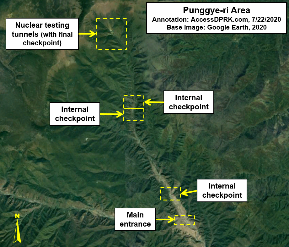
Facilities like Yongbyon and the
Punggye-ri nuclear test site, where substantial nuclear components and functional
nuclear devices are held, take a multilayered approach to security. To get to
the actual testing tunnels at Punggye-ri, one has to travel along several kilometers of narrow road and make it through multiple
checkpoints. If Wollo-ri is where nuclear warheads are either being produced or
stored, only the strictest security measures make sense.
Of on-site housing

Using Kangson as an example, Lewis cites what are likely apartment blocks within the perimeter as evidence that the facility may be part of the country’s nuclear program because having on-site housing (within a walled complex) is quite rare, and Kangson also has on-site housing. On-site housing is indeed unusual in North Korea but most nuclear facilities, in fact, do not have such an arrangement. Neither the Pyongsan or Pakchon uranium milling plants have housing, Yongbyon is a closed city with a defined housing district but no housing within the individual research and production areas, and the Academy of National Defense Science (Sanum-dong) lacks it as well. Other sites may have housing but part of that is due to the expansive size or remoteness of the facilities in question.
To be short, on-site housing at any
facility would indicate it has some level of importance, but it is not a unique
identifier of nuclear facilities.
Another thing to consider is how the
housing relates to Wollo-ri’s potential purpose.
Wollo-ri lacks any obvious substantial
electrical infrastructure which would point to the existence of
energy-intensive industrial activity or to a large underground facility. When
the site at Kangson was constructed, an electrical substation was built nearby
as well to help provide the needed electricity. Lacking its own substation or
major transmission lines, this would suggest that whatever is going on at
Wollo-ri wouldn’t be intense industrial activity or producing large numbers of
parts.
At the same time, there are six
apartment blocks at the facility. I estimate that there are as many as 406
apartment unitsB; each given to a worker and their family. Assuming
some couples work together, let’s make it an even 450 employees.
North Korea’s nuclear inventory has less
than 100 warheads and it is estimated that they can produce no more than twelve
bombs per year at maximum output. The country already possess an industrial
base known to produce a range of electrical components for their ballistic
missiles and other weapon systems, and more dangerous components (like the
explosive lenses) are manufactured elsewhere, so an undeclared production
facility would likely be used in the production of specialty parts. But you
wouldn’t necessarily need 450 employees to produce a handful of small devices
each year.
The monuments
Monuments can be an indicator of the
importance of a facility. Whether it educational, industrial, agricultural, or
military, the type of monument(s) seen at a site can help give a fairly
unambiguous ranking for the place. They can also indicate if Kim Jong Un (or
his predecessors) has visited before.
Wollo-ri possesses two monuments: a
Tower of Immortality and an apparent joint mural of Kim Il Sung and Kim Jong
Il.

Towers are found in every town in the
country and they are dedicated to the “eternal” lives of Kim Il Sung and Kim
Jong Il. They can also be found at universities, factories, and other sites the
regime deems worthy. During my 2019 survey
of North Korean monuments, I found at least 5,175 Towers across the country.

Joint murals are found in county seats
and at even more rarified civilian and military facilities.
In some places you can clearly see the
faces of the Kims through satellite imagery. Unfortunately, the mural view at
Wollo-ri isn’t the greatest quality. But what is obvious is that there are two
images being shown (interpreted as busts of the Kims) and the rest of the
monument’s surface appears to be white. This is indicative of a joint mural.
Unlike the thousands of Towers, fewer than 300 were identified during the
monument survey.
The existence of the mural at Wollo-ri
is important, however, it isn’t a signature of a nuclear facility, even when
combined with the Tower. The headquarters
of North Korea’s air force has at least seven monuments and a joint statue of
Kim Il Sung and Kim Jong Il, the highest honor any North Korean site can be
bestowed. The headquarters also has a defined perimeter and on-site housing.

In the Arms Control Wonk post, it is
claimed that the monuments at Wollo-ri indicate visits to the facility by the
country’s leadership. That is simply incorrect. As I have described, Towers and
joint murals are found in many locations and none are directly connected to
leadership visits, rather, they are daily reminders of the Kim family cult and (when taken in combination) can ascribe a
level of importance to a given site. Commemorative monuments are much smaller
and are typically rectangular blocks of stone with a brief inscription carved
into the surface.
These can be found at many (but not
all) places visited by the Kims. In the event of multiple visits, instead of
having an ever-growing wall of monuments, a museum will be built. This was the
case with Korean People’s Army Farm No. 1116 which has received annual visits by Kim Jong
Un since 2013. Even if visits to Wollo-ri weren’t publicized, the facility
would still be awarded with a monument.
Wollo-ri only has the Tower and mural.
Underground
facilities
In the most simplistic terms, an
underground facility (UGF) could be defined as any useful structure with an
inch of dirt placed on top. However, most wouldn’t consider a root cellar or
simple basement a genuine underground facility. Particularly for the purpose of
secure and clandestine manufacturing or storage, underground facilities are
located multiple meters below the ground if they are placed underneath an
existing building or they are excavated deep into hills and mountains.
North Korea probably has more
identified underground sites than any country on earth. Some are enormous arms production
facilities (like the Kanggye General Tractor Plant, the largest known
underground arms manufacturing plant in North Korea) and others are smaller
facilities used for storage or that sit empty until needed in the event of a
conflict. They are all clearly identifiable once you know what to look for.

There are two hardened structures at
Wollo-ri at the front end of the complex that were built in 2011-2012.
(Coordinates: 39° 3'9.59"N 125°37'8.36"E) Neither is larger than 20
meters wide and there was no evidence of excavation work during their
construction to suggest they cover an underground entrance. Small hardened
structures like these are common enough and are often used to store fuel or for
other benign purposes.
There is also a small trench-like
structure that is barely two meters wide that lies in the northeast section.
(Coordinates: 39° 3'19.82"N 125°37'15.41"E) It does not connect to
any building and doesn’t match the design of any other underground entry point
one can find throughout the country. If it is supposed to be part of a UGF, I
would say construction is just in the initial stages.
Most underground facilities are easy
to spot.
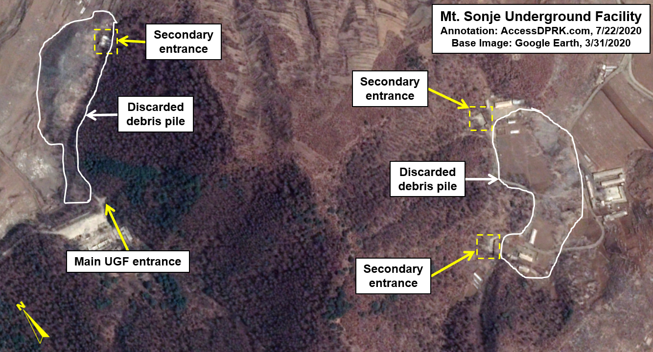
One such facility is between the cities of Pyongsong and Sunchon, beneath Mt. Sonje. It has four entry points and there are piles of debris that were excavated from inside the hill during construction.
In other cases, where a building hides
the entry point, the building is flush with the hillside. None of the main
buildings at Wollo-ri are flush with the hillside. The other buildings at
Wollo-ri could only hide a UGF that was constructed directly beneath them and
there is no evidence of that having occurred. (Construction wasn’t caught on
imagery and no large debris piles are evident.)
In the event where you connect a UGF
to a building that isn’t flush with the surrounding landscape, a connecting
structure is built. A prime example of that is a connecting tunnel that was
built in 2017 and connects a building in the Armed Forces District of Pyongyang
to a massive underground complex. It is approx. 6 meters wide and extends a
maximum of 20 meters to reach the hill. Prior to this connecting structure, the
main entrance, 660 meters away from the newer one, was still identifiable.

Warhead storage
possibility
Lewis’ addition of the description
of an unidentified nuclear warhead storage facility is interesting but there
was nothing in the description that mentioned Wollo-ri or that gave a specific
location. The officials simply said there’s a warhead storage site somewhere.
In terms of storage, there are other more suitable places suspected of being
warhead storage facilities, including one near the city of Kusong.
And when looking at known warhead
storage sites around the world, a few trends become clear. Namely, very tight
security and underground storage. The largest warhead repository in the world
is the Kirtland Underground Munitions and Maintenance Storage Complex in the
scrublands around Albuquerque. The underground portion alone covers roughly
57,000 square meters (not including the potential for multiple levels).
It has a single entry point, it is surrounded
by fencing, and has three watchtowers. Plus, it is situated in the middle of a
larger military complex.

Turkey’s Incirlik Air Base is another place that houses American/NATO
warheads (up to 50). They are stored underground in the center of the air base
which is the most secure area.
The lack of any identifiable
underground facilities at Wollo-ri, its questionable security, and the lack of
any direct mention of the site specifically as a storage facility leads me to
conclude that while it may have a role to play in North Korea’s nuclear
program, the probability of it being a warhead storage facility is almost zero.
Adding to that assessment are the additional facts that Wollo-ri is located far
away from any long-range missile bases and the fact that it is located just a
few miles of an elite section of Pyongyang.
In order for North Korea’s ballistic
missiles to be a credible threat, they must be near the warheads. Wollo-ri is
nearly 70 km away from the nearest known ballistic missile base and that
journey would take hours across miles of winding road and rail – an easy target
to destroy.
And while North Korea does have a
habit of meshing military and civilian areas together, any direct hit to a
nuclear storage site would spread radioactive material across a wide area
thanks to fire and wind currents, contaminating the city with highly enriched
uranium and/or plutonium (depending on the type of weapons stored there).
Political University?
I’d like to briefly discuss an
alternative explanation put forth by an alleged North Korean official. He claimed
that the facility is actually the “Pyongyang Anti-aircraft Unit Command’s
Political Military University”. I and many others deeply question this
explanation. There is a state security academy nearby at 39° 2'39.39"N
125°38'1.49"E, and it and all of the other known political and security
schools follow a very specific pattern. Wollo-ri does not comport with that
pattern and deviates from it in a number of ways. While I am not convinced that
Wollo-ri is a nuclear-related facility, I reject the assertion that it is a
mere political university.
Conclusions
While there aren’t any other “unusual”
facilities around Wollo-ri that could instead be the nuclear facility, the
evidence provided for the site in question, in my estimation, doesn’t rise to a
likely probability – particularly when it comes to the question of it being a
warhead storage site. The specific parts of Wollo-ri described are common to
many other facilities (military, industrial, and educational), and it seems the
claim rests largely on the book mention, for which other questions need to be
answered before having the confidence to connect the intelligence assessment
with this specific location.
Even when looking at all of the
signatures discussed on the Arms Control Wonk post in combination, the
perimeter, housing, monuments, etc. they don’t add up to a unique identifier.
To demonstrate this, one need only look at the Samchon Fish Farm (which
underwent an expansion in 2019). It, too, has a security wall, on-sight
housing, multiple monuments, and it also has its own electrical substation and
a water supply system that is partially underground.

But back to Wollo-ri. As a village it is unassuming, so the Wollo-ri facility certainly sticks out among the structures surrounding it. It just doesn’t stick out in any specific manner. There are also less conspicuous (aka not unusual looking) military facilities in the area, some that include underground sites, that could theoretically serve as a production site. (The underground facilities at the Panghyon Aircraft Plant are thought to have played an early role in the country’s enrichment program.)
Last note
On a personal note, I have never
openly debated the analytical work of anyone before, so I want to take a moment
to address this. Lewis and the other experts who took part in analyzing
Wollo-ri are brilliant. That’s rather self-evident when you look at each of
their careers. I am not saying they are wrong, rather, I disagree with the
conclusions drawn based on the evidence presented.
Wollo-ri is a “puzzle” in certain
ways, as David LaBoon told me, and I agree with that. The fact the village has
been mentioned in connection with the country’s nuclear program by an
intelligence official is intriguing, but the facility’s aspects are vague, yet
also show importance. Importance to what is the question.
As interest in North Korea grows and
the tools available for open-source intelligence improves, the body of work
relating to the country has exploded (pardon the pun). Having an open dialogue
about differing analysis creates a fuller and more nuanced picture and serves
to better inform the public and policy makers going forward.
Footnotes
A.
1.
Shin Jong-woo of the Korea Defense and Security Forum said,
"It may be a facility for another military purpose, not for nuclear
warhead development."
2.
Olli Heinonen, former deputy director general of the International Atomic
Energy Agency (IAEA) told Voice of America that there is little possibility that there
is a nuclear facility around Wollo-ri and that, “the report does not provide
clear evidence that the facility is nuclear-related.”
3.
A report
by the Korean Broadcasting Service also noted, “South Korea’s military and
intelligence authorities have dismissed a CNN report that said activity
suspected of being nuclear warhead production.”
B. There are five apartment buildings in a cluster and a likely sixth (that’s of a different layout) near the southern end of the facility. Each building is seven stories tall. Estimating the first five buildings have 10 apartment suites on each floor, that comes to 350 units. And the sixth building has eight suites or 56 units for the building. That totals 406 apartment units. Depending on the actual layout of the units, there could be fewer or substantially more.
I would like to thank my current Patreon supporters: Amanda O., Anders O. GreatPoppo, Kbechs87, Planefag, Russ Johnson, and Travis Murdock.