Sunday, November 15, 2015

North Korea's Air Force & Airports

NOTE: Scroll to the bottom to download a Google Earth KMZ file of all airfields and heliports.


Introduction

The Korean People's Army Air Force was created in 1947 and is one of five branches of the Korean People's Army. Today it has around 1,000 aircraft with 110,000 personnel. Given the military primacy system (Songun) of North Korea, we might as well consider domestic and military aviation controls as one and the same.

The KPAAF is currently divided into six divisions: 1st Air Combat Command (HQ at Kaechon), 2nd Air Combat Command (HQ at Toksan), 3rd Air Combat Command (HQ at Hwangju), 5th Air Transport Division (HQ at Taechon), 6th Air Transport Division (HQ at Sondok), and the 8th Air Training Division (HQ at Orang). These are all controlled by the central Air Defense and Combat Command which is headquartered in Chunghwa, Pyongyang.

(As always, click on the pictures to see a larger view.) 


Combat air divisions consist of four to nine air regiments, service and support units, and have approximately 160-300 aircraft.
They are organized into a headquarters and division command post, three to six fighter regiments, one bomber regiment, one to two helicopter regiments, five to seven anti-aircraft rocket brigades (SAM brigades), communications center, radar regiment, nuclear-chemical defense battalion, engineering battalion, transportation battalion, guard battalion, and a maintenance and repair unit.

The overall combat readiness of the air force is low, ranging from 50% to 70%. Due to ongoing fuel shortages and lack of repair equipment/parts, training flight time is usually less than an hour and generally consists of take-off's and landings.

Airfields

The country has a total of 99 airfields and heliports. There are 12 main airfields, these include the six divisional headquarters, Pyongyang International Airport, Wonsan Airport, and others. There are 14 highway strips which are widened lengths of road used to serve as emergency runways in the event of war or other crisis. Of all the airfields, 20 are basic grass landing strips, 33 are paved, and 19 are heliports or single helipads. Ten of the known airstrips that still exist are also either fully abandoned or severely neglected. One thing I find curious, is that Chagang Province only has one airport, at Manpo. Chagang is a key military manufacturing region with otherwise limited infrastructure (it only has two domestic access points by rail).

This shows the locations of all the airfields. The plane icons are for planes, helicopters for heliports, and the divisional headquarters are shown larger.


Improvements

Over the last few years there have been a number of improvements/expansions made to existing airports, and a few new ones have been constructed as well.

Located about 12 miles from the heart of Pyongyang, North Korea's only official international airport (Pyongyang-Sunan International) underwent renovations and the expansion of its terminal.

The following pictures are of the terminal before and after primary construction was over.


Another facility in Pyongyang to undergo improvements was the VIP heliport in downtown. Situated along the bank of the Taedong River and among elite neighborhoods, the original heliport was completely demolished and new one was built next to the old site.

Former heliport
New site

Moving across the country to the east coast city Wonsan, we find North Korea's newest (as of yet unofficial) international airport - Wonsan Airport. With Kim Jong-un's approval, starting in 2013 the airport underwent an extensive remodeling with the intent of enabling the development of a planned "Wonsan-Mount Kumgang Tourist Zone". The airport project is estimated to have cost $200 million. If true, that would represent over 1% of the country's entire economic output. For some perspective, 1% of America's GDP would be $170 billion.

Each year North Korea receives around 100,000 visitors, Wonsan's new capacity is 1.2 million. The original plan for Pyongyang's expansion was to accommodate 12 million!

Here's a side-by-side comparison of the before and after.


There have been two new airports built in the last few years. There's a new Kumgang Airport (which is still not operational) that I wrote about in March 2015, and also in 2015, North Korea built a small paved airfield next to the International Friendship Exhibition.

Here is the unused Kumgang Airport which replaced the grass Kumgang landing strip.


Google Earth File

I have been able to pull from different sources (not to mention the fact I've literally looked at every square mile of North Korea) and was able to put together a Google Earth KMZ file. It contains the locations of all 93 existing current and former airfields/heliports, along with a visual count of all aircraft seen, and additional information/links for certain airfields. To explore the file you will need have Google Earth.

To automatically download the file from my Google site "AccessNorthKorea", just click THIS link.
To check out the site first (not much there yet) you can visit it here. The file name is "AirportsAirbases-updated-12-1-15.kmz".

Further Reading

Korean People's Air Force, Wikipedia article
North Korea Air Bases, Federation of American Scientists
Korean People's Air Force, Wikileaks document


--Jacob Bogle, 11/15/2015
www.JacobBogle.com
Facebook.com.JacobBogle
Twitter.com/JacobBogle

Sunday, September 27, 2015

Taedong River Pollution

(Taedong River as seen from the Juche Tower in Pyongyang. Source: Commons)

The Taedong River is North Korea's second longest river and it flows through the heart of the country, bisecting Pyongyang and eventually discharging into the Yellow Sea. Despite serving as the main source of drinking water for the nation's capital of nearly 3 million, the river is heavily polluted.

North Korea has adopted ten major environmental laws (as of 2005) and, as in many areas, pays lip service to environmental protection. However, the country has one of the world's worst environmental records. Even though the destruction of the environment, like deforestation, has directly contributed to famine, flooding, and loss of life, the country's economic desperation has led them to continually ignore the environment in favor of industrial and agricultural activity. According to CSR Asia, by 2005 North Korea was releasing 10.8 million tons of air pollutants.

The Taedong estuary is the recipient of the bulk of the pollution released into the river. This is made even worse by the West Sea Barrage (completed in 1986) which prevents natural and adequate removal of pollutants. And thanks to a lack of necessary water treatment plants, the river has "an average chemical oxygen demand of 2.15 ppm in 2008, falling behind the environmental standard of 3 ppm." Industries along the river also dump as much as 30,000 cubic meters (over 1 million cubic feet) of polluted water a day directly into the Taedong. The estuary isn't the only place where river water ends up. A massive system of irrigation canals instituted in 1989 means that thousands of acres of farm land receive water from the Taedong, with crops (and eventually the humans that eat them) taking up the various toxins left behind.

North Korea's two largest coal-fired electrical plants lie along the Taedong. The Pukchang (also spelled Bukchang) Thermal Power Plant, located 6 miles east of the Kaechon internment camp in South Pyongan Province, is one of eight major coal-fired electrical plants in the country. It has a capacity of 1.6 GW (twice the capacity of America's Three Mile Island Nuclear Plant) and is the largest of North Korea's power plants. However, the reality on the ground is that Pukchang's output may be less than one third of it's designed capacity. Regardless of production, the plant still releases vast amounts of pollution into the air (over 6 million tons of CO2) and river.

From 2005 to 2007 the country embarked on a new construction program: cut off a 3.4 mile long portion of the Taedong River and turn it into a massive pool of toxic sludge.


Previously, waste from the Pukchang plant was diverted into two smaller bends of the river, seen as the flat areas at the top and center-right of the loop. These coal ash basins were not fully separated from the river and during heavy rains pollutants would wash into the Taedong. This new, much larger waste basin was created when a neck of land (left side of image) was cut, the rock being used to build makeshift retention dams.

Sludge deposits seen filling up the old river channel.

Dam failure is a well-known threat in North Korea and many smaller earthen dams (like this new retention dam) are routinely overtopped, particularly during heavy rains. Not only would that release large quantities of surface waste into the river, but it further weakens the dam and can cut channels into it, making future failure easier. Beyond the risks associated with overtopping, coal ash sludge contains large amounts of toxic materials and heavy metals. Lead, cadmium, arsenic, and even radioactive thorium and uranium - which occur naturally - are concentrated during the coal burning process and are then discharged into this basin. Lacking adequate barriers, this material will slowly seep into the river and result in a continual source of pollution for years to come.

In a touch of irony during the construction of this new basin, a small hydroelectric generating station was also built. It's located where the land was cut and takes advantage of the river's new, slightly shorter course.

Additional Reading
Inside North Korea's Environmental Collapse, by Phil McKenna, NOVA/PBS 2013

--Jacob Bogle, 9/27/15 (updated on June 30, 2017)
Facebook.com/JacobBogle
Twitter.com/JacobBogle
www.JacobBogle.com 

Saturday, August 15, 2015

Kaechon Hydroelectric Dam Under Construction

North Korea has struggled to solve its electricity problems for decades, particularly since the country lacks native supplies of heavy fuel oil. The handful of coal fueled power plants strain to supply large cities and industry and blackouts are common, even in the capital. North Korea does have a fairly abundant renewable resource, and that's water. Despite suffering from major floods and the occasional drought, the country does seem to be betting on (at least in part) hydroelectric power - which has the added benefit of flood control.

Over the past 10 years, dozens of large and small hydroelectric projects have been initiated. One can find small "micro" hydroelectric generating stations that are meant only to feed a village or factory scattered all over the country, and then there are the large-scale projects, like Huichon, that's expected to keep Pyongyang in lights.

There are also medium-scale hydroelectric projects being built. One such dam is located near Kaechon in South Pyongyan province (although it's across the border in North Pyongan). It is located less than 2 miles from Kaechon Airbase and 9 miles east of the Yongbyon Nuclear Reactor site.


Construction likely began around the end of 2013, although the earliest imagery available is April 2014. Based on the image below, the plant will have 3 electric generators.


--Jacob Bogle, 8/15/15

Saturday, July 11, 2015

The Rise of Cell Phones


The government of North Korea has been experimenting with allowing and expanding mass communication for over a decade. Prior to 2002, mobile communications had been limited to top government and military personnel. Cell phones were then introduced for public consumption and by the following year some 20,000 North Koreans had cell phones. Although the system has always (technically) limited usage to in-country calls, there have been a few hiccups along the way and the government has been playing catch up ever since in an attempt to limit outside information leaking into their formerly hermetically sealed country, and to keep undesirable internal information from spreading throughout the nation.

Despite the initial success in 2002 and 2003, the service was suspended in 2004. The reason for that suspension and the confiscation of phones was an explosion at a train station that, allegedly, was targeted at killing Kim Jong-Il as he passed through the area via train. The bomb was triggered by a wireless device. It wasn't until late 2008, when the Egyptian telecom company Orascom negotiated a contract with Pyongyang, that cell service was reinstalled. This new 3G service, officially called Koryolink (75% owned by Orascom and 25% by the North Korean government), initially had fewer than 1,700 customers its first year, but now serves over 2 million people (about 8% of the population). The country has a 2G provider, SunNet, that services Pyongyang, but little else is known about it.

Under Kim Jong-un, the number of cell towers has risen sharply. I've mapped around 360 cell towers across the country so far, and I estimate there will be a total of 550 to 600 by the time I'm finished. For some perspective, the US state of Tennessee has more cell towers than the whole country of North Korea. If they were all evenly distributed, that would mean 30% of the DPRK's land area would have some kind of cell coverage. In reality, most major and medium sized cities do have at least one cell site nearby, meaning that the majority of citizens resided in an area with some cell coverage.

Cell phone usage is still heavily regulated though. Not only does an individual need permission to have a phone, calls are routinely monitored, and service can be cut at any time, particularly during disasters or various crisis. The government has embarked on erecting signal jammers/interceptors, particularly along the border regions, and has a fleet of vehicles that randomly sweep areas in an attempt to catch people calling out of country.

The rise of cell phones has greatly contributed to the country's burgeoning market economy and enabled a true middle-class to emerge. A substantial black market has also arisen associated with cell phone acquisition: cutting through red tape etc. with people using bribes, intermediaries, and "buying" the names of impoverished people (paying them in food or small amounts of money) so that others can use the name in an attempt to get around regulations.

Phone prices range from $150 to $700, which is no small purchase in a country where per capita GPD is a mere $1,800/year. Phone plans offer 200 minutes for a small fee, but after that the price can be as much as $10 for an additional 200 minutes. Naturally, a used phone market has developed. Even though the phones can facilitate business, many people still struggle to afford additional minutes.

Most phones are of Chinese origin, though party cadres and other wealthy individuals can afford LG and other western phones. In 2013 North Korea unveiled their "domestic" Arirang touch-screen phone, however, many experts believe it is simply a knockoff Google Android design and is manufactured in China.

Kim Jong-un inspecting packaged Arirang phones.

While the phones are predominately used for business, keeping in touch with friends, sending pictures, and other normal things, the government does have the ability to use the phones to spread state propaganda by sending text messages to all subscribers. There have been reports that data transfers (like sending pictures) are now tightly controlled and in some cases that ability is no longer included. Random police checks also occur frequently. The government is also trying to promote a new phone model, the "1913", which limits the phone's use to the city of its registration. SD card slots are blocked, and internal memory is drastically limited compared to other models.

When Koryolink was first introduced, many observers hoped that it would herald a new era of openness and that it might even lead to regime change. Eleven years later, while there have been improvements when it comes basic communication and market activity, the government has been effective enough, along with the service's cost and inconsistent quality, as to render those hopes little more than dreams for some future time. Using phones to even set up a soccer club resulted in sending 20 college students to do hard labor.

And though word of rumors, scandals, and disasters can now travel across provincial borders and in rapid time, the other systems of government control make any type of organized or mass resistance nearly impossible.

For the government, cell phones enable better communication between departments, improved control standards when it comes to production and agriculture, faster responses in the face of emergencies, and the added benefit of hard currency thanks to a growing economy (even if much of that money comes from bribes and corruption), and hundreds of millions itself from the establishment and expansion of cell service.

Here is a map of the towers in Pyongyang and surrounding provinces:


And in the northeast of the country:


For more information, check out this report published by the US-KOREA Institute and Voice of America about the rise of mobile phone usage in North Korea and its possible political implications.

Also, see North Korea News for the article "Inside North Korea's Cell Network" featuring former technical director of the network, Ahmed El-Noamany.

---Jacob Bogle, 7/11/2015
Facebook.com/jacobbogle
Twitter.com/jacobbogle
www.JacobBogle.com

Friday, April 10, 2015

Mapping Progress Update #6

It has been nearly a year since my last full update on my progress on mapping the whole of the country, and progress has been great.

A year ago, I had mapped 10,000 sq. miles, or 21.48% of the country and I had around 5,500 military, domestic, economic, and propaganda places marked. It took me around a year to get to that point (remembering of course that I wasn't doing this every single day, and I'm still not always able to work on this).

Today, I've mapped out 26,137 sq. miles (56.15%) of the country (which is 46,541 sq. mi. in size). Of that, 8,219 sq. mi. has been mapped just since the start of 2015. My productivity has greatly increased since I decided to set a completion date: Dec. 31, 2015. And that includes combining my finds with the extensive original work of NKeconomywatch and Google Earth user "Planeman_".

To finish this year, I need to map an avg. of 78 square miles a day. So far, I'm averaging 83. That places me 5 days ahead of schedule right now and puts me on target to finishing 20 days early by year's end. Of course, something could happen and my average rise or fall.

As noted in an earlier update, to help with effective mapping, I divided the country into sections covering (roughly) 25 square miles. This map shows each section that I have mapped. The elevation is set so that each dot is 5 miles in diameter, thus, mostly covering the areas I have fully mapped.

 
Click for larger view.

In terms of items marked: 18,657 total items; 3,221 military (inc. DMZ, Airports & Road Blocks), 4,140 monuments, and 11,103 domestic & economic locations. Here are the specific numbers for a few select items: 389 anti-aircraft batteries which represent about 1,900 individual guns, 327 communication/cell towers, 364 electrical substations, and 145 town markets. I've also mapped out hundreds of miles of new roads, main irrigation canals, coastal fences, and border fences.

Included under the "military" heading are, 461 additional places along the DMZ, 140 DMZ related road blocks, and 76 airports, heliports, and aviation test facilities (6 hadn't been located before).

I've also marked all 23 current and former border crossings, twenty of which connect with China. Plus, 159 key mountains & local geographic high points.

Here's a few images to give you an idea of what all I've mapped.

All 76 aviation facilities. Click for larger view.

Electrical Substations of North Pyongan Province. 

Cell towers of Pyongyang. 

North Hwanghae Province's Anti-Aircraft Artillery Sites.

The red dots represent HARTS (Hardened Artillery Sites) in South Hwanghae Province near the South Korean island of Yeonpyeong. On Nov. 23, 2010, North Korea bombed the South Korean island with 170 shells & rockets. Four were killed and 19 injured.


---Jacob Bogle, 4/10/15
Facebook.com/JacobBogle
Twitter.com/JacobBogle
www.JacobBogle.com

Monday, March 30, 2015

Major Landslide in North Hamgyong Province

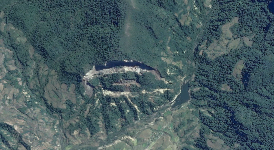
Looking at imagery from Myongchon County, North Hamgyong Province (near the Mt. Chilbo National Park), I found what seems to have been a major landslide.

Due to North Korea's mountainous terrain and frequent floods, landslides are a fairly common occurrence, but this one consisted of a 900 foot high hillside collapsing.

Here's the area on June 19, 2011:


And after the landslide in 2013:


The crest of the hill is 894 feet above the valley floor below. The width of the collapse is nearly a kilometer, at 3,000 feet. It also interrupted normal runoff and thus created a small new lake (right-side of collapsed area). The lake covers about 4 acres (1.6 hectares). The exact coordinates are:  41° 7'33"N 129°30'39"E.

Here's a side view of the area before and after the event:


In June of 2011, there was major flooding in South Korea that also affected parts of North Korea. While it's impossible to tell when exactly this landslide occurred given available information, it's conceivable that the flooding in 2011 played a role.

The Mt. Chilbo area is a very popular tourist destination and is also an important ecological region. According to UNESCO, it holds 16 endemic plant species, 30 endangered plant and animal species, and has 132 medicinal plant species. The geologic origins of the Mt. Chilbo area come from volcanic eruptions relating to the Paektu Volcanic Zone (though, this particular area hasn't been volcanically active for millions of years). 


--Jacob Bogle, 3/30/2015
www.JacobBogle.com
Facebook.com/JacobBogle
Twitter.com/JacobBogle
Saturday, March 28, 2015

Kumgang Airbase Update

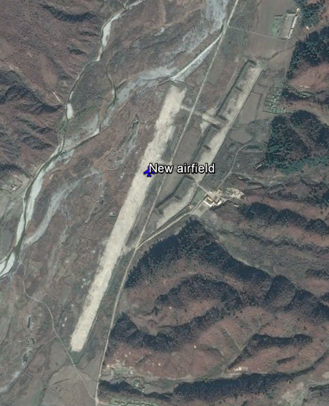
Three years ago, a new airbase appeared in a mountain valley 10.4 miles (16.7 km) west of the city of Chanjon, and 5.3 miles (8.9 km) north of the smaller town of Kumgang, Kwangon Province.

Changjon has had a number of improvements since 2005, including a new golf course, and a renovated harbor. It's also home to a naval base. Of course, Kumgang is nearby the very popular Mount Kumgang park.

The airbase was built between 2010 and October 2012. It has a 3,275 foot (1 km) long single runway and basic support facilities. It replaces the much smaller grass airstrip that once served the Kumgang area.


Here are the exact coordinates: 38°42'5"N 127°59'45"E (link opens Google Maps).

(Click image for larger view)

The facility has several aircraft dispersal pens, bunkers for either storage or maintenance, and 3 small fuel tanks. It will likely be used for civilian purposes, but as it stands, it can be considered primarily a military asset given its structure. 

Despite being fairly new, and the levee built to divert the nearby river (North Korea has built many runways very close to rivers, which doesn't seem prudent), the place seems somewhat deserted and has been flooded at least once.


Also, between 2007 and 2012, the surrounding area saw some upgrades too. A new communications tower was built as well as new housing.


There are no defensive artillery emplacements (that I can find) which typically guard airbases of this size, but there are a few small military units up and down the valley. The town of Kumgang itself, though, is protected by 3 anti-aircraft artillery emplacements which contain a combined 18 guns.

When it comes to completing projects, North Korea can accomplish seeming wonders in a short time (except the Ryugyong Hotel, and the fact that most things aren't built very sturdy), but when it comes to making good use of them, things tend to take a while. 

The newest images freely available date to October 2013 but given that so much effort is being placed on Pyongyang and Wonsan, I don't think the Kumgang area will see much more activity for a while.

--Jacob Bogle, 3/28/2015

Thursday, February 12, 2015

North Korea's Stealth Ship-s

In February 2015, North Korean state media released images of their newest naval asset - a stealth ship.

DPRK Stealth Vessel

Media outlets around the world reported on the "official" recognition of the craft, however there's definitely more than one.

The vessel, which is similar to a hovercraft (something the North Koreans seem to be fixated on), features an angled hull and other features which help to scatter radar. You'll note the similarities in design between the small North Korean ship and the British HMS Daring destroyer seen here:

British HMS Daring

These "surface effect ships" use hovercraft technology to reach high speeds without the need to decrease the weight of needed weaponry.

North Korea has been trying to modernize its military for two decades, but change comes slow to an overly bureaucratic nation severely low on funds. 

The specific ship reported on has been known since 2009, when it was visible on satellite imagery of the Munchon Naval Base (11 miles north of Wonsan).

Ship onshore in Munchon, 2009.

However, after reviewing images from Wonsan (and comparing image dates), North Korea has at least two of these vessels. Both ships can be seen in their respective docks on images dated 10/3/2009.

Wonsan ship. 

The Wonsan ship can actually be seen on images dating as far back as 2002.


This class of vessel is armed with two 30mm automated close-in weapon systems (CIWS) which is based on the Soviet AK-630, four indigenously-designed 14.5mm rotary cannons, a new surface-to-air missile system, plus two mounts for two of the lethal anti-ship missiles. The key weapon system is the Kh-35 anti-ship missile system.

--Jacob Bogle, 2/12/2015
www.JacobBogle.com
Facebook.com/JacobBogle
Twitter.com/JacobBogle