Thursday, February 28, 2013

A Caged Population

UPDATE (8/19/15): Reporting from DailyNK says that North Korea's new border fence with China has been completed in Ryanggang Province. I finished mapping the border fences and I can attest that in the past the fence was indeed incomplete. There were a lot of gaps and areas where it had been cut or otherwise destroyed. Based on available imagery, there are still a lot of areas in the north that lack fencing.

Map of all known border and coastal fences. Click for larger view.
As I said in my previous post, movement in and around North Korea is heavily controlled. Not only are there road blocks, check points, travel document requirements and so forth, there is also a network of fences which ring the whole nation.

These fences were built in earnest during the period of the 1990s famine and range from a simple fence to complex mixes of wire fences, electric fences, sand berms and concrete walls, especially along the Chinese-Korean Border and DMZ. However, much of the northern border fences construction was done on the Chinese side over fears of instability within the DPRK. Portions of the fence are constantly being maintained and upgraded while others are in fairly bad shape.

The North Korean government claims the fences have been built for national defense purposes and to protect ocean wildlife from poaching. Many outside observers say that the real motivation was to keep people from fleeing and to control the fish supply so that the elites and military received food resources first.

This large-scale image shows a green band along the beach. The fences (like the DMZ) have acted like unintentional wildlife preserves since new construction and even wandering around most beaches has been prevented. The first non-border fences were constructed around coastal cities to keep people from sailing off. I will focus this post on the coastal fences since they help highlight the human-rights abuses within the country.


This next image is a close-up of a fence.


Here we can see a fence at a better angle to give you a sense of its height as well as the guardhouse, most of which are located in cities and villages.


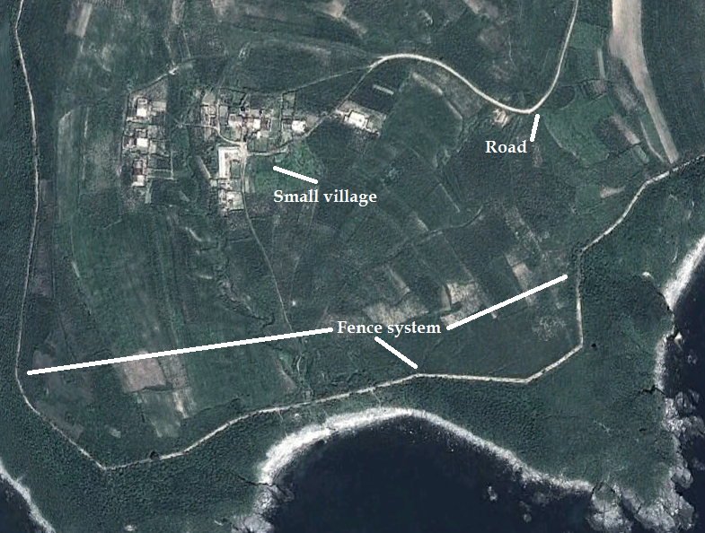
This image is of a small village located on a tiny peninsula on North Korea's northeastern coast. You can see the village is almost completely surrounded.


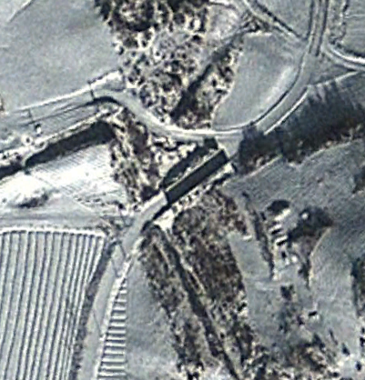
Finally, we have a fence with a small guard-post. Guard-posts are located at varying intervals depending on terrain and the regional population. The fence cuts across a river bed and it appears that section is either not finished or perhaps has been washed away from flooding.


(For updated information and access to the complete fence system via Google Earth, please read North Korea's Great Barrier, Jan. 2018.)

Additional Reading:
http://www.huffingtonpost.com/2012/12/31/north-korea-culture-war_n_2389810.html

--Jacob Bogle, 2/28/2013
www.JacobBogle.com
Facebook.com/JacobBogle
Twitter.com/JacobBogle

Tuesday, February 26, 2013

Road Blocks and Restricted Travel

In the United States and much of the free world, you can travel from town to town visiting friends and family. You can also travel from state to state without ever needing to worry about having travel documents or being questioned by the government. Things aren't so simple in North Korea.

The government controls every aspect of life and freedom of movement simply doesn't exist, except for the ruling family alone. If you want to go to a different city to visit family - you need travel papers. If you want to stay the night - you'll need additional approval. The country is filled with checkpoints and road blocks, especially as you make your way toward important cities, factories, and even the beach.

Road blocks typically consist of a series of large concrete blocks perched on top of a ledge so that they can be felled within moments and prevent an invading army from advancing...or to keep the people boxed in. Most of these road blocks are along the DMZ with South Korea (who has their own version of them) and so that can be understandable. After all, the two countries are still technically at war. Unfortunately for the citizens of the north these road blocks aren't confined to the border. There are also a number of them throughout the country, guarding mountain passes, on roads leading to the coast and at times in random places with no discernible justification.

Then you have the myriad of checkpoints. These are little more than a gate with a small guardhouse. Although they may not provide any resistance to an army on the move they do help to enforce the people controls that mark much of like in the DPRK. You can find them scattered everywhere but especially near factories, other important sites and the beach (to keep people from simply fleeing).


This image is of one such road block near the southern border. As you can see, these are very large blocks that would easily block a road for quite some time.

The image below is a sample region immediately adjacent to the DMZ on the North Korean side. Each icon represents a road block. There are hundreds of them over the course of the full 160 mile long DMZ.


Here are some examples of road blocks as seen from satellite imagery:


You can see a series of small squares on either side of the road. The line moving vertically is a double fence. This road block is accompanied by a guardhouse and military unit with a series of trenches cut into a small hill on the upper left. 


And in this image taken during winter you can clearly see the shadow cast by the road block. 

Below is an example of a gatehouse which guards an expansive area containing coal mines and other industrial buildings. You can see two small trucks lined up to leave the area.


Finally, we have a road block on a beach. This is part of an extensive network of gates and fences which will be the subject of my next post. People must check in and out in order to simply go out and fish (notice the small fishing boats on the tidal mud flats).


--Jacob Bogle, 2/26/2013

Sunday, February 24, 2013

Mapping Project Update 1

In 2005 Mike Ane started a file containing several hundred locations of interest and then in 2007 Curtis Melvin and his associates at www.NKeconWatch.com greatly expanded the file by mapping the economic, cultural and military sites of North Korea using Google Earth. Their work brought to light thousands of locations and their KMZ file has been downloaded well over 151,000 times. However, as I would look over the country, I would spot something they had missed, and then it dawned on me that no private citizen (to my knowledge) has ever gone through the whole of North Korea, literally square mile by square mile, and marked every single item of interest.

So, a few months ago, I decided to take on that challenge. The work of Curtis and another avid GE user ( "Planeman_") laid the foundation and their descriptions taught me a lot about what places look like. For example, what an anti-aircraft artillery site looks like from aerial imagery, what an electric sub-station looks like, monuments, train stations and so forth. Building on that knowledge and what I have learned through hundreds of hours of research, I have been able to mark thousands of new places without duplicating the findings of others. 

This has been and continues to be a tremendous undertaking, but I think it is very important to shed light on a country so few know anything about. Even since Google Maps began, there was always a black hole in their data - North Korea - and it wasn't until a few weeks ago that Google began filling in the blanks, largely thanks to the work of individuals submitting information. It is my hope that in time North Korea opens up as a country, but until that time comes, I consider it worthwhile to use technology to reach out from my computer to data gathered from space and pull North Korea (or at least what I find) out of the void and bring it to the world. 

North Korea is divided into 9 provinces, 2 special cities, and the capital district. There is also the DMZ (Demilitarized Zone) which I count as its own geographic division. Each area has its own file which is then subdivided in categories: Military, Monuments and Domestic. Each category may have further sub-categories such as: Sub-stations, Irrigation control and Dams, AAA sites, Road & Rail Tunnels etc. I have been making use of the placemark icons and try to make them self-explanatory and use one icon for each different type of location to avoid confusion.  

The image below is a screenshot of all the places I've marked (excluding completed areas). Obviously, it looks like a mess and you're only seeing a handful of individual sites since they're all piled on top of each other, but I think it gives you some idea of what I've been doing and talking about for so long. 

(click for larger)

I have started files on almost every area and completed the DMZ, the Rason Special City and Ryanggang Province. It is my intention to publish the files once I am closer to completing the project, although I may publish what areas I've finished sooner. 

With completed divisions and the portions of partially completed divisions combined, I estimate that I am 25% finished and have marked roughly 2,200 items. The completed areas cover nearly 6,000 sq miles of territory out of NK's total land area of 46,541 sq miles. Due to the lower quality of some of the data there will be portions that have very few placemarks simply because the resolution is so low that specific individual items can't always be identified.

--Jacob Bogle, 2/24/13
www.JacobBogle.com
Facebook.com/JacobBogle
Twitter.com/JacobBogle

You can use the hashtag #AccessDPRK when discussing on social media.

Saturday, February 23, 2013

Propaganda from Space

If North Korea had a state religion the "Art of Propaganda" would be its bible.

Propaganda in North Korea is everything. It is spewed from the mouths of teachers from your first year in school all the way to college professors. It comes from every TV and radio station (all state owned), every newspaper and magazine (likewise state owned) and is plastered across the landscape. There are an estimated 50,000 statues and murals dedicated to Kim Il-sung, and Kim Jong-il and they are placed in even the most remote locations. There are also countless signs that are splashed along the sides of hills and mountains, on the sides of roads and peppered throughout city streets. A large number of these are so large they can be seen from space.

The signs often promote the "strength and prosperity" of the nation or extol the virtues of the country's leadership. From time to time they call on the people to work harder, exceed quotas, raise better crops and obey without question the orders of the Worker's Party of Korea.

Here are a few examples: "Let us march forward with the tactics of the three generations' revolution!", "Long Live the Juche Ideology!", "What the Party decides, we shall do!", "Unite as with one mind", "Let's make our own rebirth!" and "Let us plant more trees!" among many, many others.

(click for larger views)

This one was located at a mine. Each slogan is around 100 feet long and are carved (and painted) into the hillside. I haven't been able to find a translation for this.


This is an example of the type that can be seen along the hillsides of nearly every town and village. Due to its angle it's impossible to know for sure what it says. The slogan is 400 feet long.


Military bases are not immune. This sign is 700 feet long. 


And finally, we have a sign 1,800 feet long with each letter being 200 feet tall. This one was built within the last year along a hillside next to a brand new, massive, hydroelectric plant. It says, "Long live Songun Korea's General Kim Jong Un!". Kim Jong-un is the current leader of the country and the grandson of its founder.

Here is a site with many more similar signs as well as translations for several of them: http://freekorea.us/north-korea-faq/signs


--Jacob Bogle, 2/23/2013

Wednesday, February 20, 2013

New Missile Test Site

North Korea has been interested in developing nuclear weapons since the 1950s. Prior to the collapse of the Soviet Union, the North was able to receive large amounts of financing and technology to pursue their nuclear agenda. However, when the Soviet Union fell North Korea also entered into a period of devastating famines and economic ruin. Despite this the government, under the policy of Songun (military-first), continued to funnel as many resources as they could into their weapons program at the expense of the population's well-being. Today, they still suffer from chronic food shortages and their economic capacity is far smaller than in the 1980's but they have managed to spend billions on nuclear and ballistic missile technology.

Their 3rd nuclear test was on February 12, 2013 and had a suspected yield between 12-21 kt (similar to that of the bomb dropped on Hiroshima). The test was conducted underground in the northeast of the country and registered as a 5.1 magnitude earthquake. This test came a few months after a successful launch which the international community agrees was actually a long-range rocket test in the guise of a domestic satellite launch.

North Korea is one of the most militarized countries on Earth and the landscape is littered with military sties ranging from small outposts to massive secret bases. One of these bases is a missile test site, the Tonghae Satellite Launch Site, seems to be growing. It is located on the coast of the Sea of Japan (East Sea of Korea) and is surrounded by small villages and rugged terrain.

The site has multiple testing facilities and rocket stands. I seem to have found a new test stand in the process of construction. The image below shows you the site in 2010 (left) which is nothing but empty ground and the image on the right is from 2012. As you can clearly see, there is a large structure being built. The layout and design is indicative of a new test stand.

(click for larger image)
Coordinates: 40° 51' 29.47" N 129° 41' 11.56" E

Only time will tell what will happen with this new site, but if the past is any indicator North Korea is well on its way to advancing their missile technology with no signs of slowing down. 

--Jacob Bogle, 2/20/2013