Sunday, July 12, 2020

Mystery at Pyongyang Security Ministry

In 2020 the People's Security Department (aka Ministry of People's Security) was renamed the Ministry of Social Security. The MSS oversees a number of functions including police, prisons, assists in securing the distribution of food, and aides other security agencies.

It is one of the three "pillars" of DPRK state security. The other two are the military and the Ministry of State Security.

One of their facilities, according to the 38 North Digital Atlas, is this complex on the western outskirts of Pyongyang. Its coordinates are 39° 3'10.50"N 125°40'14.21"E. Landsat/Copernicus imagery suggests this facility was built ca. 1989-1992 but the satellite resolution is low enough as to make a fully certain date range difficult.

In recent years, an underground complex has been constructed. Underground facilities (UGF) are not rare in North Korea, but this one consists of a "cut and cover" tunnel - not one that is excavated into a hill but where a trench is dug, the tunnel structure built, and then the site is covered over to hide it. Identifiable examples of cut and cover tunnels are indeed rare in the country.

The exact purpose of this tunnel/underground facility is a bit of a mystery, but considering its location, I feel that detailing its ongoing construction history is important.

General outline of the complex.

The two sections of the complex are joined by a tunnel that runs beneath the central hill dividing the site. The tunnel is approximately 188 meters in length.

The tunnel allows vehicles quick access to each side of the complex without having to go around the hill. The facility has undergone many changes over the years, but this tunnel has existed since at least 2000.

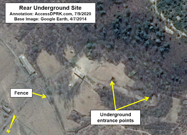
At the very rear of the complex is another underground site. Whether or not it is directly connected to the Ministry complex isn't known but its proximity is interesting.


A trench has existed at the left-side facility since at least the year 2000 and implies that plans for this new underground structure have been around for a long time.

The trench excavation runs about 205 meters long and averages 12 meters wide.

Little else changed at the site until 2013 when several temporary buildings were constructed near the trench, and minor work at the upper end of the trench can also be seen. (Clearer images of this work come from 2014.)

Image showing construction activity in November 2013.

By September 2014, the upper portion of the tunnel is taking shape and a new building had been constructed at the site they were leveling off in 2013.

In 2014 other changes become visible including the addition of multiple permanent buildings (some were still under construction at this time).


By this time, it's clear that a tunnel had been excavated, the sides of the trench had been shored up, and the debris pile shows activity. It isn't known if this tunnel goes into the central hill or connects to the road tunnel between the two sections, but if you draw a straight line following the new walls of the trench, it does intersect with the existing road tunnel.


This at least theoretically gives the possibility that the entire central hill is actually a large underground facility that now has three points of access: the original road tunnel, the new tunnel under construction, and the older rear UGF. This part is merely speculation but the possibility of a large hidden facility is very interesting, as we know that numerous underground facilities exist in North Korea including some that are used in training security forces to hide their clandestine activities.


By April 2017, a concrete structure (or "box") can be seen inside the trench. At this stage, it is approximately 40 meters long and 5-6 meters wide. Additional work around the area to prepare for more construction has also taken place.

On the image dated October 26, 2017, it becomes clear that the concrete section from April was just one small part of a larger concrete tunnel structure that is now 155 meters long and about 10 meters wide.


This type of structure is similar to long military "drive thru" bunkers that exist throughout the country (at least 400 exist at last count). One such example is this bunker, also in Pyongyang, that is similarly divided into two segments and is 10-12 meters wide. It is approximately 190 meters long. These structures are typically used to house and protect various vehicles.


However, these other drive thru bunkers are usually seen as part of military bases and never as part of building construction, making this Ministry structure unique as far as I am aware.

By April 2018, the tunnel had been covered and the area leveled off. The foundation of a new building had also been dug at the north end of the site.


Fast forward to the end of 2019 and the new building has been completed and an entrance site to the tunnel was nearing completion (final touches, landscaping, etc.) By November, another foundation can be seen. The new foundation is in the middle of the construction site and sits on top of the tunnel.

Based on the most recent Google Earth image, there is vehicle traffic going in and out of the tunnel. The square foundation has also had some additional work.


On the above March 13, 2020 image, you can see a driveway leading into the new foundation. The angle doesn't allow for this to be a second entrance into the main tunnel. The whole area has been raised above the tunnel, however, allowing for a low/shallow basement to exist at the new building site. This most likely where the driveway is going.

More recent satellite imagery (that I am not free to share publicly) shows that construction at the site is slow but ongoing. Unfortunately, it doesn't provide further clues to the site's purpose.

Lastly...

While not associated with this site at the Security Ministry, there is another underground construction that likewise began in 2017 and consists of a main tunnel structure. Its coordinates are 39°11'38.26"N 125°45'14.04"E, or 1.8 km north of the Kim Jong Il People's Security University in northern Pyongyang. The tunnel entrance is 12-13 meters wide and it has no apparent exit point.


I would like to thank my current Patreon supporters: Amanda O., Anders O., GreatPoppo, Kbechs87, Planefag, Russ Johnson, and Travis Murdock.

--Jacob Bogle 7/11/2020
AccessDPRK.com
JacobBogle.com
Facebook.com/accessdprk
Twitter.com/JacobBogle

Friday, July 3, 2020

Largest Hydroelectric Project in DPRK Heads Toward Completion

North Korea is no stranger to mega projects. The May Day Stadium (largest seating capacity in the world), Ryugyong Hotel (the abandoned "hotel of doom" that would have been the tallest in the world back in 1992), and the West Sea Barrage (an 8-km long dam across the mouth of the Taedong River) all bear witness to North Korea's willingness to expend enormous resources on enormous projects, even if they don't always work out as planned.

One such current mega project is the Tanchon Hydroelectric Power Station.


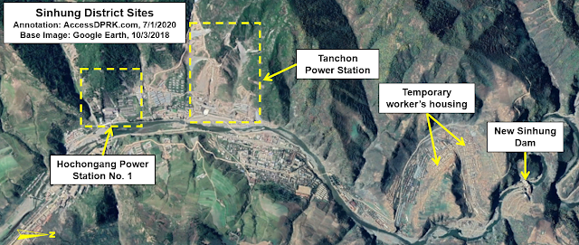
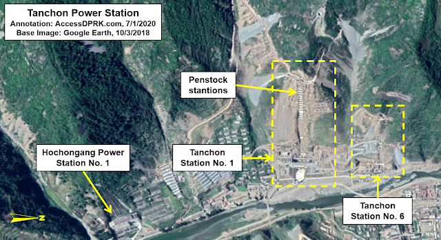
Despite being named for the coastal city of Tanchon, the project centers around the border area between Ryanggang and South Hamgyong provinces, specifically around the worker's district of Sinhung, 53 km away from Tanchon as the crow flies. However, this isn't a run-of-the-mill hydroelectric dam. It is a massive complex that starts at a new water intake point at the Samsu Reservoir (near Hyesan) and then carries water through a roughly 60 km-long tunnel to the electricity generating stations in Sinhung. The tunnel is the longest such tunnel in the country and makes this the largest hydroelectric project currently underway by North Korea.

The next longest water tunnel for hydroelectricity that I am aware of is the Songwon Dam tunnel. Constructed in 1987, it runs a mere 42 km.


The Tanchon project is actually part of a larger attempt to take advantage of the rivers and steep valleys of this region. The northerly-flowing Hochon River is the primary source of water. The northern extreme is the Samsu Dam and reservoir, which lie less than 10 km from Hyesan and the Yalu River border with China (into which the Hochon empties).

In this complicated image you can see the path of the Hochon River (blue), flowing south to north. That water fills the Samsu Reservoir where the water intake site is located for the Tanchon project. That water is then diverted through a tunnel (white) where it travels north to south (against the natural gradient of the area). It will then enter the dual Tanchon generating stations in the small town of Sinhung. From there, it empties into the Namdeachon River (yellow) which flows north to south and empties into the sea at the city of Tanchon.

Moving south (aka upriver), lies the Sachophonyg Reservoir which feeds the Hochongang Power Station in Sinhung (11.8 km away and is adjacent to the new Tanchon generating stations). Both the Hochongang Power Station and the new Tanchon stations empties the waters of the Hochon River into the Namdaechon River, across a sort of continental divide thanks to the tunnels, as the Namdaechon then runs south and empties into the Sea of Japan, whereas the headwaters of the Hochon arise in the Hamgyong Mountains (also known as Gangbaekjeonggan) which create a natural border between Ryanggang and South Hamgyong provinces.


Being built at the same time as Tanchon is a smaller hydroelectric dam on the Hochon at Saphyong-ri (pictured above) and a hydroelectric dam at Sinhung (also called Power Station No. 5) on the Namdaechon River that is less than 2 km from the new Tanchon generating station.

Exploiting this riverine resource goes back nearly a century. During the Japanese occupation era, Yutaka Kubota (founder of the Japanese engineering firm Nippon Koei) was a consultant for the Hochongang River Overall Project from 1925-45, and the project was expected to eventually generate 338 MW of electricity.

Samsu Dam ca. 2011. The large propaganda sign in the background reads "Long live Songun Korea's General Kim Jong Un!" and is over half a kilometer long. Image source: Wikimapia.

In terms of North Korean efforts, the Samsu Hydroelectric Dam alone was supposed to produce 50 MW of electricity to provide for Ryanggang Province and the important Hyesan Youth Copper Mine. Built from 2004-2007, the dam was beset with problems and still fails to live up to expectations.

Kim Il Sung introduced the modern idea of exploiting the rivers in the area in the years soon before his death and wanted the project to generate 400-500 MW. But it wasn't until 2016 when Kim Jong Un announced the construction of the Tanchon Power Station that work finally began. According to a May 2017 Pyongyang Times report, the project is supposed to generate "several hundred thousand of kilowatts" and would indeed be the largest hydroelectric project in the country's history.

During Kim Jong Un's 2016 New Years' address he said, "The problem of electricity should be resolved as an undertaking involving the whole Party and the whole state." Giving little detail about the project he went on to say, "The construction of the Tanchon Power Station and other projects for boosting the country’s power-generating capacity should be promoted along with the efforts to ease the strain on electricity supply by making proactive use of natural energy." 

Such an undertaking would indeed require the effort of the "whole state".

As discussed in the Songwon article, one reason to not locate the electric generating station at the site of a dam or to excavate miles of tunnels to divert water elsewhere, is to take advantage of a substantial change in elevation. The greater the difference between the elevation of where the water is stored (in this case the Samsu Reservoir) and where it runs through the turbines at the generating station, the greater the power generated.


The approximate elevation of the water intake site at Samsu is 2,500 ft above sea level. The tunnel cuts through mountains and valleys on a downhill gradient to deliver the water to a point roughly 1,800 feet above sea level. This represents a 700-foot drop, something no existing traditional hydroelectric dam in the country could provide. For some perspective, to otherwise maintain a hydraulic head of 700 feet would require a traditional dam on the scale of the Glen Canyon Dam in the United States.

The elevation drop also allows a relatively small amount of water to pick up momentum and hit the generating turbines with more energy, producing more electricity. Both the Songwon and Samsu water intake sites are placed at shallow ends of their respective reservoirs, meaning limited amounts of water can transit the tunnel system. This may seem counter intuitive, to only have a little water flowing through, but considering the number of droughts North Korea has, it could also allow for a more constant supply of electricity (albeit limited) but without draining the reservoirs or damaging the tunnels over time.


Despite all the work visible via satellite images, by March 2020 the project was only fifty-percent completed. On April 17 the regime announced that the number of "national projects" would be cut from 15 to 5 projects. One such project is the new Pyongyang General Hospital and it is consuming substantial resources from across the country.

However, according to the Pyongyang Times, by June construction was being "pushed dramatically" and key parts of the project are now nearing their "final stage". This jump in activity is a common theme among North Korean projects and suggests that Tanchon is one of those five main national projects still being given priority as their economy struggles due to COVID-19 measures and ongoing sanctions.

Once completed, Tanchon would be the culmination of generations of planning and levels of backbreaking work rarely seen in today's modern world.


The 60-kilometer tunnel was built by cutting dozens (over 50) of individual access tunnels into solid rock to slowly expand and lengthen the main water tunnel. North Korea lacks tunnel boring machines, so the work is being done with small excavation equipment and by hand.
The construction of the generating station will consume thousands of tons of concrete and steel, and its power distribution lines will run for untold miles connecting the site to the national energy grid.

Unfortunately, any projections that Tanchon will substantively ease regional energy needs should be taken with a grain of salt. As mentioned, Samsu Dam has failed to generate electricity at its designed capacity and other dams have likewise suffered from setbacks. Even the backbone of North Korea's energy grid like the Pyongyang and Pukchang thermal power plants are constantly plagued by generation and efficiency problems, and blackouts in Pyongyang itself are still a common occurrence.

However, if Tanchon does live up to the majority of expectations, it and the other hydroelectric stations along Hochon's 220 kilometers will finally surpass the planned generating capacity by the Japanese all those many years ago.


Additional reading:
38 North has been covering the construction progress of the Tanchon project. You can read their detailed work here and here. Also, see AccessDPRK's November 2020 update.


I would like to thank my current Patreon supporters: Amanda O., Anders O., GreatPoppo, Kbechs87, Planefag, Russ Johnson, and Travis Murdock.

--Jacob Bogle, 7/2/2020
AccessDPRK.com
JacobBogle.com
Facebook.com/accessdprk
Twitter.com/JacobBogle

Sunday, June 14, 2020

Powering Up North Korea

As anyone who has ever visited the country can attest, North Korea's electrical supply is limited and unreliable. Compared to its highly wired northern and southern neighbors, North Korea looks like a black hole, as this well-known NASA image shows.


North Korea has several rivers and an abundance of coal that it can exploit for electricity generation, but a lack of equipment, spare parts, technical know-how, and an inefficient electric grid has meant that providing stable power to the country (or even the capital) has been a never ending problem for decades.

To try and address the electricity problem, North Korea has been trying to mine ever larger amounts of coal (since building entirely new coal plants appears to be beyond their current capabilities due to cost and sanctions), constructing new hydroelectric dams, and making attempts to fix inefficiencies within the system.

The country uses three main types of hydroelectric generation: traditional hydroelectric dams, low-head hydroelectric generators which don't require large amounts of water, and gravity pumped hydroelectric generators which can be used to supplement the energy supply. One major problem with hydroelectricity production is the region's weather which leaves the country in drought conditions fairly often. Since the water is most needed for crop irrigation, a stable nationwide supply of electricity from this source has yet to be achieved.

To help mitigate this problem, North Korea has begun to move away from building giant hydroelectric dams and is switching to building smaller dams that run along the course of a river as a set. Their combined electrical generating capacity can be large but without the constant problems the country has encountered while building larger dams. 38 North has published two articles disusing this trend. (Part I, Part II)

The country's energy portfolio does include wind power, but the current generating capacity is only enough to power a few thousand homes. However, experiments in wind continue, especially on the small scale of individual farms or small factories. I have noted that a site near Cholsan could be interpreted as the foundations for several large turbines but as of Feb. 2020, any additional construction has yet to occur.


Finally, there's solar. North Korea only has a few "large" solar farms (by international standards, they're fairly small), but there are multiple reports that solar panels are being installed all around the country, mostly by individuals trying to power their home appliances. While many of these solar sites are too small to be seen via satellite, there are plenty of buildings with sets of solar panels that give evidence to the reports.

Building in west Pyongyang with solar panels covering the roof. Source: Google Earth, Jan. 16, 2017.

Obviously nuclear power could greatly help North Korea's problems. North Korea received a research reactor from the Soviet Union in 1963 and in 1979 it began to build its own indigenous reactor. The collapse of the Soviet Union and a lack of domestic nuclear fuel greatly hindered further research into nuclear energy production, but the country didn't give up. Pyongyang began construction on a 200 MWe reactor at Taechon; however, as part of the 1994 Agreed Framework, North Korea agreed to halt construction of that reactor in exchange for two 1000 MWe light-water reactors (which can't be used in weapon's programs). As so often happens, the deal fell through after several years and the final oil shipments and other associated programs as part the agreement ended in 2006.

Since then North Korea seems to be far more interested in developing weapons than building a peaceful nuclear energy capacity. Thus, the country must continue to rely on outdated coal plants and try to squeeze every kilowatt of power out any available river. One can hope that they will continue to develop wind and solar energy.

According to most sources, North Korea's energy production breaks down to 76% from hydroelectricity and 24% from coal. However, as noted, there has been real investment (both private and state) into wind and solar. I think it is possible that up to 5% of North Korea's energy portfolio now comes from these two sources, as many homes produce and use electricity that isn't connected to the official grid and can't be methodically measured through standard means.

The backbone of North Korea's energy grid (2012). Source: Geni.org

Based on #AccessDPRK mapping for Phase III, North Korea has eleven coal and oil-fueled thermal electric generating plants. Of those, one is inactive and another is under construction (which has been stalled since 2014). There are at least 475 hydroelectric generating stations and associated dams (the dams and generators can sometimes be miles apart, but both are counted as they are part of the overall hydroelectric system). Many of these sites only run during periods of high water or seasonally for irrigation purposes, while lying inactive the rest of the year. Many of the smallest sites (that produce only a few kilowatts) might actually be completely inactive due to flood damage over the years. It's impossible to tell via satellite for each and every site.

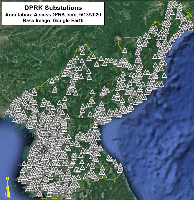
Those sources of energy, along with the new solar and wind locations, distribute their electricity through a network of at least 1,322 electrical substations.

The following set of images show the locations of the country's fossil fuel power plants, its hydroelectric plants, main wind and solar farms, and all of the substations.


The country continues to try to improve its energy production through all means available. A kilometer-long solar farm was constructed in Sinuiju in 2019 and the country is in the middle of finishing up construction of its largest hydroelectric project that's currently underway. The Samsu-Sinhung hydroelectric station (also called Tanchon) will rely on a 60 km tunnel to deliver water from the Samsu reservoir in Ryanggang Province to a generating station in Sinhung, S. Hamgyong Province.

Additionally, they have been taking steps to decrease the energy demand on the main grid by installing solar panels at most cell phone towers. With the country's 1,150 or so cell towers, this step alone contributes anywhere from 1 to 3 megawatt hours of power to the system during peak hours. (Cell tower energy production levels depends on several variables which aren't easily discoverable with North Korea.)

Powering North Korea relies on a complex network of generating sites, distribution points, and other infrastructure that is often many decades old. Inefficiencies within the system continue to pose a major obstacle to achieving energy sufficiency as upwards of 30% of electricity is lost through transmission and distribution by the time you get to rural areas, with a 2014 national loss average of 16% - five times the loss rate of South Korea.

Reviving the entire system would cost billions the country doesn't have. In the meantime, the regime seems to be dealing with this perennial problem by investing more in hydroelectricity to ensure energy levels are sufficient to meet core industrial and agricultural needs, and has been letting individual families fend for themselves by buying solar panels, solar water heaters, and installing micro-wind turbines on their homes and apartments. This approach will not solve the energy problem, but it does give the state some extra options until more systemic and economical solutions are discovered.


Patreon Special Access
Patreon supporters at the $20 tier are entitled to exclusive data sets. The Google Earth file for this post is one of those exclusive offers. The file contains every identified thermal power plant, hydroelectric dam, wind turbine, every major solar site, the country's network of electrical substations, and dozens of examples of small-scale solar installations. In all, it has over 1,800 places marked and with additional information where available. Please consider supporting the #AccessDPRK Project on Patreon and get access to this and other exclusive information.

I would like to thank my current Patreon supporters: Amanda O., Anders Omholt, GreatPoppo, Kbechs87, Planefag, Russ Johnson, and Travis Murdock.


--Jacob Bogle, 6/13/2020
AccessDPRK.com
www.JacobBogle.com
Facebook.com/JacobBogle
Twitter.com/JacobBogle

Thursday, June 4, 2020

Old School Fortifications Still Part of DPRK Military Plans

In this day of guided bombs, stealth fighters, and rail guns, North Korea is holding fast to World War II-style "practical" fortifications to keep their country from being quickly overrun in the event of an invasion.

After the Korean War, Kim Il Sung ordered that the country be made into an impregnable fortress. To that end, anti-tank walls, dragon's teeth, and concrete "fall barriers" (tank traps) were constructed all over the country, especially along the coast and DMZ to defend against invading forces.

The country's road system was also intentionally left in a poorly developed state to hamper the movement of heavy vehicles and tanks which would instead get stuck in the mud or squeezed into choke points to be picked off by North Korean forces.

Anti-tank "fall barrier" (German: fallsperre) located along the Pyongyang-Kaesong Highway in North Korea. Image source: Commons.

Some of these anti-tank fall barriers, which consist of concrete blocks stacked precariously on top of each other waiting to be toppled into the road to prevent tanks and other equipment from moving forward, are even placed at key points within the interior to protect mountain passes and other key transit sites.

While dragon's teeth and anti-tank ditches have largely been left to decay over the decades (with many sites being completely useless today), Kim Jong Un has continued to construct tank traps.

Another common fall barrier design. Image taken near the DMZ.


In 2017 with the publication of the #AccessDPRK Phase II Map, I had identified over 500 tank traps around the country - 198 were located near the Demilitarized Zone. Since then, I have located several others that I missed but I have also found a number of them that have been installed in just the last few years (while most others have been around for decades).

Map of all identified tank traps as of June 2020.

As the map shows, tank traps have been positioned along the DMZ and coastal regions to stall any invasion. Pyongyang is also protected by groups of them to the east and west (as the southern approaches are already protected by the DMZ).

Below are four new examples of these barriers that have been installed since 2015.

Near Kwaksan, a tank trap was added in 2015. It also includes a section of an anti-tank wall that runs for approx. 460 feet and blocks a small depression that tanks could have driven through to bypass the tank trap along the road.  Coords: 39°39'21.60"N 125° 0'3.08"E

Anti-tank wall and tank trap under construction on March 18, 2015.

The completed system as seen on April 1, 2017.


This one was built in Onchon in 2017 and reinforces another older road block 4 km away to prevent travel through the Cholhyon Pass of Mt. Sindok. Coords: 38°50'46.76"N 125°20'2.57"E

Four sets of blocks as seen on Feb. 27, 2019.


Two have been constructed near Myongchon. One in 2015 and the other in 2018. They block two points along AH 6 and is part of the main system of tank traps in North Hamgyong Province that defends the main transportation routes.

North trap (installed in 2015) - 41° 7'2.21"N 129°22'31.56"E


South trap (installed in 2018) - 41° 4'31.58"N 129°22'41.03"E


These are all similar to most other examples in the country and are meant to be able to block the width of regular country roads (which are predominantly unpaved). There are some examples of much larger road blocks, however.

This is a set of four blocks on the eastern approach to Pyongyang along the Pyongyang-Wonsan Highway. Since the road is wider than most, the blocks are taller; approx. 30 feet in height (compared to ~15 for most others).


I would like to thank my current Patreon supporters: Amanda O., GreatPoppo, Kbechs87, Planefag, Russ Johnson, and Travis Murdock.

--Jacob Bogle, 6/3/2020
AccessDPRK.com
JacobBogle.com
Facebook.com/accessdprk
Twitter.com/JacobBogle
Sunday, May 10, 2020

North Korea's Underground Navy: A Review


Many countries have underground facilities for their navies. Places to protect submarines, places to defend against surprise or nuclear attacks, underground storage, places that have all kinds of purposes.

One large example was the Soviet base in Balaklava, Crimea. China currently maintains at least six underground submarine bases. The United States has an enormous underground fuel storage site in Hawaii.

North Korea is no different.

North Korea has a tremendous amount of experience digging tunnels. I have found hundreds of tunnels across the country, hundreds of artillery sites that pop out of tunnels, scores of underground factories, and quite a few underground naval sites.

Bounded on two sides by the ocean and with 2,495 km of coastline, the Korean People's Navy has a strength of 60,000 men and over 800 vessels, making it one of the largest navies in the world in terms of vessel numbers. And while most of their naval technologies are decades behind the West, Kim Jong Un has been focusing on modernizing the fleet. Furthermore, what they lack in technology they can make up (some of that gap) by sheer numbers.

North Korea has 70-80 submarines, which places them on par with the United States (based on numbers) and far outpaces South Korea. Their navy has been able to inflict substantial damage in attacks like the Second Battle of Yeonpyeong in 2002.

And so, it makes sense to marry navy and tunnel together. Underground naval bases provide safety in the event of attack and secrecy to develop, arm, refuel, and launch attacks. Having multiple sites also makes it more difficult for an attacking country to quickly knock out North Korea's navy.

The country has 13 identified underground naval sites. Some can accommodate submarines but most currently serve various types of surface ships. Interestingly, North Korea's main submarine base for the Sea of Japan (East Sea), which is based on Mayang Island, lacks any apparent underground facilities.


(Click on images for larger view)

The facilities range from simple tunnels to more complex facilities that are accessed from the sea and cover a large footprint.

Starting with the Yellow Sea (West Sea) bases:

Taewha-do Underground Base: 39°25'59.69"N 124°37'2.39"E

Taewha-do is on an island (the -do suffix means island) and consists of a small underground facility and a turntable to enable vessels to be moved around the base on a short rail system. There is only a single dual entrance/exit point to the underground facility (UGF) but the island's size could theoretically accommodate an enormous UGF inside. However, it only appears to house small patrol boats and the island garrison is no larger than battalion sized.

Very little information about the base is publicly available and most of the information that does exist relates to a series of small military actions during the Korean War, before the UGF was construction. The island rises steeply out of the ocean and can provide up to 600 feet of solid rock on top of the UGF, giving it excellent protection.

Sok-do is not necessarily an underground base but rather it is a set of four hardened pens that allow craft to be protected. Located at 38°38'7.33"N 125° 0'26.27"E, it doesn't appear to be in use. It lies just 5 km from Pip'a-got, which is a primary naval base.


Pip'a-got is the largest naval base immediately outside of the West Sea Barrage, which cuts off direct access to the Taedong River and Pyongyang.

Pip'a-got naval base.

The base consists of a large protected harbor (created by a set of breakwaters), hundreds of buildings, and seven distinct ship handling sites (dry docks, main harbor, UGF, etc). It covers approx. 5 square kilometers.


The underground component consists of a 600-meter long tunnel that connects a turntable (that can take ships from a slip and bring them to the tunnel entrance) to an exit that enters directly into the sea, bypassing the large seawalls.

The tunnel could include other facilities like fueling, loading weapons, and repair, but the interior layout is not known. The hill it cuts beneath rises from ~90 feet at the turntable to a maximum height of ~250 feet along the path of the tunnel.

Sunwi-do & Sagot (Ryongho) Bases
Sunwi-do has a small base at the far northeast end of the island. It is across from the larger Sagot base on Ryongho Island 4 km to the north. Both bases are in South Hwanghae Province are the southernmost underground naval facilities on the west coast. The base at Sunwi-do lies a 31 km from the South Korean island of Yeongpyeong.

The base on Sunwi Island, 37°46'11.59"N 125°20'21.45"E

At its height, the island provides ~180 feet of rock over the Sunwi tunnel which runs for 250 meters.
North Korea has several classes of patrol boats and Sunwi seems to be a base for them. In the imagery provided by Google Earth, at no time has there been more than 13 ships and none over ~28 meters in length.

In this image of Ryongho, four classes of ship can be seen. Upwards of 36 ships have been seen at Ryongho but some may have actually been small fishing vessels along with the military craft.

Sagot base is split between two main facilities. One is at the town of Sagot, on the mainland 1.8 km to the north, and the second is the UGF on Ryongho Island (37°48'17.24"N 125°21'9.58"E).
A direct line from the Ryongho entrance to the exit runs 290 meters but the full tunnel path isn't a straight line. It is likely at least 365 meters in total length. Between 150 and 250 feet of rock sits above the site, depending on location.

The exit has apparently silted up and cannot be used as a direct exit point for sailing into the sea. Any vessel must be towed down the "hump" from the UGF exit point to the water. Why this hasn't been corrected would only be speculation, but it has been the case since at least 2004.

NK-01 antiship cruise missiles (a local variant of the Soviet P-15 Termit (aka Styx) are believed to be deployed at the base.

Along the northeast edge of the island is a series of small tunnels for terrestrial vehicles and other equipment. This is a common feature found at many bases across the country.

East Sea (Sea of Japan) Bases

Puam-dong is the first base on the east coast. (Going north to south, as I did for the Yellow Sea bases.) Located at 41°19'17.15"N 129°46'4.71"E it is a primary navy base and has a large harbor protected by ~470 meters of breakwaters.

The base has been called a submarine base (and some of its features support that conclusion) but no submarines are visible in the available imagery. Other vessels stationed at the base include the Sohung-class PTG (guided missile patrol boat). This has been a key base for them since at least the 1980s.


Puam-dong is divided into two sections because of a hill in the middle of the base. The main section has headquarter facilities, barracks, and other buildings. The second section (to the south) is for maintenance.

The tunnel runs for at least 425 meters and the hill provides ~270 feet of rock above. The base also has a small underground storage facility higher in the hills at 41°20'12.02"N 129°45'24.94"E.

Cha'ho is a major submarine base located at 40°12'18.28"N 128°38'59.31"E in S. Hamgyong province. Including the harbor, it covers approx. 7.7 square kilometers.


Development of Cha-ho began in 1961 and it was transformed from a small base for patrol craft to a major submarine facility. By 1968 the underground portion was under construction. Unlike many other bases, it has rail access.

Unlike land-based underground facilities, where large piles of debris can be seen and analyzed to yield the approximate volume of the UGF, sea-based sites tend to lack any visible debris (since it can just be dumped under water) making it almost impossible to determine its size or layout using traditional methods. (Technology does exist that can shed light on the internal nature of the site using special techniques, but those are beyond the reach of most.)

However, at least a portion of the quay positioned between the entrances of the UGF may be made up of excavated debris based on a review of declassified images.


Taking the curved shape into account, the tunnel runs at least 330 meters and is protected by upwards of 200 feet of rock. I suspect that the main tunnel is placed farther back than I have it drawn, but that's why things are labeled "approximate".

Throughout the base Sang-O class (mini subs) and Romeo-class submarines can be seen. Romeo's are Chinese built, Soviet originated submarines that North Korea first acquired in 1973.

Ryoho-ri (Toejo-dong) Base is the location of the East Sea Fleet Command. It goes by several designations, Ryoho-ri, Yŏho-ri (an alternate spelling), and Toejo-dong (the name of the bay and also commonly used). Its location is 39°52'33.92"N 127°46'43.45"E.


As if signifying the base's importance, one of North Korea's many leadership residences is adjacent to the base. Ryoho is also serviced by rail.

The base doesn't appear to have any shipbuilding capabilities, but it does have a small repair facility for patrol boats. As mentioned, it is the headquarters for the East Sea Fleet and commands all of the bases and associated facilities along the east coast. One of the subordinate units at the base is KPA Unit 158.

The underground facility follows the same basic design as all the others. Its tunnel is ~315 meters long and is covered by roughly 200 feet of rock.

Samil-ri is a small UGF that consists of a single entry point. Located at 39°22'18.03"N 127°26'18.43"E it is on a small peninsula that's part of the much larger Munchon Naval Base.

Across from it on the other side of the peninsula (over 900 meters away) is a turntable but it doesn't appear to have been used in years and the images available on Google Earth make it difficult to confidently assert that there's a tunnel connecting the two points.


It's hard to gauge how active this site is, particularly since the turntable doesn't appear to be in use, but the wider Munchon area has been the focus of a large modernization and expansion program which has been ongoing since 2014. The Munchon-Wonsan region is an important military and industrial area, and various improvement projects have occurred there including the Kalma International Airport, Wonsan-Kalma tourist zone, and the nearby Hodo missile test facility.

Of note, various materials can be seen at the entrance site in recent images that could be used in a restoration project.

Sindo & Yodo island bases

Sindo is a small, narrow island in Yonghung Bay, off of Wonsan. It has a small underground site but unlike Samil-ri it definitely doesn't have an exit point. It is located at 39°13'18.11"N 127°31'10.04"E and would have a maximum length of 85 meters (based on the particulars of the island). The island's garrison seems to be geared toward operating coastal defense artillery and is located nearly a kilometer to the east.

The Yodo island site is located 8.7 km east of the Sindo site. Like Sindo, it doesn't have a second entry/exit point, but it does have a turntable. This allows approx. 8 vessels to sit on the beach and then individually brought into the tunnel for servicing and then moved back out and onto the "holding yard".

If you look closely at the image, you can see a vessel halfway in (or out) of the tunnel entrance.

Yodo has a much larger garrison and even has a small grass runway that extends for 660 meters (although a dirt path cuts across it near the southern end). The naval tunnel may run for 180 meters into the hill to reach 140-150 feet of rock depth. Directly across is a hardened coastal artillery battery and those tend to have small tunnels connecting them to the outside. If we assume the tunnel comes close to the battery, then the tunnel may run as much as 200-230 meters.

Namae Navy Base

Located at 38°48'9.76"N 128° 8'18.58"E Namae is a large navy base with a breakwater that creates 38 hectares of protected harbor. The northern end of the base contains the underground facility. Namae has the facilities available to service all of North Korea's surface fleet and may be able to dock submarines.


The entrance is approx. 20 meters in width and could be covered by as much as 200 feet of rock. There does appear to have been an exit point built, but the tunneling work was either never finished or there was some other problem. An exit structure was built but is in a state of disrepair.

By 2013 a hole had appeared in the roof of the possible exit structure and by 2019 the roof had collapsed entirely. Had the entire facility been completed, the tunnel would have run 515 meters and would make it the second longest confirmed tunnel after Pip'a-got.

Possible exit structure with collapsed roof.

The last of North Korea's underground navy sites is at Changjon, 38°43'59.96"N 128°12'45.45"E.

It's the southernmost naval facility on the east coast and lies a mere 18 km from the military demarcation line.

Changjon is divided into two sections. The northern section contains a large active navy base, the southern section (~1.8 km away) has the underground facility but it appears to have been abandoned. No military vessels can be seen in Google Earth images (which go back to 2005), and there is a civilian dock with a floating restaurant just a kilometer away. It's part of the Kumgang tourism system.


At the same time, a small naval unit is still directly connected to it and the base did serve as a "frontline base for North Korean submarines" before being suspended as part of the creation of the aforementioned tourist zone. However, Kim Jong Un has recently expressed a desire to enlarge the base, so this portion of it may become active again in the future.


Additional reading:
Work on Major Hovercraft Base Advances, AccessDPRK, 1/17/2020


I would like to thank my current Patreon supporters: Amanda O., GreatPoppo, Kbechs87, Planefag, Russ Johnson, and Travis Murdock.

--Jacob Bogle, 5/9/2020
AccessDPRK.com
JacobBogle.com
Facebook.com/accessdprk
Twitter.com/JacobBogle