Showing posts with label tunnel. Show all posts

Monday, July 24, 2023

Kim Jong Un's Underground Pyongyang

Verifying the existence of underground facilities can be a difficult task, especially when their existence is a state secret. But rumors eventually come out and tantalizing hints of their presence can sometimes be found.

For North Korea, these rumors tell of secret subway lines beneath Pyongyang and underground highways connecting major palaces, maybe even reaching as far north as the border with China. I have written quite a lot about North Korea's underground infrastructure, but direct evidence and declassified sources still remain scarce. 

Overview of the Pyongyang Government District.

However, within the secured government district of Pyongyang are signs of multiple tunnels and underground structures. While it's impossible to know how they all connect to one another or even if they do, their locations and prevalence do hint at a fairly robust underground network that supports the infrastructure, transportation, and security needs of Pyongyang's most important district.

The easiest way to identify underground facilities is to either spot their entrances or actually catch them being constructed. For the secured government district, most of the buildings were constructed decades ago, placing their secrets out of reach for those without security clearances. But under Kim Jong Un, there have been some substantial changes to the district and that has given North Korea watchers an opportunity to see observe some of them.

There are two main sets of tunnels within the 138-hectare district that are visible to satellite. The first is a set of four tunnels near the Central Committee Office building (also known as Kim Jong Un's office) and the adjacent villa (Residence No. 15). The second is a set of four tunnels leading to underground parking garages beneath three buildings that were constructed in 2018-2019.  

There is also a possible tunnel, marked in light blue, but I can't fully verify that it is a tunnel. In some images, however, it appears that there may be a road tunnel that dives under a gate near Kim Kyong-hui Hall, just south of Changgwangsan House.

But the tunnels around Kim Jong Un's office and Residence No. 15 are quite clear.

April 10, 2020 image of the four tunnels around the Central Committee Building (Kim's office) and his district villa, Residence No. 15.

Apart from the tunnels by the villa and office, which I'll detail next, there is also a smaller tunnel in the maintenance complex. This complex handles building heating and cooling equipment, provides maintenance services, and may also play a role in electricity and water supply to the adjacent buildings. The tunnel (39.016557° 125.743544°) is 5-6 meters wide and runs toward the southwest. It's visible on all satellite imagery going back to 2000.

The tunnel may simply lead to a hardened bunker housing additional equipment or it could actually connect into the Office 39 complex (which includes the Kim Il Sung Revolutionary History Institute [39.016134° 125.741890°] and other Party buildings). Given its size and location, I do not think this tunnel plays any special security role. Rather, it's most likely just an access tunnel for providing building services.


April 1, 2023 image showing changes since 2020.

In 2022 a villa was rebuilt and enlarged, and in late 2022 a new hardened structure was built over the site of the tunnel nearest Kim's office building. 

The 'office tunnel' is large enough for vehicles and may lead to an underground garage or a larger underground complex. The hardened structure above it is approximately 60 by 30 meters in size and rises approximately 3 meters above the surrounding gardens.

Conjectured tunnel layout.

Due to the number of visible entrances, a concept of the tunnel layout can be formed with some confidence despite not having all the information. 

The covered walkway from Residence No. 15 was constructed in 2010. It resembles another such walkway that was built in 2017 in the armed forces district 5 km north at 39.062677° 125.740196°. 

The southern tunnel entrance was also constructed ca. 2010-11. Following the path drawn in the above image, the southern tunnel is about ~150 meters from the northern tunnel at the Central Committee Office Building (CCOB). 

The northern tunnel, however, was only constructed in 2018. This means that the southern tunnel likely went directly to the CCOB, where an alleged 60-car garage also exists beneath the assembly hall. 
This connection allows people from Residence No. 15 to travel on foot or by car directly and safely to the CCOB. Then, in 2018, a new tunnel was built from the CCOB that would link up with the southern tunnel.

This construction also included the building of an underground structure which was later (2022) replaced by the 60 x 30-meter hardened structure now seen in satellite images. Allegedly, a small, electrified rail car is also employed within the tunnels, but I haven't seen any supporting evidence of that.

To the north of the Central Committee Office Building, between 2018 and 2020 four currently unidentified buildings were constructed. These buildings include glass-covered entrances to underground parking garages that, most likely, would also double as bomb shelters in the event of an air attack.

Underground garage entrances under construction in June 2020.

The underground garage entrances after completion are covered by glass canopies.


There are also reports (including from Hwang Jang-yop) that the Pyongyang Metro has a secret line for government use that connects important government and military installations around the capital, and that it even reaches as far as Nampo and Sunchon (50 km away). While this has never been independently verified, the government district does lie within 2 km of four subway stations, with the closest being Pongwa Station at only 600 meters away from Kim's office.

As most of the district was constructed in the 1960s and 1970s (as was the metro), underground entrances to the metro system could be hidden beneath key administrative buildings, beyond the prying eye of today's satellite fleet. I have doubts about a sprawling network of transportation tunnels connecting far flung facilities, but a local network connecting underground command centers and emergency escape routes is quite plausible. 

Location of other known tunnels and underground facilities (UGF).

Whether underground sites exist in isolation or connect to larger tunnel networks beneath the government district and beyond, the sheer number of bomb shelters and other underground facilities alleged to exist makes the possibility of a successful "decapitation strike" by South Korea or the United States far more difficult and less likely to be effective, as such an attack relies on knowing where the target individuals are and killing them before they have time to escape to another location.

While I can't comment as to the quality of their construction, as a regime hyper-focused on survivability, North Korea probably has the greatest density of underground facilities and secret tunnels of any country on earth. 


I would like to thank my current Patreon supporters who help make all of this possible: Alex Kleinman, Amanda Oh, Donald Pierce, Dylan D, Joe Bishop-Henchman, Jonathan J, Joel Parish, John Pike, JuneBug, Kbechs87, Nate Odenkirk, Russ Johnson, and Squadfan.

--Jacob Bogle, July 24, 2023

Saturday, October 9, 2021

Tunnel Construction Near Reconnaissance Base

The Oryu-ri Reconnaissance Base is located in western Pyongyang on the slopes of Mt. Ryongak (Ryongaksan) at 39.018886° 125.631910°.

The administrative center of the base along with one of the large communication dishes (left) as seen via Google Earth on Nov. 8, 2019.

Very little is publicly known about the facility and even the James Martin Center for Nonproliferation Studies' own Nuclear Threat Initiative database gives only a vague description of its location and describes it as a missile base (admittedly, there are only a couple old sources available). However, the National Geospatial Intelligence Agency's GEOnet Server does verify that a place by Mt. Ryongak is called Oryu-ri (Oryu Village). 

The NGA's name database along with the NTI's general location description both fit the area and I am confident that NTI is describing what is not a missile base as such, but some kind of reconnaissance/signal intelligence base. Oryu-ri may play a role in missile defense, but it is not where missiles are launched.

Anyway, the base covers approximately 80 hectares and has existed since at least 1985 based on Landsat imagery. The facility consists of two very large communication dishes (with a diameter of 28-29 m) as well as two smaller ones. It has a clearly identifiable entrance gate and an administrative area, but what is more interesting to me is the fact that it has two large tunnels going into the mountain.

The crowded area around Mt. Ryongak

Despite its apparently clandestine activities, Oryu-ri isn't in a super remote area. The southern side of Ryongaksan, where the base lies, is also home to two camps of the Korean Children's Union, a Juche Academy, and the National Gifts Exhibition Hall (constructed in 2010-2011).

In 2019, just 350 meters from the main gate, a new set of apartments were constructed. An unidentified but suspected new national archives complex was also built nearby at the same time.

Adding to things is that on the northern side of the mountain are three military-related facilities and the Security University of North Korea. All of this means a lot of people moving around the vicinity of the base.

This brings me back to the underground sites.

Despite having external buildings, most of the real operations of the base appear to go on beneath the mountain. Outside, there's an assembly hall, some agriculture-related structures, and each of the main satellite dishes has its own control building, but I can't point to anything that might be where the signals intelligence are gathered, stored, interpreted, or anything. To me, this suggests that the main operations of the base are carried out underground.

Main tunnels of the Oryu-ri Reconnaissance Base. This older image from 2011 gives some of the clearest views of these tunnels unobscured by tree cover.

Lending weight to that theory is the size of the tunnels. The two tunnels are about 12 m wide and each one has some type of support structure above the entrance, likely part of the ventilation system, meaning that the underground portion of the base is not inconsequential. In 2018, the eastern tunnel (39.021580° 125.633111°) had a structure built over the actual entry face, obscuring its view and giving added environmental protection as people go in and out.

The two tunnels are placed 275 m apart and have been placed roughly 60 meters above sea level, with the rest of the mountain looming a further 130 meters above, giving an enormous potential space inside and plenty of rock cover in the event of an attack.

Large underground facilities such as this often have smaller exit points/maintenance entrances, and Oryu-ri does indeed have at least one identifiable access tunnel on the eastern flank of the mountain at 39.024930° 125.636075°. There is a second site with an old spoils pile, indicative of previous excavation work, but the tunnel entrance may be obscured by trees or hidden with a building.

Based solely on the positions of the two main tunnels and the access tunnel, I estimate that the interior space (if it only consists of one level), is 70,000 sq. m. However, it could be as large as 80,000 or as small as 31,000, depending on the actual internal configuration. This estimate is arrived at by considering the most concise and simple geometric designs that connect the three sites, along with the topography of the mountain itself. There is no evidence that it sprawls through the whole mountain.

Back to the access tunnel.

It is the location of the access tunnel that makes this next part all the more interesting in my mind.

Initial excavation work at both sites as seen on Oct. 4, 2016.

Beginning in 2016, initial excavation work began on a new tunnel ~330 meters north of the identified access tunnel and in the same area as the suspected second UFG access tunnel (39.027561° 125.634293°). At the same time, more excavation work could be seen just behind the Security University, 1.3 km away at 39.039439° 125.631268°.

Moving forward to 2020, a lot of progress had been made constructing the tunnel and a smaller construction access tunnel had also been added between the two main entry points of this new, larger tunnel, which is a common feature of long tunnels of every kind. 

This new, large tunnel is approximately 10 meters wide and has two probable courses. One is simply a (mostly) direct line from Point A to Point B which would take it almost right beneath the National Gift Exhibition Hall, and the other would have the tunnel more closely follow the internal bend of the mountain, allowing for maximum overhead coverage and without risking the structural integrity of any other buildings.

The white line shows the most probable direct path of the tunnel. The blue line shows a more inward curve within the mountain and has greater overhead rock coverage.

Because the new tunnel is located so close to the Oryu-ri base, with its location next to the base's UGF access tunnel, and that it comes out at a national security university, it raises these questions:

1. Does the new tunnel directly connect to Oryu-ri's underground facility? 
2. Could it be part of an expansion of the underground base?
3. Does it indicate joint activities between Oryu-ri and the Security University?
4. Or is it simply a future shortcut to the university from the new subway stations that are being built along the Hyoksin-Kwangbok subway line extension 2-3 km away from Oryu-ri?

This most recent Google Earth image shows clear tunneling work of a size capable of allowing vehicle traffic to pass through the tunnel.

Time will tell, particularly if the access road going from the Oryu-ri side of the new tunnel gets repaved and realigned to fit the other roads in the area, which would better connect it to future subway stations. Until then, we're left with yet another tunnel without an immediately clear purpose. 


I would like to thank my current Patreon supporters: Amanda O., GreatPoppo, Joel Parish, John Pike, Kbechs87, Rinmanah, and Russ Johnson.

--Jacob Bogle, 10/8/2021

Thursday, February 18, 2021

What Lies Beneath the Underground Republic

The internal workings of North Korea largely remain a secret to many in the world, and even Western intelligence agencies have bemoaned the relatively sparse amounts of information that flow out from the DPRK's borders. It's even suspected that the United States has no more than two or three low-level spies in the country - if there are any at all. This means that one of the main sources of information about this "hermit kingdom" comes from what can be gleaned through a vast array of satellites. 

One thing that becomes clear from these spies in the sky, is that North Korea has a fetish for digging.

During the Korean War, Kim Il Sung and his army witnessed the terrible and far-reaching ability of the Allied air forces to knock out military and economic targets from the sky. The northern part of the Korean Peninsula had been turned into Korea's industrial and most developed region by Japan during their 35 year occupation, but by the end of the three year Korean War, upwards of 85% of all buildings in North Korea had been completely or partially destroyed. The Korean War saw more tonnage of bombs dropped than in the whole of the Pacific Theater of WWII.

Kim Il Sung's expectation that Korean War II was imminent, and based on the lessons he learned during the first war, led to him commanding that the whole country be fortified, saying in 1963, "we must dig ourselves into the ground to protect ourselves"

The practical results of this are the countless miles of trenches along nearly every hill, a coastline ringed with artillery positions and anti-invasion obstacles, the second largest combined military and paramilitary force in the world, and lots and lots of tunnels, bunkers, underground factories, and other sites constructed beneath the surface and out of view. 


At this point, I want to sound a note of caution to those who like to let stories of North Korean mysteries run away with them. There has been plenty of speculation about the true extent of North Korea's underground infrastructure, with some going so far as to claim that most of their military bases are actually buried beneath the ground. The truth is, while both small and vast underground sites exist across the country, commercial satellite images do not support the idea that there's basically a parallel country underground. 

Military sites are easy to find if one knows what to look for and reviewing current and historic satellite images only reveal underground sites at some of them, and most of those are relatively small.  The only way you could claim that most bases have an underground facility (UGF) is if you include small storage bunkers or gun emplacements that are situated a few meters into a hillside. But I don't accept the definition of an "underground facility" as merely being "any usable structure with an inch of dirt on top". For the purposes of this article, UGFs are a sizable structure built into the ground, where the rock cover would provide meaningful protection from bombs and missiles.

Aside from military sites, major factories with UGFs are likewise easy to spot. I have looked at every square meter of the country more than once, and the 2021 AccessDPRK Pro Map is swollen with over 13,000 distinct military-related sites plus dozens of factories with an underground component. However, to reiterate, I haven't seen anything in commercial satellite imagery that convinces me there is a nationwide system of connected tunnels and underground sites.


Based on the AccessDPRK 2021 Map, Pro Version, the country has over 1,500 identifiable tunnels and underground facilities.

The sheer number of these sites overall is a little mind-boggling when you consider how relatively small North Korea is. The above map shows each of the 1,500+ tunnels and important underground facilities that I have managed to locate, as well as coastal batteries that have a clear underground component. It doesn't show the 850 hardened artillery sites, 492 drive-thru bunkers, or other installations that only have small access tunnels. The total number of large and small UGFs (which includes artillery sites and small storage areas) is estimated to reach as high as 14,000. 

Some sites were clearly constructed decades ago and were either abandoned or serve as emergency facilities in the event of open warfare. Because of this, their entrances have become overgrown with vegetation and that can make identification difficult. Furthermore, others have indeed been abandoned and mining operations or other domestic activities have encroached on the site; I saw little need to map those. 

There are also scores of stories about secret underground escape routes that connect Pyongyang and major palaces with underground rail lines that would allow the Kim family and top officials to be spirited away to the far north of the country, and even to China.

According to a 2015 report, the US military has mapped 6,000 to 8,000 of these "VIP" underground sites that North Korea's leadership could use to either hide or escape the country. The vast majority of them, however, would be simple bomb shelters (something that is common in South Korea, too). And, while this report lends credence to the idea of large, interconnected networks of underground facilities, the problem is that there is almost no direct visible evidence in the public sphere for such a massive system (although smaller tunnel segments have been identified). Additionally, this system is for the country's top leadership and isn't part of the normal domestic and military infrastructure of the country. So, this article is only going to focus on other underground infrastructure that plays a more "daily role" in the country.


While the exact purpose of each and every one of the sites is impossible to ascertain by simply looking at them from the air, most tend to fall into a handful of categories. There are a few major underground facilities, such as the Punggye-ri Nuclear Site, the Panghyon underground aircraft factory, and Kim's hardened helicopter base (which is part of a much larger underground command and control base). Most of the others can be classified into these: the underground factory or laboratory, the unspecified underground facility (many with protective berms at tunnel entrances), underground facilities at Navy and Air Force bases (excluding HARTS and storage bunkers), and basic tunnels (either individual tunnels or usually in groups of three).

The following set of images shows examples of various types of underground facilities. The satellite images used cover a large range of dates, but they were chosen because they best showed the sites in question.

Click on any image for an enlarged view.

The Hagap Facility in Chagang Province (40.081644° 126.189346°) is an example of a major underground site. Its exact purpose is unknown, but the two main theories are that it's either part of North Korea's nuclear program or a secured storage site for important government archives. Construction of the site has been ongoing for decades, punctuated by periods of inactivity, but since 2016, work has been steady.


Ryoho-ri Underground Naval Base (39.876051° 127.785328°)

This is a submarine base and the headquarters for the East Sea Fleet. It is one of 13 naval bases that have an underground or hardened facility. Ryoho-ri has two underground entrance points and suggests the existence of a large underground facility at least 300 meters in length and that could likely extend a further 150 meters into the hill. 

Ryoho-ri is so important that Kim Jong Il had a villa built nearby and both the villa and base have special rail access.


Pukchang Airbase (39.512137° 125.958563°)
Pukchang is one of 22 airbases and heliports that have associated underground facilities. I've already written about two of these in detail, the Sanghung-dong VIP Heliport in Pyongyang and the Kangda-ri Airbase near Wonsan. 

Pukchang is home to a Mig-23 fighter wing and has three main underground entrances into Obong Hill. It is also adjacent to the Yonggang-ni Helibase which has its own small UGF. 

Such facilities are used to store important aircraft and equipment, conduct maintenance, and at some airbases, even engage in manufacturing parts.


Tonghungsan Machine Plant (39.953611° 127.546918°)

Located in Hamhung, this is a major underground factory and is associated with North Korea's arms industry. Beginning in 2016, major reconstruction work began on both the underground portion and the external buildings. This reconstruction kicked off a series of new building and renovation projects at multiple arms facilities around the city including the Chemical Materials Institute and at the Hungnam Fertilizer Plant which produces chemicals used in various programs. 

Depending on Tonghungsan's exact size and layout, parts of the factory could be protected by over 150 meters of rock.


Taedonggang UGF near Pyongyang (39.174538° 125.946416°)
This is underground facility has a publicly unverified purpose. Located 6.5 km across from the Kangdong Residence on the other side of the Taedong River, it consists of four entrances divided into two sections. Tunnels 1 and 2 appear to be more for underground storage, while the size and configuration of the road and tunnels 3 and 4 suggest that they're for larger equipment (possibly TELs and MRLs).

Based on rough calculations of the volume of the spoil piles, there is at least 40,000 cubic meters of interior space for tunnels 3 and 4. That's the equivalent of a room 63x63 meters in size with 10-meter-high ceilings. The existence of a gantry crane and dedicated electrical substation can also clue us in to what purposes the site may be used for.


Pyongyang Armed Forces District UGF (39.059308° 125.733921°)
One of the largest identified underground facilities is beneath a hill in the middle of Pyongyang. One of the oldest entrance points is located at 39.059308° 125.733921° and is next to a secured villa. The tunnel can take VIPs into the facility that occupies a large portion of the hill or across the hill to the Sanghung-dong Heliport, where six helicopter hangars are protected by steel blast doors and hardened walls. 

Roughly 660 meters northeast from the original entry point is the newest entrance. It was added in 2017 and can take important people from an assembly hall directly into the UGF. 

This Armed Forces District UGF is one of multiple hardened command and control facilities within the city. 


While North Korea's engineers are capable of constructing large underground factories, they're still limited by the technology, education, and other factors that they have access to. North Korea is well known for their "speed campaigns" and for constructing large projects rapidly. Lack of enough materials due to sanctions and additional factors means that some of these projects end up shoddily built, with problems arising often and even occasional building collapses. These failures can also extend to military sites.

The following site is a coastal artillery position in North Hamgyong Province (41.896007° 129.950076°) that suffered a collapse, largely destroying the site.

Area before the collapse.


Area after the collapse.


North Korea built one of the deepest subway systems in the world, and they have a history of building underground facilities not only within their own borders but also around the globe. 

These places aren't just for hiding weapons or keeping the Kim family safe. Four massive tunnels that traversed the DMZ into South Korea are known about and some estimate that fifteen to twenty others could exist. Such infiltration tunnels could enable an invasion into South Korea with tens of thousands of soldiers and vast sums of equipment without warning.

From infiltration tunnels to escape routes 100 meters underground to new UGFs at ballistic missile bases, the difficulties in discovering this underground infrastructure and combating its ability to hide people and weapons present a continuing obstacle to intelligence. It may also provide a potentially unacceptable level of uncertainty regarding any offensive strike against the country by the United States or South Korea, as they may not know where each target person is exactly or if every nuclear bomb or technological site was hit. 


I would like to thank my current Patreon supporters: Amanda O., Anders O., GreatPoppo, Joel Parish, John Pike, Kbechs87, Planefag, and Russ Johnson.

--Jacob Bogle, 2/17/2021

Sunday, July 12, 2020

Mystery at Pyongyang Security Ministry

In 2020 the People's Security Department (aka Ministry of People's Security) was renamed the Ministry of Social Security. The MSS oversees a number of functions including police, prisons, assists in securing the distribution of food, and aides other security agencies.

It is one of the three "pillars" of DPRK state security. The other two are the military and the Ministry of State Security.

One of their facilities, according to the 38 North Digital Atlas, is this complex on the western outskirts of Pyongyang. Its coordinates are 39° 3'10.50"N 125°40'14.21"E. Landsat/Copernicus imagery suggests this facility was built ca. 1989-1992 but the satellite resolution is low enough as to make a fully certain date range difficult.

In recent years, an underground complex has been constructed. Underground facilities (UGF) are not rare in North Korea, but this one consists of a "cut and cover" tunnel - not one that is excavated into a hill but where a trench is dug, the tunnel structure built, and then the site is covered over to hide it. Identifiable examples of cut and cover tunnels are indeed rare in the country.

The exact purpose of this tunnel/underground facility is a bit of a mystery, but considering its location, I feel that detailing its ongoing construction history is important.

General outline of the complex.

The two sections of the complex are joined by a tunnel that runs beneath the central hill dividing the site. The tunnel is approximately 188 meters in length.

The tunnel allows vehicles quick access to each side of the complex without having to go around the hill. The facility has undergone many changes over the years, but this tunnel has existed since at least 2000.

At the very rear of the complex is another underground site. Whether or not it is directly connected to the Ministry complex isn't known but its proximity is interesting.


A trench has existed at the left-side facility since at least the year 2000 and implies that plans for this new underground structure have been around for a long time.

The trench excavation runs about 205 meters long and averages 12 meters wide.

Little else changed at the site until 2013 when several temporary buildings were constructed near the trench, and minor work at the upper end of the trench can also be seen. (Clearer images of this work come from 2014.)

Image showing construction activity in November 2013.

By September 2014, the upper portion of the tunnel is taking shape and a new building had been constructed at the site they were leveling off in 2013.

In 2014 other changes become visible including the addition of multiple permanent buildings (some were still under construction at this time).


By this time, it's clear that a tunnel had been excavated, the sides of the trench had been shored up, and the debris pile shows activity. It isn't known if this tunnel goes into the central hill or connects to the road tunnel between the two sections, but if you draw a straight line following the new walls of the trench, it does intersect with the existing road tunnel.


This at least theoretically gives the possibility that the entire central hill is actually a large underground facility that now has three points of access: the original road tunnel, the new tunnel under construction, and the older rear UGF. This part is merely speculation but the possibility of a large hidden facility is very interesting, as we know that numerous underground facilities exist in North Korea including some that are used in training security forces to hide their clandestine activities.


By April 2017, a concrete structure (or "box") can be seen inside the trench. At this stage, it is approximately 40 meters long and 5-6 meters wide. Additional work around the area to prepare for more construction has also taken place.

On the image dated October 26, 2017, it becomes clear that the concrete section from April was just one small part of a larger concrete tunnel structure that is now 155 meters long and about 10 meters wide.


This type of structure is similar to long military "drive thru" bunkers that exist throughout the country (at least 400 exist at last count). One such example is this bunker, also in Pyongyang, that is similarly divided into two segments and is 10-12 meters wide. It is approximately 190 meters long. These structures are typically used to house and protect various vehicles.


However, these other drive thru bunkers are usually seen as part of military bases and never as part of building construction, making this Ministry structure unique as far as I am aware.

By April 2018, the tunnel had been covered and the area leveled off. The foundation of a new building had also been dug at the north end of the site.


Fast forward to the end of 2019 and the new building has been completed and an entrance site to the tunnel was nearing completion (final touches, landscaping, etc.) By November, another foundation can be seen. The new foundation is in the middle of the construction site and sits on top of the tunnel.

Based on the most recent Google Earth image, there is vehicle traffic going in and out of the tunnel. The square foundation has also had some additional work.


On the above March 13, 2020 image, you can see a driveway leading into the new foundation. The angle doesn't allow for this to be a second entrance into the main tunnel. The whole area has been raised above the tunnel, however, allowing for a low/shallow basement to exist at the new building site. This most likely where the driveway is going.

More recent satellite imagery (that I am not free to share publicly) shows that construction at the site is slow but ongoing. Unfortunately, it doesn't provide further clues to the site's purpose.

Lastly...

While not associated with this site at the Security Ministry, there is another underground construction that likewise began in 2017 and consists of a main tunnel structure. Its coordinates are 39°11'38.26"N 125°45'14.04"E, or 1.8 km north of the Kim Jong Il People's Security University in northern Pyongyang. The tunnel entrance is 12-13 meters wide and it has no apparent exit point.


I would like to thank my current Patreon supporters: Amanda O., Anders O., GreatPoppo, Kbechs87, Planefag, Russ Johnson, and Travis Murdock.

--Jacob Bogle 7/11/2020
AccessDPRK.com
JacobBogle.com
Facebook.com/accessdprk
Twitter.com/JacobBogle

Friday, July 3, 2020

Largest Hydroelectric Project in DPRK Heads Toward Completion

North Korea is no stranger to mega projects. The May Day Stadium (largest seating capacity in the world), Ryugyong Hotel (the abandoned "hotel of doom" that would have been the tallest in the world back in 1992), and the West Sea Barrage (an 8-km long dam across the mouth of the Taedong River) all bear witness to North Korea's willingness to expend enormous resources on enormous projects, even if they don't always work out as planned.

One such current mega project is the Tanchon Hydroelectric Power Station.


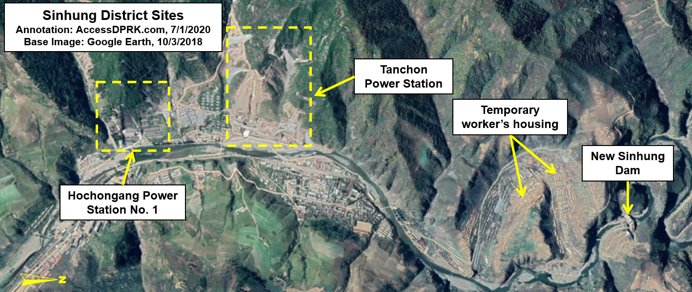
Despite being named for the coastal city of Tanchon, the project centers around the border area between Ryanggang and South Hamgyong provinces, specifically around the worker's district of Sinhung, 53 km away from Tanchon as the crow flies. However, this isn't a run-of-the-mill hydroelectric dam. It is a massive complex that starts at a new water intake point at the Samsu Reservoir (near Hyesan) and then carries water through a roughly 60 km-long tunnel to the electricity generating stations in Sinhung. The tunnel is the longest such tunnel in the country and makes this the largest hydroelectric project currently underway by North Korea.

The next longest water tunnel for hydroelectricity that I am aware of is the Songwon Dam tunnel. Constructed in 1987, it runs a mere 42 km.


The Tanchon project is actually part of a larger attempt to take advantage of the rivers and steep valleys of this region. The northerly-flowing Hochon River is the primary source of water. The northern extreme is the Samsu Dam and reservoir, which lie less than 10 km from Hyesan and the Yalu River border with China (into which the Hochon empties).

In this complicated image you can see the path of the Hochon River (blue), flowing south to north. That water fills the Samsu Reservoir where the water intake site is located for the Tanchon project. That water is then diverted through a tunnel (white) where it travels north to south (against the natural gradient of the area). It will then enter the dual Tanchon generating stations in the small town of Sinhung. From there, it empties into the Namdeachon River (yellow) which flows north to south and empties into the sea at the city of Tanchon.

Moving south (aka upriver), lies the Sachophonyg Reservoir which feeds the Hochongang Power Station in Sinhung (11.8 km away and is adjacent to the new Tanchon generating stations). Both the Hochongang Power Station and the new Tanchon stations empties the waters of the Hochon River into the Namdaechon River, across a sort of continental divide thanks to the tunnels, as the Namdaechon then runs south and empties into the Sea of Japan, whereas the headwaters of the Hochon arise in the Hamgyong Mountains (also known as Gangbaekjeonggan) which create a natural border between Ryanggang and South Hamgyong provinces.


Being built at the same time as Tanchon is a smaller hydroelectric dam on the Hochon at Saphyong-ri (pictured above) and a hydroelectric dam at Sinhung (also called Power Station No. 5) on the Namdaechon River that is less than 2 km from the new Tanchon generating station.

Exploiting this riverine resource goes back nearly a century. During the Japanese occupation era, Yutaka Kubota (founder of the Japanese engineering firm Nippon Koei) was a consultant for the Hochongang River Overall Project from 1925-45, and the project was expected to eventually generate 338 MW of electricity.

Samsu Dam ca. 2011. The large propaganda sign in the background reads "Long live Songun Korea's General Kim Jong Un!" and is over half a kilometer long. Image source: Wikimapia.

In terms of North Korean efforts, the Samsu Hydroelectric Dam alone was supposed to produce 50 MW of electricity to provide for Ryanggang Province and the important Hyesan Youth Copper Mine. Built from 2004-2007, the dam was beset with problems and still fails to live up to expectations.

Kim Il Sung introduced the modern idea of exploiting the rivers in the area in the years soon before his death and wanted the project to generate 400-500 MW. But it wasn't until 2016 when Kim Jong Un announced the construction of the Tanchon Power Station that work finally began. According to a May 2017 Pyongyang Times report, the project is supposed to generate "several hundred thousand of kilowatts" and would indeed be the largest hydroelectric project in the country's history.

During Kim Jong Un's 2016 New Years' address he said, "The problem of electricity should be resolved as an undertaking involving the whole Party and the whole state." Giving little detail about the project he went on to say, "The construction of the Tanchon Power Station and other projects for boosting the country’s power-generating capacity should be promoted along with the efforts to ease the strain on electricity supply by making proactive use of natural energy." 

Such an undertaking would indeed require the effort of the "whole state".

As discussed in the Songwon article, one reason to not locate the electric generating station at the site of a dam or to excavate miles of tunnels to divert water elsewhere, is to take advantage of a substantial change in elevation. The greater the difference between the elevation of where the water is stored (in this case the Samsu Reservoir) and where it runs through the turbines at the generating station, the greater the power generated.


The approximate elevation of the water intake site at Samsu is 2,500 ft above sea level. The tunnel cuts through mountains and valleys on a downhill gradient to deliver the water to a point roughly 1,800 feet above sea level. This represents a 700-foot drop, something no existing traditional hydroelectric dam in the country could provide. For some perspective, to otherwise maintain a hydraulic head of 700 feet would require a traditional dam on the scale of the Glen Canyon Dam in the United States.

The elevation drop also allows a relatively small amount of water to pick up momentum and hit the generating turbines with more energy, producing more electricity. Both the Songwon and Samsu water intake sites are placed at shallow ends of their respective reservoirs, meaning limited amounts of water can transit the tunnel system. This may seem counter intuitive, to only have a little water flowing through, but considering the number of droughts North Korea has, it could also allow for a more constant supply of electricity (albeit limited) but without draining the reservoirs or damaging the tunnels over time.


Despite all the work visible via satellite images, by March 2020 the project was only fifty-percent completed. On April 17 the regime announced that the number of "national projects" would be cut from 15 to 5 projects. One such project is the new Pyongyang General Hospital and it is consuming substantial resources from across the country.

However, according to the Pyongyang Times, by June construction was being "pushed dramatically" and key parts of the project are now nearing their "final stage". This jump in activity is a common theme among North Korean projects and suggests that Tanchon is one of those five main national projects still being given priority as their economy struggles due to COVID-19 measures and ongoing sanctions.

Once completed, Tanchon would be the culmination of generations of planning and levels of backbreaking work rarely seen in today's modern world.


The 60-kilometer tunnel was built by cutting dozens (over 50) of individual access tunnels into solid rock to slowly expand and lengthen the main water tunnel. North Korea lacks tunnel boring machines, so the work is being done with small excavation equipment and by hand.
The construction of the generating station will consume thousands of tons of concrete and steel, and its power distribution lines will run for untold miles connecting the site to the national energy grid.

Unfortunately, any projections that Tanchon will substantively ease regional energy needs should be taken with a grain of salt. As mentioned, Samsu Dam has failed to generate electricity at its designed capacity and other dams have likewise suffered from setbacks. Even the backbone of North Korea's energy grid like the Pyongyang and Pukchang thermal power plants are constantly plagued by generation and efficiency problems, and blackouts in Pyongyang itself are still a common occurrence.

However, if Tanchon does live up to the majority of expectations, it and the other hydroelectric stations along Hochon's 220 kilometers will finally surpass the planned generating capacity by the Japanese all those many years ago.


Additional reading:
38 North has been covering the construction progress of the Tanchon project. You can read their detailed work here and here. Also, see AccessDPRK's November 2020 update.


I would like to thank my current Patreon supporters: Amanda O., Anders O., GreatPoppo, Kbechs87, Planefag, Russ Johnson, and Travis Murdock.

--Jacob Bogle, 7/2/2020
AccessDPRK.com
JacobBogle.com
Facebook.com/accessdprk
Twitter.com/JacobBogle