Showing posts with label road blocks. Show all posts

Thursday, June 4, 2020

Old School Fortifications Still Part of DPRK Military Plans

In this day of guided bombs, stealth fighters, and rail guns, North Korea is holding fast to World War II-style "practical" fortifications to keep their country from being quickly overrun in the event of an invasion.

After the Korean War, Kim Il Sung ordered that the country be made into an impregnable fortress. To that end, anti-tank walls, dragon's teeth, and concrete "fall barriers" (tank traps) were constructed all over the country, especially along the coast and DMZ to defend against invading forces.

The country's road system was also intentionally left in a poorly developed state to hamper the movement of heavy vehicles and tanks which would instead get stuck in the mud or squeezed into choke points to be picked off by North Korean forces.

Anti-tank "fall barrier" (German: fallsperre) located along the Pyongyang-Kaesong Highway in North Korea. Image source: Commons.

Some of these anti-tank fall barriers, which consist of concrete blocks stacked precariously on top of each other waiting to be toppled into the road to prevent tanks and other equipment from moving forward, are even placed at key points within the interior to protect mountain passes and other key transit sites.

While dragon's teeth and anti-tank ditches have largely been left to decay over the decades (with many sites being completely useless today), Kim Jong Un has continued to construct tank traps.

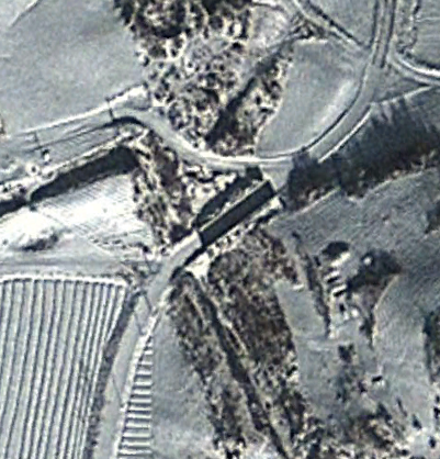
Another common fall barrier design. Image taken near the DMZ.


In 2017 with the publication of the #AccessDPRK Phase II Map, I had identified over 500 tank traps around the country - 198 were located near the Demilitarized Zone. Since then, I have located several others that I missed but I have also found a number of them that have been installed in just the last few years (while most others have been around for decades).

Map of all identified tank traps as of June 2020.

As the map shows, tank traps have been positioned along the DMZ and coastal regions to stall any invasion. Pyongyang is also protected by groups of them to the east and west (as the southern approaches are already protected by the DMZ).

Below are four new examples of these barriers that have been installed since 2015.

Near Kwaksan, a tank trap was added in 2015. It also includes a section of an anti-tank wall that runs for approx. 460 feet and blocks a small depression that tanks could have driven through to bypass the tank trap along the road.  Coords: 39°39'21.60"N 125° 0'3.08"E

Anti-tank wall and tank trap under construction on March 18, 2015.

The completed system as seen on April 1, 2017.


This one was built in Onchon in 2017 and reinforces another older road block 4 km away to prevent travel through the Cholhyon Pass of Mt. Sindok. Coords: 38°50'46.76"N 125°20'2.57"E

Four sets of blocks as seen on Feb. 27, 2019.


Two have been constructed near Myongchon. One in 2015 and the other in 2018. They block two points along AH 6 and is part of the main system of tank traps in North Hamgyong Province that defends the main transportation routes.

North trap (installed in 2015) - 41° 7'2.21"N 129°22'31.56"E


South trap (installed in 2018) - 41° 4'31.58"N 129°22'41.03"E


These are all similar to most other examples in the country and are meant to be able to block the width of regular country roads (which are predominantly unpaved). There are some examples of much larger road blocks, however.

This is a set of four blocks on the eastern approach to Pyongyang along the Pyongyang-Wonsan Highway. Since the road is wider than most, the blocks are taller; approx. 30 feet in height (compared to ~15 for most others).


I would like to thank my current Patreon supporters: Amanda O., GreatPoppo, Kbechs87, Planefag, Russ Johnson, and Travis Murdock.

--Jacob Bogle, 6/3/2020
AccessDPRK.com
JacobBogle.com
Facebook.com/accessdprk
Twitter.com/JacobBogle

Saturday, April 27, 2013

Coastal Defenses

North Korea's coasts are littered with defensive positions, a hodgepodge collection of modern defenses mixed with those remaining from the Korean War.

Their design takes a layered approach and is dependent on the topography of the area. Naturally, locations closer to the DMZ and those along the eastern coast (facing the historical enemy of all Korea, Japan) are more built up. To the southwest, the land border between North and South Korea gives way to a series of river mouths and tidal inlets, most notably at the confluence of the Imjin and Han rivers. This area opens up to the sea and is where I consider the North Korean coast in this region to being.

Within 3 miles of the Northern Limit Line (the de facto maritime border between the two countries, although it is disputed) are a series of observation posts located along the river banks, fences to the rear of the posts, a number of sand berms which divide up the patty fields, successive layers of road blocks/tank traps, and mixed throughout are anti-aircraft artillery sites (AAA), gun lines, trenches dug into the hills, and hardened artillery sites (HARTS). There are also ammunition caches and other storage facilities dispersed throughout.

Here is a sample region.

(click images for larger view)

The Northern Limit Line runs in the middle of the river, naturally South Korea is to the south. The wider yellow line is the area I have marked as encompassing most of the border defenses which include the DMZ. It is approximately 3 miles (with some variation) from the NLL and the Military Demarcation Line which serves as the land border. The "P" icons are small position, observation posts etc. The red circles are HARTS positions, the "S" icons are storage facilities, "F" is for fortifications, the pink icon denotes bunkers or tunnels and the "policemen" mark road blocks of the type I discussed in this post

Here is an example of the sand berm and fence which runs the length of this region (as well as nearly all low-lying coastal areas).


To the north of this beach, in an area about 5 miles wide, there are 8 road blocks.


Now, moving away from the NLL here is a map of some of the small coastal positions located along the coast of South Hwanghae province. 


The island to the bottom right, labeled Keunyeonpyeong-do (also known as Yeonpyeongdo), is the South Korean island which was bombed by the North in 2010 which killed 4 and wounded 18 others. 

This is a close up of one of the larger positions. 


Literally thousands of miles worth of trenches can be found throughout the county. Some are left over from the Korean War and have no real use, but others are part of their active defenses. Like these:


Both east and west coasts are intermittently lined with obstacle courses aimed at preventing any rapid movement inland during an invasion. These "dragon's teeth" consist of row after row of concrete blocks which have been sunk into the sand. The rows, usually 10 running parallel to each other, make up a full "band" around 100 feet wide. Most of these were put in place decades ago, some have been removed and others still have simply been covered up with drifting sand and mud. Still, in some areas they would slow an advancing force. They tend to be found in low-lying areas which lack mountainous terrain within a few miles of the coast and they are often paired with road blocks and berms further inland as well as rows of berms along the beach itself.

In this example the obstacle band has been marked in red, you can see the multiple sand berms in nice little rows.


And a close-up of the dragon's teeth themselves:


Next is the defensive positions around a few coastal towns. If you look at the coastal defense map I gave you above, this area is roughly the 4 blue places marks in a cluster, to the north of Yeonpyeongdo Island. 


The blue lines are fences and the three red lines are the tank traps. As before, the red circles are HARTS, the blue marks are small positions, "G" is a gun line and "B" is a coastal battery.

Finally, these are just three additional images of some interesting coastal places:

An AAA site with trenches - 


A close-up of a hardened artillery site - 


And a reserve fleet of 10 ships. There are a number of these types of locations dotted around the coast. Some are just sitting in dry docks like these and others are actually housed in underground naval yards.


--Jacob Bogle, 4/27/2013

Tuesday, February 26, 2013

Road Blocks and Restricted Travel

In the United States and much of the free world, you can travel from town to town visiting friends and family. You can also travel from state to state without ever needing to worry about having travel documents or being questioned by the government. Things aren't so simple in North Korea.

The government controls every aspect of life and freedom of movement simply doesn't exist, except for the ruling family alone. If you want to go to a different city to visit family - you need travel papers. If you want to stay the night - you'll need additional approval. The country is filled with checkpoints and road blocks, especially as you make your way toward important cities, factories, and even the beach.

Road blocks typically consist of a series of large concrete blocks perched on top of a ledge so that they can be felled within moments and prevent an invading army from advancing...or to keep the people boxed in. Most of these road blocks are along the DMZ with South Korea (who has their own version of them) and so that can be understandable. After all, the two countries are still technically at war. Unfortunately for the citizens of the north these road blocks aren't confined to the border. There are also a number of them throughout the country, guarding mountain passes, on roads leading to the coast and at times in random places with no discernible justification.

Then you have the myriad of checkpoints. These are little more than a gate with a small guardhouse. Although they may not provide any resistance to an army on the move they do help to enforce the people controls that mark much of like in the DPRK. You can find them scattered everywhere but especially near factories, other important sites and the beach (to keep people from simply fleeing).


This image is of one such road block near the southern border. As you can see, these are very large blocks that would easily block a road for quite some time.

The image below is a sample region immediately adjacent to the DMZ on the North Korean side. Each icon represents a road block. There are hundreds of them over the course of the full 160 mile long DMZ.


Here are some examples of road blocks as seen from satellite imagery:


You can see a series of small squares on either side of the road. The line moving vertically is a double fence. This road block is accompanied by a guardhouse and military unit with a series of trenches cut into a small hill on the upper left. 


And in this image taken during winter you can clearly see the shadow cast by the road block. 

Below is an example of a gatehouse which guards an expansive area containing coal mines and other industrial buildings. You can see two small trucks lined up to leave the area.


Finally, we have a road block on a beach. This is part of an extensive network of gates and fences which will be the subject of my next post. People must check in and out in order to simply go out and fish (notice the small fishing boats on the tidal mud flats).


--Jacob Bogle, 2/26/2013