Although Iran hasn't demonstrated a working nuclear device, the country was believed to have had one of the most protected nuclear programs in the world with its range of air defense sites and numerous underground facilities. But following the June 2025 Israeli attacks on Iranian conventional military and nuclear infrastructure, backed up by the United States dropping fourteen "bunker buster" bombs on two key underground facilities, Iran's nuclear program has likely been knocked back by several years.

North Korea, too, has an extensive network of underground sites to support what is the most well-developed nuclear program of the world's traditional "pariah" states. In fact, it may have more underground facilities than any modern country except (perhaps) China. And unlike Iran, North Korea has proven that it has developed nuclear devices. So, finding ways to limit or even remove Pyongyang's nuclear capabilities is something Western governments have considered for years.
In light of the unprecedented use of the GBU-57 Massive Ordinance Penetrator (MOP) "bunker busters" against Iran's Fordow and Natanz nuclear sites, could they be used against North Korea's nuclear facilities?
A quick primer on these bombs and their capabilities. The GBU-57 MOP was the result of a US Air Force development program from 2002 to create very large conventional explosives. First tested in 2007, the first deliveries of the finalized MOP took place in 2011.
These bombs weigh 12,304 kg (27,125 lbs) and are designed to be dropped from the B-2 Spirit 'stealth bomber' - the only aircraft in the world capable of carrying the bombs. Through the use of precision guidance systems and a "smart fuse", the bombs can be dropped on a target and detonate at a pre-determined depth.
The exact penetrative capability of the MOP is classified but it is generally believed to be capable of penetrating 60 m (200 ft) of "ground" (what that means exactly is unspecified) and 18 m (60 ft) of reenforced concrete. However, the density of the overburden rock (limestone vs basalt) and the compressive strength of the concrete used at a target facility could dramatically impact the bomb's performance and damage.
In the case of the Iranian nuclear facilities that were bombed, parts of Fordow are estimated to lie more than 80 meters below ground, however, the bombs targeted ventilation shafts that led from the surface and may have given the bombs an easier path through the mountain into the underground facility.
So how prepared are North Korea's underground facilities to weather such an attack?
North Korea has thousands of underground sites but only a few dozen are associated with the country's nuclear and ballistic missile programs.
However, the core of the country's nuclear infrastructure is made up of facilities that are actually out in the open.

The Yongbyon Nuclear Scientific Research Center is North Korea's crown jewel. It has two nuclear reactors, two uranium enrichment buildings, and a radiochemistry laboratory where plutonium can be produced. Yongbyon has underground sites, but the bulk of its enrichment and radioisotope production capabilities are all located above ground. What underground components do exist are relatively small and do not appear to be positioned particularly deep underground.

Even Yongbyon's newest suspected uranium enrichment building, built in 2024-2025, sits proudly in the open with a striking blue roof. A review of satellite imagery during the construction process also shows that it lacks any underground rooms and so is quite vulnerable to traditional air and missile strikes.

And then there is the Kangson Uranium Enrichment Plant. Located just a few kilometers away from Pyongyang, there are no known underground parts of the plant. The use of reenforced concrete and advanced concrete formulations can, of course, make buildings much more secure. But North Korea hasn't employed the German WWII strategy of making "indestructible" buildings using hundreds of thousands of cubic yards of concrete, and they aren't known to have developed any particularly pressure resistant concrete that could deflect a direct hit from a missile.
Thus, an adversary wouldn't need to use special ground penetrating munitions to destroy those two sites, just typical cruise or ballistic missiles. This is a critical vulnerability as destroying Yongbyon and Kangson would also prevent North Korea from producing any plutonium or from enriching enough uranium following the attacks to produce new warheads.
But there are also secret facilities that are buried beneath mountains that are rumored to hold their own centrifuge cascades and could serve as backups to Yongbyon. The two facilities that have the most supporting evidence are Kumchang-ri (40° 7'8.96"N 125° 8'28.77"E) and Hagap (40° 4'53.90"N 126°11'23.03"E).
Kumchang-ri is a sprawling complex north of Kusong that was first made public in the 1990s. An American delegation was actually permitted to visit Kumchang in 1999 and in 2000 and they reported that although there were 6 miles of tunnels, the site was empty, and that its layout may not be suitable for an underground reactor facility or for running enrichment activities.
Since then, work at Kumchang has slowed dramatically. And periodic monitoring by public sources using commercial satellite imagery does not reveal any major changes that would suggest it's operational, either as a nuclear site or any other industrial purpose.
The external grounds of Kumchang are maintained as are the surface buildings, but vehicle traffic is sparse, and there are no obvious signs of the large-scale electricity supply needed to run centrifuge cascades, no water treatment facilities, and only enough nearby housing to support a handful of workers.
But could Kumchang be cracked open by bunker busters?
The US attack on Fordow used the facility's design against itself. The bombs were aimed at ventilation shafts that led from the surface of the mountain into the facility itself. These shafts provided more direct access to the interior and would have allowed more of the blast power from the bombs to spread instead of being absorbed by the overhead rock.
At Kumchang, there are no apparent ventilation shafts or any other access points except for the ground-level entry tunnels. This may be because construction was never completed or because they use a different technique for bringing in fresh air. Additionally, the facility is protected by up to 210 meters (690 ft.) of rock at its deepest and that means the GBU-57s would only be able to penetrate the flanks of the facility, where there is less rock protecting it.
Given what is publicly understood about the interior of Kumchang, such an attack would still likely do enough damage to render the site unusable in the short- to- medium term.

Likewise, the Hagap Underground Facility is buried deep within a mountain and no clear visual evidence of ventilation shafts exists. Hagap's facilities are protected by between 65 and 215 meters (213-705 ft.) of rock, depending on which part of the UGF is being targeted. This would suggest that Hagap may be able to withstand an attack by GBU-57s, except for the various tunnel entrances that are at the surface.
At least three large entrances exist, spread out along a line 800 meters (2,624 ft.) long, and work at Hagap has been ongoing for 30 years, potentially giving Hagap a more complicated interior layout than Kumchang. If Hagap is indeed a nuclear-related facility (and there are questions about this), without solid intelligence as to its design, confidently destroying the facility may require hits by six or more GBUs.

Nuclear Assembly, Storage, and Delivery Facilities
Unlike Iran, North Korea has a proven nuclear capability. So, preventing Pyongyang from future development and also using what nuclear devices they already have is part of contingency planning in the event of an open conflict.
Addressing the country's existing arsenal would be the most pressing issue and, I believe, the most difficult because there doesn't appear to be intelligence as to where every individual nuclear weapon is located, and North Korea does maintain numerous suitable sites for storage and missile launches.
In terms of the GBU-57s, this poses a particular problem because, after the Iranian attacks, the US now only possesses another dozen or so of the munitions and manufacturing new ones would not be easy.

The Yongdoktong nuclear complex (40.004721° 125.339239°) is believed to be where North Korea develops the high explosive lenses used to detonate nuclear devices and where the country assembles the final warheads. Additionally, Yongdoktong is believed to be North Korea's primary (if not sole) nuclear warhead storage facility.
The complex does have several underground sites. The most prominent UGF (imaged above) is protected by less than 65 meters of rock for much of its area and so could be vulnerable to bunker busters. A level of uncertainty exists with attacking Yongdoktong because North Korea's nuclear command and control protocol isn't fully understood.
The country could hold all of its nuclear weapons in a single repository, only sending out warheads when personally ordered by Kim Jong Un. Or it could be the primary storage site but a small number of warheads may also be deployed to strategic missile bases around the country so that they could be quickly mated onto a missile and launched whenever ordered. These bases, 15 to 20 of them, would also require penetrative ordinances to fully destroy.

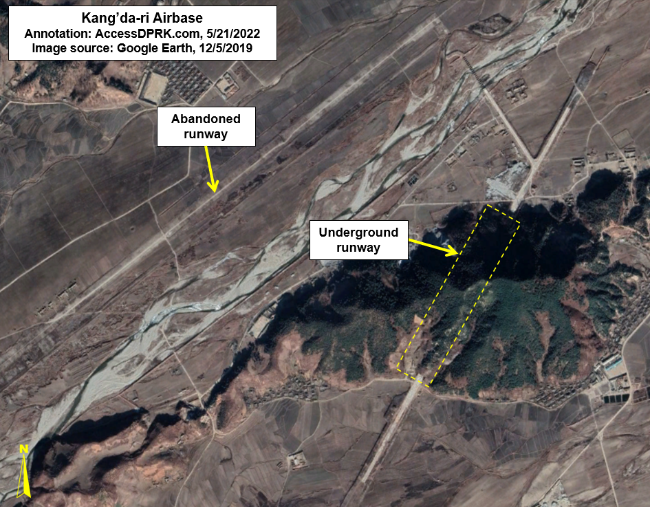
The country is also dotted with thirteen hardened and underground submarine bases as well as twenty air bases with underground facilities.


However, the underground submarine bases would likely struggle to accommodate North Korea's only nuclear-capable ballistic missile submarine, the Hero Kim Kun Ok Class which, at 86 meters in length, is 10 meters longer than the Romeo Class which was North Korea's largest submarine class. The Hero Kim Kun Ok instead is openly berthed at the Sinpo Submarine Base; its only defense against most forms of attack would be to take to the sea.
And since North Korea doesn't have an air-based nuclear delivery system, there are no nuclear-capable bombers to hit hiding in underground air bases.
In conclusion, North Korea has a widely dispersed nuclear program. That alone makes it a more difficult problem to address militarily. But, if the United States or some other country wanted to prevent North Korea from producing additional nuclear material, that could be accomplished through the use of Tomahawk missiles or other non-bunker busting munitions.
Although North Korea has a massive underground infrastructure, they have elected to put all of their most critical nuclear material producing facilities above ground.
At the same time, if the United States wanted to confidently launch a strike against the country and prevent North Korea from using their present nuclear arsenal, that becomes a much different proposition.
The number of potential hardened storage sites that would likely need to be hit would deplete the entire current inventory of GBU-57 MOPs, and even then, some sites would still exist. Without exceedingly accurate and detailed intelligence, the risk of striking North Korea's nuclear infrastructure only to have them fire a nuclear-armed missile back at the United States is too great.
The fact we haven't struck against North Korea's nuclear program suggests that the risks are indeed too great (both in terms of nuclear retaliation and the risk of an attack against Seoul) and that the intelligence is, more than likely, simply not there to adequately support such a wide-scale attack.
In my personal view, the last chance to kinetically engage was back in the early 2000s and maybe even 1990s. Bunker busting bombs or no, now that North Korea has a proven nuclear capability and numerous places to store warheads, missiles, and other equipment, even if such weapons could destroy any individual nuclear-related site, there is currently no way to guarantee North Korea wouldn't or couldn't launch a retaliatory strike from other locations.
I would like to thank my current Patreon supporters who help make AccessDPRK possible: Donald Pearce, David M., Dylan D, Joe Bishop-Henchman, Joel Parish, John Pike, Jonathan J., Kbechs87, Raymond Ha, Russ Johnson, Squadfan, and Yong H.