Thursday, June 4, 2020

Old School Fortifications Still Part of DPRK Military Plans

In this day of guided bombs, stealth fighters, and rail guns, North Korea is holding fast to World War II-style "practical" fortifications to keep their country from being quickly overrun in the event of an invasion.

After the Korean War, Kim Il Sung ordered that the country be made into an impregnable fortress. To that end, anti-tank walls, dragon's teeth, and concrete "fall barriers" (tank traps) were constructed all over the country, especially along the coast and DMZ to defend against invading forces.

The country's road system was also intentionally left in a poorly developed state to hamper the movement of heavy vehicles and tanks which would instead get stuck in the mud or squeezed into choke points to be picked off by North Korean forces.

Anti-tank "fall barrier" (German: fallsperre) located along the Pyongyang-Kaesong Highway in North Korea. Image source: Commons.

Some of these anti-tank fall barriers, which consist of concrete blocks stacked precariously on top of each other waiting to be toppled into the road to prevent tanks and other equipment from moving forward, are even placed at key points within the interior to protect mountain passes and other key transit sites.

While dragon's teeth and anti-tank ditches have largely been left to decay over the decades (with many sites being completely useless today), Kim Jong Un has continued to construct tank traps.

Another common fall barrier design. Image taken near the DMZ.


In 2017 with the publication of the #AccessDPRK Phase II Map, I had identified over 500 tank traps around the country - 198 were located near the Demilitarized Zone. Since then, I have located several others that I missed but I have also found a number of them that have been installed in just the last few years (while most others have been around for decades).

Map of all identified tank traps as of June 2020.

As the map shows, tank traps have been positioned along the DMZ and coastal regions to stall any invasion. Pyongyang is also protected by groups of them to the east and west (as the southern approaches are already protected by the DMZ).

Below are four new examples of these barriers that have been installed since 2015.

Near Kwaksan, a tank trap was added in 2015. It also includes a section of an anti-tank wall that runs for approx. 460 feet and blocks a small depression that tanks could have driven through to bypass the tank trap along the road.  Coords: 39°39'21.60"N 125° 0'3.08"E

Anti-tank wall and tank trap under construction on March 18, 2015.

The completed system as seen on April 1, 2017.


This one was built in Onchon in 2017 and reinforces another older road block 4 km away to prevent travel through the Cholhyon Pass of Mt. Sindok. Coords: 38°50'46.76"N 125°20'2.57"E

Four sets of blocks as seen on Feb. 27, 2019.


Two have been constructed near Myongchon. One in 2015 and the other in 2018. They block two points along AH 6 and is part of the main system of tank traps in North Hamgyong Province that defends the main transportation routes.

North trap (installed in 2015) - 41° 7'2.21"N 129°22'31.56"E


South trap (installed in 2018) - 41° 4'31.58"N 129°22'41.03"E


These are all similar to most other examples in the country and are meant to be able to block the width of regular country roads (which are predominantly unpaved). There are some examples of much larger road blocks, however.

This is a set of four blocks on the eastern approach to Pyongyang along the Pyongyang-Wonsan Highway. Since the road is wider than most, the blocks are taller; approx. 30 feet in height (compared to ~15 for most others).


I would like to thank my current Patreon supporters: Amanda O., GreatPoppo, Kbechs87, Planefag, Russ Johnson, and Travis Murdock.

--Jacob Bogle, 6/3/2020
AccessDPRK.com
JacobBogle.com
Facebook.com/accessdprk
Twitter.com/JacobBogle

Sunday, May 10, 2020

North Korea's Underground Navy: A Review


Many countries have underground facilities for their navies. Places to protect submarines, places to defend against surprise or nuclear attacks, underground storage, places that have all kinds of purposes.

One large example was the Soviet base in Balaklava, Crimea. China currently maintains at least six underground submarine bases. The United States has an enormous underground fuel storage site in Hawaii.

North Korea is no different.

North Korea has a tremendous amount of experience digging tunnels. I have found hundreds of tunnels across the country, hundreds of artillery sites that pop out of tunnels, scores of underground factories, and quite a few underground naval sites.

Bounded on two sides by the ocean and with 2,495 km of coastline, the Korean People's Navy has a strength of 60,000 men and over 800 vessels, making it one of the largest navies in the world in terms of vessel numbers. And while most of their naval technologies are decades behind the West, Kim Jong Un has been focusing on modernizing the fleet. Furthermore, what they lack in technology they can make up (some of that gap) by sheer numbers.

North Korea has 70-80 submarines, which places them on par with the United States (based on numbers) and far outpaces South Korea. Their navy has been able to inflict substantial damage in attacks like the Second Battle of Yeonpyeong in 2002.

And so, it makes sense to marry navy and tunnel together. Underground naval bases provide safety in the event of attack and secrecy to develop, arm, refuel, and launch attacks. Having multiple sites also makes it more difficult for an attacking country to quickly knock out North Korea's navy.

The country has 13 identified underground naval sites. Some can accommodate submarines but most currently serve various types of surface ships. Interestingly, North Korea's main submarine base for the Sea of Japan (East Sea), which is based on Mayang Island, lacks any apparent underground facilities.


(Click on images for larger view)

The facilities range from simple tunnels to more complex facilities that are accessed from the sea and cover a large footprint.

Starting with the Yellow Sea (West Sea) bases:

Taewha-do Underground Base: 39°25'59.69"N 124°37'2.39"E

Taewha-do is on an island (the -do suffix means island) and consists of a small underground facility and a turntable to enable vessels to be moved around the base on a short rail system. There is only a single dual entrance/exit point to the underground facility (UGF) but the island's size could theoretically accommodate an enormous UGF inside. However, it only appears to house small patrol boats and the island garrison is no larger than battalion sized.

Very little information about the base is publicly available and most of the information that does exist relates to a series of small military actions during the Korean War, before the UGF was construction. The island rises steeply out of the ocean and can provide up to 600 feet of solid rock on top of the UGF, giving it excellent protection.

Sok-do is not necessarily an underground base but rather it is a set of four hardened pens that allow craft to be protected. Located at 38°38'7.33"N 125° 0'26.27"E, it doesn't appear to be in use. It lies just 5 km from Pip'a-got, which is a primary naval base.


Pip'a-got is the largest naval base immediately outside of the West Sea Barrage, which cuts off direct access to the Taedong River and Pyongyang.

Pip'a-got naval base.

The base consists of a large protected harbor (created by a set of breakwaters), hundreds of buildings, and seven distinct ship handling sites (dry docks, main harbor, UGF, etc). It covers approx. 5 square kilometers.


The underground component consists of a 600-meter long tunnel that connects a turntable (that can take ships from a slip and bring them to the tunnel entrance) to an exit that enters directly into the sea, bypassing the large seawalls.

The tunnel could include other facilities like fueling, loading weapons, and repair, but the interior layout is not known. The hill it cuts beneath rises from ~90 feet at the turntable to a maximum height of ~250 feet along the path of the tunnel.

Sunwi-do & Sagot (Ryongho) Bases
Sunwi-do has a small base at the far northeast end of the island. It is across from the larger Sagot base on Ryongho Island 4 km to the north. Both bases are in South Hwanghae Province are the southernmost underground naval facilities on the west coast. The base at Sunwi-do lies a 31 km from the South Korean island of Yeongpyeong.

The base on Sunwi Island, 37°46'11.59"N 125°20'21.45"E

At its height, the island provides ~180 feet of rock over the Sunwi tunnel which runs for 250 meters.
North Korea has several classes of patrol boats and Sunwi seems to be a base for them. In the imagery provided by Google Earth, at no time has there been more than 13 ships and none over ~28 meters in length.

In this image of Ryongho, four classes of ship can be seen. Upwards of 36 ships have been seen at Ryongho but some may have actually been small fishing vessels along with the military craft.

Sagot base is split between two main facilities. One is at the town of Sagot, on the mainland 1.8 km to the north, and the second is the UGF on Ryongho Island (37°48'17.24"N 125°21'9.58"E).
A direct line from the Ryongho entrance to the exit runs 290 meters but the full tunnel path isn't a straight line. It is likely at least 365 meters in total length. Between 150 and 250 feet of rock sits above the site, depending on location.

The exit has apparently silted up and cannot be used as a direct exit point for sailing into the sea. Any vessel must be towed down the "hump" from the UGF exit point to the water. Why this hasn't been corrected would only be speculation, but it has been the case since at least 2004.

NK-01 antiship cruise missiles (a local variant of the Soviet P-15 Termit (aka Styx) are believed to be deployed at the base.

Along the northeast edge of the island is a series of small tunnels for terrestrial vehicles and other equipment. This is a common feature found at many bases across the country.

East Sea (Sea of Japan) Bases

Puam-dong is the first base on the east coast. (Going north to south, as I did for the Yellow Sea bases.) Located at 41°19'17.15"N 129°46'4.71"E it is a primary navy base and has a large harbor protected by ~470 meters of breakwaters.

The base has been called a submarine base (and some of its features support that conclusion) but no submarines are visible in the available imagery. Other vessels stationed at the base include the Sohung-class PTG (guided missile patrol boat). This has been a key base for them since at least the 1980s.


Puam-dong is divided into two sections because of a hill in the middle of the base. The main section has headquarter facilities, barracks, and other buildings. The second section (to the south) is for maintenance.

The tunnel runs for at least 425 meters and the hill provides ~270 feet of rock above. The base also has a small underground storage facility higher in the hills at 41°20'12.02"N 129°45'24.94"E.

Cha'ho is a major submarine base located at 40°12'18.28"N 128°38'59.31"E in S. Hamgyong province. Including the harbor, it covers approx. 7.7 square kilometers.


Development of Cha-ho began in 1961 and it was transformed from a small base for patrol craft to a major submarine facility. By 1968 the underground portion was under construction. Unlike many other bases, it has rail access.

Unlike land-based underground facilities, where large piles of debris can be seen and analyzed to yield the approximate volume of the UGF, sea-based sites tend to lack any visible debris (since it can just be dumped under water) making it almost impossible to determine its size or layout using traditional methods. (Technology does exist that can shed light on the internal nature of the site using special techniques, but those are beyond the reach of most.)

However, at least a portion of the quay positioned between the entrances of the UGF may be made up of excavated debris based on a review of declassified images.


Taking the curved shape into account, the tunnel runs at least 330 meters and is protected by upwards of 200 feet of rock. I suspect that the main tunnel is placed farther back than I have it drawn, but that's why things are labeled "approximate".

Throughout the base Sang-O class (mini subs) and Romeo-class submarines can be seen. Romeo's are Chinese built, Soviet originated submarines that North Korea first acquired in 1973.

Ryoho-ri (Toejo-dong) Base is the location of the East Sea Fleet Command. It goes by several designations, Ryoho-ri, Yŏho-ri (an alternate spelling), and Toejo-dong (the name of the bay and also commonly used). Its location is 39°52'33.92"N 127°46'43.45"E.


As if signifying the base's importance, one of North Korea's many leadership residences is adjacent to the base. Ryoho is also serviced by rail.

The base doesn't appear to have any shipbuilding capabilities, but it does have a small repair facility for patrol boats. As mentioned, it is the headquarters for the East Sea Fleet and commands all of the bases and associated facilities along the east coast. One of the subordinate units at the base is KPA Unit 158.

The underground facility follows the same basic design as all the others. Its tunnel is ~315 meters long and is covered by roughly 200 feet of rock.

Samil-ri is a small UGF that consists of a single entry point. Located at 39°22'18.03"N 127°26'18.43"E it is on a small peninsula that's part of the much larger Munchon Naval Base.

Across from it on the other side of the peninsula (over 900 meters away) is a turntable but it doesn't appear to have been used in years and the images available on Google Earth make it difficult to confidently assert that there's a tunnel connecting the two points.


It's hard to gauge how active this site is, particularly since the turntable doesn't appear to be in use, but the wider Munchon area has been the focus of a large modernization and expansion program which has been ongoing since 2014. The Munchon-Wonsan region is an important military and industrial area, and various improvement projects have occurred there including the Kalma International Airport, Wonsan-Kalma tourist zone, and the nearby Hodo missile test facility.

Of note, various materials can be seen at the entrance site in recent images that could be used in a restoration project.

Sindo & Yodo island bases

Sindo is a small, narrow island in Yonghung Bay, off of Wonsan. It has a small underground site but unlike Samil-ri it definitely doesn't have an exit point. It is located at 39°13'18.11"N 127°31'10.04"E and would have a maximum length of 85 meters (based on the particulars of the island). The island's garrison seems to be geared toward operating coastal defense artillery and is located nearly a kilometer to the east.

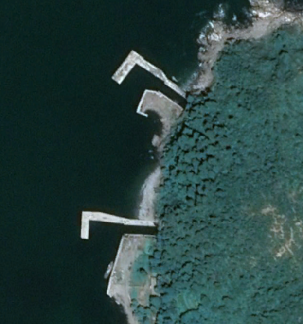
The Yodo island site is located 8.7 km east of the Sindo site. Like Sindo, it doesn't have a second entry/exit point, but it does have a turntable. This allows approx. 8 vessels to sit on the beach and then individually brought into the tunnel for servicing and then moved back out and onto the "holding yard".

If you look closely at the image, you can see a vessel halfway in (or out) of the tunnel entrance.

Yodo has a much larger garrison and even has a small grass runway that extends for 660 meters (although a dirt path cuts across it near the southern end). The naval tunnel may run for 180 meters into the hill to reach 140-150 feet of rock depth. Directly across is a hardened coastal artillery battery and those tend to have small tunnels connecting them to the outside. If we assume the tunnel comes close to the battery, then the tunnel may run as much as 200-230 meters.

Namae Navy Base

Located at 38°48'9.76"N 128° 8'18.58"E Namae is a large navy base with a breakwater that creates 38 hectares of protected harbor. The northern end of the base contains the underground facility. Namae has the facilities available to service all of North Korea's surface fleet and may be able to dock submarines.


The entrance is approx. 20 meters in width and could be covered by as much as 200 feet of rock. There does appear to have been an exit point built, but the tunneling work was either never finished or there was some other problem. An exit structure was built but is in a state of disrepair.

By 2013 a hole had appeared in the roof of the possible exit structure and by 2019 the roof had collapsed entirely. Had the entire facility been completed, the tunnel would have run 515 meters and would make it the second longest confirmed tunnel after Pip'a-got.

Possible exit structure with collapsed roof.

The last of North Korea's underground navy sites is at Changjon, 38°43'59.96"N 128°12'45.45"E.

It's the southernmost naval facility on the east coast and lies a mere 18 km from the military demarcation line.

Changjon is divided into two sections. The northern section contains a large active navy base, the southern section (~1.8 km away) has the underground facility but it appears to have been abandoned. No military vessels can be seen in Google Earth images (which go back to 2005), and there is a civilian dock with a floating restaurant just a kilometer away. It's part of the Kumgang tourism system.


At the same time, a small naval unit is still directly connected to it and the base did serve as a "frontline base for North Korean submarines" before being suspended as part of the creation of the aforementioned tourist zone. However, Kim Jong Un has recently expressed a desire to enlarge the base, so this portion of it may become active again in the future.


Additional reading:
Work on Major Hovercraft Base Advances, AccessDPRK, 1/17/2020


I would like to thank my current Patreon supporters: Amanda O., GreatPoppo, Kbechs87, Planefag, Russ Johnson, and Travis Murdock.

--Jacob Bogle, 5/9/2020
AccessDPRK.com
JacobBogle.com
Facebook.com/accessdprk
Twitter.com/JacobBogle

Tuesday, April 28, 2020

Kim Jong Un: Wanted, Dead or Alive


Kim Jong Un hasn't been seen in public since April 11. While the occasional absence isn't unusual, he missed the April 15 "Day of the Sun" holiday for the first time ever. The Day of the Sun celebrates the birth of his grandfather, Kim Il Sung, who founded the state. It's a very important holiday in North Korea and his lack of attendance sent the worldwide rumor mill into motion. Each day since has only added confusion and intensified the mystery.

Does he have coronavirus? Did he have a heart attack? Is being held hostage as his sister or uncle orchestrate a coup with the help of powerful generals? Maybe he's just tired of being in the spotlight all the time and needs a break? Or perhaps he was injured by flying shrapnel during an artillery exercise?

The speculation surrounding his health began in earnest when the DailyNK published a report based on a single unnamed source that claimed Kim had undergone a heart procedure at a special hospital based in Hyangsan and is recuperating.

Within about 48 hours, even reputable media descended into saying he was gravely ill or brain dead, and that a crisis was about to unfold. None of that, absolutely none of it, was supported by the initial report. Since then, some have even gone so far as to claim he's actually dead. And the usual suspects like Gordon Chang have jumped at the opportunity to stir the pot.

North Korea is already a very opaque state and they are not in the habit of publicly discussing the health of their supreme leader. Why should they? It would only invite internal dissent, discredit the idea that the Kim's are somehow special humans, and could court disaster from both within and without. So there has been no direct reference to either his health or whereabouts by state media.

With some notable exceptions, the international press has generally not made things any clearer. Their instance on speculation and running with the most sensationalist headlines has only served to make the waters more murky and caused many people a lot of unnecessary stress, as they add concerns over "lose nukes" to the already considerable stress caused by the global pandemic.

So what, exactly, are the facts? What do we know or at least what is most probable given the evidence?

Two weeks after his disappearance from public view, both the United States and South Korea have made claims that Kim is indeed alive and that he is staying at his seaside palace in Wonsan.

The general consensus of more rational media sources, unnamed officials, and official statements paints this picture: sometime in April Kim had a medical procedure and has since been resting in Wonsan.

Even the unverified claim that a Chinese medical delegation was sent in to help isn't unusual. From Muammar Gadaffi to Kim Jong Il, dictators with limited access to advanced medical equipment and expertise often seek the aid of foreign doctors. Indeed, Kim Jong Un was seen by a French doctor in 2014.

When it comes to what we know (or is most probable), that's basically it.

Lending support to that picture is the fact that commercial satellite imagery has shown one of Kim's armored trains parked at Wonsan since at least April 21. This also makes sense because in the original report from DailyNK, they said he had been recovering at a villa near Pyongyang immediately after surgery. After spending a week or so at that villa, he may be feeling well enough to venture to his favorite home.

Wonsan is not just the best equipped seaside residence in North Korea, it happens to be the place where Kim spent much of his youth outside of Pyongyang and Switzerland.

However, that alone is not conclusive evidence of anything as Kim is said to have at least three trains. His movements are always tightly guarded, and a second train will be used as decoy to help obfuscate his real movements (something he learned from his father). However, lending more credibility to the idea that he's in Wonsan comes from a report which cites an unnamed US official who said that Kim was spotted (via US reconnaissance aircraft) walking outside between April 15 and 20.

Additionally, Moon Chung-in, adviser to the South Korean president, has said that the official position of the ROK government is that Kim is "alive and well". As recently as April 27, President Trump has said that he knows the status of Kim and did not give any indication that he was dead or no longer able to govern the country.

It's important to remember that this is not the first time Kim has gone missing. He disappeared for about six weeks in 2014 after having an apparent procedure done on his ankle.

Kim Jong Un isn't the best example of health. Although he is only 36 years old, he is morbidly obese and is a heavy smoker. Adding to that is a family history of cardiovascular disease and stroke. So it's perfectly understandable for people to wonder about his health. What isn't normal is for journalists to gleefully speculate about his current condition as though it were fact.

There is nothing in any valid public source that would indicate anything more than he is in recovery.

And while I am personally content to read the tea leaves and wait until he shows back up (his dad went missing for nearly two months after his stroke), I am also getting tired of seeing extravagant speculation and rumor spreading. It may have made April slightly more exciting as I (like many of us) sit at home, forbidden to visit favorite restaurants or friends, but it has also consumed an inordinate amount of time to tamp down wild theories.

This is a view I believe I share with many other analysts. Yes, we're all very curious, but one can only say for certain what one knows. And the only ones who know much of anything right now are Kim Jong Un and his associates.

Dead or alive, it's only a matter of time before we know the facts. Turning what could be a simple heart procedure into a sordid dynastic succession struggle between Kim, his sister, and his uncle may make people click on links, but it does little to advance the cause of truth and violates the trust media, analysts, and other experts are supposed to engender.


I would like to thank my current Patreon supporters: Amanda O., GreatPoppo, Kbechs87, Planefag, Russ Johnson, and Travis Murdock.

--Jacob Bogle, 4/27/2020
AccessDPRK.com
JacobBogle.com
Facebook.com/accessdprk
Twitter.com/JacobBogle

Saturday, April 25, 2020

UN Report Shows Continued Illicit Oil Imports

Illegal ship-to-ship transfer of petroleum product between the Vifine and New Konk on June 19, 2019. (UN POE report, page 20.)

The 2020 United Nations' Panel of Experts (POE) report on North Korea's illicit trading activities has added further understanding to how North Korea has been able to continue building gas stations across the country.

Back in 2019 I did the first-ever survey (that I'm aware of) of DPRK gas station construction and it showed that at least 74 fueling sites had been built under the rule of Kim Jong Un. I have most recently been able to identify a total of 122 gas stations in the country (built before and since Kim Jong Un).

By examining the fueling tanks at a gas station in Wonsan, we can derive a rough estimate for how much gas would be required to keep all 122 stations operational if they were only required to be refueled once a month.


The tanks, located at 39° 8'32.42"N 127°23'8.17"E, are clearly visible on the Google Earth image dated Jan. 30, 2014. They are each approx. 32 ft long and 7 ft wide. That yields a volume of 1,231.5 cubic feet. For the sake of being conservative and to take into consideration the unknown thickness of the tank's walls, I am going to deduct 10% from that figure (giving us 1,108.3 cubic feet).

The weight of a cubic foot of gasoline is 46.75 pounds, giving each tank the capacity of 51,813 pounds of fuel (or 7,733 gallons at 6.7 pounds per gallon).

Gas stations have a variable number of storage tanks, some only have one and others have four or more. Simply assuming an average of two tanks for each 122 identified station, the country has the need for 1,886,852 gallons of fuel each month. If we use the 42 gallon per barrel measurement, then that's 44,925 barrels of gasoline needed each month, or 539,100 barrels annually just for vehicle fueling. There's still the need for aviation fuel and other petroleum products needed in transportation and industry.

North Korea is limited to importing 500,000 barrels of refined petroleum products each year.

The POE report says that the "aggregate amount of 500,000 barrels of refined petroleum products was exceeded many times over." (page 4). As part of the report, estimates from the United States suggest that North Korea imported anywhere from 3 to 8 times the legal cap (or 1.5 million to 4 million barrels of illegal petroleum).


The amount of petroleum being brought into the country would more than justify the continued construction of gas stations. Looking at fuel prices over time also suggests that the country is able to import (through whatever means) enough product to meet demand.

In Dec. 2018, fuel prices were around 15,000 won ($1.86) per kilogram. According to the most recent market trend report from DailyNK, gas prices had dropped to 11,500 won per kg. ($1.34) in April 2020. This also implies that trade in the most crucial supplies has not been severely affected by the coronavirus measures North Korea has put into place. Most trade has been stopped, but it was never fully ended and illicit activities continue regardless of the reported decline in legal oil imports from China.


I would like to thank my current Patreon supporters: Amanda O., GreatPoppo, Kbechs87, Planefag, Russ Johnson, and Travis Murdock.

--Jacob Bogle, 4/24/2020
AccessDPRK.com
JacobBogle.com
Facebook.com/accessdprk
Twitter.com/JacobBogle

Wednesday, April 15, 2020

City Planning in the DPRK

Downtown area of the reconstructed Samjiyon. Off in the distance is a bronze statue of Kim Il Sung and "revolutionary history" museums at the base of the hill. (KCNA, 2019)


Plenty of people are familiar with Pyongyang and even other major cities in North Korea, but most of the population lives outside of the capital, Wonsan, and Sinuiju. Car ownership is still rare in North Korea, so even in Pyongyang, it doesn't take very long to find yourself on winding, narrow dirt paths. But the layout of streets is only one part to city planning.

The majority of the housing, stores, and schools in my hometown is in an area roughly 5 x 5 miles. That's a city with about 150,000 people. There are 14 North Korean cities with a population of 150,000 or greater. Excluding Pyongyang, the urban areas of those other 13 cities all fit within an area smaller than 5 x 5 miles.

And even Pyongyang, with 2 million people living in the main urban area, only occupies about 67 square miles. That is almost the same area as the federal district of Washington DC, which has a third of Pyongyang's population. This underscores the realities of how densely cities develop when cars aren't the "driving force" vs. how cities grow when vehicle ownership is viewed as a personal imperative. The result of that is North Korea lacks a lot of the urban sprawl that plagues many other countries.

Main urban area of Pyongyang.

Where you place important buildings, markets, or stadiums, it all matters, and it all says something about what the people and government find most important. This is all the more important when you're dealing with a walking and biking population.

City plans place what is important to the regime in the center and then from there follows places that would be important to the people (like small business districts that may have stores, a restaurant or two, and maybe a small hotel). To help us understand the overall city planning fundamentals in North Korea, I am going to detail two county seats, a smaller town, and then an even smaller village.

County seats follow two general layouts. A compact core of civic buildings and monuments around central plaza or a more spread out design where citizens encounter reminders of the state at multiple points throughout the city. The main difference between county seats and provincial capitals is that each provincial capital will also host large, bronze statues of Kim Il Sung and Kim Jong Il. Otherwise they tend to simply be enlarged versions of county seats with more industrial sites, more local businesses, and the occasional university.

Kophung, Chaggang Province is an example of the "compact" design.


As you can see, the main roads of Kophung channel people passed important reminders of regime power like the Juche Study Hall and the Tower of Immortality. The town hall is, of course, centrally located as well. Another thing to note is how far away the marketplace is.

While it's certainly within walking, it has been placed on the outskirts of town, something that is repeated in many of other locations. This is because most markets began as unofficial, even illegal, gatherings of people trading, bartering, buying, and selling. Some would be little more than an open area of ground where people would bring their goods, while others had small tents or other temporary structures placed at the site during the day or two the market was open.

As markets were slowly incorporated into the daily lives of most citizens, they became tolerated and then eventually regulated by the state. This allowed permanent structures to be built and they tended to be built where the informal market was already located - in the outskirts or other less desirable places.

Generally speaking, markets are also located some distance away from any key state symbols (like monuments), as they are somewhat regarded as an ideological stain (albeit one to accept). You can't have a blazing example of capitalism and individual freedom next to a monument to the communist "Sun of Mankind", Kim Il Sung.


In this close-up image, you can see that the line-of-sight from any direction you come, lands on the Tower of Immortality. These were first erected following the death of Kim Il Sung as monuments to his life and to reflect that his spirit will always remain. Indeed, Kim Il Sung is legally the "Eternal President" of the DPRK. The inscriptions on the towers were changed to include Kim Jong Il after he died. He is the "eternal" General Secretary of the Korean Workers' Party.

Additionally, every county seat (and provincial capital) have joint murals of Kim Il Sung and Kim Jong Il. During my 2018 survey of the country's monuments, I was able to identify 5,175 Towers and 265 joint murals.

Like elsewhere in the world, cities will usually keep their small industrial sites away from the city center. Many county seats also lack a stadium or dedicated sports field, but they will use the fields at schools. For those that do have a stadium, they are likewise set out away from the urban core.

Sepo, Kangwon Province is an example of the "spread out" design.


With the city of Sepo, the regime-focused structures are spread throughout the city, instead of in a single cluster. From the image's perspective, moving north from the train station (which is how most people arrive into town), there is a direct line of sight to the Tower of Immortality, and from there, to the town hall.

If someone travels down either of the main left-to-right roads, the joint murals will be visible at one end and the Juche Study Hall at the other (which happens to be surrounded by two grade schools. One is marked in the above image and the second is marked on the image below).


Every town has at least one "Juche Study Hall", they go by a number of different names including, palace of culture and Kimilsungism-Kimjongilism study hall. These basically play the equivalent role of churches in Europe and the Americas in centuries past. Centrally located, this is where people are required to go multiple times a month (at least) to be indoctrinated in the latest Party orders, to learn about the exploits of the leadership, and to hold "self-criticism" sessions.

Instead of struggling through alcoholism and freely talking about your journey in a safe environment, as in Alcoholics Anonymous meetings, self-criticism sessions could be described as meetings holding each other accountable for "wrong thought". But it goes much further than that. Everyone fails Kim Jong Un. Everyone holds thoughts incompatible with Juche. Everyone didn't try hard enough to study their best or to meet their quotas during work. Everyone fails and everyone is expected to come up with something to confess, whether or not they really did it.

And instead of being supported by their community, they are shouted down or accused by everyone in the group. These sessions can last hours, and defectors have spoken about the emotional trauma they cause.

Hwanggang-ri, N. Hwanghae Province is an example of a smaller town (38°20'16.79"N 126°47'8.90"E)


Hwanggang-ri is a small town with fewer than 2,000 people in the immediate area. It has a single, combined school where the elementary school and high school are within the same complex. From the perspective of this image, to the north of the Tower is the town hall and below the Tower label is a row of four buildings.

Each North Korean town has a medical clinic. Unlike schools or Juche buildings, these clinics don't always have a uniform style that is easily identifiable from satellite images. (Large hospitals are more easily discernible, but they're only in large cities anyway.)

In some places, the clinic is located inside the town hall and in others, a stand-alone building exists for the clinic. These clinics only offer basic health care functions, similar to a walk-in clinic that a pharmacy might have in western countries. They can diagnose a cold, give you something for a fever, stitch up a cut finger, or pop a shoulder back into place. They are not for MRIs or open-heart surgery. And given the state of North Korean healthcare overall, you probably won't find any antibiotics readily available, either.

A town this size is large enough to have a clinic, but whether it's in the town hall or in one of those four buildings, I can't say.

Unphyong-ri, Chaggang Province, is an example of a small village (40°52'51.36"N 125°46'20.17"E)


Even in small villages with only a couple hundred people, where having a separate building for Juche studies doesn't make sense, there is still a Tower, a town hall, and a school nearby. That simple organizational style is repeated in almost every populated place in the country. Only the smallest hamlets lack these things.

In the most rural parts of the country, schools are simple and may require a long walk, but it underscores the importance of basic education. Most students may only receive a limited education, but reading and basic math are fundamental to any functional society. 


As we have seen recently with the city of Samjyon, cities can be completely redesigned, demolished, and then rebuilt in the new design on the whim of the country's leadership. And many larger cities have had parts of their cores rebuilt or modernized at the direction of Kim Jong Un and through the national Korean Workers' Party. But local additions must be requested, approved by higher authorities, materials assigned, and then finally the buildings can be constructed. This means that a village might not see a single new home or even a repaired home for many years. Indeed, no new homes are visible in Unphyong-ri since 2009 and only two new homes were built in Hwanggang-ri since 2002.

And as we have seen here, no matter the size of the locale, there will always be a recognizable pattern in the plans of each city and village. They will place regime buildings and monuments in high visibility areas, schools will (often) be nearby, and signs of capitalism will be pushed to the side if possible.

Additional reading
A brief urban history of Pyongyang, North Korea - and how it might develop under capitalism, The Architect's Newspaper, by Dongwoo Yim, Aug. 24, 2017

I would like to thank my current Patreon supporters: Amanda O., GreatPoppo, Kbechs87, Planefag, Russ Johnson, and Travis Murdock.

--Jacob Bogle, 4/14/2020
AccessDPRK.com
JacobBogle.com
Facebook.com/accessdprk
Twitter.com/JacobBogle

Sunday, April 5, 2020

Kim Jong Un's Green Agenda

Workers cleaning rooftop solar panels on a building in Pyongyang. Image: KCNA, 2019

North Korea is a land full of bucolic views and industrious people. It also suffers from river pollution, air pollution in Pyongyang, and a never-ending shortage of electricity, which hampers every aspect of domestic and industrial life.

Most countries have embarked on developing a green economy and a green energy supply to fuel economic growth. This has been spurred on by the dangers of climate change and the realization that easily accessible fossil fuels are getting harder and harder to find.

To address climate change, every country on earth (including North Korea) signed the Paris Agreement. Long seen as an outsider to the global community, North Korea is still a signatory, whereas the United States has pulled out.

And to address ever growing energy needs, the world has heavily invested in renewable energy sources. Since 2000-2001, global consumption of traditional fuels fell from 12,500 TWh to 10,895 TWh (as of 2017). In the same time frame, consumption of renewables like hydroelectric, solar, and wind more than doubled from 2,817 TWh to 6,232 TWh.

While North Korea is technically classified as an industrialized country, most of the people live in poor economic conditions. Other countries face similar problems. They have a growing population and a need for more electricity (but at levels that still fall far behind western countries). At the same time, they often lack the funds to build advanced and cleaner versions of coal plants which can cost many billions of dollars, and they lack the healthcare infrastructure needed to address the illnesses associated with mining and burning fossil fuels.

And this is where the drive to fight climate change and the drive to improve energy and economic conditions merge. In per capita terms of "kilograms of oil equivalent" North Korean's use approximately 1/15th as much energy as Americans. This means fewer TVs and energy intensive refrigerators. It means that homes outside of major cities may only have a radio, a few light bulbs, and an electric rice cooker. Thus, these homes don't require huge sums of electricity, so many are turning to solar and going "off the grid".

After generations of focusing on massive energy producing projects, North Korea seems to be switching tactics and creating a patchwork energy grid. Large coal and hydroelectric plants to service primary industry and the major cities, and smaller hydroelectric dams along with limited solar and wind to support less populated areas. As for the individual, they're also getting into the act as mentioned above. This network has the potential to greatly ease the country's electricity problems as well as address matters of climate change.

North Korea's behavior isn't only changing how it gets electricity, but it is also tackling longstanding problems with deforestation, and the floods and landslides they bring. Combating this problem will not only affect the environment but will also help alleviate food shortages and enable the government to spend money elsewhere, instead of rebuilding cities after major floods.


Wind Power

Two wind turbines at Ongjin, dated Nov. 25, 2019.

One of the oldest wind farms in North Korea is near the Ongjin Airfield and consists of two separate  groups of two wind turbines. Both sites have existed since at least 2009.

In 2009, the Korean Central News Agency reported that thousands of home-use wind turbines had been installed around the country. There is some photographic evidence for this, but little satellite-based support. Unfortunately, these turbines are indeed very small and may not be visible in most commercial satellite imagery, so it is difficult to independently gauge just how widespread home-based installations are.


There are at least four other wind farms in North Korea. The newest installation I could find is in the rebuilt city of Samjiyon. There is also a small solar farm, and both are located at the top of the ski resort.


Changes in hydroelectricity production


North Korea has its share of relatively large hydroelectric dams, with some dating to the Japanese colonial era. Several run along the Yalu River at their northern border and others are located inland like the Songwon Dam and Ryesonggang Youth Power Station No. 1. However, North Korea's attempts to build large hydroelectric dams have run into many problems and delayed construction. The final results rarely yielding the levels of electricity generation expected. Other smaller, older hydroelectric facilities (like along the Taedong River) have also fallen short of their generating capacity and are now primarily used during planting and harvest seasons to assist in irrigation and powering up agricultural facilities.

In the last decade, Kim Jong Un has been carrying out "new" agendas that were initiated by his father, and shifted the country's hydroelectric plans toward more small and medium-sized hydroelectric facilities that can also better control river flows and water supplies for irrigation.

These projects include multiple dams along the Ryesong River and the Huichon series along the Chongchon River. There was also an effort to build scores of "low-head" power generating stations that pre-dates Kim Jong Un's efforts but have proven the effectiveness of smaller dams and generating sites in adding up to lots of energy generation while not requiring vast sums of material, and they can be built in less than optimal river systems (located primarily in South Hamgyong Province).

One of the most recent hydroelectric series to be completed is the Paektusan Hero Youth Power Stations. Other series that Kim Jong Un managed to complete have been the Wonsan People-Army Power Stations and the Wonsan Youth Power Stations which have six generating plants between them.


Combined facilities


A great example of the push toward renewables is the KPA Air Force Unit 1016 combined wind-solar farm, located near Kawil, S. Hwanghae Province. Initially it was just a wind farm with three medium-sized turbines with construction beginning in 2010. In 2015, a 5,545 sq. meter solar farm was added to the site. It is the largest combined facility in the country.


A second facility is located along the 4.6 km long conveyor system of the Unnyul mine and associated land reclamation project. This facility only has a single wind turbine, but its solar farm is larger than Kawil's at a little over 18,000 sq. m. Primary construction was carried out from 2015 to 2016, and the site powers eight apartment blocks and a dozen or so other buildings, as well as an industrial site.


Reforestation efforts


Before and after images of tree replanting efforts from 2003 and 2018. In the bottom image you can rows of planted trees in the formerly bare hillside.

Deforestation has been recognized as a major contributing factor to flooding and the 1990s famine by the regime since the days of Kim Jong Il. Denuded hillsides can't hold on to soil, making landslides more common and increases runoff into rivers - choking them and killing fish in the process. Fewer trees mean an increase in top soil depletion and airborne dust. And fewer trees mean a lack of needed firewood and decreases the richness of local ecosystems. People rely on native herbs, fungus, and small animals for food and commerce, and without forests, those ecosystems and opportunities disappear.

Between 1990 and 2005, North Korea lost nearly a quarter of its forest cover and it has become a major problem. While the country is still experiencing a net loss of tree cover, there is now an ongoing effort to replant trees.

In 2015 Kim Jong Un gave a speech on reforestation efforts. In his speech he recognized that uncontrolled deforestation has been ongoing, that there has been a lack of preventative measures to stop forest fires, and that "as the mountains are sparsely wooded, even a slightly heavy rain in the rainy season causes flooding and landslides and rivers dry up in the dry season; this greatly hinders
conducting economic construction and improving people's standard of living..."

Tree planting efforts date to 1946 with the annual "Tree Planting Day" each March, but there is little evidence that these single day events did much to ameliorate the situation during the rapid deforestation that occurred in the 1990s or to replant meaningful numbers of trees since then. Kim Jong Un's critical recognition of the problem, however, is a sign that the state is going to take the problem of deforestation and wildfires much more seriously, especially considering the mix of both extreme drought and damaging floods the country faces - which tree cover levels can play a major role in.

In Kim's 2015 speech he gave a ten-year goal to reforest the country's mountains. Efforts to achieve this goal includes the establishment of scores of tree nurseries across the country that can, theoretically, produce 20-25 million trees annually. The regime has also begun to crackdown on the illegal private farms that dot the hillsides and have played a role in deforestation and soil degradation.

Nurseries have indeed been constructed. How well those trees are later transplanted and able to mature is left to be seen.


Conclusion

As international relations expert Benjamin Habib has said"The North Korean government would appear to have a compelling prima facie self-interest in participating in the global climate change mitigation and adaptation project centered on the UN Framework Convention on Climate Change (UNFCCC)" as growing environmental issues can threaten the survival of the regime.
Indeed, a 2019 report by NK News pointed out that climate change threatens the very existence of the northern port city of Sinuiju by 2050.

Unfortunately, the actions taken have been a patchwork of activity, generally lacking coordination or broad national action. Additionally, the main focus doesn’t necessarily seem to be creating a better environment for the people, but rather these changes are pragmatic decisions to help accomplish industrial and military goals, that happen to have other benefits.

While investing in renewable energy sources, allowing individuals to go their own way regarding solar water heaters, etc., are obviously beneficial, the problem of pollution still exists and there are few overt plans to change that reality.

Though new trees help stabilize the ground and protects farmland, hundreds and hundreds of acres of farmland are situated on highly polluted soil, such as on former coal ash ponds, leading to contaminated food. Two large examples of this can be seen at the Pukchang Thermal Power Plant and adjacent to the Namhung Youth Chemical Complex near the city of Anju.

And while mixing up the country's energy portfolio with renewables will have an impact, the country's coal-plants still spew out tons of air pollution and release toxins into rivers. North Korea's nuclear development and industrial sectors likewise negatively impact large swathes of the nation and the people who call it home.

Even actions taken by the government to increase the food supply by reclaiming tidal flats and converting them into farmland will not be sustainable without mitigation efforts, as sea levels rise and saltwater contaminates ground water. And if the West Sea Barrage comes under threat, Pyongyang itself could suffer the direct effects of sea level rise in the future.

As the effects of global warming become more pronounced, the Kim government must take a serious look at how they can accomplish their more immediate goals of militarization and creating an adequate energy supply in the light of what impact they may have on the overall health of the people, and the state's role in either contributing to or helping to limit climate change.

Countries with major coastal cities and those with limited economic power face the greatest challenge. As laudable as these changes are, without taking the threat more seriously and without creating a more open diplomatic environment to allow for future international aid, North Korea is unlikely to achieve energy independence and may be very hard hit by the growing realities of climate change.


I would like to thank my current Patreon supporters: Amanda O., GreatPoppo, Kbechs87, Planefag, Russ Johnson, and Travis Murdock.

--Jacob Bogle, 4/4/2020
AccessDPRK.com
JacobBogle.com
Facebook.com/accessdprk
Twitter.com/JacobBogle

Monday, March 23, 2020

Abandoned Projects of the DPRK

A lot of attention is given to the various plans and policies of North Korea. From Kim Jong Il's songbon (military-first) to Kim Jong Un's byungjin (duel-path focusing on nuclear and economic development), each time a new declaration is made many people tend to overreact as though they're somehow distinct or substantially different from the previous policy.

The fact is, they're all variations on a theme. The byungjin policy promulgated by Kim Jong Un is little different than national policies set out by North Korea's founder, Kim Il Sung.

Simultaneous focus on light industry and energy, focus on feeding the people and building nuclear weapons. It all boils down to this: keep the economy going and maintain the military. In classic Stalinist style, these kinds of policies either do little in reality or take an inordinate amount of time to achieve.
They rely on the mass work of millions and the ramping up of efforts in one sector only to lurch to some other area. And in the process, an enormous amount of inefficiency shows up and completely wasted effort is expended. Adding to the inept economic planning of the last 75 years is the fact that none of these policies acknowledge the strain prestige projects add to the system.

The country has spent combined billions on empty mega hotels, palaces for the dead, and trying to "save face" by competing with South Korea in ways that ended up making the 1990s famine even worse (such as the case of the 13th World Festival of Youth and Games which consumed a quarter of the country's entire budget).

Naturally, this means the country is littered with abandoned or half completed projects as the country's direction is moved from one focus to another, often with little regard for sound economic or military principles.

Ryugyong Hotel

The "Hotel of Doom" as seen from the Yanggakdo International Hotel in 2012. Image: Commons/Nicor

The most well-known abandoned project is the Ryugyong Hotel in the middle of Pyongyang. Construction began in 1987 and it was intended to be completed for Kim Il Sung's 80th birthday in 1992. Lauded as the soon-to-be "world's tallest hotel", construction was never finished, and it sat for many years as little more than concrete and steel shell. This helped earn it the nickname "Hotel of Doom". The collapse of the Soviet Bloc dried up foreign investment in North Korea as well as put an end to imported construction materials that had been sold at discount "friendship prices". By the time work halted in 1992, some estimates place the price tag at $750 million.

Two years later a famine began, and a million North Koreans died of starvation and related illnesses. The hotel was such a failure that in some images of the Pyongyang skyline, officials altered the pictures to remove the building. It was basically ignored and soon "officially" never existed, its giant corpse looming over the grey capital of a grey and dying country.

It wasn't until 2008 that construction resumed with a $400 million investment from an Egyptian company. By 2011 the exterior was finally clad in glass and, from a distance, it at least looked like it was completed. However, as many international firms have learned, trying to do business with North Korea is extremely difficult and initial costs often far exceed the original estimates. The building has structural problems, the regime can't produce the quality materials needed, and the building still sits unfinished and empty. The biggest change since 2011? The addition of LED lights to the outside that can produce light shows. $1.1 billion spent on a hotel, just to get light shows.


New hovercraft bases come to a crawl

Under Kim Jong Un, North Korea has been investing huge sums into their conventional (non-nuclear) military forces. This has included expanding their ability to project force using the country's fleet of hovercraft.

Hovercraft offer the regime the ability to rapidly attack South Korean bases and other targets, and to insert special operations forces while limiting South Korea's time to fully react.

The unfinished hovercraft base at Manghae-dong.

The biggest of the new bases is at Yonbong-ni, along the Yellow Sea (West Sea), but work has been slow going. The military established two other future bases as well. Their stories are even less successful.

Nearby Yonbong-ni is Manghae-dong. The first signs of construction appear in 2015 and by 2018, sixteen hovercraft housing bays were under construction. The beginnings of a "sled way" to allow the craft to go from land to the sea is also visible.

However, by the end of 2019 very little new work has been done and much of the site looks abandoned. Further evidence of this is the fact that most of the temporary workers' housing has been removed.

The abandoned housing bays of the San-go-li hovercraft base.

A facility at San-go-li (in Kangwon Province) has fared even worse. While Manghae still exhibits a little life, Son-go-li has been completely abandoned.

While the initial excavation of ~19 housing bays began in 2015-2016, that's as far as things went. The latest image from Google Earth shows the place abandoned and the bays flooded. In the meantime, a new coastal hotel was constructed 0.8 km away.


Highways

North Korea has a notoriously bad road network. A road trip that might take an hour or two elsewhere, could end up consuming an entire day in the DPRK. Part of this because they lack the money for infrastructure and part is actually on purpose. If you have few paved roads and lots of dirt paths, it makes it awfully difficult for an invading army to quickly move along.

However, there have been attempts to improve the country's road network. Some of them have been successful and other plans have been left by the roadside. One such abandoned project was an extension of the Pyongyang-Huichon Highway (HWY 65) near the historic city of Hyangsan.

Hyangsan sits at the base of Mount Myohyang, which plays an important role in Korea's mytho-historic past, and is where the International Friendship Exhibition is. Huichon is 17 km away.
Huichon is an important industrial and military city, and is the second largest city in Chagang Province. Thus, ensuring rapid transit from the city to Pyongyang would be an important goal.

Abandoned rows of piers. Google Earth, Dec. 6, 2019.

The bulk of the 4-lane highway coming from Pyongyang was constructed in 1994-95, but stopped at Hyangsan, where it shrank to a winding 2-lane road. Coming south from Huichon, the smaller section of the planned 4-lane highway was actually begun in 1990 but was never completed. Bridge piers sit stranded in fields, and hills have large scars from the excavation work, but no road exists. The abandoned section would have been 21.5 km long and take a mostly straight path. The current 2-lane route follows the Chongchon River and adds several kilometers to the trip.

Land reclamation


North Korea is very mountainous and less than 20% of available land is arable. But the country does have 2,500 km of coastline with vast tidal flats in the west, and that means opportunities for land reclamation.

The projects typically involve blocking off tidal flats from the sea and allowing river sediment to backfill the area or taking a more direct approach and manually filling in the land with countless loads of soil. Another process is connecting nearby islets with dams/barriers to enclose an area and having it filled.


Combined, these projects have accomplished adding over 260 sq. km. of land and proposed projects would add dozens more. However, a lot of these projects have been stalled or abandoned.

The Ryongmae Island Project was supposed to yield 3,676 acres of new farmland. Initial reclamation attempts even go back before 1985, but there has been little progress.


Ironically, there is some debate as to the caloric value of reclaiming coastal land to grow rice. It may be that there are more calories and protein in the countless small fish and crustaceans that otherwise live in these areas than the country might yield growing rice.

Power plant

North Korea has struggled with electricity generation for decades. It has several large thermal power plants (each working at varying degrees of efficiency) and scores of hydroelectric facilities, but they're inadequate to the task and very few places in the country can count on electricity all day, every day.  Hurried construction based on arbitrary timelines (such as political anniversaries) also results in flawed construction and inevitable delays, meaning they're always playing catching up.

To try and address the electricity problem, the regime began constructing a new coal powered plant near the village of Samdung, south of Kangdong. Construction began in 2011 and carried on through 2013, at which time construction came to a halt. Seven years later and no progress has been made.

Abandoned Samdung power plant. Google Earth, April 21, 2019.

Recreation

Even when it comes to letting people have fun places to go to, internal politics results in millions of wasted dollars.

The Pyongyang Folklore Park was a microcosm of North Korean identity. It had replicas of ancient palaces, a scale model of Mt. Paektu, and many other attractions. Construction began in 2008 and was mostly completed by 2013. It was Kim Jong Un's uncle, Jang Sung-taek who allegedly managed the project and helped make it a reality. Kim had Jang killed on Dec. 12, 2013 for a myriad of reasons.

Pyongyang Folklore Park near completion. Google Earth May 3, 3013.

As Kim Jong Un consolidated his power and once he felt secure from the ghost of his once extremely powerful dead uncle, he closed the 80-acre park in 2016 and began to demolish it. All that remains today are piles of rubble.

The park's remains. Google Earth, April 11, 2019.


There are many other examples of abandoned projects and ones that were sidelined while the nation's entire output of construction materials was sent to one or two specific sites (like new Wonsan resorts and the rebuilt city of Samjiyon). This behavior highlights the inefficiency of command economies and shows just how vulnerable the people are to the whims of Pyongyang.

At the same time, other projects have been under construction for decades, as work progresses in fits and starts, seemingly without reason. Two interesting examples would be the Hagap Underground Facility and the Kangda-ri underground runway.

However, despite all of this waste and the suffering it prolongs, the country's economy and military has advanced ever so slowly. Kim Jong Un does seem to have been able to pull many disparate threads into something quasi-functional. It must be said that his rule has been more effective than that of his father's; unfortunately, it has been just a cruel.


I would like to thank my current Patreon supporters: GreatPoppo, Kbechs87, Planefag, Russ Johnson, and Travis Murdock.

--Jacob Bogle, 3/22/2020
AccessDPRK.com
JacobBogle.com
Facebook.com/accessdprk
Twitter.com/JacobBogle