Thursday, October 15, 2020

North Korea's Airborne Training Sites

Similar to the parachute jump towers in North Korea, this image of one at Fort Benning, USA provides up-close detail. | Image: U.S. Army, 2013.

North Korea's air force is aging as is much of their military equipment. At the same time, North Korea has been making up for these deficiencies by increasing training and readiness, particularly for their special operations forces. According to US Army Operations Officer Samuel Allmond, "North Korean airborne [special operations forces] are elite, highly trained, highly skilled and highly adaptable light-infantry oriented forces," and are trained "for both medium altitude and low-altitude jumps behind enemy lines."

Parachutist training first began in North Korea in the early 1960s and by 1968 there were at least two known airborne units. From then until the death of Kim Jong Il, training centers had been established in Koksan, Pyongyang (Songsin District), Sangwon, Taetan, Taechon, and Unsan. 

Under Kim Jong Un, four new ones have been constructed and three of the older facilities have undergone new construction and other improvements. 

The new ones are located in Changdo (built in 2014), Pyongsan (built in 2015), Sonchon (built in 2014-2017), and Unsal (built in 2012-2014). The facility at Sonchon was only brought to the public eye in 2020 by Nathan J. Hunt. The previously existing sites that have been upgraded are at Taetan, Taechon, and Unsan.


Map of North Korea's parachutist training centers. | Image: Jacob Bogle

Today, these ten facilities aid in training the seven known paratrooper units in the country. Four units are part of the Korean People's Army and three brigades are under the KPA Air Force.

Army
26th Air Landing Brigade
38th Air Landing Brigade
45th Air Landing Brigade
525th Special Operations Battalion

Air Force
11th Airborne Snipers Brigade
16th Airborne Snipers Brigade
21st Airborne Snipers Brigade

According to Joseph P. Bermudez' 2001 book Shield of the Great Leader: the armed forces of North Korea, within the various special forces units there are three airborne brigades, three air force sniper brigades, and five other sniper brigades that may or may not take part in parachute training. The six airborne and air force brigades he mentions total 21,000 personnel.  

Whether the addition of new training sites under Kim Jong Un reflects the creation of new military units, the transfer of personnel from non-airborne units to existing airborne units, to aid in training other related and auxiliary troops, or simply a desire to improve overall training capacity, I don't know.

What is clear, however, is that North Korea is placing a great deal of importance on both their special operations forces in general and specifically on airborne (be they special forces or not). 

Some of the training facilities are very near airbases while others are not. This could reflect which ones are attached to the KPA Air Force and which ones are Army. 

I also want to stress that airborne forces are only one prong of North Korea's elite and special forces. As well as being delivered by air, they can infiltrate South Korean targets by hovercraft, submarine, other landing craft, and even tunnels. 

Changdo (38.650° 127.745°)


Changdo is located in Kangwon Province, about 36 km from the DMZ. It is a large training base surrounded by mountains and has existed for decades. However, in 2014 a "jump tower" was added to go along with numerous firearms ranges. Additionally, from 2012 to 2019, twenty-two new barracks buildings were constructed, and other changes were made to the base as well.  

In keeping with the upgrades of North Korea's nuclear and conventional forces, an apparent urban warfare training site (or MOUT, military operations on urban terrain) was built in 2019 in the southeast of the base. Presently, the whole base covers over 5.6 sq. km.


Traditionally, these towers are between 11 and 61 meters in height. The smaller ones are basically used for someone to jump off of a raised structure while strapped to a harness to experience the sensation of a jump, while the taller ones are high enough for a parachute to expand and are used by troopers during the last portion of their training before jumping out of a real aircraft.

I haven't been able to positively identify any of the smallest towers or other structures like the lateral drift apparatus. I have come across a few examples that may be them, but I am not certain. As such, I will only be pointing out the larger towers.


Koksan (38.658° 126.666°)


The Koksan training base is located in an area with multiple runways of varying types. The most important is Koksan Airbase 6 km to the west of the training base. There is also the Chik-tong Airfield, an auxiliary runway adjacent to Koksan AB, two additional airfields, and two emergency highway strips

Only the Koksan AB has a paved runway, the rest are simply grass fields or compacted dirt (such as the highway airstrips). While these other landing strips aren't meant for regular fighter jet use, they can all accommodate the country's large fleet of An-2 biplanes. These Soviet-built planes can fly low, have a small radar cross-section, and are a keystone for North Korea's special forces.

The idea behind having these antiquated planes is to allow reconnaissance and to infiltrate behind enemy lines during the opening stages of a new war. 

"During the dark of night, as part of the opening throws of a battle royale between South Korea, the U.S. and North Korea, hundreds of these old radial engine biplanes will fly low over the ground at slow speed, penetrating deep into South Korean airspace. For the vast majority of their crews it will be a one-way mission—to deliver Kim Jong Un's hardest shock troops deep behind enemy lines. This is done via low altitude air drop, as seen above, or by landing in short stretches of fields or roadways." -- Tyler Rogoway, The Drive

The Koksan training base's proximity to all of these runways makes a lot of sense regarding training parachutists to operate on a wide range of landing sites and terrains (as the area has low-lying mountains, open agricultural plains, and even small reservoirs that could assist in training for water landings).

A closeup of the jump tower. Its lattice structure can clearly be seen and the three arms from which recruits are dropped to the ground (landing zones) are also visible. 

In contrast to the concrete tower at Changdo, Koksan's tower is a steel lattice tower, like the one pictured at Fort Benning. Only one of the newly built towers is also a steel lattice. The rest are concrete. This reflects a trend to either build concrete towers or to modify the older steel towers (as was the case with Taetan and Unsan).


Pyongsan (38.400° 126.373°)


Similar to Changdo, the tower at Pyongsan lies within an older (and large) training facility. The concrete tower was constructed in 2015 and it is within a section of the base that includes water obstacles and an urban warfare training site (MOUT). 

The whole base occupies approximately 10.2 sq. km. and has a substantial administrative section, a driver training section, and apparent economic facilities (like farming and making agricultural products). 

The military is heavily involved in the country's economy and, in effect, creates its own parallel economy to the national one. So it is not unusual for large bases to be involved in either farming or manufacturing with intent to sell their products overseas to earn hard currency for the regime. And nearly every military site, large and small, has converted some of their land into farms to help feed the people stationed there.  

The nearest major airbase to Pyongsan is Nuchon-ni, some 29 km to the southwest. That, the fact that there is a MOUT facility within the base, and the driver training area all lead me to suspect that this is one of the Army's facilities and not the Air Force. If it is within the Army, it would be subordinate to KPA IV Corps which has responsibility for the western half of North Hwanghae Province and South Hwanghae Province.

Pyongyang-Songsin (39.001° 125.815°)


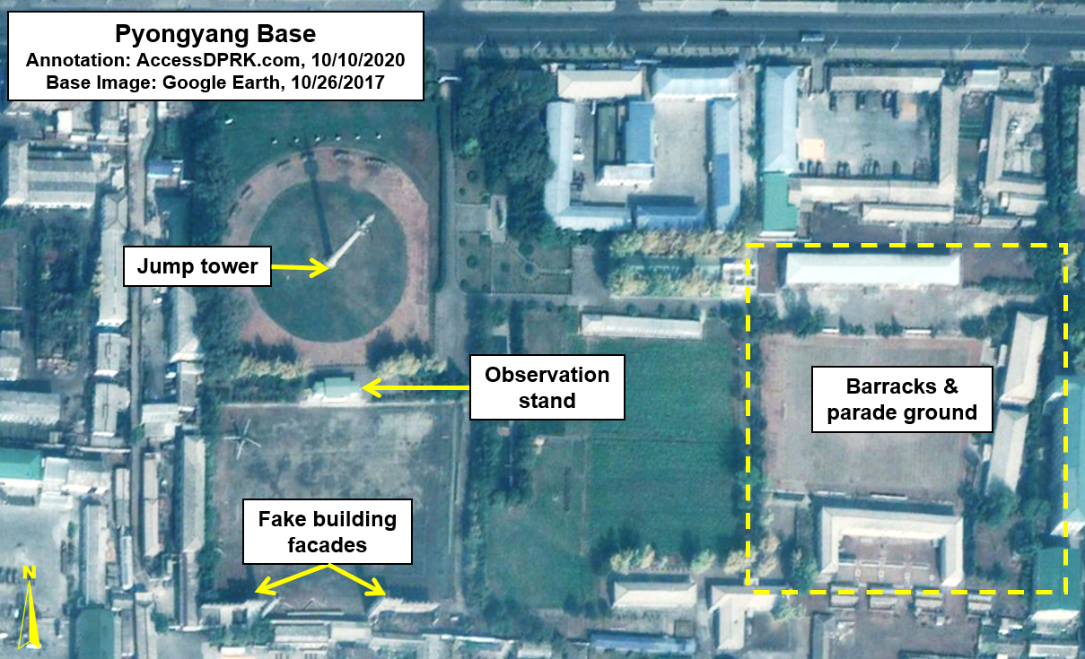
The site in Pyongyang is unique because it is located in an urban area. Two km away from the former Mirim Airfield and 6 km away from Kim Il Sung Square, the tower is located within a small training facility that occupies only 11.8 hectares. 

Unfortunately, I know very little about this base. Is it for training special forces? Is it part of the capital's defense corps? Perhaps it is used to train members of the Supreme Guard Command, the 200,000-man strong bodyguard force that protects the Kim family? I just don't know.

Very little has changed at the base since 2000 (the earliest available image on Google Earth) but it has been well maintained, suggesting that it has been in continual use. 


Sangwon (38.903° 125.967°)


Sangwon, in a small town within the larger Pyongyang region, is predominantly for jump training, although there are some smaller components to the base. Being within Pyongyang, it is surrounded by numerous other military bases including three other training facilities within 2.5 km of the airborne facility.

It is likely that Sangwon falls under the Army, and potentially the 38th Air Landing Brigade which is based in Pyongyang. Pyongyang is defended by a complex network of forces. The Supreme Guard Command, while tasked with keeping the Kim family and palaces safe, also coordinates with the Pyongyang Defense Command, III Corps, the Pyongyang Air Defense Command (as part of the Air Force), and the various internal police agencies. In all, this provides up to 350,000 soldiers and police stationed in and around the capital (many of the Supreme Guard's 200,000 men are not within Pyongyang, perhaps half are stationed across the country at various palaces).

Sangwon covers approximately 1.98 sq. km. The tower is concrete, and the facility has not undergone any substantial upgrades since at least 2006.

An interesting note is that Sangwon is less than 5 km away from a replica of the Blue House (South Korea's presidential residence) which was constructed in 2016, and was the site of a training exercise involving both paratroopers and other special operations forces storming the mock residence.  


Sonchon (39.823° 124.918°)


Sonchon was constructed sometime between 2014 and 2017 (there's a gap in images for the intervening years) and is a traditional steel lattice tower, but unlike most of the others, it only has two drop arms instead of three. If it is part of the Air Force, it would likely be under the 1st Air Combat Command headquartered at Kaechon. In the event it is Army, it would be controlled by VIII Corps. 

As mentioned earlier, this site was first brought to the public's attention (as far as I am aware) by Nathan Hunt in July 2020. One reason for why it may have gone largely unnoticed is that it is neither part of a major training base nor is it close to a major airbase (the closet being Panghyon in Kusong, 26 km to the northeast). However, it is also 20 km from Kwaksan AB. Kwaksan is a secondary air base, but it does have a wing of between 50-60 An-2s stationed there.

Although the training base is small and fairly nondescript at first glance, it happens to contain an underground facility (UGF), which makes the addition of a jump tower curious as they are seemingly unrelated structures.

The Sonchon underground facility doesn't appear to be part of manufacturing, so it's likely storage. Over the years some minor changes have been made to the site but this image from 2010 most clearly shows the berms and entrances.


Taetan (38.159° 125.222°)


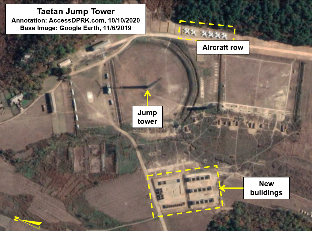
Named after the Taetan Airbase (aka T'aet'an-pihaengjang Airbase) that is just 3.3 km away across a range of hills, Taetan is one of the older training bases that has undergone recent upgrades.

In 2015 the steel tower was clad in either steel sheeting or wood to cover up the lattice structure, and in 2019 a row of six jets was added (likely non-functional planes to aid in training and getting recruits familiar with the equipment). Additionally, several buildings were being constructed across the parade ground.

The base covers approximately 3.5 sq. km and is divided into the airborne training section and the administrative/barracks section to the right of the airborne side.

The semi-circular area around the tower is 110 meters in diameter. From the tower to the small "landing zones" where recruits drop is roughly 15 meters (the drop arms also extend 15 meters from the main tower structure).

Taetan may be closest to the Taetan AB but it is also the only jump tower in South Hwanghae Province which is under the KPA IV Corps and the KPA Air Force 3rd Air Combat Command. These top-level commands oversee the whole province (and other areas). Within the province are six additional airfields, some host fighter jets and others are only for smaller craft like the An-2. Any necessary training for personnel at the other airfields would likely be sent to Taetan.


Taechon (39.864° 125.498°)


Taechon's steel lattice tower is a mere 4 km south of the Taechon Airbase which serves as the headquarters for the 5th Air Transport Division. It's a very small base but in 2018-2019, over two dozen buildings were constructed. It is also only 2.3 km away from a large military complex that has its own conventional training course.

At the larger base, historic imagery reveals various aircraft and helicopters, as well as tanks and other equipment. This suggests that the complex has both training/educational purposes and a maintenance role. There are also two underground sites within the complex. 

Given the airborne training base's proximity and the larger base's involvement with aircraft, it's hard to ignore the likelihood of the two places being connected.


Unsal (40.009° 125.879°)


The concrete jump tower was built sometime between 2012 and 2014 next to the largest urban warfare training center in North Korea. The whole base covers approximately 2.75 sq. km and there are other military sites nearby.

As we see again, there is an airborne site and urban warfare site being placed together. In all, four airborne training bases have obvious MOUT training facilities as well.

The purpose of the North Korean parachutist is to infiltrate and conduct operations behind the lines. They "pertain to creating total havoc deep inside South Korean territory. This includes attacking key infrastructure and military installations, and generally sowing massive terror among the already frightened South Korean populace," making their positioning within MOUT facilities a logical step.


The addition of the jump tower ca. 2014 isn't the only thing that has changed at Unsal. Around the same time, a small addition to the training grounds was added, and between 2017 and 2019 the administrative area of the base was modernized and several of the MOUT structures were demolished and replaced with apparent barracks.


Unsan (39.365° 126.052°)


As with the Taetan tower, the one in Unsan also had its lattice partially clad in either wood or steel in 2015. The landing area around the tower has a diameter of about 70 meters.

It is surrounded by numerous other training areas including shooting ranges, an equipment familiarization site (labeled "aircraft row" in the image), and it is located in between two larger military facilities. Given that all of the sites are directly connect via road (and without any security gates between them), I think it is actually one single large base approximately 4 sq. km in size.

Unsan is 14 km away from the important Sunchon and Pukchang airbases. It is also very close to an unusual defense complex. The complex has a variety of buildings with different purposes as well as equipment bunkers, possible educational buildings, and its own training grounds. 

I have asked several people about the complex and no one has been able to offer a definitive identification. However, most suspect that it is either a military academy or a research and development facility. The complex and airborne training center are also connected via road.


Conclusion

The sheer number of these facilities, their association with special forces facilities, and the fact that the regime has been willing to spend new resources on their capabilities and capacities means that North Korea's airborne troops and special operations forces will continue to pose a threat to the peninsula, and will be high on the list of forces to counter during any war.

Just because their facilities and equipment seem antiquated, doesn't mean they are without teeth. Wooden biplanes can fly low, evade most radars and surface-to-air missile systems in the region, and deploy highly motivated and trained troops to any point in South Korea. The An-2 fleet doesn't require major airfields, and in fact, can take off from any compacted dirt surface that has a straight run of 487 meters, turning plenty of highways into makeshift runways. (For comparison, fighter jets can require 2,500 meters or more of runway length.)

North Korea has a history of using their special forces in all four domains (land, air, sea, and cyber) to conduct operations against South Korea including assassination attempts and sinking ROK vessels.
Having robust airborne and special operations forces will enable the North to inflict significant damage during the opening stages of a war and enable them to continually harass the military and people of South Korea even in times of "peace".

North Korea has never been one to hide their true intentions. Be it with ballistic missiles, nuclear warheads, new submarines, or matters with their conventional forces, the country always broadcasts what their goals are.

In previous military parades, questions were raised about how "real" various weapon systems were to "just how the hell did they acquire them?" Were they real missiles or just bits of metal welded together to make for a good show? Did they build them domestically or do some creative engineering of foreign equipment?

Even with the most recent parade, questions surround the massive new ICBM and its transporter vehicle. Other questions were asked about the new battle tank displayed.

But each time questions are raised, the world ends up seeing fully functional systems within a year or two, not simply parade models. We see activities happening at the Sinpo submarine yard almost monthly, and after nearly a year of waiting, we received our first look at North Korea's new "strategic weapon" (now being called the Hwasong-16 ICBM).

The same must be said for the country's conventional forces. They broadcast what they're doing.

We should keep in mind that these additions to the country's arsenal have all happened in less than a decade under Kim Jong Un, and that 40% of the airborne training sites established throughout the country were done under Kim Jong Un. Many other military changes and developments have occurred, and others are being developed as I write this.

With these additions, the regime is talking. Are we listening?


I would like to thank my current Patreon supporters: Amanda O., Anders O., GreatPoppo, John Pike, Kbechs87, Planefag, and Russ Johnson.

--Jacob Bogle, 10/15/2020


Sunday, September 27, 2020

Open-Air Theaters Spread Across the Country

A hallmark of Kim Jong Un's rule has been the creation of entertainment centers. Be they amusement parks, ski resorts, children's traffic parks, and even "4D" theaters, new recreational facilities have popped up all over the country.

Packed house during the reopening of the Pyongyang Youth Open-air Theater. The theater was first built in 1959. KCNA Jan. 17, 2020.

Included in that mix are open-air theaters. Coinciding with the renovation of the Pyongyang Youth Open-air Theater, new theaters are under construction in nearly every provincial capital and some select other cities. In Chongjin, Haeju, Kanggye, Nampo, Pyongson, Rason, Sariwon, and Sinuiju, construction is well under way or nearly completed. Hamhung's theater is in the very initial stage of construction, and Wonsan already has an established open-air theater. 

The construction of most sites began in 2018 but has yet to be fully finished at any of them except for the refurbished Pyongyang theater.

Plays and film have always loomed large in North Korean culture with nearly every town having a traditional movie theater built/rebuilt almost immediately after the Korean War. Kim Jong Il, especially, loved movies, plays, and opera. He wrote numerous letters and books on the subject, including On the Art of Cinema and On the Art of Opera. Each explaining in detail his views on the subjects and how they can best serve the state's goals through "socialist art" and as tools of indoctrinating the people with correct forms of thought.

And while everyone in the country knows they're being propagandized to, a lifetime of exposure has taught them to tune out the obvious stuff and enjoy the stories themselves. Indeed, North Korean's are quite the vocal art critics - in their subtle ways to avoid accidentally criticizing the regime. A good film, play, or song will rapidly make its way through the cities and into the countryside.

Soon after Kim Jong Un came to power, in recognition of the people's love of film, "4D-rythmic" theaters began to be built and now there's one in most large cities. With their distinctive architecture, they're easy to spot.

Built in 2014-2015, the 4D theater now sits just 100 meters away from the new open-air theater. These facilities are on the grounds of the former Nampo Sports Village. Built in 1973, only the stadium and regatta course were ever completed.

Participation in "mass-based art" has long been promoted with, "All provinces, cities, counties, industrial establishments and cooperative farms across the country have halls of culture, libraries and reading halls. Theatres and halls of culture in different parts of the country are equipped with facilities and musical instruments necessary for cultural and emotional life and artistic activities of working people." - Naenara, July 20, 2020

There is some variation in size with each of the new open-air theaters, ranging from 65-80 meters front-to-back and 85-100 meters at the widest. The existing Pyongyang theater is approximately twice the size as the newly built ones.

Sinuiju theater still under construction as of Nov. 27, 2019.

In the case of Sinuiju, there are 38 rows of seating arranged on three levels and into 13 sections. The Pyongyang Youth Open-Air Theater has seating for 10,000 and the theater in Haeju is said to have a seating capacity of 5,000. Given that Haeju is closer in size to the others, all of the new theaters probably have a seating capacity ranging from 5,000 to 7,000.

These theaters are also used for things other than plays and performances. Films can be shown, lectures given, and educational classes are provided. This not only makes them an important part of North Korean culture but they also provide the state with another venue for instilling propaganda and disseminating the wishes of the Korean Workers' Party. 

Primary construction of the Rason Open-Air Theater only began this year. As of July, there was still a lot of work left to do. While most theaters are located amongst the rest of the town, Rason's is positioned 200 feet above on a hillside overlooking the bay. No doubt the views will be great once it's finished.

The Pyongyang theater had a set of solar panels added to its roof. It is likely that the other new theaters will also include solar power. This fits in with the country's incremental adoption of green energy solutions to their otherwise extreme electricity shortage. 

Provincial capitals usually have a handful of distinctive features (like joint murals of Kim Il Sung and Kim Jong Il) that other cities tend to lack. However, certain things eventually make their way into other important cities after their popularity has been assessed in the capitals. I wouldn't be surprised if these open-air theaters end up spreading to a few more cities in the coming years.


I would like to thank my current Patreon supporters: Amanda O., Andres O. GreatPoppo, John Pike, Kbechs87, Planefag, and Russ Johnson.

--Jacob Bogle, 9/26/2020
AccessDPRK.com
JacobBogle.com
Facebook.com/accessdprk
Twitter.com/JacobBogle

Wednesday, September 16, 2020

Markets Still Grow Despite Economic Headwinds

Researching North Korea's economic development is always fraught with difficulties. The state offers very little in the way of concrete data, and state media predominantly focuses on single items (like a factory or amusement park being built) and gives exaggerated reports on national trends. At least, until Kim Jong Un came to power. 

While the amount of reliable information is still sparse, Kim Jong Un has broken with tradition and hasn't been afraid to speak openly about the difficulties facing the country. He has even blamed the bureaucracy itself on occasion instead of always chalking up problems to sinister western forces or on a single bad administrator.

Pyongyang Central District Market. Yonhap, 2006.

It is clear that the people's lives have improved since the days of Kim Jong Il but to what extent that trend has carried on into the last few years is murky and appears to be fairly uneven. How much the civilian and military economies have undergone structural changes under Kim Jong Un is likewise murky. However, all one has to do is pull up Google Earth to see billions worth of construction activity over the years, and to examine their missile tests to tell that Kim has certainly surpassed his father in the military sphere. 

Now, before you start accusing me of calling Kim Jong Un a reformer, I'm not. But it is irrefutable that his governing style - while still autocratic - is somewhat different from that of his father's. Many of the obstacles and opportunities facing this generation are also fairly different than the ones facing the famine generation, so, naturally, the economic dynamics are going to change.


Markets for things like handicrafts have always been allowed in North Korea, but markets for selling grain, consumer goods, etc. were forbidden. That all changed during the course of the famine when farmers' markets popped up along roadsides across the country as people picked survival over obeisance to the state. In turn, the government has sought to regulate them (thus giving tacit approval to their operation), and according to the Center for Strategic and International Studies (CSIS), the state earns between $60 and $70 million annually from fees and taxes imposed on the markets as of 2018. Over the past decade or so the number of approved markets has roughly doubled, and as of this year, I have been able to identify 443 of them. 


This implies a fairly robust civilian economy, even if it is faced with numerous obstacles (particularly in 2020 as the result of COVID-19 and after multiple typhoon impacts). Specifically, the service sector, retail, and construction have all been growing drivers of the economy for at least a generation.

How much of this can be attributed to the fact Kim was left an "inheritance", reportedly worth up to $5 billion, that he was able to invest in weapons and economic construction, how much is due to illicit trading activities, and how much may be due to a civilian economy that has become even more market-oriented despite the regime's protestations can't fully be known. Regardless, the results are the same.

To demonstrate that the civilian economy is still growing despite internal and external economic pressures (including sanctions), I want to show some changes that can be seen in 23 markets across the country. (A list of these markets can be found at the end of the article.)

These changes have all taken place from 2015 to 2019 and includes markets in major cities and in more rural areas. The changes are: the building of entirely new markets and the expansions of existing ones.

Since 2015, at least thirteen new markets have been constructed with a combined area of approximately 47,271 square meters (508,820 sq. feet) of new selling space. The largest of the new markets was constructed in Chollima (Kangson) in 2019 and ranks among the largest markets in the country, covering 15,920 sq. m (171,361 sq. ft.).

Google Earth image showing the recently constructed market. An overflow crowd is also visible.

Additionally, since 2015 at least eight other markets have undergone relatively substantial expansions, and two more were converted from open-air markets to being housed in buildings. Between the expansions and added covered floor space, the total additional area equals 18,906 sq. m (203,502 sq. ft.).

The result of these changes is that there has been an increase of 66,177 sq. m (712,323 sq. ft.) worth of market space in just four years.

According to CSIS, the largest market in the country generates the equivalent of $36/sq. m in revenue to the government each year. If we make a simple assumption that these new spaces will generate only $15 per square meter, that still represents nearly an extra $1 million a year going to Kim Jong Un's coffers (solely from fees and taxes at the markets). The regime generates additional revenue through the process of transporting goods, trading permit fees, paying bribes to border guards and officials, etc. 

The fact new markets were also built after 2017, when economic sanctions against North Korea reached their height, tells us that the country's domestic economy and illicit trade is likely more robust than is generally thought. 

This is backed up by Panel of Expert reporting by the United Nations that claims the country could be illegally importing three to eight times the amount of petroleum products it is legally allowed. That also helps explain how the regime has been able to build scores of gas stations in recent years which are estimated to consume the equivalent of the country's entire legal fuel import amount. Other illicit trading involves coal, seafood, and even sand exports.

And while COVID-19 has placed a tremendous strain on the economy, North Korea is still managing to build the largest hydroelectric project in its history, construction of the Pyongyang General Hospital is nearing completion, and the capital has embarked on a housing building boom.

Additional projects like multiple small hydroelectric dams, large collective farms (such as the Jangchong Vegetable Farm), and various construction projects that can be found in most medium and large-sized towns, all point to a country that is not stationary. 

Clearly, the misallocation of resources on things like nuclear weapons and future missile tests places a burden on economic growth. And the extremely poor state of the country's electrical grid, transportation system, and healthcare network means the country is in many ways still trying to fully recover from the downfall of the 1990s, but economic progress can nonetheless be seen.


I would like to thank my current Patreon supporters: Amanda O., Anders O., GreatPoppo, Kbechs87, John Pike, Planefag, Russ Johnson, and Travis Murdock.

--Jacob Bogle, 9/14/2020
AccessDPRK.com
JacobBogle.com
Facebook.com/accessdprk
Twitter.com/JacobBogle


Notes
The 13 newly constructed markets are located in: Chollima (38.931° 125.561°); Jonchon (40.616° 126.459°); Kag'am-dong (39.565° 125.851°); Kangdong-Pangwha (39.161° 126.023°); Kimchaek (40.674° 129.181°); Kumya (39.540° 127.246°); Samjigang (38.412° 125.691°); Nampo A (38.753° 125.396°); Nampo B (38.735° 125.418°); Pyongsan A (38.335° 126.393°); Pyongsan B (38.327° 126.412°); Riwon (40.319° 128.663°); Sariwon (38.509° 125.767°)

The 10 expanded markets are located in: Chollima (38.928° 125.560°); Chongjin (41.790° 129.767°); Chongju (39.696° 125.219°); Hamju (39.855° 127.435°); Kangdong (39.138° 126.094°); Koksan (38.782° 126.669°); Sin'gye (38.500° 126.524°); Songang (37.887° 125.154°); Wolthan (41.413° 127.057°); Wonsan (39.175° 127.378°)

Friday, August 21, 2020

Renovations at Elite Hot Springs Appear on Hold Due to Economic Pressures

 
While Kim Jong Un was busy issuing orders to reconstruct the city of Samjiyon, to build kilometers of beachfront resorts in Wonsan, and constructing a new hot springs facility in Yangdok, he wasn’t going to neglect Onpho in the process.

Nestled in a valley a few kilometers northwest of the city of Kyongsong in North Hamgyong Province, the Onpho Holiday Camp, a hot springs resort, has been popular among the country’s elite for decades.

The original facilities at the Onpho hot springs resort as seen on Sept. 29, 2017. 
 
It is one of the oldest and largest such facilities in the country and has been visited by each generation of the Kim family. It is so popular to the elites that a secured villa complex was built next to the general spa area and a special “leadership train station” was added around 2010 to allow for speedy and secure transportation to the relaxing hot springs and mountain air that flows down into the valley.

However, during Kim Jong Un’s visit to Onpho in July 2018, he lamentedits very bad condition, saying bathtubs for hot spring therapy are dirty, gloomy and unsanitary for their poor management.”
By October, Google Earth images revealed that the resort was being renovated as temporary worker’s housing was visible as well as the land being cleared for new buildings.

Initial work activity at the resort in October 2018, with various temporary structure like worker’s huts and workshops visible.
 
After that initial activity, construction slowed down and little had been accomplished five months later in March 2019. That lull quickly changed as by September, at least fourteen buildings were under construction in the main resort area and a dozen multifamily housing structures were also being constructed across the river for employees of the spa.

During Kim Jong Un’s 2018 visit he mentioned that the bad condition of Onpho would “commit a sin” by drawing criticism from the people in a place that was so important to Kim Il Sung and Kim Jong Il. Testifying to Onpho’s importance, it has an entire park and monument dedicated to the “exploits of the great leaders” with regard to the establishment of the resort.

The historic importance of the resort was commented on by the Korean Central News Agency back in 2015 when they stated that Kim Il Sung had visited the natural hot springs at Onpho as early as 1946 and ordered it be turned into a holiday camp. He then visited and gave “field guidance” a further twenty times, followed by visits by Kim Jong Il including one trip in 2008 after the area had been hit by flooding.

Kim Jong Un has made it a key feature of his rule to (attempt to) improve international and domestic tourism by spending hundreds of millions of dollars – perhaps a billion or more in total – constructing numerous tourism related facilities across the country including a $35 million ski resort, converting the Wonsan-Kalma area into a major tourist region (which included an estimated $200 million reconstruction of the Kalma International Airport), and more recently, discussing the need to modernize the Mt. Kumgang Tourist Zone that was opened as a joint project with South Korea back in 1998.

All of this, of course, despite the fact that North Korea doesn’t have hordes of foreign visitors to fill up those thousands of hotel rooms now available nor does it have a strong enough domestic economy to sustain all of the resorts with predominately local tourists.

However, the fact that Onpho plays a role in the Kim family personality cult and that it has been a longstanding feature the state could point to as evidence of Kim Il Sung’s love for the people, it makes sense that Kim Jong Un would want to renovate such a place that had become dilapidated.

Unfortunately for the regime, economic pressures don’t care about prestige projects and there has been very little new construction during all of 2020 as late as July.

The combination of existing economic problems and the added pressures relating to the COVID-19 pandemic have caused considerable difficulties for the country. As a reflection of this, it was reported by DailyNK on April 23 that the regime sent out a jointly signed document by the Cabinet and Central Committee of the Korean Worker’s Party decreasing the number of “national construction projects” from fifteen to just five.

While the report didn’t say what those fifteen projects were, two of the remaining ones are undoubtedly the Pyongyang General Hospital and the Tanchon Hydroelectric Project. Both have experienced funding and material shortages, with Kim Jong Un lashing out at officials over mismanagement regarding the hospital’s construction.

Onpho may be an ideologically important site but it isn’t fundamental to the country’s health or electricity needs, so the lack of construction this year may well be a reflection of economic problems and the April “joint decision document” cutting back on less practical projects.

The one area inside the large resort complex that hasn’t seen any renovation, somewhat conspicuously, is the leadership villa compound adjacent to the main spa facilities. This walled compound contains a primary palace building and six smaller villas.

The villa compound at Onpho.
 
After Kim Jong Un came to power, he wasted no time making improvements to a number of leadership residences including the addition of runways (such as at Hyesan and Changsong), he completely rebuilt villas within the “Forbidden City” district in central Pyongyang, and he undertook multiple changes to the Kim family primary Ryongsong Residence complex.

Nonetheless, what can be seen from commercial imagery does show substantial changes occurring at the holiday camp area. In addition to the hotel buildings (each around seven-stories tall) and new personnel housing, three unidentified but large buildings are also under construction. Located on the banks of the river, the three buildings have a combined footprint of approximately 6,814 square meters and are each multistory buildings.

Google Earth image showing the status of renovations on October 25, 2019.
 
Image dated July 2, 2020 showing only limited construction progress since 2019 except for the apparent completion of the new monument and museum park.
 
Additionally, a new monument area has been constructed that, as of the most recent Google Earth imagery, has two monuments and two buildings that are likely “revolutionary history museums” dedicated to Kim Il Sung and Kim Jong Il. Such monuments and museums are common to ideologically important places and places that have received multiple visits by the leadership. And in true North Korea fashion, this portion seems to be the first new part of Onpho to have been completed; the final landscaping touches being visible by July 2, 2020.

Construction may have been stalled due to unforeseen events, but the addition of Onpho to the long list of recreational facilities that Kim Jong Un has either built or modernized shows that “bread and circuses” are still a central tenet of his regime. From diplomatic maneuvers to testing missiles, to spas and rebuilt towns, every dictator needs a well-rounded legacy to go along with the less-than-voluntary labor it often takes to build these places.


I would like to thank my current Patreon supporters: Amanda O., Anders O., GreatPoppo, Kbechs87, Planefag, Russ Johnson, and Travis Murdock.

Thursday, August 13, 2020

History of the Musan Iron Mine

The Musan Iron Mine sits atop one of the largest iron deposits in northeast Asia and has been an integral part of North Korea's industrial base since the country's inception. Exact estimates vary but the open-pit mining complex holds at least 1.5 billion tons of economically viable ore (with total reserves estimated at around 7 billion tons). As such, interest in Musan goes back generations, with the first industrial-scale mining beginning in 1935 during the Japanese occupation. 
Post-famine problems meeting production capacity have had ripple effects across North Korea's economy and its ability to carry out major construction projects.  

Operations at Musan mine. Image source: Wikimapia.

The mine has rarely operated at full capacity but did run relatively smoothly during the first few decades of North Korea's existence. Since the economic collapse of the 1990s and the country's subsequent inability to ensure constant electricity supplies and maintain or replace needed industrial equipment, operating capacity has bounced around from 60% to as low as 30%. 

Pyongyang's COVID-19 mitigation measures have complicated the mine's operations and further limited income from iron ore trading. The long-term effects of these measures on both the mine and the economy as a whole have yet to be fully realized, but until North Korea can improve the mine's output or shift operations to another, more productive mine, the country will be seriously stunted in its ability to continue to engage in large-scale construction projects simultaneously like the Pyongyang General Hospital and Tanchon Hydroelectric Project.

Early history

As noted earlier, industrial mining operations began in 1935 by the Japanese company Mitsubishi Mining Co. The initial operating capacity for processing the ore concentrate was planned to be 500,000 metric tonnes annually. In 1942 that was increased to 1 million tonnes and an even larger plant was under construction in 1945.

From 1940-45, the mine was able to produce 3,838,454 tonnes of ore concentrate at an average iron concentration of 58% elemental iron. Obviously, Japan's loss in World War II and the subsequent division of the Korean Peninsula interrupted mine operations. 

This 1952 geologic map shows the area of iron deposits (darkest regions). From "Mineral Trade Notes", US Bureau of Mines, 1952.

The area of heaviest deposits in this 1952 map covers approx. 247 square hectares (0.97 sq. miles). 

Musan under Kim Il Sung

Nationwide, the mining sector in northern Korea underwent a drastic decline from the end of WWII through to reconstruction after the Korean War. The new North Korea that emerged afterward placed modest goals for mining in their first economic plans. Musan was expected to produce 400,000 tons only by 1956, less than the realized average of 639,000 tons annually from 1940-45.

Under Japan, northern Korea had largely been seen as a source of raw materials. Kim Il Sung sought to address that "colonial lopsidedness" by emphasizing machine productions. After years of interruptions, war, and flooded mines, the need to get Musan (and the whole mining sector) back up was never more important if Kim Il Sung was to realize his goal of turning North Korea into a powerful industrialized country. 

To fulfill plans to produce 6.1 billion won (~$5.08 billion[1]) worth of machinery in 1956, the state would need every kilogram of iron it could find.

The 1960s was a period of substantial economic growth, albeit, not without its problems. Nationally, 1960 saw the production of 3.11 million metric tons of iron ore and steel. That grew to 4 million tonnes in 1964. 
Steel production grew at 13% a year and for the 1971-76 Six-Year Plan, the regime wanted to increase output to 3.8 million tons annually. During this period, Musan was providing at least two-thirds of all iron mined in the country.

The bulk of the ore was sent to steel mills at Chongjin and Kimchaek. At the same time that mining and milling operations were growing, trade in iron and steel was also growing. Throughout the 1960s trade increased from $34 million in 1961 to $56 million in 1969, with 400,000 tons of ore shipped to China in 1966 alone.

By the end of the 1971-76 economic plan, prospects for continued growth in mining and steel milling looked good, although the industry was heavily reliant on Soviet help for technical and mechanical assistance and on China for raw materials involved in ore processing and steel production.


Later Operations

Throughout the 1970s and into the 1980s, national iron production continued to grow until its peak in 1985 at 9.8 million tonnes. From there, it declined precipitously reaching a low of 2.9 million tonnes in 1997. This decline coincides with the faltering trade between Soviet Bloc countries and North Korea (largely caused by Soviet attempts at reform and demanding repayments of debt), the eventual collapse of the Soviet Union, and finally, the famine that began in 1994. 

Environmental factors also played a role as floods damaged mines across the country and severely limited their ability to extract minerals. Many mines were completely shut down and those that kept functioning operating at severely decreased capacities, not least because the workforce struggled to keep working in the face of starvation.

Musan Iron Mine as seen from Landsat in 1984.


Musan Iron Mine as seen via Google Earth in 2019.

After reviewing the available information specific to Musan, I don't think the mine has ever recovered its full operating capacity since the 1990s nor has it been able to sustain long-term growth in production. The reasons for this are manifold: electricity supply problems, lack of modern mining equipment (most machines are 40-50 years old and older), the state's insistence on cutting corners regarding safety that leads to delays with each accident, and obviously, ever-tightening international sanctions regimes play a role. 

However, as the two above images show, the mine has very visibly grown between 1984 and 2019 and had tripled in size between 1970 and 2007. The large difference in size from 1952 to the present likely reflects attempts to recover lower quality ore that lies outside of the primary deposit as well as improved geophysical surveys revealing more iron deposits throughout the area.

As noted before, the production rate of Musan fluctuates wildly, with the mine only operating at 30% in 2006. To boost production, North Korea has looked to joint ventures with a number of foreign companies. The largest deal was inked in 2005. The agreement with a consortium including the Chinese Tonghua Iron & Steel (Group) Co. Ltd. would have provided $867 million for a 50-year exploration rights deal. 
The goal of the plan was to increase iron production from less than 3 million tonnes in 2004 to 10 million tonnes in 2010. However, the plan was abruptly canceled in 2009 by North Korea.

Other endeavors to increase investment in the mining and steel industries (which have a mixed track record of success) include negotiations with Global Steel Holdings, Sinosteel Corporation, and a deal with Shougang Tonggang Group managed to yield a $2.2 million investment in a small steel factory.

The overall results of these deals on North Korea's mining industry and on Musan, in particular, have been hard to quantify and various reports coming out of the country tell a story of continual shortages.

More recently, the addition of UN sanctions in 2016 and 2017 (UNSCR 2270 & 2371) prohibited the importation of machinery and the export of minerals like iron. When taken in combination with other sanctions (from the UN, EU, and United States) nearly all forms of legal financial investment in the country have been cut off.

Levels of illicit trade from Musan managed to continue until North Korea closed its borders due to COVID-19, when all forms of trade fell dramatically. However, that trade hasn't been enough to offset either the sanctions or the chronic electricity and infrastructure problems the country has yet to overcome. 

Throughout the problems facing the mine and its workers, the miners continue to push on with their work. While it is primarily mining blocks No. 1 and No. 3 (out of seven blocks) that are kept operational at any given time, there is evidence that the regime is trying to expand those primary blocks and to open new sites along the mountain range in which Musan sits. New mining sites have either been opened or are currently being explored at three different locations along an 8 km line extending north of the main mine.

One such operation occurred in January 2018, when 450,000 cubic meters (approx. 1 million tonnes) of overburden was blasted away to expose more ore. 


Lastly, while Musan lurches between higher levels of activity and near shutdowns, one thing that has remained constant is pollution from the mining, processing, and storage of the ore as well as from the general operational requirements of such a large mine. 

River pollution from North Korea's mining, manufacturing, and electricity sectors has been a longstanding problem, and the Musan Iron Mine has been recognized as a major contributor of pollution along the Tumen watershed.

The water treatment systems along the 8.5 km stretch of the Songchon River that flows by the mine are largely inoperative. This river empties into the Tumen River (which serves as the Sino-DPRK border) and is a source of drinking water for both Musan and all of the Chinese and North Korean towns downriver. Lack of adequate pollution control has caused "significant environmental damage". 


Notes:
1. This is only an approximation based on a nominal rate of $1 USD to 1.2 KPW won between 1961-1974. Source: http://oldsite.nautilus.org/DPRKBriefingBook/economy/DPRKMonetaryHistory.html


I would like to thank my current Patreon supporters: Amanda O., Anders O., GreatPoppo, Kbechs87, Planefag, Russ Johnson, and Travis Murdock.

Friday, July 24, 2020

Wollo-ri: Much Ado About Something

A counter-analysis examining known nuclear facilities and important civilian facilities reveals there are still many questions surrounding the site at Wollo-ri (also spelled Wonro-ri), and that a conclusion as to its purpose cannot yet be ascertained based on publicly available information.

Note: to save this report and read it later, you can download the PDF version here.

On July 8, 2020, CNN reported on research done by experts from the Middlebury Institute of International Studies on a facility in the village of Wollo-ri (near Pyongyang) that claims the facility is part of North Korea’s nuclear program and is likely involved in either warhead production or warhead storage.

Jeffrey Lewis and fellow researchers Catherine Dill, David LaBoon, and Dave Schmerler then published a more detailed account of their line of reasoning on the Arms Control Wonk blog. The post listed a number of visual signatures about Wollo-ri that led them to suspect the facility was part of the country’s nuclear program. That suspicion was then bolstered by a mention in Ankit Panda’s new book Kim Jong Un and the Bomb, in which Panda says that the US intelligence community assesses that there is an undeclared nuclear facility in Wollo-ri. Having that public mention of the facility led to Lewis et. al going public with their own research.

After the reporting, a number of experts commentedA and gave the general view that there is nothing specific to Wollo-ri that would make it a suspected nuclear facility. I happen to agree. However, there hasn’t been a point-by-point counter-analysis of why some experts may disagree with the assessment by Lewis et. al. That is the purpose of this report.

Before I go on, I want to be clear that none of this should be construed to mean that Wollo-ri isn’t a nuclear facility. It might be and it might not be. What I am attempting to show is that while the possibility exists, the probability of it is low based on the available evidence (especially whether it’s a storage facility), and that more research needs to be done before coming to any conclusion.


In the Arms Control Wonk post, five points are listed to support the group’s conclusion that this facility is likely an undeclared nuclear site. I would like to go through each of those points and give my reasoning for why I don’t think they are necessarily, either individually or collectively, direct signatures of a nuclear facility.

The signature elements described are:

1. A strong security perimeter

2. On-site housing

3. Monuments commemorating unpublicized leadership visits

4. The existence of underground facilities (UGFs)

5. Lewis also uses a description by US officials in September 2018 that talk about an undeclared warhead storage facility. The unnamed officials are cited as saying North Korea “built structures to obscure the entrance to at least one warhead storage facility” and that “the U.S. has also observed North Korean workers moving warheads out of the facility.”


On the security perimeter

The facility is surrounded by a wall that runs along the full perimeter of the site and is approximately 1,460 meters long. Lewis points out the fact that the nearby Ryongaksan Spring Water Factory doesn’t have any such perimeter wall, and so the wall’s existence helps to key us onto the fact that the facility is important.

Typically, this is true. Most civilian facilities lack a defined perimeter. However, many military sites lack them as well. In fact, few military sites have more than a guard post at the entrance let alone full perimeter security. There is even an artillery base located a mere 60 meters from Wollo-ri’s perimeter that doesn’t appear to be surrounded by anything; no wall, no fence, nothing. 

And while most civilian sites lack a wall, some do have one. An example is the nearby Mangyongdae Chicken Farm (39° 2'47.29"N 125°38'44.50"E) which has its own 2.9-kilometer-long wall.

When examining known nuclear-related facilities, we do find that most have a perimeter wall. The Pyongsan uranium processing and milling plant has one, each of the laboratories and research compounds within Yongbyon have their own walls, and sites associated with their WMD/missile programs also have them like the Kim Jong Un National Defense University. But while looking at these places, a key difference between them and Wollo-ri becomes apparent. 

The Wollo-ri facility has three entrances into the complex. There is a primary entrance at the southwest corner and then two others along the eastern portion of the wall. Every other known and suspected nuclear facility only has one direct entrance, including the suspected uranium enrichment site at Kangson which Lewis described in 2018.

The entrances at Wollo-ri are also fairly basic and do not appear to include anything substantial blocking the entry points, just small guard huts. No gate or movable fencing to impede forced entry.

Having multiple entry/exit points raises the security risk that something could be stolen. And having multiple sets of guards raises the risk that someone could be bribed to let in an unauthorized person(s).

Facilities like Yongbyon and the Punggye-ri nuclear test site, where substantial nuclear components and functional nuclear devices are held, take a multilayered approach to security. To get to the actual testing tunnels at Punggye-ri, one has to travel along several kilometers of narrow road and make it through multiple checkpoints. If Wollo-ri is where nuclear warheads are either being produced or stored, only the strictest security measures make sense.

Of on-site housing

Image showing apartment buildings ("A") at both Kangson and Wollo-ri.

Using Kangson as an example, Lewis cites what are likely apartment blocks within the perimeter as evidence that the facility may be part of the country’s nuclear program because having on-site housing (within a walled complex) is quite rare, and Kangson also has on-site housing. On-site housing is indeed unusual in North Korea but most nuclear facilities, in fact, do not have such an arrangement. Neither the Pyongsan or Pakchon uranium milling plants have housing, Yongbyon is a closed city with a defined housing district but no housing within the individual research and production areas, and the Academy of National Defense Science (Sanum-dong) lacks it as well. Other sites may have housing but part of that is due to the expansive size or remoteness of the facilities in question.

To be short, on-site housing at any facility would indicate it has some level of importance, but it is not a unique identifier of nuclear facilities.

Another thing to consider is how the housing relates to Wollo-ri’s potential purpose.

Wollo-ri lacks any obvious substantial electrical infrastructure which would point to the existence of energy-intensive industrial activity or to a large underground facility. When the site at Kangson was constructed, an electrical substation was built nearby as well to help provide the needed electricity. Lacking its own substation or major transmission lines, this would suggest that whatever is going on at Wollo-ri wouldn’t be intense industrial activity or producing large numbers of parts.

At the same time, there are six apartment blocks at the facility. I estimate that there are as many as 406 apartment unitsB; each given to a worker and their family. Assuming some couples work together, let’s make it an even 450 employees.

North Korea’s nuclear inventory has less than 100 warheads and it is estimated that they can produce no more than twelve bombs per year at maximum output. The country already possess an industrial base known to produce a range of electrical components for their ballistic missiles and other weapon systems, and more dangerous components (like the explosive lenses) are manufactured elsewhere, so an undeclared production facility would likely be used in the production of specialty parts. But you wouldn’t necessarily need 450 employees to produce a handful of small devices each year.


The monuments

Monuments can be an indicator of the importance of a facility. Whether it educational, industrial, agricultural, or military, the type of monument(s) seen at a site can help give a fairly unambiguous ranking for the place. They can also indicate if Kim Jong Un (or his predecessors) has visited before.

Wollo-ri possesses two monuments: a Tower of Immortality and an apparent joint mural of Kim Il Sung and Kim Jong Il.

A typical example of a Tower of Immortality.

Towers are found in every town in the country and they are dedicated to the “eternal” lives of Kim Il Sung and Kim Jong Il. They can also be found at universities, factories, and other sites the regime deems worthy. During my 2019 survey of North Korean monuments, I found at least 5,175 Towers across the country.

Joint murals are found in county seats and at even more rarified civilian and military facilities.

In some places you can clearly see the faces of the Kims through satellite imagery. Unfortunately, the mural view at Wollo-ri isn’t the greatest quality. But what is obvious is that there are two images being shown (interpreted as busts of the Kims) and the rest of the monument’s surface appears to be white. This is indicative of a joint mural. Unlike the thousands of Towers, fewer than 300 were identified during the monument survey.

The existence of the mural at Wollo-ri is important, however, it isn’t a signature of a nuclear facility, even when combined with the Tower. The headquarters of North Korea’s air force has at least seven monuments and a joint statue of Kim Il Sung and Kim Jong Il, the highest honor any North Korean site can be bestowed. The headquarters also has a defined perimeter and on-site housing.

Monument at the Mangyongdae Children’s Camp commemorating visits by Kim Il Sung in 1974 and Kim Jong Un in 2016. | Screenshot provided by Colin Zwirko.

In the Arms Control Wonk post, it is claimed that the monuments at Wollo-ri indicate visits to the facility by the country’s leadership. That is simply incorrect. As I have described, Towers and joint murals are found in many locations and none are directly connected to leadership visits, rather, they are daily reminders of the Kim family cult and (when taken in combination) can ascribe a level of importance to a given site. Commemorative monuments are much smaller and are typically rectangular blocks of stone with a brief inscription carved into the surface.

These can be found at many (but not all) places visited by the Kims. In the event of multiple visits, instead of having an ever-growing wall of monuments, a museum will be built. This was the case with Korean People’s Army Farm No. 1116 which has received annual visits by Kim Jong Un since 2013. Even if visits to Wollo-ri weren’t publicized, the facility would still be awarded with a monument.

Wollo-ri only has the Tower and mural.


Underground facilities

In the most simplistic terms, an underground facility (UGF) could be defined as any useful structure with an inch of dirt placed on top. However, most wouldn’t consider a root cellar or simple basement a genuine underground facility. Particularly for the purpose of secure and clandestine manufacturing or storage, underground facilities are located multiple meters below the ground if they are placed underneath an existing building or they are excavated deep into hills and mountains.

North Korea probably has more identified underground sites than any country on earth. Some are enormous arms production facilities (like the Kanggye General Tractor Plant, the largest known underground arms manufacturing plant in North Korea) and others are smaller facilities used for storage or that sit empty until needed in the event of a conflict. They are all clearly identifiable once you know what to look for.

There are two hardened structures at Wollo-ri at the front end of the complex that were built in 2011-2012. (Coordinates: 39° 3'9.59"N 125°37'8.36"E) Neither is larger than 20 meters wide and there was no evidence of excavation work during their construction to suggest they cover an underground entrance. Small hardened structures like these are common enough and are often used to store fuel or for other benign purposes.

There is also a small trench-like structure that is barely two meters wide that lies in the northeast section. (Coordinates: 39° 3'19.82"N 125°37'15.41"E) It does not connect to any building and doesn’t match the design of any other underground entry point one can find throughout the country. If it is supposed to be part of a UGF, I would say construction is just in the initial stages.

Most underground facilities are easy to spot.

One such facility is between the cities of Pyongsong and Sunchon, beneath Mt. Sonje. It has four entry points and there are piles of debris that were excavated from inside the hill during construction. 

In other cases, where a building hides the entry point, the building is flush with the hillside. None of the main buildings at Wollo-ri are flush with the hillside. The other buildings at Wollo-ri could only hide a UGF that was constructed directly beneath them and there is no evidence of that having occurred. (Construction wasn’t caught on imagery and no large debris piles are evident.)

In the event where you connect a UGF to a building that isn’t flush with the surrounding landscape, a connecting structure is built. A prime example of that is a connecting tunnel that was built in 2017 and connects a building in the Armed Forces District of Pyongyang to a massive underground complex. It is approx. 6 meters wide and extends a maximum of 20 meters to reach the hill. Prior to this connecting structure, the main entrance, 660 meters away from the newer one, was still identifiable.


Warhead storage possibility

Lewis’ addition of the description of an unidentified nuclear warhead storage facility is interesting but there was nothing in the description that mentioned Wollo-ri or that gave a specific location. The officials simply said there’s a warhead storage site somewhere. In terms of storage, there are other more suitable places suspected of being warhead storage facilities, including one near the city of Kusong.

And when looking at known warhead storage sites around the world, a few trends become clear. Namely, very tight security and underground storage. The largest warhead repository in the world is the Kirtland Underground Munitions and Maintenance Storage Complex in the scrublands around Albuquerque. The underground portion alone covers roughly 57,000 square meters (not including the potential for multiple levels).

It has a single entry point, it is surrounded by fencing, and has three watchtowers. Plus, it is situated in the middle of a larger military complex.

Incirlick AB with US/NATO nuclear storage site highlighted. | Image source: Federation of American Scientists/Hans Kristensen

Turkey’s Incirlik Air Base is another place that houses American/NATO warheads (up to 50). They are stored underground in the center of the air base which is the most secure area.

The lack of any identifiable underground facilities at Wollo-ri, its questionable security, and the lack of any direct mention of the site specifically as a storage facility leads me to conclude that while it may have a role to play in North Korea’s nuclear program, the probability of it being a warhead storage facility is almost zero. Adding to that assessment are the additional facts that Wollo-ri is located far away from any long-range missile bases and the fact that it is located just a few miles of an elite section of Pyongyang.

In order for North Korea’s ballistic missiles to be a credible threat, they must be near the warheads. Wollo-ri is nearly 70 km away from the nearest known ballistic missile base and that journey would take hours across miles of winding road and rail – an easy target to destroy.

And while North Korea does have a habit of meshing military and civilian areas together, any direct hit to a nuclear storage site would spread radioactive material across a wide area thanks to fire and wind currents, contaminating the city with highly enriched uranium and/or plutonium (depending on the type of weapons stored there).


Political University?

I’d like to briefly discuss an alternative explanation put forth by an alleged North Korean official. He claimed that the facility is actually the “Pyongyang Anti-aircraft Unit Command’s Political Military University”. I and many others deeply question this explanation. There is a state security academy nearby at 39° 2'39.39"N 125°38'1.49"E, and it and all of the other known political and security schools follow a very specific pattern. Wollo-ri does not comport with that pattern and deviates from it in a number of ways. While I am not convinced that Wollo-ri is a nuclear-related facility, I reject the assertion that it is a mere political university.


Conclusions

While there aren’t any other “unusual” facilities around Wollo-ri that could instead be the nuclear facility, the evidence provided for the site in question, in my estimation, doesn’t rise to a likely probability – particularly when it comes to the question of it being a warhead storage site. The specific parts of Wollo-ri described are common to many other facilities (military, industrial, and educational), and it seems the claim rests largely on the book mention, for which other questions need to be answered before having the confidence to connect the intelligence assessment with this specific location.

Even when looking at all of the signatures discussed on the Arms Control Wonk post in combination, the perimeter, housing, monuments, etc. they don’t add up to a unique identifier. To demonstrate this, one need only look at the Samchon Fish Farm (which underwent an expansion in 2019). It, too, has a security wall, on-sight housing, multiple monuments, and it also has its own electrical substation and a water supply system that is partially underground.

But back to Wollo-ri. As a village it is unassuming, so the Wollo-ri facility certainly sticks out among the structures surrounding it. It just doesn’t stick out in any specific manner. There are also less conspicuous (aka not unusual looking) military facilities in the area, some that include underground sites, that could theoretically serve as a production site. (The underground facilities at the Panghyon Aircraft Plant are thought to have played an early role in the country’s enrichment program.)

Last note

On a personal note, I have never openly debated the analytical work of anyone before, so I want to take a moment to address this. Lewis and the other experts who took part in analyzing Wollo-ri are brilliant. That’s rather self-evident when you look at each of their careers. I am not saying they are wrong, rather, I disagree with the conclusions drawn based on the evidence presented.

Wollo-ri is a “puzzle” in certain ways, as David LaBoon told me, and I agree with that. The fact the village has been mentioned in connection with the country’s nuclear program by an intelligence official is intriguing, but the facility’s aspects are vague, yet also show importance. Importance to what is the question.

As interest in North Korea grows and the tools available for open-source intelligence improves, the body of work relating to the country has exploded (pardon the pun). Having an open dialogue about differing analysis creates a fuller and more nuanced picture and serves to better inform the public and policy makers going forward.

Footnotes

A.

1. Shin Jong-woo of the Korea Defense and Security Forum said, "It may be a facility for another military purpose, not for nuclear warhead development."

2. Olli Heinonen, former deputy director general of the International Atomic Energy Agency (IAEA) told Voice of America that there is little possibility that there is a nuclear facility around Wollo-ri and that, “the report does not provide clear evidence that the facility is nuclear-related.”

3. A report by the Korean Broadcasting Service also noted, “South Korea’s military and intelligence authorities have dismissed a CNN report that said activity suspected of being nuclear warhead production.”

B. There are five apartment buildings in a cluster and a likely sixth (that’s of a different layout) near the southern end of the facility. Each building is seven stories tall. Estimating the first five buildings have 10 apartment suites on each floor, that comes to 350 units. And the sixth building has eight suites or 56 units for the building. That totals 406 apartment units. Depending on the actual layout of the units, there could be fewer or substantially more.

I would like to thank my current Patreon supporters: Amanda O., Anders O. GreatPoppo, Kbechs87, Planefag, Russ Johnson, and Travis Murdock.

--Jacob Bogle, 7/23/2020
AccessDPRK.com
JacobBogle.com
Twitter.com/jacobbogle
Facebook.com/jacobbogle