Sunday, March 24, 2024

North Korea's Prison Camps: 10 years later

This year is the 10th anniversary of the UN Human Rights Council's Commission of Inquiry report on human rights in North Korea. Using evidence from defector testimony, submissions from UN member states, and human rights organizations, the landmark report highlighted a range of state-directed human rights abuses in the country.  

It concluded,

"Systematic, widespread and gross human rights violations have been, and are being, committed by the Democratic People’s Republic of Korea, its institutions and officials. In many instances, the violations of human rights found by the Commission constitute crimes against humanity. These are not mere excesses of the state. They are essential components of a political system that has moved far from the ideals on which it claims to be founded. The gravity, scale and nature of these violations reveal a state that does not have any parallel in the contemporary world."

Collage of Kim Jong Un made up of over two thousand tiles of satellite imagery showing evidence of human rights abuses while Kim Jong Un lives in luxury. To download the full resolution image (11.9 MB), click here. Image created by AccessDPRK.

In the course of the last decade, evidence continues to build against the government in Pyongyang, and there is no indication that the overall human rights situation has improved. Despite changes to North Korea's prison camp system over the years, with prisons like Hoeryong Camp No. 22 closing down, satellite imagery helps to expose the current extent of the prison system and reveals that the remaining prisons continue to be active, and that some have even grown in size.

Locations of geolocated kyo-hwa-so and kwan-li-so prisons.

North Korea has multiple kinds of penal facilities. The most numerous are short-term, pre-trial detention centers operated by the Ministry for Social Security that are located in every county. These facilities are where the accused are initially held and interrogated. This period may last months and often involves physical and sexual abuse. 


Onsong Ministry of Social Security complex, 2021.

At the facility in Onsong (42.959895° 129.986655°), two major changes happened in 2023. A new 40-meter-long building was constructed in the northern section of the security complex, and more worryingly, the building where prisoners are housed was demolished and replaced with a new, multi-floor structure. 

Onsong MSS complex with enlarged detention building, 2023.

In the available Google Earth image, the building stands at two stories tall but may reach to three (as other nearby buildings are). But even at just two stories, the building has 1,960 sq. m. (21,097 sq. ft.) of floor space. That's approximately 3.5 times the size of the former building. 

There are roughly 200 of these detention centers, but only about a dozen have been geolocated using witness testimony (based on the North Korea Prison Database). Described by Human Rights Watch as being "arbitrary, violent, cruel, and degrading", North Korean defectors told HRW that once inside the pre-trial detention system, "they had no way of knowing what would happen to them once they were arrested, had no access to an independent lawyer, and had no way of appealing to the authorities about torture or violations of the criminal procedure law."


The next type of camp is kyo-hwa-so, which are reeducation labor camps. In design, they are similar to other prisons around the world, except for the conditions within their walls.

Based on evidence gathered for the UNHRC report, one can be sent to a kyo-hwa-so facility for such crimes as possessing South Korean media or being a Christian.

These prisons may consist of a single prison facility or be comprised of a central prison with one or more satellite facilities located near forced labor sites such as mines. The Committee for Human Rights in North Korea lists approximately 40 known or suspected operational kyo-hwa-so and their satellite facilities in their 2017 report Parallel Gulag

However, only thirteen of the main kyo-hwa-so prisons have been positively geolocated with the help of witness testimony. At least two of them (in Hamhung and Sariwon) were built during the Japanese occupation period and have continued to be used as prisons by the DPRK government. 

Kyo-hwa-so No. 9 in Hamhung.

According to the Database Center for North Korean Human Rights, prisoners at Hamhung (39.957716° 127.563103°) manufacture and repair sewing machines at the main prison compound. Additional satellite facilities (including a women's prison) exist in the region, but they haven't all been geolocated. 


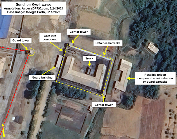
Close-up of the prisoner's barracks at the Sunchon kyo-hwa-so.

Other kyo-hwa-so, like the one in Sunchon (39.435983° 125.795632°), are smaller but provide the state with important commodities like gold. Sunchon is a forced labor gold mine which has expanded several times in recent years. Since 2010, the prisoner barracks at Sunchon has been enlarged 35% and security around the mining complex has been increased considerably. 


The largest of the prisons in North Korea are political prison camps (kwan-li-so), which can cover tens or hundreds of square kilometers and hold many thousands of prisoners. The government started building political prisons camps in the 1950s following a series of purges, and prisoners face long, often life-term sentences. 

At least fifteen of these large prison camps are known to have existed but several were closed in the 1980s and 1990s due to their proximity to the Chinese border. Many prisoners were transferred to other camps in the process.

Today, four kwan-li-so are known to remain: Kwan-li-so No. 14 (Kaechon), Kwan-li-so No. 16 (Hwasong), Kwan-li-so No. 18 (Pukchang), and Kwan-li-so No. 25 (Chongjin).

These expansive camps are further divided into two zones: the “revolutionary zone” and the “total control zone”. The “revolutionary zone” affords prisoners the chance at release after their sentences which includes ideological “reeducation” and hard labor. 

According to the UNHRC report, “total control zones” are for “inmates [who] are considered ideologically irredeemable and incarcerated for life.” The report further elaborates that anyone caught attempting to escape a total control zone is summarily executed. 


Administration and personnel (non-prisoner) housing of Camp No. 14.

Covering 155 sq. km., Kwan-li-so No. 14 (Kaechon) (39.569063° 126.058896°) is located on the banks of the Taedong River and holds an estimated 36,800 prisoners as of 2022. Through the use of forced labor in the camp, small factories produce a range of products including textiles, shoes, and cement. 

Prisoner housing district with new wall around it.

A review of commercial satellite images of the camp found that between 2017 and 2019 security around each prisoner housing district was increased with perimeter walls being added or rebuilt around them.

North Korea's prison camps provide millions each year to the state in economic benefits through forced labor in the agricultural, light industrial, and mining sectors. Coal is the most commonly mined commodity, and as can be seen in the above image, enough coal is mined at Kaechon that the train entering the camp is pulling 23 hopper cars, each with a carrying capacity of approximately 90 tonnes.


The main industrial center at Camp No. 16, showing numerous workshops and small factories.

Kwan-li-so No. 16 (Hwasong) (41.267932° 129.394091°) is the largest prison camp in North Korea by area, covering 549 sq. km. It has been alleged that prisoners from Camp 16 were used in the construction of tunnels at the nearby Punggye-ri Nuclear Test Facility.

It was reported that facilities at several camps including Camp 16 were expanded in 2014 to accommodate a large influx of new prisoners related to the purges associated with the execution of Kim Jong Un’s uncle, Jang Song-thaek. A review of satellite imagery does show a range of changes to Camp 16 that include additional prisoner housing, workshops, and infrastructure projects.


Camp No. 18's perimeter with new guard posts shown.

Kwan-li-so No. 18 (Pukchang) (39.562888° 126.077457°) is the oldest existing political prison camp, having been established in the 1950s. It was downsized between 2006 and 2011, but a review of satellite imagery shows that the camp is still active and that new guard facilities were constructed ca. 2014, and that an additional security fence was built ca. 2019.

Close-up of the prison's administrative district.

DailyNK reported that individuals associated with the failed 2019 Hanoi Summit between Kim Jong Un and President Donald Trump were sent to Pukchang for punishment.


Image of Camp No. 25 showing the outer perimeter fence and the main prison compound.

Kwan-li-so No. 25 (Chongjin) (41.833620° 129.726124°) is the smallest of the four active political prison camps and there are no first-hand witness accounts of life in the camp. Based on information released during the 9th International Conference on North Korean Human Rights and Refugees (2009), many of the prisoners at Camp 25 are religious leaders and their families, along with people of Korean-Japanese descent who became dissidents.

Camp No. 25 is the only example of a camp where the entire prison is administered as a "total control zone".

The Committee for Human Rights in North Korea noted a large expansion of the camp’s outer perimeter and the addition of seventeen guard posts in 2010. A review of satellite imagery by NK Pro also found that a light-industrial building was razed in 2018-19, a new 450-square-meter building was constructed in 2020, and that the prison’s main gate was renovated in 2023, among other findings.


Together, the kyo-hwa-so and kwan-li-so hold around 200,000-250,000 prisoners, with DailyNK estimating that the eight largest prisons held a combined 205,000 individuals as of 2022. There are also upwards of 700 other penal facilities such as pre-trial detention centers and local "labor training" facilities (rodong kyoyangdae and rodong danryondae) that hold thousands more.

Although the number of defections has dramatically decreased due to the "border blockade" instituted in the wake of the COVID-19 pandemic, the testimonies of those who continue to risk their lives crossing the border reveal that life inside of North Korea remains bleak. And for those languishing in Kim Jong Un's constellation of prisons, loss of their rights, attacks on their dignity, and physical abuse remains a daily occurrence. 

Despite a major increase in the level of knowledge and public reporting about North Korea, there seems to have been few if any meaningful changes in the country's human rights record or judicial system to redress the many deficiencies that have been highlighted by the UN Human Rights Council and NGOs from around the world.

Particularly in light of China's reluctance to enforce UN sanctions and Russia's abandonment of the UN Charter with respect to Ukraine (and subsequently engaging in patently illegal arms trade with North Korea), attempts to hold North Korea accountable for its gross violations of international law appear to face even greater odds. However, there are still multiple avenues that can and must be taken by individuals and individual nation states to prevent this behavior - which has been ongoing since the foundation of the DPRK - from continuing for another eighty years.


I would like to thank my current Patreon supporters who help make all of this possible: Alex Kleinman, Amanda Oh, Donald Pierce, Dylan D, Joe Bishop-Henchman, Jonathan J, Joel Parish, John Pike, Kbechs87, Russ Johnson, and Squadfan.

--Jacob Bogle, March 23, 2024

Sunday, February 25, 2024

A Review of the Sunchon Kyo-hwa-so

Located in the mountains west of the city of Sunchon, near a village called Unbong-dong, is a little-known reeducation labor camp (kyo-hwa-so) at 39.436033° 125.795551°. 

Kyo-hwa-so are for those prisoners the regime considers "redeemable". Detainees are required to undergo ideological training and must endure forced labor. According to the UN Human Rights Council Commission of Inquiry report, detainees are also likely to experience beatings, torture, sexual assault, and starvation rations. 

Photograph of similarly sized Samdong prison in South Pyongan Province. Photo: Asiapress, August 2009.

Several kyo-hwa-so have been the subject of detailed reports through the work of the Committee for Human Rights in North Korea and other organizations, but the Sunchon facility has no known survivors to offer up witness testimony. It was mentioned in the 2017 report Parallel Gulag, but I would like to take this opportunity to lay out its developmental history in detail.

Despite the sparsity of direct information, it is known that the prison is a gold mine that relies on forced labor. And through the analysis of satellite imagery, a lot more can be learned. 

The earliest commercially available high-resolution image of the camp is 2002. A review of Landsat imagery shows activity at the site in 2001, but there's little indication of a prison or mining activity prior to that; although, there is low-level deforestation at the site beginning in the late 1980s. If the prison existed before 2000, it was quite small. 

Sunchon Kyo-hwa-so in 2002.

In the December 9, 2002 image, buildings exist at the prison site but there are no obvious security features such as a fence or perimeter wall, and no obvious guard posts. 

This site is one of the first of what will become an extended mining region, and another mine entrance exists at this time 1.3 km to the west at 39.442718° 125.781264°.

Sunchon Kyo-hwa-so in 2006.

The next available image is from 2006. By then, a perimeter wall clearly surrounds the detainee facility and encloses an area of 1,400 sq. meters. The building covers approximately 280 sq. meters. The main mining facility and tailings pond were also enlarged.

Other mines near the kyo-hwa-so in 2006.

Elsewhere in the immediate region, additional mining sites have opened up by 2006, but none appear to be prisons.

Sunchon Kyo-hwa-so in 2009.

By May 2009, a new wing of the detainee facility was constructed, enlarging the building to approximately 370 sq. meters. This could indicate an increase in the number of detainees held at the prison. Also, the two corner guard towers were reconstructed.

Additionally, a small building immediately to the east of the detainee facility was razed.

The main mining building was also reconstructed and takes on the appearance of a typical ore processing plant, and a second tailings pond was opened. 

Sunchon Kyo-hwa-so in 2010.

By September 2010, where the building was razed in 2009, a new building was constructed in its place. The new building is ~210 sq. meters which is more than double the size of the older building. It could be associated with the prison's administration, but that can't be said with certainty. 

Based on the tailings ponds, mining activity during this period was being carried out at a consistent pace.

Sunchon Kyo-hwa-so in 2013.

Between 2011 and 2013, the detainee facility was enlarged yet again, with a further 80 sq. meters added.

Activity at the other nearby mines also increased at a similar rate to the activity at the kyo-hwa-so mine. 

Sunchon Kyo-hwa-so in 2017.

Between 2016 and 2017, a fence was added to partially block off the mine from the rest of the surrounding area. Prior to this time, there was no clear delineation between the mine's territory and the outside, civilian area.

Construction also took place at the detainee facility, with the addition of new walls (although incomplete in September). That work was finished in October 2017, bringing the size of the building to approx. 500 sq. meters.

Sunchon Kyo-hwa-so in 2019.

By the end of 2019, a more robust perimeter fence was constructed around the mine, completely enclosing it, and three guard towers were also added.

Close-up of the kyo-hwa-so detainee compound in 2022.

Between 2020 and 2022, the main administrative building of the mine was reconstructed. The mining facilities were also further developed.

Sunchon Kyo-hwa-so in 2022.

Based on the imagery, prisoners are transported from the walled detention facility to the mine via truck. The distance from the gate at the detention facility to the gate at the mine's fence is only ~36 meters, and then it's a further ~90 meters to the primary ore processing building.

View of the other mines in the area in 2022.

The other mines in the area have all been further developed and grown, but none of them have indicators of being part of the kyo-hwa-so, and thus likely do not use forced labor.  

Citing the Database Center for North Korean Human Rights, Parallel Gulag says that this kyo-hwa-so has an estimated detainee population of 400. Given the multiple expansions of the detainee barracks, I think it's possible that this prison now holds as many as 600 people.


Between the large kwan-li-so concentration camps, kyo-hwa-so reeducation camps, pre-trial detention centers, local labor training centers (rodong kyoyangdae and rodong danryondae), and military prison camps, North Korea operates a constellation of several hundred* penal facilities. The eight largest prisons are estimated to contain 205,000 detainees.

As evidenced by the Sunchon kyo-hwa-so, these detainees aren't simply serving a prison sentence but are used to help supplement state revenue. Millions of dollars' worth of gold and other minerals are extracted, and military uniforms, textiles, foodstuffs, furniture, shoes, and numerous other products are produced in the country's prisons. The revenue from those products can then be used by the Kim Jong Un regime to fund its other activities. 

Although some prisons have been closed in the last 15 years (the Hoeryong and Yodok camps), Pyongyang has merely been consolidating its prison camp system and putting resources into extracting as much as possible out of its captive population.


I would like to thank my current Patreon supporters who help make all of this possible: Alex Kleinman, Amanda Oh, Donald Pierce, Dylan D, Joe Bishop-Henchman, Jonathan J, Joel Parish, John Pike, Kbechs87, Russ Johnson, and Squadfan.

--Jacob Bogle, 2/24/2024


*Note: the Ministry of Social Security and the Ministry of State Security each operate short-term detention/interrogation facilities in nearly every county in North Korea. Additionally, the full extent of military-operated camps (such as Camp 607) and local "labor training centers" has not yet been discovered. 

Sunday, January 21, 2024

DPRK's Fuel Transport and Storage Network: an Introduction

North Korea doesn't have its own domestic supply of oil and relies on legal and illicit transfers of petroleum products for its economy to function. While AccessDPRK has documented the proliferation of gas stations around the country, those exist parallel to North Korea's traditional oil storage and delivery network, which it has maintained for decades. 

Pyongyang-Kaesong Highway gas station at 38.973769° 125.719252°. Image: Wikimapia/Mar12.

In much of the world, going to your local gas station is how most individuals get fuel. There are stations for cars, trucks, and there are dedicated fueling depots used for institutions that have large fleets of vehicles like municipalities. But until recently, getting fuel in North Korea wasn't so simple.

Sixty-nine percent of the 190 gas stations identified by AccessDPRK have been built under Kim Jong Un, and even those aren't enough to cover every town and village - let alone the needs of factories, universities, collective farms, and other organizations that operate multiple vehicles and pieces of equipment.

So, most organizations still rely on an older system of refueling. 

While the specifics of how this system works remains little understood, I feel that I have been able to locate enough of the infrastructure (which is often buried underground or in hardened structures) to write an introduction to this system that serves as the backbone of fuel delivery and storage in North Korea.

To place this system in context, I'll quickly review North Korea's petroleum infrastructure.

North Korea is only allowed to legally import 4 million barrels of unrefined petroleum products and 500,000 barrels of refined petroleum products (like gasoline and kerosene) each year under United Nations' restrictions.  

North Korea imports petroleum products via ship and rail transfers as well as from a single pipeline coming from China into Sinuiju, the PRC-DPRK Friendship Oil Pipeline. North Korea has two refineries but largely relies on the Ponghwa Chemical Factory which is nearest Sinuiju. 

This map shows where North Korea's refineries and main oil terminals are located.

From its refineries and system of storage depots at key coastal terminals, legal (and an ever increasing amount of illegal) petroleum products are then transported to intermediate depots around the country. 

As mentioned, part of the fuel is sent from those terminals via rail and then truck to the country's gas stations.

But as you can see, they are not evenly distributed around the country and also only provide a limited storage capacity.

The bulk of the nation's fuel gets stored elsewhere, at facilities large and small, and can then be transported to factories, farms, and other organizations that need to fuel their own vehicles and equipment.

Map of just some of North Korea's internal petroleum storage facilities.

I currently have nearly ninety of these internal storage sites located. As mentioned earlier, most of the facilities are either underground or located within covered/hardened bunkers, making their identification difficult. Most, however, are near railways and so I believe I will be able to locate a considerably greater number of them in the future.

But with the sites that have been located, I can show each of the steps from the main terminals down to the local level.

Nampo's key petroleum depot is located at 38.720407° 125.366678°. It is one of North Korea's most important petroleum storage facilities, and also receives shipments from vessels engaged in illegal transshipment operations. 

Currently it has fifteen storage tanks for different types of refined petroleum products. The depot has grown in recent years with two new tanks added since 2019, and there is prepared space for a further twelve tanks. Two additional facilities also lie within a few hundred meters from this site.

Taedong Storage Site 39.094303° 125.615255°

From the main receiving depots like Nampo, petroleum can be shipped by rail to intermediate storage facilities. This one is near the town of Taedong, west of Pyongyang.

The Taedong Petroleum Storage Facility.

At Taedong, four large storage tanks - each approx. 20 to 25 meters in diameter - are partially set underground and are covered with large mounds of dirt.

Oil is brought to them via a pipeline from a rail terminal 750 meters away. Once inside the complex, the main line splits into smaller feeder pipelines that can fill or drain each tank independently. Taedong is one of the largest of these internal facilities and is just 1.3 km away from five anti-aircraft artillery batteries, and it is covered by several surface-to-air missile sites as well owing to its proximity to Pyongyang. 

Within Pyongyang is a large, central storage facility at 39.082890° 125.707182°.

The complex covers 12.4 hectares and contains large storage tanks like at Nampo, and smaller tanks that can be seen in towns outside of the capital and even at gas stations.

From these larger storage facilities, the fuel is then distributed via tanker trucks to their destined town or village.

One such site is in Kuum-ni at 38.898954° 127.908719°.

In this 2004 image, the individual storage tanks are visible.

Kuum-ni lies on the rail line in between Changjon and Tongchon in Kangwon Province. Its storage site comprises fifteen tanks, each 10-11 meters long.

By 2013, the tanks have been covered up.

Over time, most of the open tank facilities like Kuum-ni have had their storage tanks placed in bunkers or covered over with soil. In this 2013 image, new vent pipes are visible as small white dots.

Civilian organizations (factories, farms, etc.) have their own on-site fuel storage, and can draw from these "community" facilities. Sometimes it's a considerable amount (thousands of liters) or just a few small storage barrels, depending on their individual needs. 

The military has its own fuel supply system, and their needs are prioritized over civilian organizations. 

This system, while theoretically efficient in a country lacking internal pipelines, is also prone to abuse as local party bosses have considerable influence over the local fuel supply. And, there many opportunities for fuel to be stolen or diverted elsewhere; from black market activity to diversion for personal use, and the occasional need to 'donate' fuel back to the government, an unknown but likely large percentage of the country's fuel supplies end up being taken out of normal availability.

Regardless of the inefficiencies in North Korea's supply structure and economic policies, the country has managed to continue to import far more fuel than UN limits allow, even through the border closures brought on by the pandemic. 

Given a lack of comprehensive data about North Korea's imports, monitoring other parts of the country's petroleum infrastructure, like the growth, renovation, or demolition of storage facilities, can provide additional insight into how much the country is capable of bringing in and storing long-term. 

Petroleum storage, while not always the most interesting subject, plays a role in North Korea's ability to withstand sanctions, border closures, and any future blockade during a war. Improving our understanding of this topic can also help us to gauge the strength of its economy and its ability to manufacture a range of goods. 


I would like to thank my current Patreon supporters who help make all of this possible: Alex Kleinman, Amanda Oh, Donald Pierce, Dylan D, Joe Bishop-Henchman, Jonathan J, Joel Parish, John Pike, Kbechs87, Russ Johnson, and Squadfan.

--Jacob Bogle, 1/21/2024

Friday, December 22, 2023

Farming on the Frontier

North Korea shares 1,369.3 km of border with China and Russia. Predominately demarcated by the Yalu and Tumen rivers, the border regions are mountainous, with the available farmland often squeezed into thin strips or even onto islands that completely flood every few years.

With a few exceptions, such as the plains around Taehongdan and Onsong, farming in this region doesn't contribute significant amounts to the national food supply. However, they are important locally as are the forests which harbor herbs, mushrooms, and other plants used for food and in traditional medicines, and access to these lands provides additional income to local farmers and foragers. 

But, the government's response to the COVID-19 pandemic has placed that access at risk.

Through the construction of two layers of border fence, the land in between has become subjected to additional checkpoints, and many of the forests have become completely off limits. 

Farmer and ox cart at the Migok Collective Farm (2008). Image source: Stephan (Flickr), CC BY-SA 2.0.

North Korea has attempted to secure the full border in the past but never succeeded in doing so until COVID-19. Using the pandemic as justification, even the most impassable parts of the border are now fenced off with over 1,000 km of new fencing and thousands of additional guard posts having been constructed.

Even in this mountainous region of North Pyongan Province, where the Yalu swells to over two kilometers wide in some spots, electrified fencing has been erected to prevent anyone from fleeing the country.

As seen in the next image, the double row of fencing cuts through not only mountainous regions but also through farmland, disrupting the typical flow of human activity in those areas.

Detail of the border fence. Location: 42.967323° 129.999220°

Sometimes those fences are separated by only a few meters but in other areas it can be as much as a kilometer. In total, over 260 sq. km. of farmland and forest lies between the two fences, cut off from easy access. 

In this area, 17 sq. km. of land (highlighted in green) have been cut off by the two rows of fencing. 

In other areas, the fences run much closer together. At the narrowest point in this image, they are only 60 meters apart.

The land that has always belonged to official farms continues to be cultivated, even in places where the fences are close together, but the secondary fence prevents farmers from easily accessing that land, placing an additional hardship on them. Furthermore, parts of the border are alleged to hold landmines and the placement of those mines could further complicate the farmers' relationship with the lands they're required to work.

Checkpoint example #1 at 42.540183° 130.443553°.

Checkpoint example #2 at 42.544376° 130.477298°.

Positioned along roads that pass through the secondary fence are small checkpoints to verify the identification of everyone that tries to enter the border region. Not all of the existing road network remains open, however, with the fence just cutting across the road, and closing it. By limiting the number of access points, North Korea can funnel activity through a more manageable number of fence crossings, increasing overall security.


However, the fence doesn't only impact official farms. Illegal plots of farmland (sotoji) have been an integral part of North Korea's black market economy for decades, and they play an important role in supporting local economies and supplementing local food supplies, with corn, cabbage, potatoes, and soybeans being common crops.

Although the land in between the fences (and the illegal farms it holds) no longer appear to be openly accessible, entry to the sotoji could still be possible by bribing checkpoint officers as bribery and corruption is already rife in North Korea. If bribes are required, however, that is yet one more slice of income taken away from farmers (who, in the case of sotoji, could be anyone from professional farmers, teachers, and miners, to retired persons). 

If, however, access to the land has been permanently blocked and many or most of the fields are no longer cultivated, then that will have a direct impact on the many small villages and hamlets that can be found along the border region.

Examples of sotoji found within the fenced area. Location: 40.622524° 125.280157° 

In this area (imaged above) northeast of Pyoktong, North Pyongan Province, sotoji comprise roughly half of the land with forests occupying the other half.

Nationwide, an estimated 550,000 hectares are suspected of being sotoji, and DailyNK estimated that some 20% of all grain grown in the country in 2007 came from these irregular farms. Of course, land use patterns evolve over time, but as Andrei Lankov wrote in 2011, "the percentage of land under the cultivation of sotoji owners roughly equals that under cultivation by state-run farms" in some counties that border China. And, indeed, numerous of these illegal plots can be found within the new border fence area.

Crop yields nationwide have struggled in the last few years, but there haven't been any studies yet that focus on the border area that might tell us how the sotoji have fared with the construction of the border fence.

Whether it's a border blockade cutting off cross-border trade and impacting the lives of thousands living in the villages and hamlets of the area, or whether it's the construction of scores of additional checkpoints between towns and counties, and even surrounding Pyongyang, the government has used the pandemic as an excuse to crack down on human movement in ways greater than ever before.

Unfortunately, the difficulties imposed by the dual-layer border fence system on local populations aren't likely to lessen as authorities continue to extend the state's power over the economy and the freedom of movement. 


I would like to thank my current Patreon supporters who help make all of this possible: Alex Kleinman, Amanda Oh, Donald Pierce, Dylan D, Joe Bishop-Henchman, Jonathan J, Joel Parish, John Pike, Kbechs87, Russ Johnson, and Squadfan.

--Jacob Bogle, 12/22/2023

Tuesday, November 21, 2023

Post-COVID Update - Onpho and Tanchon

With internal pandemic restrictions slowly now lifting and international trade beginning to resume (albeit still at much reduced levels), some projects that had been stalled as a result of COVID and the government's anti-pandemic policies appear to be making progress once again.

Here are two projects where measurable progress has been made.


Onpho Holiday Camp

After visiting the Onpho Holiday Camp and Hot Springs (41.656463° 129.526877°) in July 2018, Kim Jong Un criticized the facility for being rundown and ordered that it be modernized immediately. Onpho has a long history, dating back to before the founding of the DPRK, and had served as a getaway for the country's elite for generations (including being visited by Kim Il Sung), which explains Kim Jong Un's anger at the state of the complex and his rush to modernize it.

Construction work began almost immediately after his visit, but economic factors began to be a drag on progress. Coupled with the pandemic, there was almost no headway made through all of 2020. And, indeed, after the August 2020 AccessDPRK report on the site, there was little more to tell - with only marginal progress being noted in 2021 and 2022.

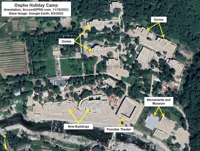
Construction progress as of November 2020 with several new dorms under construction as well as a number of other buildings. 

By 2022, all buildings had additional progress made but remained unfinished.

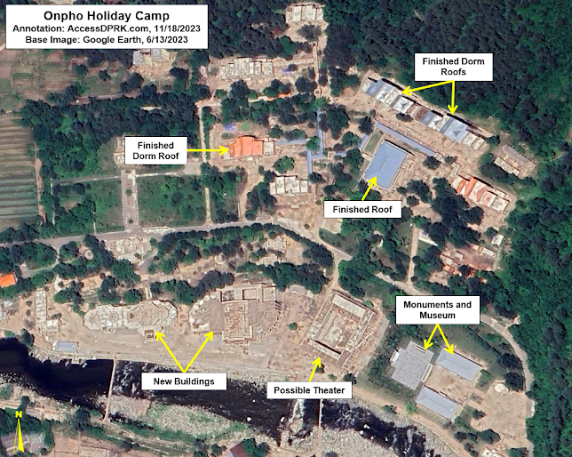
By 2023, some of the roofs had been put in place and the museum complex appears completed, but the three large, new buildings were still unfinished.

However, by September 2023, the exteriors of the three large buildings had all been completed four years after construction first began on them.

Onpho as of Sept. 14, 2023 showing that the exteriors of most buildings have been completed.

As mentioned earlier, Onpho caters to the country's elite. Located just a kilometer away, the complex contains at least eight villas of different sizes to accommodate important politicians, military leaders, and even Kim Jong Un should he visit again. However, the renovations to the holiday camp do not seem to have extended to this residential area.

While there hasn't been any official word as to when Onpho will reopen, the Yangdok Hot Springs (which underwent its own renovations from 2018-2019) reopened this summer after three years of closure due to COVID. But with the progression seen between June and September 2023 (the most in any three-month period since 2019), Onpho may finally be able to reopen next year unless there's another slow down.


Tanchon Hydroelectric Project

Path of the Tanchon hydroelectric tunnel and environs.

Plans to harvest energy from the Hochon River date back a century, but this latest endeavor began in 2017. With 60 km of tunnels, it's the largest hydroelectric project currently underway in North Korea. 

However, material shortages are a perennial problem on major projects in the country, and, made worse by the pandemic and border closures, the Tanchon Hydroelectric Project (40.787244° 128.444679°) still remains unfinished after six years. 

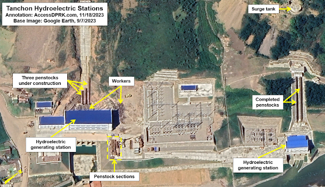
There was little noticeable progress made in 2022, but in the most recent Google Earth imagery, not only can progress be seen on the large penstocks, but crowds of workers are identifiable as well.  

Status of the Tanchon Hydroelectric Project as of Sept. 7, 2023.

If the penstocks are the final piece to the project (meaning that the generators are already in place), then Tanchon could come online in 2024, providing several megawatts of electricity to this key mining region. However, if North Korea hasn't managed to import or manufacture the complex turbine blades and generator components, then Tanchon may continue to sit idle for an indefinite period of time.


Despite the headway made at these two sites, there are still several others where no noticeable progress has been made, including on the Pyongyang General Hospital and the Wonsan Resort. The primary construction at both sites was completed over a year ago, but the government has not been able to acquire the necessary medical equipment and resort furnishings, leaving the sites as visible reminders of the government's overall inability to meet its own deadlines on some of its most publicized projects. 


I would like to thank my current Patreon supporters who help make all of this possible: Alex Kleinman, Amanda Oh, Donald Pierce, Dylan D, Joe Bishop-Henchman, Jonathan J, Joel Parish, John Pike, Kbechs87, Russ Johnson, and Squadfan.
--Jacob Bogle, 11/20/2023

Sunday, October 29, 2023

Inside North Korea 2023

As has become tradition with each new map release, here is a list of what's inside. Although this only reflects what the 2023 Pro Map captured, with over 70,500 sites mapped and organized into 100+ different types of location, AccessDPRK has sought to locate and describe every important military, economic, and cultural site within North Korea.

This latest release also gives me the opportunity to discuss in greater detail what the map contains as well as describe the improvements between this version and the 2021 version.


Without repeating the full backstory to AccessDPRK (which can be found throughout the blog), I began mapping the country in late 2012 as a hobby. Since then, it has ballooned into a methodical mapping project with this associated blog to share the various findings in detail. 

The AccessDPRK blog currently has 167 articles which would take up around 1,160 printed pages. I have also written for several other sites including NK News, Asia Times, and 38 North, and AccessDPRK discoveries have been reported on or cited by Radio Free Asia, Voice of America, DailyNK, UPI, Asahi Shimbun, Nikkei, The Atlantic, RAND Corp., and numerous others.

I've also been able to provide professional services to nearly a dozen of the top human rights, nonproliferation, and GIS organizations in the world.


Within the 2023 Pro Map update, more than 70,500 sites are included. This is a net increase of over 17,000 sites compared to the first free nationwide map that I made available back in 2017, when considering all the different changes that have occurred since.

With this update, I have tried to focus on mapping out changes specific to Kim Jong-un's rule as well as monitoring the evolving infrastructure changes due to COVID-19.

As with all my North Korea maps, the file is organized into four main divisions: monuments, military, domestic, and nationwide. The item counts that I've added further below gives even more details, but the general organization of the map is as follows.

The monuments folder is broken down by province and includes folders for Towers of Immortality and a folder for all other monuments. Many of the locations have notes on the type of monument they are (mural, statue, etc.) as well as dates for their construction.

The military folder is broken down by province and there is one for the DMZ. In total, there's over 40 subfolders for specific types of places like anti-aircraft artillery positions, navy bases, military storage sites, tunnels, etc. 

The domestic folder is broken down by province and also contains over 40 subfolders for specific types of places like dams, electrical substations, factories, markets, elite housing, schools, train stations, etc.

Both the military and domestic provincial folders also have an "uncategorized" subfolder that contains numerous other sites of interest that didn't warrant having their own dedicated folder (typically because there were just a handful of sites). And, most provinces also have at least one other folder that contains places unique to that province.

For the nationwide folder, that contains ten categories of places that I felt were better organized together instead of being spread out among each provincial folder. Nine categories would be considered "domestic" and one (the folder for ballistic missile bases) would normally be in the military folder.


Compared to the 2021 Pro Map, this update is only 9% larger; however, there were several thousand internal changes to existing sites along with the 9% of newly mapped ones. I go through some of those specific changes below.

Monuments


The 2023 Pro Map includes 711 additional monuments over the 2021 version. This is largely due to updated imagery compared to what was available at the end of 2020, when I was finalizing the 2021 map (released that January). But there are also examples of monuments being constructed throughout 2021-23 (and those construction dates are included). I was also able to remove a few monuments that had been demolished, and to move the position of the icon for several other monuments that were moved to new locations. 

Additionally, and this goes for the military and domestic sections as well, I tweaked the position of hundreds (if not more) of icons to address the "drift" that happens when Google Earth updates its imagery. The images are rarely laid along the precise same coordinates so, after a few years, the Google Earth icon's position may no longer exactly match the position of the object in the image - sometimes by as much as 10 meters. So, I tried to make as many of those corrections as possible.

In the process of updating the monuments folder, I noticed some clear construction trends and periods of greater building activity. I've already written two detailed reports (2019 and 2021) on the monuments in North Korea, but I may write one last one in the future that will discuss these observations in more detail.


Military


The 2023 Pro Map only has 233 net additional military locations compared to 2021, but there were quite a number of other changes to the folder.

For one, roughly 40 anti-aircraft artillery sites in the 2021 map were reanalyzed and determined to not be active sites, so they were recategorized as "decommissioned" and moved into that folder. 
Several new AAAs that were constructed recently are also now included, making this the most up-to-date map of North Korea's air defense network.

Surface-to-air missile bases, which had been included in the same folder as AAAs, were separated out into their own folder. The exact type of SAM (S-75, S-200 etc.) was also added to those sites as well as information on the nine suspected mock SAM installations.

I reviewed the DMZ to ensure I located every pertinent site, and I took the opportunity to redraw the various fences so that they match the terrain more closely. 

The Airport file now includes known civilian "aviation clubs" and also reflects the fact that several airports and airbases have been demolished in recent years.

Within the rest of the folder, I added radar system identifications to dozens of sites and reviewed and improved the classifications of sites within the "possible units", "compounds", and "factories" folders. I also added additional data to "military units" and "tunnels" when available. 

Domestic


The domestic section ended up with the largest number of additions by far with 12.5% more sites than in 2021.

This is in large part due to COVID infrastructure, but I was also able to pick up on a number of new constructions, located formerly unknown sites, and I also added the country's network of forest management centers (located within the farming/agriculture folder), and improved the disposition of Pyongyang's water supply system - that alone added nearly 100 extra sites.

As for COVID. I remapped the entire northern border and both coastlines as North Korea began to rebuild and install new electrified fences along those areas to seal the country off. The 2021 map had positively identified 1,693 km of coastal and border fence (excluding the DMZ). The 2023 update has identified 3,684 km of new and modernized fencing. 

Along with the fences, I estimate that North Korea constructed an additional 15,000 border guard posts. To keep myself from going crazy mapping each and every one of those, I have picked a representative sample by mapping random ones. Nonetheless, 4,575 guard posts and guard barracks are individually identified within the map.

Additions based on COVID infrastructure continue through the discovery of COVID isolation facilities built throughout the countryside (109 are presently located), and the discovery of an anti-pandemic barrier that's being built around Pyongyang. The barrier alone accounts for 320 new sites. 

Some of the other changes include 47 additional dams and weirs, 56 additional communication towers, 35 additional electrical substations, 26 newly identified marketplaces, 185 extra farming/agricultural facilities, 41 extra schools, 18 additional historic sites, 38 extra gas stations, and around a dozen newly identified prisons/detention centers. 

Among all of this, I also moved ~1,200 sites (of all types) out of the Pyongyang folders and into folders for North Hwanghae and South Pyongan provinces because Google Earth finally got around to correcting their borders. And, roughly 800 sites had additional information added to them such as construction dates, notes on renovations and major events, and relevant news links.


Notes: 

I want to add a few notes to help with context and prevent any confusion.

While most of the categories are indeed individual sites (there are 1,520 distinct electrical substations for example), some of the categories include not just the primary location but also sites within those places. A great example of this is that there are not 434 prisons in the country. There's 67 known, suspected, and former prisons that I was able to locate. And many of those prisons include detailed maps that also mark where the guard huts are, where prisoner housing is, and so on. So, one prison may be represented by 20+ items, and that's how I get to 434 total sites within the prison category.

The categories that have these more detailed folders are prisons, missile bases, some historic sites, several of the "elite compounds", and a few factories. Additionally, some of the "province only sites" include multiple sites per place. This is especially true in Pyongyang which has the most of these province-only sites. An example is the Ryongsong Residence, which located within the "province only" folder, but that one residence includes 47 detailed sites within its folder. So, while there are 1,043 markers within the whole "province only" category, they're only representing ~300 primary places as several of those primary places have numerous sites marked within.

Lastly, in some cases I did not try to map every single one of the sites within a category. There are notes in the respective folders saying this, but they are: irrigation pumping stations, water supply, factories, agricultural sites, internal security checkpoints, parks, and gates. I tried to map a majority of sites and all of the important ones with the exception of the water supply sites, agricultural sites, internal checkpoints, and gates. For those, I wanted to give a representative sample and to locate major places. I only marked gates in cases where a facility was large and the main entrance could be difficult to find, and in cases where the gate itself was interesting/large.


I would like to thank my current Patreon supporters who help make all of this possible: Alex Kleinman, Amanda Oh, Donald Pierce, Dylan D, Joe Bishop-Henchman, Jonathan J, Joel Parish, John Pike, Kbechs87, Russ Johnson, and Squadfan.

--Jacob Bogle, 10/28/2023

Friday, September 15, 2023

Pyongyang: COVID Fortress

AccessDPRK has been at the forefront of using satellite imagery to uncover North Korea's anti-pandemic measures. It was the first to use satellite imagery to verify reports of the "border blockade", it was the first to offer a nationwide look at those border changes via the AccessDPRK map, and it was the first to expose a network of covert COVID isolation facilities that was built across the country.

Screenshot of KCTV program (July 27, 2020) showing a COVID disinfection checkpoint along the Pyongyang-Kaesong Highway. Image source: NK News.

North Korea has used the pandemic to clamp down on human movement and trade in the most extreme ways, and it has relied on myths and pseudoscience to back up its policies. From claiming that COVID could pass into the country from Chinese dust to putting people in quarantine for coming into contact with objects from South Korea - despite there being very little evidence that one can contract the virus by simply touching an object - North Korea's anti-pandemic measures have caused an inordinate amount of harm.

Of course, given the state of the country's healthcare system, any pandemic could pose an existential threat to the state (to say nothing of the people living there). That is why it's little surprise to discover that authorities embarked on building not just border and coastal fences but have tried to erect an anti-COVID barrier around Pyongyang itself. 


First, however, I want to review the other infrastructure changes that North Korea has instituted in its fight against COVID.

North Korea was the first country to completely close their borders in response to the COVID-19 pandemic. To accomplish this, not only were all border crossings closed and trade & tourism suspended, but authorities erected hundreds of kilometers of new border fence (often in two layers) as well as repaired and modernized the existing border fences.

Map showing all border and coastal fencing as well as fences along the DMZ.

As part of the border closure, they added over 15,000 additional guard posts and garrisons along the border with China and Russia. They also improved security along both coastlines. AccessDPRK has verified the existence of 2,008 km of northern border fence and 1,567 km of coastal fence that now ring the country (plus hundreds of kilometers of DMZ fences). 

Within the country, numerous checkpoints were set up to further limit human movement and the spread of the disease. Some of these are simple tent-like structures where a person's temperature can be taken, and others are existing vehicle inspection points that have been expanded to allow for decontamination processes.

At the border crossings, most have simply remained shuttered. But at Sinuiju (the main crossing with China) and Tumanggang (the only crossing with Russia), new facilities to quarantine and disinfect goods and people were set up to handle what little trade has occurred since 2020, and to prepare for when trade is normalized again. There is also evidence of disinfection infrastructure being built at the ports of Nampo and Tanchon.

Location of all identified COVID isolation facilities. 

And as part of actually providing a level of medical care, albeit a questionable level, dozens of suspected COVID isolation facilities (95 at last count) have been constructed throughout the provinces. These highly secured compounds can isolate patients who test positive with COVID or have a severe "unidentified" fever, while not taking up additional room in the country's poorly staffed and supplied hospitals. Within Pyongyang, the city's hospitals have all had dedicated COVID wards set up.

It is within this context that I want to detail the latest apparent COVID infrastructure project: fencing off Pyongyang itself.

Map showing the location of the capital COVID fence. The yellow lines represent confirmed fence paths. The white lines represent rows of guard posts that may or may not be connected by fencing.

Because there are gaps in the available image data from Google Earth, I haven't been able to map out the full system as it exists today, but I have been able to locate enough of it to provide this review.

Beginning no earlier than March 2020, the construction of a series of fences, guard posts, garrisons, and checkpoints began. In parts of the city, the first iteration of the system was already built by October 2020, while in other areas construction extended until at least June 2022. 

Detailed look at the fence with a garrison building and guard posts visible.

Another detailed view of the fence. The fence's path is clear as are the guard posts and foot patrol path.

Based upon the available imagery, there are at least 63.2 km of clearly identifiable fencing with a further 22.9 km of rows of guard posts that may or may not also be connected by fencing. The guard posts are typically spaced every 75-100 meters. With 86.1 km of fenced and unfenced guard post lines, that means that roughly 1,000 guard posts (between 861 and 1,148) have been constructed around the city. 

Locations of garrison (barracks) buildings.

Just like with the country's border fence, these posts are supported by a network of at least 28 purpose-built garrisons (barracks) - six of which were actively under construction in June 2022. There are several other sites that I believe are now being used as garrisons, but they were previously used for other purposes. I haven't included them on the map because of a level of uncertainty. 

Locations of identified checkpoints, both pre-existing ones and newly constructed.

The fence system is also interconnected with the capital's checkpoint network and consists of 35 checkpoints of various types. Of those, twenty were built since 2020 and several of the preexisting sites have had visible upgrades. 

Explanation of gaps in the fence system. "Image gaps" refers to a lack of more recent imagery available on Google Earth.

There are parts of the terrain around Pyongyang where I have not been able to identify any new fencing. However, some of these areas are already "protected" by existing fences from factories or agricultural places, and those fences have been incorporated into the new system. Additionally, large sections of eastern Pyongyang are afforded security by the wide Taedong River (which serves a natural physical barrier), and northern sections of the city are mountainous and filled with military bases - effectively creating large swathes of inherently restricted territory. 


Thus, Pyongyang now sits at the center of a multilayered security network; a city that already required permits to visit, can now shut itself off from the rest of the country at-will. This doesn't only include restricting traffic from the main roads (an ability that has always existed), but even prevents Pyongyang farmers from coming too close to the city core by merely crossing a field on foot. 

The Central Quarantine Command oversees Pyongyang's anti-pandemic measures, instituting lockdowns, and enforcing the various government orders relating to the pandemic. However, whether or not this capital fence system is subordinate to the CQD, is part of the capital police force, or is part of a multi-agency force isn't yet known. 

I reached out to several North Korea experts including those with access to information from within the country, and only hints of information about this fence have begun to make it to outside researchers - and there had been no independent verification of it until now. It seems that North Korean authorities have been keen on keeping it a secret. 

However, as defector and former Pyongyang resident Hyun Seung Lee told me, it is "highly possible [that such a fence was constructed] since the country's top priority is Kim Jong Un's health. If anything COVID-19 related happened inside North Korea, none of the authorities will be free from responsibilities to protect the leader."

Considering the large number of checkpoints that already restricted access to Pyongyang, it may seem redundant to build dozens of kilometers of fences and a thousand guard posts to further cut off the city. Yet, North Korea not only built over 15,000 additional guard posts to seal off their northern border they also built fences all along the coastline. And so, North Korea seems to fight viruses with the same tactics as they would an invading army - block the enemy from being able to move. In this case, the general population plays the role of "enemy".

Although North Korea appears to be preparing to reopen its borders, it's clear that they have invested in the physical infrastructure needed to reenter lockdown at any time, and to continue to further restrict human movement within the country. This latest discovery underscores the paranoid nature of the state and demonstrates how Kim Jong Un would rather resort to force (sealing off the capital and placing thousands of guards on patrol) than take helpful steps like granting general access to vaccines or allowing adequate humanitarian aid into the country. 


I would like to thank my current Patreon supporters who help make all of this possible: Alex Kleinman, Amanda Oh, Donald Pierce, Dylan D, Joe Bishop-Henchman, Jonathan J, Joel Parish, John Pike, Kbechs87, Nate Odenkirk, Russ Johnson, and Squadfan.

--Jacob Bogle, 9/15/2023