Showing posts with label military. Show all posts

Friday, August 25, 2017

Kim Jong-un's Spy School Gets Upgrade

North Korean soldiers during an annual military parade.

One of North Korea's main espionage facilities, located in northern Pyongyang, is growing.

North Korea (with their several government agencies and branches of the military) has a long history of espionage and infiltrating South Korea. The DPRK also has one of the most active cyber warfare units in the world. Both the military and various agencies have a substantial amount of overlap.

According to defector Ahn Myung-jin, one of these facilities (which is near Kim Jong-il Political-Military Academy, also a spy school) is under the Strategic Division of the Central Party Espionage Department. The espionage training annex has a large underground facility with a tunnel 12 meters high, 30 meters wide, and 8 km long. It contains scale models of Seoul, important buildings like the Blue House, and even "functional" areas where officers can get used to going to shopping centers and using currency. The training period within the tunnel can last 15 days to a month each year.

As a reminder, clicking on the images will allow you to see larger versions.

This Google Earth image shows you the location of the espionage center (top) and surrounding points of interest.


Given its association with the Kim Jong-il Political-Military Academy, it is probable that this site is under the control of the General Reconnaissance Bureau, which is in turn controlled by the National Defense Commission (instead of the Korean Worker's Party which has its own intelligence agencies).


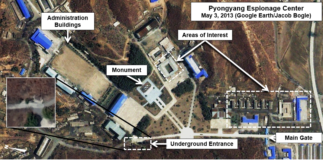
In this image from 2013, you can see the key areas of the center, including the underground tunnel entrance which also has an insert from another angle to allow you to see the actual opening. The two "areas of interest" are the main sites that will be changing.

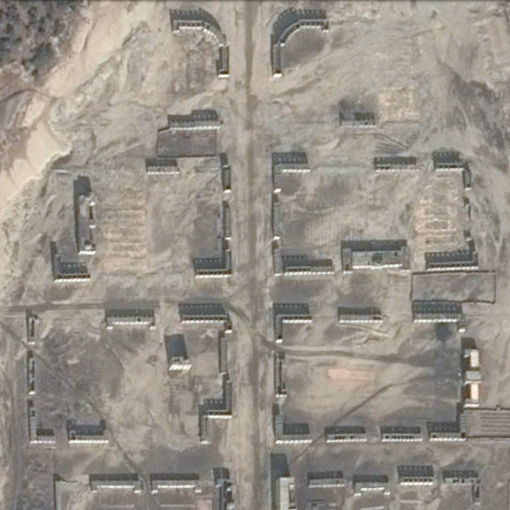
On Nov. 9, 2015, commercial satellite imagery showed a building undergoing some type of alteration. The building had been emptied and the roof removed. It also shows that a collection of greenhouses near the main gate had been removed.


Fast forward to May 2016, and the first building mentioned above has been torn down to its foundations. A new building can be seen under construction as well.


The latest freely available commercial imagery is dated April 22, 2017. There is a lot of activity that can be seen.


The first buildings pointed out in earlier images are basically completed. However, there is new construction going on in two additional sites, plus a further building being torn down. The entrance gate is also undergoing some kind of an upgrade.

These changes will add at least 32,000 square feet (2,972 sq. m) of additional floor space. The site labeled "New Construction Site" is the location of an earlier building that has been demolished. If a new building is constructed and occupies the same footprint, that would modernize a further 39,000 sq. ft (3,623 m) of space.

To top it all off, the monuments are being changed, too. As I have written about extensively, monuments to the leaders (as part of the pervasive personality cult) are an integral piece of every military and civilian institution in the country.


The original monument was a group of 4 bronze figures, as seen above. The monument has existed since at least 2005. Sets of solar panels are also visible. These panels can first be seen in March 2016.

What is interesting is the lack of a central statue of Kim Il Sung (joined by statues of Kim Jong-il after his death in 2011). Nearly every major site in the country has such statues (to go along with murals and other smaller monuments).

It appears they've rectified this. On the April 22, 2017 image, the group of statues has been removed and now only spaces for two new ones are visible. This change also suggests, in my opinion, the elevation in importance of this complex.


In this image you can also see a close-up of some of the building construction going on. Near the statue place (which is on top of a mound) are piles of construction/landscape materials. The monument mound will be resurfaced with grass and other plants, the stone steps leading up to the statues themselves will be new, and it's likely the whole courtyard will be refaced with new stone.

The solar panels have been removed as well. It's probable they were only used to help power necessary construction equipment or needed lighting since a stable supply of electricity is still a problem, even in Pyongyang.

There are many examples of military locations being modernized, and various related construction projects are underway all over the country. While specifics are hard to come by for most of these places, what we can learn from satellite imagery is that large sums of money are being poured into defense (from the regular Army and Navy, to the Strategic Missile Forces and covert operations agencies). With this site in particular, we can see that an increased training capacity is being planned (as evidenced by the added square footage) and that the nation's leadership is keeping a close eye on the place, making its importance greater.

--Jacob Bogle, 8/25/17

Additional Reading
(38 North Special Report, by Joseph S. Bermudez, June 2010)

Tuesday, July 4, 2017

North Korea by the Numbers


Phase II of the #AccessDPRK Mapping Project was published on March 5, 2017, but simply knowing where everything is doesn't make understanding the full picture much easier - especially when considering there's over 50,000 places marked. So I've put together these basic charts showing the total number of items per division (monuments, military, and domestic), the total items per province, and the total number of items within each type mapped (AAA sites, elite compounds, dams, communication centers, schools, etc.).

I'd like to point out that the overall figures here will differ slightly form the ones listed in the March 5th publication article. All told, there are some 600 individual sub-folders I have to keep track of and the resulting numbers take up 24 pages; minor mistakes happen. A couple numbers were inverted, and a few others were slightly off, however the overall discrepancies are very minor when compared with the whole. After making those needed corrections, the information below should be considered as authoritative as it will get with regards to the project.

The following charts (monuments, military, and domestic) represents the most detailed map of North Korea ever released to the public.


Many monuments are clustered closely together, making marking each one individually impractical. Instead, some markers are placed next to a group of monuments (2-4 generally), so while Pyongyang may have 1,049 markers on the map, those markers represent 1,230 individual monuments.

It's important to note, for those unfamiliar with the project, that the numbers below represent the numbers within the various folders by those names. There will be some items where there will only be one or two places within a province - those didn't necessitate their own folders. In such cases, they're often located in the "un-categorized" folder. An example of this is military training centers and military factories. Just about every province has at least one, but only a few have a folder dedicated to them.  A similar situation exists within the domestic file; bunkers, water towers, jails, and others may or may not have their own folder, but they will all be mapped.


While the purpose of this project is to map every one of a particular item, there are some items that I did not intend on mapping each and every one of, such as "firing positions". These trenches and prepared (but empty) gun positions cover the country and number in the thousands. In many cases it's also difficult to determine whether or not something was just a leftover temporary fortification from the Korean War or is part of the country's current defense structure (which does include having trenches in just about every available space). Additionally, the "radar" count is predominantly stand-alone radar sites, not the numerous smaller radars that accompany permanent artillery positions; although some of those are mapped as well. "Gates" are only mapped when they help define the boundaries of an area or are large - there's no real need to map every single gate at every single military site.

With the exception of a few items: canals, signs, factories and farming (to a degree), mountaintop sites, gates, and water supply, I have tried to be as comprehensive as possible in mapping each and every one of the other sites. Regarding the number of factories and farming/agricultural facilities, I focused on only mapping the larger sites, while also mapping some smaller agricultural facilities (like wheat threshing sites) to provide examples of what those numerous places look like. 

In short, the map contains 8,865 monument markers (representing 9,896 individual monuments), 9,594 military sites, and 35,252 domestic and economic sites for a total of 53,711 placemarks. There are also hundreds of fences and other things outlined in the map, but those aren't included in the counts as the places fenced in have already been accounted for.

#AccessDPRK will occasionally be updated to provide greater accuracy as new information comes in, fixing any unintentional errors, and adding more details.


--Jacob Bogle 7/4/17
JacobBogle.com
Facebook.com/JacobBogle
Twitter.com/JacobBogle

Friday, January 6, 2017

New launching/landing sites constructed?

UPDATE: These have been confirmed as emergency parking positions for jets, since highways can be used as auxiliary airfields (and North Korea does have at least 14 official "emergency highway strips").


On the heels of Kim Jong-un suggesting that the country is very close to testing another ICBM, I've discovered three sites that could be used as dedicated mobile-missile-launcher pads.

These sites were constructed in 2016 and have the same general design.

The first and largest is near Kaesong and lies less than 10 miles (16 km) from the Demilitarized Zone with South Korea.

Located adjacent to the Pyongyang-Kaesong Highway, by the village of Haeson-ri, this site was under construction in March and had been completed by October 2016.

Each pad is 45 feet (14 meters) wide and the straight portion is 175 feet (53 meters) long. The area around it also contains numerous bunkers and tunnels.

The second site is in Pyongsong, South Pyongan Province, which is 21 miles (34 km) north-northeast of the center of Pyongyang.


Just like the Kaesong site, this one is located adjacent to a main highway. In this case, National Highway 65. The area also has a high concentration of HARTS (Hardened ARTillery Sites), which are marked by the red dots. Several additional military facilities are also nearby.


Lastly, the third site is similar in its size and the fact it's right off a highway, but its design is different. The primary difference is a lack of a central berm. This site is located near Sukchon, also on South Pyongan.


If these are indeed dedicated pads for launching missiles, it would be in line with North Korea's continued modernization and expansion of their offensive capabilities.

________________________________________________________________________________________
I'd like to make a quick note about the #AccessDPRK Mapping Project. Across North Korea, I have located 9,500 military related places. I have finished the primary mapping process and am now working on incorporating the work of two others into a main and comprehensive single file. After that, the entire body of work will be published.

--Jacob Bogle 1/6/2017
www.JacobBogle.com
Facebook.com/JacobBogle
Twitter.com/JacobBogle

Sunday, March 13, 2016

Urban Combat Training Centers

North Korea has one of the largest conventional standing armies in the world, but much of its equipment is outdated and would be woefully inadequate against a direct force-to-force conflict with South Korea and the US. However, its 1.2 million person military isn't just made up of regular soldiers.

Outside of the nuclear threat, the one area that has many military analysts concerned, is North Korea's asymmetric warfare capability. The country's Special Operations Force has around 180,000 troops that are highly trained, motivated, and specialize in infiltration, terrorism, urban combat, and other methods. There are four known urban combat training centers in North Korea, with an alleged fifth underground site somewhere around Pyongyang. On top of the urban combat sites, there's a further 23 large military training grounds. SOF training lasts 3-6 months and covers a very wide range of tactics.


While the exact date the SOF was formed isn't known, it is clear they've been active since at least the 1960s. Between 1953 and 1999, the DPRK committed over 76,000 transgressions against the 1953 Armistice Treaty. Among those, we know that the SOF was used in the 1968 Blue House raid which was an unsuccessful assassination attempt on South Korea's then president Park Chung-hee and resulted in 30 ROK-US fatalities as well as the suicide of 29 of the North Korean operatives. There was also the 1983 Rangoon bombing in Burma (another assassination attempt) that resulted in 67 casualties.

Here's the coordinates to the four training centers:
N. Hamgyong Province:  38°24'2.01"N   126°22'14.29"E
N. Pyongan Province:  40° 0'46.89"N   125°53'8.94"E
Pyongyang-Kangdong: 39° 4'50.13"N   126° 5'33.99"E
Pyongyang South:  38°58'1.08"N   126° 6'20.62"E

The largest of the urban combat centers is located 16 miles north-east of the Yongbyon nuclear site in North Pyongan Province. It has a full-scale downtown mock-up that's half a mile wide on each side.

Here's a section of the "town" with the buildings arranged in rectangles.


Pyongyang has two known urban warfare centers. Both of them are to the far east of the city center and are 8 miles apart (nearly in a straight north-south line). The southern base has buildings of a slightly more modern design, while the northern one is more traditional.

The southern site:


The northern one is near the town of Kangdong, Pyongyang, known as Soe-gol.


There is also an alleged site in Pyongyang which is mentioned in Bradley Martin's book "Under the Care of the Fatherly Leader", and is described by defector Ahn Myung-jin as being underground near the country's primary espionage training complex and is supposedly dedicated to training spies and other special forces to infiltrate & attack Seoul. It has 8 kilometers of tunnels and is an exact small-scale replica, outfitted with operational stores, residences, government buildings, and even allows them to "buy" things in the stores so they can get used to the way of life in South Korea - before attempting to destroy the city. There are many underground facilities and tunnels in Pyongyang, but I haven't been able to find likely locations for such a compound.

For a bit of international context, here is an urban combat facility in Fort Bragg, NC USA.


For some more information on North Korea's Special Operations Force, you can read the report "Countering North Korean Special Purpose Forces" by Australia's Air Command and Staff College. (PDF link)

There's also the book "North Korean Special Forces" by Joseph S. Bermudez. (link to Amazon)


--Jacob Bogle, 3/13/2016
www.JacobBogle.com
Facebook.com/JacobBogle
Twitter.com/JacobBogle

Saturday, March 5, 2016

Phase 1 Map Complete!

AccessDPRK Phase I Release


Three and a half years ago I embarked on the ambitious project of mapping the whole of North Korea; a project called "AccessDPRK". I have always had a fascination with authoritarian regimes and for some reason my specific interest in North Korea began to grow a little over three years ago. I also have had a deep love of maps and geography since I was a very young child.

As my interests piqued, I started using Google Earth to look at North Korea. What I found were informative “community placemarks” marking the location of a monument or military site. I looked into who had created those placemarks, which seemed to cover the entire country, and found that they were part of a project called “North Korea Uncovered”. Created over the course of two years (2007-09), by George Mason doctoral candidate Curtis Melvin and a few volunteers, the project created the most comprehensive map of the country to-date. It included thousands of placemarks (approx. 9,000) – monuments, factories, palaces, artillery batteries, ancient tombs, and so much more. There was also another person, a Google Earth user known only as “Planeman_”, who created a map of supposedly all the artillery sites in North Korea.

However, as I explored these large files, I quickly discovered that there were massive holes in the data. While they marked some locations of each general type of item, the resulting creation was far from truly comprehensive. For some reason this offended me (in a lighthearted way), and since I am slightly obsessive and had an inherent interest in the country, I decided to take it upon myself to make the most comprehensive (at its fullest meaning) map of North Korea any private citizen has ever made by going and marking all of the locations not marked in Melvin’s project.

Once completed, I would release the information in the form of a Google Earth file to the public via my website, blog, and the Google Earth Forum. The goal being to expose the entirety of country to the world. To show people not just how the physical infrastructure of the nation is laid out (like power plants), but to also give a glimpse of daily life by having marketplaces, parks, as well as historical locations lost to Western knowledge, and much, much more. After the completion of “Phase I”, I also intend to review Curtis Melvin’s file and make any necessary corrections to it (since it is now six years old) and combine the two projects into a single “master file”. Little did I know what this full endeavor would require.

On Nov. 28, 2015, I finished the initial mapping phase of my project. After three years, over a thousand hours of active mapping work, and delving into thousands of pages worth of material to assist in creating this map, I now have seen every square mile of the country – indeed every home. The resulting Google Earth file is nearly 3 times the size of Melvin’s and contains 28,164 additional placemarks.

The file is divided according to each of North Korea’s primary administrative regions. Each is then further divided into 3 main categories: Military, Monuments, and Domestic. The Military and Domestic categories are subdivided into several sub-categories, such has anti-aircraft artillery sites, military bases, naval sites, and on the domestic side, dams, electrical substations, schools, factories, etc. All told, there are over 50 subcategories. Beyond those province specific folders, there’s are folders exclusively dedicated to the Demilitarized Zone, the country’s airports, historic places, etc.

One reason why this has taken so long is that as I would go around the country, I would find new categories of places that were numerous enough to have a national impact, like irrigation pumping stations and radar sites. So as I would add these new categories, I would have to go back an re-map formerly "completed" areas. 

The ultimate end of this project is not yet known. Like the development of the Internet, I’m not fully aware of the possibilities that can arise once people start mining the data. You could create a comprehensive map of North Korea’s electrical grid, you could discover their current defensive military strategies and find holes in their air defense system, you could work out how their internal security system is integrated across various transportation modes, and I’m sure many other things.

In addition to mapping, I’ve also written dozens of posts for this blog as well as 6 Wikipedia articles which have been read a combined 400,000 times and translated into multiple languages.
My main wish is that this can be used to help the world see that North Koreans are normal human beings who have been held hostage by their government. And that this provides some insight into how that government works to further the work of others in opening up North Korea, and one-day help bring North Korea into the 21st century with a respect for freedom.

Phase II is already underway, and I have marked over 5,000 new places thus far. These include public schools, universities, museums, theaters, town halls, and other "buildings of interest". This is going to take some time to complete, but I'm hoping to have everything (including the "master file") finished and ready to be published by the end of the year, if not sooner. 

Here are a few specific item counts:
Anti-aircraft artillery batteries: 587    Hardened Artillery Sites: 626    Military bases: 938    Monuments: 6,720   Dams: 1,169   Communication towers: 747   Electrical substations: 736
Factories: 470    Marketplaces: 225    Ancient sites: 112


Get the File!

If you want to discuss the project on social media, please use the hashtag #AccessDPRK either on Twitter or Facebook. I welcome comments and suggestions, as well as new information.

To access the Phase I Google Earth file, you can either visit my file archive here and click the download button for "AccessDPRK Phase I_Finish_V1-March-5-2016.kmz" or download it directly by clicking this link. To view the file you must have Google Earth on your computer/device. NOTE: this is a large file (over 28,000 items). For some computers Google Earth might freeze or crash if you try to have every province open at once. Just go through them one by one if you're unsure. 

All Google Earth KMZ files relating to this mapping project are hosted on my Google Site https://sites.google.com/site/mymappingprojects/access-north-korea


-- Jacob Bogle, 3/5/2016

Sunday, November 15, 2015

North Korea's Air Force & Airports

NOTE: Scroll to the bottom to download a Google Earth KMZ file of all airfields and heliports.


Introduction

The Korean People's Army Air Force was created in 1947 and is one of five branches of the Korean People's Army. Today it has around 1,000 aircraft with 110,000 personnel. Given the military primacy system (Songun) of North Korea, we might as well consider domestic and military aviation controls as one and the same.

The KPAAF is currently divided into six divisions: 1st Air Combat Command (HQ at Kaechon), 2nd Air Combat Command (HQ at Toksan), 3rd Air Combat Command (HQ at Hwangju), 5th Air Transport Division (HQ at Taechon), 6th Air Transport Division (HQ at Sondok), and the 8th Air Training Division (HQ at Orang). These are all controlled by the central Air Defense and Combat Command which is headquartered in Chunghwa, Pyongyang.

(As always, click on the pictures to see a larger view.) 


Combat air divisions consist of four to nine air regiments, service and support units, and have approximately 160-300 aircraft.
They are organized into a headquarters and division command post, three to six fighter regiments, one bomber regiment, one to two helicopter regiments, five to seven anti-aircraft rocket brigades (SAM brigades), communications center, radar regiment, nuclear-chemical defense battalion, engineering battalion, transportation battalion, guard battalion, and a maintenance and repair unit.

The overall combat readiness of the air force is low, ranging from 50% to 70%. Due to ongoing fuel shortages and lack of repair equipment/parts, training flight time is usually less than an hour and generally consists of take-off's and landings.

Airfields

The country has a total of 99 airfields and heliports. There are 12 main airfields, these include the six divisional headquarters, Pyongyang International Airport, Wonsan Airport, and others. There are 14 highway strips which are widened lengths of road used to serve as emergency runways in the event of war or other crisis. Of all the airfields, 20 are basic grass landing strips, 33 are paved, and 19 are heliports or single helipads. Ten of the known airstrips that still exist are also either fully abandoned or severely neglected. One thing I find curious, is that Chagang Province only has one airport, at Manpo. Chagang is a key military manufacturing region with otherwise limited infrastructure (it only has two domestic access points by rail).

This shows the locations of all the airfields. The plane icons are for planes, helicopters for heliports, and the divisional headquarters are shown larger.


Improvements

Over the last few years there have been a number of improvements/expansions made to existing airports, and a few new ones have been constructed as well.

Located about 12 miles from the heart of Pyongyang, North Korea's only official international airport (Pyongyang-Sunan International) underwent renovations and the expansion of its terminal.

The following pictures are of the terminal before and after primary construction was over.


Another facility in Pyongyang to undergo improvements was the VIP heliport in downtown. Situated along the bank of the Taedong River and among elite neighborhoods, the original heliport was completely demolished and new one was built next to the old site.

Former heliport
New site

Moving across the country to the east coast city Wonsan, we find North Korea's newest (as of yet unofficial) international airport - Wonsan Airport. With Kim Jong-un's approval, starting in 2013 the airport underwent an extensive remodeling with the intent of enabling the development of a planned "Wonsan-Mount Kumgang Tourist Zone". The airport project is estimated to have cost $200 million. If true, that would represent over 1% of the country's entire economic output. For some perspective, 1% of America's GDP would be $170 billion.

Each year North Korea receives around 100,000 visitors, Wonsan's new capacity is 1.2 million. The original plan for Pyongyang's expansion was to accommodate 12 million!

Here's a side-by-side comparison of the before and after.


There have been two new airports built in the last few years. There's a new Kumgang Airport (which is still not operational) that I wrote about in March 2015, and also in 2015, North Korea built a small paved airfield next to the International Friendship Exhibition.

Here is the unused Kumgang Airport which replaced the grass Kumgang landing strip.


Google Earth File

I have been able to pull from different sources (not to mention the fact I've literally looked at every square mile of North Korea) and was able to put together a Google Earth KMZ file. It contains the locations of all 93 existing current and former airfields/heliports, along with a visual count of all aircraft seen, and additional information/links for certain airfields. To explore the file you will need have Google Earth.

To automatically download the file from my Google site "AccessNorthKorea", just click THIS link.
To check out the site first (not much there yet) you can visit it here. The file name is "AirportsAirbases-updated-12-1-15.kmz".

Further Reading

Korean People's Air Force, Wikipedia article
North Korea Air Bases, Federation of American Scientists
Korean People's Air Force, Wikileaks document


--Jacob Bogle, 11/15/2015
www.JacobBogle.com
Facebook.com.JacobBogle
Twitter.com/JacobBogle

Thursday, February 12, 2015

North Korea's Stealth Ship-s

In February 2015, North Korean state media released images of their newest naval asset - a stealth ship.

DPRK Stealth Vessel

Media outlets around the world reported on the "official" recognition of the craft, however there's definitely more than one.

The vessel, which is similar to a hovercraft (something the North Koreans seem to be fixated on), features an angled hull and other features which help to scatter radar. You'll note the similarities in design between the small North Korean ship and the British HMS Daring destroyer seen here:

British HMS Daring

These "surface effect ships" use hovercraft technology to reach high speeds without the need to decrease the weight of needed weaponry.

North Korea has been trying to modernize its military for two decades, but change comes slow to an overly bureaucratic nation severely low on funds. 

The specific ship reported on has been known since 2009, when it was visible on satellite imagery of the Munchon Naval Base (11 miles north of Wonsan).

Ship onshore in Munchon, 2009.

However, after reviewing images from Wonsan (and comparing image dates), North Korea has at least two of these vessels. Both ships can be seen in their respective docks on images dated 10/3/2009.

Wonsan ship. 

The Wonsan ship can actually be seen on images dating as far back as 2002.


This class of vessel is armed with two 30mm automated close-in weapon systems (CIWS) which is based on the Soviet AK-630, four indigenously-designed 14.5mm rotary cannons, a new surface-to-air missile system, plus two mounts for two of the lethal anti-ship missiles. The key weapon system is the Kh-35 anti-ship missile system.

--Jacob Bogle, 2/12/2015
www.JacobBogle.com
Facebook.com/JacobBogle
Twitter.com/JacobBogle

Sunday, December 28, 2014

New Airbase Near Panghyon

UPDATE: According to Joseph S. Bermudez, Jr., the sites is actually a military vehicle training facility.

ORIGINAL ARTICLE

While I was continuing my mapping project, I found quite a surprise. Six miles (9.7 km) north of Panghyon Airport, near the town of Kusong in North Pyongan Province, is a brand spanking new air facility.

Here's the exact coordinates: 40°00'42.0"N 125°13'09.0"E (link opens Google Maps)

(Click for larger view.)

It has a little over 3,000 ft (914 m) of runway space and features two helipads. At the moment, it also has six bunkers (one of which is a large rectangular structure in the center of the runway) and the image suggests there will be two more.

Imagery dated May 27, 2014 shows that this airbase was created by Oct. 21 and was likely done as a military "speed" campaign.

(Click for larger view.)

Here's another view of the facility.

(Click for larger view.)

(Click for larger view.)

As the above wide-view satellite image shows, this new facility is surrounded by military units ("people" icons), artillery positions (red "A" icons), as well as other military locations and factories (hexagon icons).

According to the Federation of American Scientists, the region around Kusong is a "significant military industrial area" with multiple munitions plants. Some of North Korea's uranium mines also lie near the city and the facilities around Kusong played a role in the development of North Korea's nuclear program. Taechon Northwest Airfield also lies 8 miles (12.9 km) to the east.

Here are some additional close-up images.

(Click for larger view.)

(Click for larger view.)

I also want to note that this new airfield lies less than 20 miles (31.5 km) from the abandoned Taechon 200 MWe Magnox Nuclear Reactor and 33 miles (53 km) from the Yongbyon Nuclear Research Center.