Sunday, March 5, 2017

Phase II Map Completed


One year ago today I published Phase I of my #AccessDPRK Mapping Project. I began mapping North Korea in late 2012, little did I know how much of an effort it would take or how expansive a map would result from the over 2,500 hours of work. I won't recount why I started, you can read more about that here, but I do want to stress that this map has become the largest and most comprehensive map of North Korea publicly available, by far.

The Google Earth file contains 53,722 placemarks covering three main areas of interest: the military, monuments, and domestic/economic sites. There are 9,567 military sites, 8,859 monument markers representing 9,879 individual monuments, and 35,296 domestic sites. Because I started mapping after I discovered Curtis Melvin's map and because I updated and incorporated his North Korea Uncovered into mine, I would like to say that of the 53,722 places, 8,430 of them came from North Korea Uncovered.

The file is divided according to each province and each province is divided into those three main areas (some have an extra division). Those three divisions are further sub-divided into item-specific folders (anti-aircraft artillery, dams, palaces, etc.). Typically, the military division has around 20 folders and the domestic division has around 40. The monument division is just a single folder containing all of the monuments in its respective province. There is also an "Additional Items" folder that has things like all the country's airports and a list of mountains. And, there is a file dedicated to the De-Militarized Zone with 1,401 places marked.

Because of the size of the KMZ file (4.76 MB - which is huge by Google Earth terms), don't try to view the whole thing at once. Expand the file and pick out which province you'd like to review and then what item folders you want. There are many ways to explore the information within, just take a little time to get used to the layout so you don't accidentally crash Google Earth (although, most modern computers can handle having the entire file open, it may be sluggish).

The next part of #AccessDPRK is to create a series of topic-specific files. For example, the country's electrical grid. This will allow those with narrower interests to view the information they want without the need to dig through mountains of data. However, there is no firm time set for me to build and publish those maps. After working on this for so long, I'm in the mood to take things more slowly now.

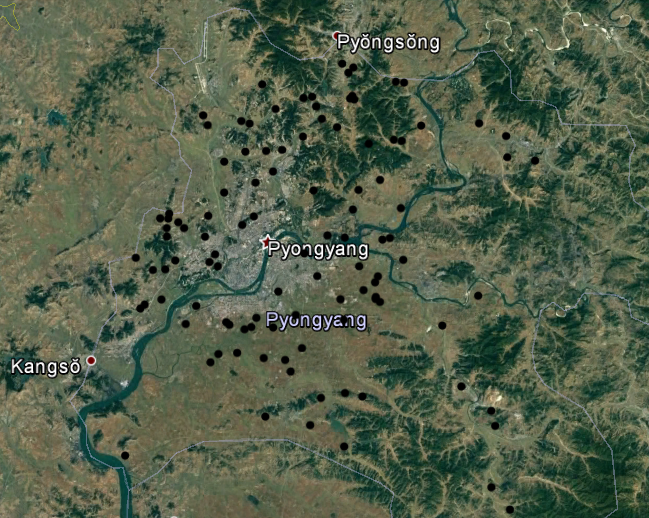
Map showing every monument in North Korea. Click for larger view (opens in new window).

[Note: the download link to the 2017 map has been removed as the 2021 version was made available.]

Below is a breakdown of the number of items per province and other main folders. As soon as I can I will also add some graphics showing how many of each item there are (like the fact there's active 1,539 anti-aircraft artillery batteries).


Phase II Complete Item Counts - March 5, 2017

Chagang Province = 2,695
   Military: 162
   Monument: 544 markers rep. 585 monuments
   Domestic: 1,989

Kangwon Province = 4,443
   Military: 1,131
   Monument: 762 markers rep. 928 monuments
   Domestic: 2,550

N. Hamgyong Province = 4,690
   Military: 450
   Monument: 765 markers rep. 796 monuments
   Domestic: 3,475

S. Hamgyong Province = 6,300
   Military: 627
   Monument: 1,053 markers rep. 1,154 monuments
   Domestic: 4,620

N. Hwanghae Province = 5,833
   Military: 1,347
   Monument: 946 markers rep. 1,100 monuments
   Domestic: 3,540

S. Hwanghae Province = 6,304
   Military: 1,008
   Monument: 1,054 markers rep. 1,146 monuments
   Domestic: 4,242

N. Pyongan Province = 5,581
   Military: 716
   Monument: 1,049 markers rep. 1,145 monuments
   Domestic: 3,816

S. Pyongan Province = 7,002
   Military: 1,134
   Monument: 1,205 markers rep. 1,325 monuments
   Domestic: 4,663

Pyongyang District = 6,150
   Military: 1,129
   Monument: 1,049 markers rep. 1,230 monuments
   Water supply: 290
   Domestic: 3,682

Rason District = 531
   Military: 42
   Monument: 94 markers rep. 99 monuments
   Domestic: 395

Ryanggang Province = 2,183 total
   Military: 95
   Monument: 338 markers rep. 371 monuments
   Domestic: 1,626
   Mt. Paektu: 126 - inc. 2 duplicates not inc. in counts elsewhere

DMZ-area Road Blocks: 198
DMZ: 1,401 + 394 miles of fence
Tall Mountains: 245
Airports: 127 (108 runways and 19 waypoints)
UN Joint Security Area: 5
Border Crossings: 24
Large intersections: 10


**********Grand Totals**********
Grand Total: 53,722 markers
   Military: 8,201 + DMZ/RBs/Airports = 9,567
   Monuments: 8,859 markers representing 9,879 monuments
   Domestic (inc. Border/Intersections/Mts) = 35,296


NOTE: AccessDPRK maps, articles, or other creations may not be used for commercial purposes without the express authorization of Jacob Bogle.


--Jacob Bogle, 3/5/17
www.JacobBogle.com
Facebook.com/JacobBogle
Twitter.com/JacobBogle

Friday, January 27, 2017

What's The Point?

I have been talking about North Korea and mapping the country for over four years now, and a question people ask me fairly often is, 'what's the point?' My normal answers tend to revolve around my own inherent interest in the country and in mapping, however, there is a far more concrete value to this endeavor than simply satiating my curiosity.

North Korea is more than just some rouge state hellbent on gaining nuclear weapons. It's a dynamic country with 25 million people, all of whom share a 2,100 year history with 50 million of their southern brethren. And, yes, they also have a deep military state that is always seeking ways to hide their more dangerous activities. And because of all of this, things change - and much remains unknown. Current collections of nation-wide data are years out of date and resources like Google Maps are often woefully inadequate.

Because their military activities tend to get the outside world to pay attention more than anything, I think the best example of the benefits of the #AccessDPRK Mapping Project is to show how some of these military areas have drastically changed over the last decade.

This image shows each of the 318 active anti-aircraft artillery batteries in Pyongyang.


And this shows each of the 108 decommissioned artillery batteries in the area.


Because of the reliance on older maps and information, just about every crowd-sourced mapping site (Wikimapia, Openstreet, etc) has these inactive places marked. Several of them have been completely demolished and turned into farm land but exists on maps as artillery sites!

It's not just Pyongyang. I have located 386 decommissioned artillery sites all over North Korea, many of them, unfortunately, are on maps. Furthermore, of the 1,358 known active sites, some 500 aren't on any map.

On the domestic side, hundreds of additional dams and hydroelectric power stations can be accounted for. Here are some in Chagang Province:


And speaking of the shared history of Korea, #AccessDPRK now has 346 ancient sites mapped - an increase of 119 new places found since my article on the subject back in February 2016. As far as I have been able to find, at least half of these sites aren't on any maps available online (or anywhere else that I can find). This doesn't include hundreds of centuries old burial mounds and tombs either.


Furthermore, the project will also allow people to see some of the tremendous natural changes that have occurred, like an enormous landslide in the ecologically important Mt. Chilbo National Park, or the damage done in recent flooding.

It would be difficult to detail every value of a map with over 50,000 places marked, but I hope I've adequately expressed the point of this effort.


--Jacob Bogle 1/27/17

Thursday, January 12, 2017

Activity Spotted at Possible Nuclear Site

There's a massive underground complex hidden away in the hills of North Korea. For years it has laid dormant (as far as one can tell), that is until recently. The facility at Hagap (40° 04′ 48″ N, 126° 10′ 56″ E), is a suspected underground nuclear site, either to store material or produce it.

According to Dr. Jeffery Lewis, at Armscontrolwonk.com, the site became publicly known in 1998 (the US government knew about it since 1996) and was constructed at the same time as another underground site, Kumchangni (40° 7' 8 "N 125° 8' 32"E). Since such a site could possibly violate the bilateral 1994 Agreed Framework, North Korea didn't say a word about the place. After the site became public, the US managed to send a delegation to visit it. They didn't find much besides an oddly designed underground facility.

The debate about what exactly is going on at Hagap continues to this day. It has been speculated that the site is used for nuclear materials storage, centrifuge production, or even just a large secure warehouse for archival materials. However, the connection with Kumchangni still remains. There is a third site too, at Yeongjeo-ri (Ryanggang Province), but little is known about it.

North Korea's nuclear program has been ramping up since the final days of Kim Jong-il, and Kim Jong Un seems to be increasing that pace. In the light of that, it is disconcerting to see fairly substantial new activity happening at Hagap.

(Click image for larger view.)

At the site you can see a large mound of new rock debris which has been piled up in the pond below the main entrance. You can also see an increase in the number of small buildings and debris that are in the small valley.

Here are some closeup images:

This one shows the debris mound.

This image shows the extended activity area with new buildings.

There is also an odd collection of towers nearby. They look like electrical transmission pylons, but are clustered together into three groups. There are no visible power lines either. It's possible these were laid out when Hagap was originally constructed to provide power, but haven't been needed since the site was largely abandoned. Or they could be some kind of radar/communication array. The towers are located around a bend in a river with small hills on either side, those hills have an anti-aircraft artillery battery stationed on each one. If you'd like to study the area further, it can be found here  40° 4' 50"N 126° 6' 35"E.


--Jacob Bogle, 1/12/2016
JacobBogle.com
Facebook.com/JacobBogle
Twitter.com/JacobBogle

Friday, January 6, 2017

New launching/landing sites constructed?

UPDATE: These have been confirmed as emergency parking positions for jets, since highways can be used as auxiliary airfields (and North Korea does have at least 14 official "emergency highway strips").


On the heels of Kim Jong-un suggesting that the country is very close to testing another ICBM, I've discovered three sites that could be used as dedicated mobile-missile-launcher pads.

These sites were constructed in 2016 and have the same general design.

The first and largest is near Kaesong and lies less than 10 miles (16 km) from the Demilitarized Zone with South Korea.

Located adjacent to the Pyongyang-Kaesong Highway, by the village of Haeson-ri, this site was under construction in March and had been completed by October 2016.

Each pad is 45 feet (14 meters) wide and the straight portion is 175 feet (53 meters) long. The area around it also contains numerous bunkers and tunnels.

The second site is in Pyongsong, South Pyongan Province, which is 21 miles (34 km) north-northeast of the center of Pyongyang.


Just like the Kaesong site, this one is located adjacent to a main highway. In this case, National Highway 65. The area also has a high concentration of HARTS (Hardened ARTillery Sites), which are marked by the red dots. Several additional military facilities are also nearby.


Lastly, the third site is similar in its size and the fact it's right off a highway, but its design is different. The primary difference is a lack of a central berm. This site is located near Sukchon, also on South Pyongan.


If these are indeed dedicated pads for launching missiles, it would be in line with North Korea's continued modernization and expansion of their offensive capabilities.

________________________________________________________________________________________
I'd like to make a quick note about the #AccessDPRK Mapping Project. Across North Korea, I have located 9,500 military related places. I have finished the primary mapping process and am now working on incorporating the work of two others into a main and comprehensive single file. After that, the entire body of work will be published.

--Jacob Bogle 1/6/2017
www.JacobBogle.com
Facebook.com/JacobBogle
Twitter.com/JacobBogle

Friday, December 2, 2016

Over Half Million Affected by Floods

Flooding during monsoon season is an annual problem for North Korea, especially given its mountainous terrain and poor land management practices. Heavy flooding in August is said to have affected some 600,000 people according to North Korea's Red Cross Society. Urgent aid was needed as winter comes early and harsh, particularly for those in northern areas (which also tend to receive less government attention and assistance in general).

Map of Tumen River.

The primary river in the northeast of the country is the Tumen, which flows from Mt. Paektu and forms part the DPRK-China border and near it's mouth, the DPRK-Russia border. The river drains some 5,000 square miles (13,000 sq. km) of rugged and mountainous areas of North Korea.

According to the Korean Central News Agency, reconstruction has now finished in Hoeryong, North Hamgyong Province, including a new kilometer-long dike to protect against further flooding of the Tumen.

Here are some satellite images of the flood damage along the river, including the cities of Hoeryong and Musan. The occassional curvy and thin yellow line is the map border between North Korea and China. Simply click on any picture and you'll be able to see larger versions.

This is a before and after image showing flooding behind the old Tumen River Dike. It shows a new river channel and destroyed buildings.


Here is a picture of one of several portions of road that was washed out along a tributary to the Tumen in the Hoeryong region.

The next two pictures give a before and after view of a Hoeryong neighborhood that was completely destroyed by the floods.


Nearby is the only non-rail bridge that connects that neighborhood to the rest of the city. The flood took out a section of it.

Moving up river, toward Musan, there's a section that shows distinct flood damage. You can see debris and mud built up in the river bed, discoloration of the land where crops were destroyed, and a road that was "smeared" out as the Tumen overflowed its banks.

Here is a small village that was almost completely erased.
Before the flood:

After:

In Musan, the destruction wasn't limited to just a flooded river. Musan is a key mining city and sits in a series of vallies with steep hills and mountains surrounding it, there's a tributary river running through it and then, lastly, the Tumen cuts off the western side.

Here you can see buildings destroyed by the Tumen.

And here are homes that were buried in mud and rocks as otherwise dry ephemeral mountain streams turned into raging torrents.


Finally, the Hoeryong border crossing facility was also severely damaged. At least two of the buildings suffered major damage and the land around the facility was wrecked. In the satellite image you can also see some of the construction equipment as the government tries to clear the area and make repairs.


--JacobBogle, 12/2/2016
www.JacobBogle.com
Facebook.com/JacobBogle
Twitter.com/JacobBogle - Use the hashtag #AccessDPRK to join the conversation!

Wednesday, September 7, 2016

New Missile Test & Mapping Update

With Phase I having been published around 6 months ago and the recent mid-range ballistic missile test on Sept. 5, I figured I should give an update on where Phase II stands.

I'd like to quickly touch on the missile tests. According to CNN, the tests were carried out in Hwangju County, North Hwanghae Province (25 miles south of Pyongyang center). Korean Central Television released a YouTube video of the missiles being fired. In the video, you can see that the missiles were fired from mobile launchers positioned on a major highway with a highway tunnel in the background. In another scene a cell or radio tower is also visible.


Given the positioning of the camera, it's difficult to really gauge how far away the tunnel is from the launchers, however you can see a "turn around" spot near the tunnel and a bit farther back toward the launchers, you can see a section of pavement that looks a bit darker than the rest. This is typical of bridges. There's only one highway section that features all of these things near Hwangju.


So, this stretch of highway would seem to be the most likely location of the tests. Hwangju is also the home of the Third Air Combat Command which is responsible for the defense of the DMZ and southern portions of the country, which means they would have access to ballistic missiles. Additionally (whether or not these missiles came from here), the hills around Hwangju are filled with tunnels, hardened artillery sites, military units, and military storage facilities. That said, I cant't find any section of highway in the entire province that seems to look exactly like the video footage.

Mapping Update

As I mentioned in the Phase I release post, Phase II (which I'm working on now) will include a map of all the schools, town halls, "Palace's of Culture" (Juche study halls), and other buildings of interest in the country. I started mapping these places part-way into Phase I, meaning that I had to go over the rest of the country another time to get all the sites I hadn't originally marked.

The blue dots cover all the areas I have had to re-map (which adds up to roughly half of the country). In addition, I decided to go over Pyongyang entirely for a second time because of how dense the city is. My goal in all of this is to not miss greater than 10% of any given type of item (cell towers, schools etc) nationwide.


The Google Earth file size for Phase I is 2.7 MB and contains over 28,000 places. The current Phase II file adds a further megabyte, and I'm not even finished working on it! The file for Pyongyang itself has nearly doubled in size.

To help make the project of greater use to people, I have been scouring different sources for additional information on the various sites I've marked. If the name of a school is known, I want that placemark to be given the school's name. If a fancy looking new building pops up, I want to be able to tell you what it is, and so forth. Since I began this project over 3 years ago, I have also gone back through some of the folders and updated them, better categorized some places (particularly military sites), and worked to make everything uniform in terms of descriptions and the icons used.

The work for Phase II really comprises two parts: the first part is all the new mapping I'm doing, the second part is taking Curtis Melvin's North Korea Uncovered file (which is now over 7 years old) and updating any changes that have happened to the 8,100 sites he mapped. This also includes making corrections to places that were incorrectly identified (there aren't many, but accuracy is important) as well as fixing a problem created by Google Earth itself.

When Google Earth has updated imagery added, sometimes the coordinates don't mesh perfectly and, particularly in South Hwanghae Province, around 2006 the coordinate system was adjusted. The practical meaning is that many of the places marked there by Curtis are now off by as much as 1,000 feet. So I need to go through all of them and move them to their "corrected" positions. Oh, and I have to do the same for the large military-focused file created by Google Earth user "Planeman_"  and then collate his and Melvin's files because each project, while largely covering the same places, did map out some spots the other person missed. All of this adds up to a mountain of work.

The work of Phase I was completed in Nov. 2015 and released in March 2016. Since then, I have been able to go over nearly all the places I needed to. I only have about 20% of Pyongyang left. I have also already gone through thousands of sites marked by Melvin and Planeman_, though there is still much work remaining on that front. Some of the cool things that my comprehensive map will be able to bring to the general public is: 24 surface-to-air missile sites previously un-mapped by the earlier projects, the entire network of cell towers (very few existed during the time Melvin was working on his project), an updated map of their missile testing sites, more detailed maps of various palaces, a much more detailed map of Pyongyang with hundreds of buildings marked, and lots of added bits of information on countless other sites (including nuclear facilities).

I have a two week international vacation coming up soon and then of course the holidays are getting closer and closer, but I am really hoping to be able to have my Phase II mapping completed, the corrections/updates made to North Korea Uncovered, and the combining of Phase II, NKU, and Planeman_'s projects into a single master file with no duplicates and as few holes as possible by the end of 2016, if not sooner.

I'd like to thank everyone for their continuing support and patience. This has turned into a major project that has required thousands of hours of work and research. I hope it will be useful and live up to expectations once completed.

--Jacob Bogle, 9/7/2016
www.JacobBogle.com
Facebook.com/JacobBogle
Twitter.com/JacobBogle

Sunday, March 13, 2016

Urban Combat Training Centers

North Korea has one of the largest conventional standing armies in the world, but much of its equipment is outdated and would be woefully inadequate against a direct force-to-force conflict with South Korea and the US. However, its 1.2 million person military isn't just made up of regular soldiers.

Outside of the nuclear threat, the one area that has many military analysts concerned, is North Korea's asymmetric warfare capability. The country's Special Operations Force has around 180,000 troops that are highly trained, motivated, and specialize in infiltration, terrorism, urban combat, and other methods. There are four known urban combat training centers in North Korea, with an alleged fifth underground site somewhere around Pyongyang. On top of the urban combat sites, there's a further 23 large military training grounds. SOF training lasts 3-6 months and covers a very wide range of tactics.


While the exact date the SOF was formed isn't known, it is clear they've been active since at least the 1960s. Between 1953 and 1999, the DPRK committed over 76,000 transgressions against the 1953 Armistice Treaty. Among those, we know that the SOF was used in the 1968 Blue House raid which was an unsuccessful assassination attempt on South Korea's then president Park Chung-hee and resulted in 30 ROK-US fatalities as well as the suicide of 29 of the North Korean operatives. There was also the 1983 Rangoon bombing in Burma (another assassination attempt) that resulted in 67 casualties.

Here's the coordinates to the four training centers:
N. Hamgyong Province:  38°24'2.01"N   126°22'14.29"E
N. Pyongan Province:  40° 0'46.89"N   125°53'8.94"E
Pyongyang-Kangdong: 39° 4'50.13"N   126° 5'33.99"E
Pyongyang South:  38°58'1.08"N   126° 6'20.62"E

The largest of the urban combat centers is located 16 miles north-east of the Yongbyon nuclear site in North Pyongan Province. It has a full-scale downtown mock-up that's half a mile wide on each side.

Here's a section of the "town" with the buildings arranged in rectangles.


Pyongyang has two known urban warfare centers. Both of them are to the far east of the city center and are 8 miles apart (nearly in a straight north-south line). The southern base has buildings of a slightly more modern design, while the northern one is more traditional.

The southern site:


The northern one is near the town of Kangdong, Pyongyang, known as Soe-gol.


There is also an alleged site in Pyongyang which is mentioned in Bradley Martin's book "Under the Care of the Fatherly Leader", and is described by defector Ahn Myung-jin as being underground near the country's primary espionage training complex and is supposedly dedicated to training spies and other special forces to infiltrate & attack Seoul. It has 8 kilometers of tunnels and is an exact small-scale replica, outfitted with operational stores, residences, government buildings, and even allows them to "buy" things in the stores so they can get used to the way of life in South Korea - before attempting to destroy the city. There are many underground facilities and tunnels in Pyongyang, but I haven't been able to find likely locations for such a compound.

For a bit of international context, here is an urban combat facility in Fort Bragg, NC USA.


For some more information on North Korea's Special Operations Force, you can read the report "Countering North Korean Special Purpose Forces" by Australia's Air Command and Staff College. (PDF link)

There's also the book "North Korean Special Forces" by Joseph S. Bermudez. (link to Amazon)


--Jacob Bogle, 3/13/2016
www.JacobBogle.com
Facebook.com/JacobBogle
Twitter.com/JacobBogle