Statue of Kim Il Sung and Kim Jong Il riding horses. Erected in 2012 after the death of Kim Jong Il.
For the uninitiated,
Juche is the official state ideology of North Korea. It is most commonly translated as "self-reliance". This self-reliance is supposed to mean the self-sufficiency of the state and that "man is the master of the revolution". In reality, neither of these is true. The general concept of Juche has a history that goes back to the 1930s, however, it wasn't until 1982 that Kim Il Sung wrote the main treatise on the subject. Mixing Korean ethnic nationalism with Marxism-Leninism, Juche also helps to support the Kim family personality cult, which is further backed up by the
Monolithic Ideology System, which declares that there is no correct thought but the thought of Kim Il Sung, Kim Jong Il, and (now) Kim Jong Un. Through it all, the web of Juche underpins the fabric of North Korea's political and cultural systems.
The
cult of personality that exists within North Korea is the most extreme and pervasive example that has ever existed. With a genesis that dates to the very foundation of the country, North Korea is strewn with
thousands of monuments praising and commemorating the leadership. Its people are taught songs of praise to the Kim family, and important sites have become pilgrimage destinations for millions (as well as mandatory tourist sites).
Christianity has Rome. Judaism has Jerusalem. Islam has Mecca and Medina. The Cult of Kim has Mangyongdae, Pyongyang, Hoeryong, Mt. Paektu, and Myohyangsan.
There are countless historic and revolutionary sites within North Korea, but those core locations provide the major, real-world backbone needed for the cult, and also helps to support its racialist overtones as the people of Korea are viewed within the cult as the "purest" race in the world, with the purest bloodline leading the revolution. In this article, I want to take a look at the major sites that anchor this Juche republic.
Locations of sites mentioned in the article. Image source: Google Earth/AccessDPRK)
Mt. Paektu
Kim Jong Un's 2012 visit to the summit of Mt. Paektu. Frozen Lake Chol is in the background. (Image source: KCNA)
Located in the far north of the country, split in two by the borders of China and North Korea, the ancient volcano
Mt. Paektu (9,003 ft) holds a special spiritual place in the hearts of all Koreans, north and south. The mountain really is a wonderful place and it is the highest mountain on the Korean peninsula. Lower elevations are covered with dense forests and countless wild animals roam. Higher up, the rich land turns to ice and rock, finally giving way to the enormous crater lake (Lake Chol/Heaven Lake) at the summit, which was formed by an extremely powerful
eruption around 946 AD.
From this majestic setting, the foundation myth of the Korean people arises. The god-king Dangun is said to have been born on the mountain to his mother, the daughter of a bear and a human, and to his father, the son of the Lord of Heaven. Dangun eventually went on to found what has become known as Korea (Old Joseon) in 2333 BC. This date is celebrated in both Koreas as National Foundation Day, and for over 4,000 years, the people of Korea forged a unique and ever unified identity that was only later shattered by the events of World War II and the Korean War.
The mountain's military role also lends itself to the mytho-historical accounts of Kim Il Sung and his band of guerrilla fighters. Mt. Paektu and its geologic offspring, the lower mountains that run down the spine of the country, served as an important historical defensive line. It enabled the construction of many forts and walled cities that helped to defend Korea from invading Chinese, roving bandits, and other outside threats. Kim Il Sung's story here begins with his struggle against Japanese occupation. From the flanks of the mountain he, with his iron-will and band of peerless, peasant worriers, would strike Japanese strongholds, disrupt communication and transportation, liberate towns, and raise an army that eventually defeated the whole of Imperil Japan. The mountain gave them shelter and supplies. It taught them lessons through struggle that made them stronger and wiser. And as the Japanese threat vanished from the Earth, yet while Western imperialism threatened to devour all, it gave him a son: Kim Jong Il.

The alleged birthplace of Kim Jong Il at the Mt. Paektu "Secret Camp". (Image source:
NK News)
The reality is that Kim Il Sung and his fighters never held more than a moderate-sized village for more than a few hours. Their military threats and ideological assaults on imperialism were never more than an annoyance to the Japanese. But after decades of spin and embellishment, Kim Il Sung, with the divine mandate of Mt. Paektu, all but single-handedly defeated the Japanese, overthrew the old capitalist order by awakening the call to class struggle in the hearts of the people, and eventually created the most powerful nation in the world after defeating the former most powerful, the United States.
Likewise, Kim Jong Il (who was actually born in Russia, not on Mt. Paektu), used the mystical nature of the mountain to legitimize his rule. Not only was he the son of Korea, he was the son of Heaven. He was part of a spiritual lineage that dates all the way back to Dangun and the founding of Korea. No true Korean could question him.
It is that lineage that, using the broad scope of Juche, enables the regime to suppress minorities, exile the physical and mentally handicapped, and look upon all other races as inferior beings. To them, only Koreans are pure of blood and heart, and that must be defended at all costs by the Paektu Bloodline, the noblest bloodline that ever was.
Soldiers making their pilgrimage to the mountain. (Image source:
Commons/Liaka ac/CC 2.0)
As such an important place, numerous songs and poems have been written about the mountain, and it features in national symbolism, like the National Emblem. The pine tree is even the national tree of the DPRK because of its association with Mt. Paektu and Kim Il Sung's activities there during the Japanese occupation.
The nearby city of Samjiyon has been turned into the main stop before visiting the mountain itself. It has multiple monuments, walled of villas, and a secure palace for the ruling Kim. Since 2005, the city has undergone a series of upgrades and it is the intention of Kim Jong Un to turn it into major regional hub by 2020. After all, Samjiyon is the "spiritual hometown of the people" according to government propaganda.
The Samjiyon Grand Monument (Image source:
Commons/Liaka ac/CC 2.0)
Myohyangsan as seen from Pohyonsa Temple. (Image source: Commons/Uri Tours/CC 2.0)
Myohyangsan (which translates to "
mysterious fragrant mountain") is a mountain along the border between North Pyongan and Chagang provinces. The mountain was the home of the mythical King Dangun after he descended from Mt. Paektu and began to establish Korea. Myohyangsan is another beautiful mountain and has been recognized by UNESCO as a world biosphere reserve for its many endemic and endangered plant and animal species. The mountain is also dotted with century's old temples, graves, and other historic ruins, which tie its current modern use to the past.
Nestled in the valley are a set of two large underground museums called the International Friendship Exhibition. These museums hold over 200,000 gifts to Kim Il Sung and Kim Jong Il from people around world.
Satellite imagery from 2017 suggests that the museums are undergoing expansion, perhaps to include new gifts being received by Kim Jong Un. Unfortunately, photography inside the exhibition is prohibited, so I can't show you what it looks like indoors.
One of the museum entrances. (Image source:
Commons/Uwe Brodrecht/CC 2.0)
The associated city of Hyangsan (Kuwollim), largely built in traditional Korean architecture, serves as the urban center that helps support the several luxury hotels pilgrims stay at. The existence of these museums (rather, the fact so many gifts have been bestowed on the leadership) is used by the government to prove the supremacy of the Kim family. Countless honorary degrees from questionable universities of the Communist era, an array of now meaningless awards and medals from defunct Eastern bloc countries and former African despots, and all manner of other things from the simple to the magnificent are all to be found here. Citizens (and tourists) are walked through dozens and dozens of rooms being told who, when, and where each item came to Kim Il Sung or Kim Jong Il. The site is used to show how the gifts demonstrate that the ideology created by the Kims is correct and is allegedly seen as important worldwide. The exhibition also helps to instill a sense of community, that North Korea really isn't all alone; rather, it is just the evil capitalists who are trying to destroy the country and to harm "true" freedom loving people around the world. But thanks to the Kims and their tireless work, all people can rest assured in the ultimate victory that is to come - and these items prove it.

The recent activity at the museum is also part of an overall improvement of the area. The construction of a new airport and renovated facilities have all occurred under Kim Jong Un. He has spent millions around the country improving the major sites associated with his family and the government.
Located nearby is the curious Hagap Facility. Once thought to be an underground nuclear complex, it is now thought by many to be a massive underground repository for the works of the Kims and other important national archives. It, too, has ongoing new construction activities.
Pyongyang and Mangyongdae
The site rich capital of Pyongyang. Click for larger view. (Image source: GoogleEarth/AccessDPRK)
Pyongyang is the central focus of the cult of Kim and from where Juche emanates. It is the birthplace of Kim Il Sung (in the Mangyongdae neighborhood) and it is the center of government. While residency in the capital is tightly restricted, all North Koreans are expected to make the journey to visit the main sights. These include, the Juche Tower, the premier Tower of Immortality, the birthplace of Kim Il Sung, his eternal resting place (along with that of his son, Kim Jong Il) at the
Kumsusan Palace of the Sun, the monument to the foundation of the Korean Workers' Party, the Revolutionary Martyrs' Cemetery, and all must bow before the enormous bronze statues at Mansu Hill.
Juche Tower at night. (Image source:
Commons/Martyn Williams/CC 2.5)
As briefly discussed earlier, Juche is the guiding light of North Korea. Kim Il Sung's explanation of Juche was, "
Establishing juche means, in a nutshell, being the master of revolution and reconstruction in one’s own country. This means holding fast to an independent position, rejecting dependence on others, using one’s own brains, believing in one’s own strength, displaying the revolutionary spirit of self-reliance, and thus solving one’s own problems for oneself on one’s own responsibility under all circumstances." Unfortunately, this notionally positive concept was never meant to empower individualism.
To honor the invention of the Juche idea and to honor Kim Il Sung's 70th birthday, the Juche Tower was opened in 1982. Standing at 560 feet, the tower contains 25,550 blocks - one for each day of Kim Il Sung's life to that point. The tower is one of the most iconic and popular sights in Pyongyang and, from the top, is the best place to take panoramic photos of the city. The tower serves as a iconographic focal point for the city (as it can be seen across the Taedong River from Kim Il Sing Square) and is the backdrop for parades and mass celebrations.
To underscore the importance and claimed universality of the Juche idea, the tower also contains 82 "friendship plaques" from supportive organizations across the world.
Kim Il Sung's birthplace. (Image source:
Commons/stephan/CC 2.0)
The birthplace of Kim Il Sung at Mangyongdae carries with it the same importance and sense of awe as Bethlehem does for Christians. Mangyongdae was once a very rural community on the outskirts of Pyongyang, but now that it contains the claimed original birthplace of a demigod, it is a major tourist attraction and has become infused with both a religious and recreational nature.
This
Revolutionary Site has been a place of pilgrimage since 1947. Kim Il Sung's childhood 1,000 ri (~300 mile) "Journey of Learning" and his other youthful exploits took off from this spot. The site contains not just the house, which is surrounded by green and wooded spaces, but it has been expanded with modern facilities such as the Mangyongdae Revolutionary Museum, a large amusement park, a water park, and is adjacent to the Mangyongdae School where North Korea's next generation of elites are taught. The amusement park can technically accommodate 100,000 people a day, which attests to the area's importance.
The house is treated with reverence and as a place of reflection, while the outer areas of parks provide the people with joy and an ability to somewhat let go of their otherwise ridged daily lives. Through the outlook of a North Korean, all of this is provided to them thanks to the love and caring of their eternal father and a gracious state.
Kumsusan Memorial Palace (2010). (Image source:
Commons/David Stanley/CC 2.0)
As is even the case demigods, death tends to follow life. Kumsusan began as a palatial residence and office for Kim Il Sung and was constructed in 1976. Following his death in 1994, it was converted into a mausoleum. Kim Il Sung, still officially the Eternal President, lies in a glass sarcophagus at the heart of the palace. When his holy son, Kim Jong Il, died in 2011, he, too, was placed within the Kumsusan Palace of the Sun. The original construction of the 115,000 square feet palace and the subsequent renovations needed to turn it into an everlasting mausoleum have been reported to have cost a combined $900 million.
Statues of Kim Il Sung and Kim Jong Il within the palace. (Image source: KCNA)
Visitors are required to pay their respects to the lifelike statues of the gone but not forgotten leaders. The current statues replaced pure white marble ones in 2016.
The reopening of Ryomyong Street with the renovated tower in the center. (Image source: KCTV)
To underscore the fact that Kim Il Sung never truly left the people, thousands of "towers of immortality" were constructed across the country. These local towers are gathering places for holidays, mass celebrations, weddings, etc. People are required to bow as they walk passed them and maintenance of them is of the highest priority. In fact, the towers, as well as major murals and other key monuments, are often the only places that have 24/7 electricity provided and nighttime lighting. Your home may be cold and dark, but you can warm yourself by the glow of the tower.
The preeminent 92-meter (301 feet) tall tower in Pyongyang was renovated in 2017.
Monument to the Foundation of the Workers' Party of Korea. (Image source:
Commons/Bjørn Christian Tørrissen/CC 3.0)
No trip to Pyongyang is complete without a visit to the Workers' Party of Korea Foundation Monument. The
WPK was founded in 1949 and serves as the only real political voice in the country. While it is in reality little more than a rubber-stamp body for approving "laws" dictated from on high, the legal system, political activities, education, correct culture and thought, and nearly every other aspect of one's daily life is ultimately controlled by the Party. To be a Party member is to have an easy life and a future for your children. To be denied membership, or worse, ejected, is cast a multi-generational shadow on your family from which they may never recover. Obedience to the KWP is the primary function of every North Korean.
The monument was erected to mark the 50th anniversary of the Party's founding. The granite and bronze monument is in the shape of the WPK's emblem; a hammer (workers), sickle (farmers), and calligraphy brush (intellectuals). It lies on the right bank of the Taedong River, across from the Korean Revolution Museum on the left bank. These, in turn, lie upstream from Kim Il Sung Square and the Juche Tower. These form two axis that ties the city together based on the Kim family and the Party.
A view of the graves and busts at the Revolutionary Martys' Cemetery. (Image source:
Commons/Nicor/ CC 3.0)
The Revolutionary Martys' Cemetery is the primary cemetery for the leading revolutionaries in the fight against the Japanese. Located near the top of Mount Taeson (which also holds the ruins of an ancient fortress), the cemetery contains the graves of 159 elite figures. It was first established in 1975, but later expanded in 1985. Among the internees are the mothers of Kim Il Sung and Kim Jong Il.
Kim Il Sung created his power base around those guerrilla fighters. They helped lend him legitimacy in terms of his military prowess and helped him consolidate power during the early years of the government when multiple factions still existed. Those that are buried here served as steady rocks from which Juche and the Monolithic Ideology System could be established and flourish.
Mansu Hill Grand Monument. (Image source: Commons/Bjørn Christian Tørrissen/CC 3.0)
The Mansu Hill (Mansudae) Grand Monument is perhaps the most well-known monument in North Korea as it is required to pay homage there for anyone coming to the capital. The towering 66-foot bronze statues of Kim Il Sung and Kim Jong Il greet pilgrims with a smile. Everyone who visits is required to bow before the statues and present a small bouquet of flowers. Despite their friendly appearance, the bronzed Kims look on with absolute confidence and power; their scale dwarfing even large groups of people, forcing them to submit. In front of the statues, flanking either side of the square, are two massive Red Flag monuments that remind the visitor that they are in the Juche republic, and that having the correct ideology is the most important thing.
Behind the statues is a massive mural of Mt. Paektu that is painted on the wall of the Korean Revolution Museum - another important location to see for any able citizen. The museum was already one of the largest buildings in the world when it was first constructed, but it underwent further expansion and remodeling between 2016 and 2017. The museum underscores the North Korean version of events of the Japanese occupation (which lasted from 1910 to 1945), as well as tells an atypical history of Korea from 1860 through to today. As with all museums in the country, it recounts history through the lens of the lives and philosophy of Kim Il Sung, Kim Jong Il, and other major figures.
The fact that North Korea contains the spiritual heart of Korea (Mt. Paektu), Korea's political creation (Myohyangsan), and one of the ancient capitals of Korea (Pyongyang), allows the regime to play up their claim to having the ultimate, nearly divine right to rule over all 75 million Koreans living both north and south. This mindset buttresses the North's longstanding drive to reunify the peninsula under the single rule of the Kim family.
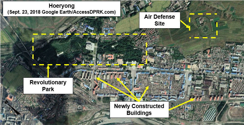
Hoeryong
Kim Jong Suk in her youth. (Image source:
Commons)
Located in the distant northern reaches of the country, Hoeryong is the birthplace of Kim Jong Suk (born Dec. 24, 1917), Kim Jong Il's mother and the grandmother of Kim Jong Un. She died in 1949 as a former guerrilla fighter. Since then, her legacy has become one of being an acclaimed and immortal revolutionary and model mother. She was granted entrance into the noble pantheon of the Three Generals: Kim Il Sung, Kim Jong Il, and herself. As the "Mother of Korea" her life and places associated with her life feature within the Kim family cult and makes her the most prominent woman in North Korea's version of history.
Kim Jong Un has spent part of his rule solidifying his own place within the cult, and that means boosting the cults around those he is directly related to to give himself greater legitimacy, as he is still young and is not the firstborn - both of which are important matters within Confucianism. Hoeryong has had monuments and museums for decades, but now the city is largely being rebuilt and the revolutionary sites and history associated with his grandmother are being burnished.
The park area dedicated to the life and times of Kim Jong Suk covers approximately 35 hectares (86 acres).
Here is Kim Jong Suk's birthplace. A modest, traditional-style peasant's home.
(Image source:
Commons/Ray Cunningham/CC 3.0)
The Museum of the Revolutionary Activities of Kim Jong Suk.
Kim Jong Suk has additional monuments and murals around the country as well. She is included in the International Friendship Exhibition and her grave is at the Revolutionary Martyrs Cemetery in Pyongyang.
(Image source:
Commons/Nicor/CC 3.0)
, AccessDPRK, July 2017
--Jacob Bogle, 12/27/2018
www.JacobBogle.com
Facebook.com/JacobBogle
Twitter.com/JacobBogle


.jpg)
.jpg)
.jpg)
.jpg)
.jpg)
.jpg)