Updated Version - May 6, 2016
(Partial map of mines)
North Korea is surprisingly rich in minerals and coal. Mined materials makes up the bulk of trading, and according to various estimates the treasures underneath the ground are worth upwards of
$10 trillion (250 times larger than their current GDP).
There are two types of mine, the large industrial scale mines (like that at the Geomdeok zinc mine and the
Musan iron mine) and then there are the countless smaller mines throughout the country, mostly coal mines, which are largely dug by hand. Due to equipment failures, flooding, lack of spare parts etc. most mines operate far under capacity. Regardless of the difficulties, mining is one of the major economic sources for the country.
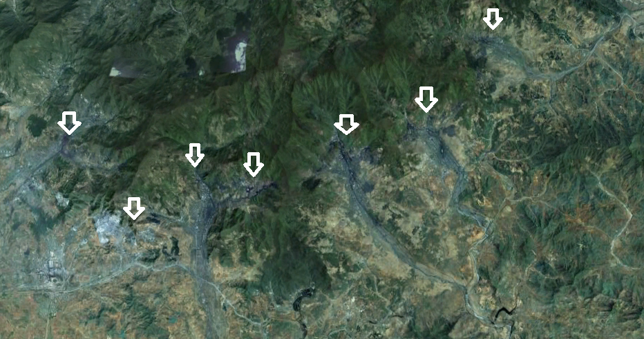
Here is an example of large-scale mining. Located north of Pyongyang, near the city of Sunchon in South Pyongan Province. This image covers an area 17 miles wide and includes multiple mining complexes.
Here is a close-up of one of the secondary mines in this complex
This is one of the larger mines in the area, unlike all the others this one is primarily mining minerals for cement. There are smaller coals mines here as well.
This is a large cement factory.
As with many large-scale industrial regions, military security is always tight. Pukchang Airbase is nearby.
Complete with fighter jets and underground hangers.
As I said, most mines are not massive, they're not mining with million dollar machines or explosives, they're mined by human strength alone, often with hand-fashioned tools. In the
Songbun class system, those in the lowest class or "wavering class" are often assigned the most difficult and dangerous jobs: mining, farming, construction etc. North Korea has one of the worst human-rights records in history, possibly coming in at number one (even over Nazi Germany) when you look at the entire population. Worker's rights aren't really given much thought when it comes to the lower classes (despite the socialist mantras).
Uranium miners for example have a high risk of developing cancers and severe birth defects. Coal miners will suffer from respiratory disease and skeletal problems after years of squatting in small, hand-dug, tunnels and moving tons of rock and coal.
From 2006 to 2010 coal mining has
risen sharply from 23 million tons in 2006 to 41 million tons in 2010. This is in response to the energy crisis facing the country and the need to increase trade to places like China, which is the North's leading trading partner receiving 67% of North Korea's exports.
Here some examples of the more typical small mines.
And finally, this is a mine I found near Yongyon-ni in North Pyongan Province. It shows a side-by-side of the mine in 2006 and in 2010 which shows increased activity. Although the mine is relatively small, in my mind it underscores the country's attempts to secure the nation's energy supply (even if they're not succeeding), an energy supply which is
notoriously lacking.
UPDATE
As I stated earlier, human life isn't the most important thing when it comes to the North Korean government. The country's mining operations
continue to grow, and with it, so do the problems.
You can see small collapsed areas at many of the countries coal mines. With antiquated technology and safety taking a back seat, tunnel collapses are common. Miners are forced to work long hours and that contributes to accidents. Another side of all of this is the fact that mining plays a key role in the country's prison camp and "re-education" system, the workers are then subjected to
incredibly cruel conditions. Additionally, many mining towns have a greater internal security apparatus to ensure the "free people" of North Korea stay inside the mining zone. Check points and road blocks are often added to the usual round of domestic spying and movement controls. This means that residents can neither flee nor demand better conditions.
While continuing my
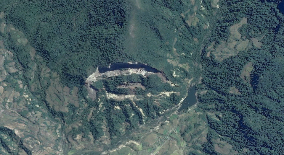
mapping project, I came across a coal mine in the Pyongyang region (approx. 22 miles/35km east of downtown) that got my attention. In 2015, I
documented a kilometer wide landslide in a rural area near Mt. Chilbo National Park. But that was just a natural event after a storm. This new discovery on the other hand, really makes me worried.
The mine, located at 39° 2'39.39"N 126°10'4.89"E, has multiple tunnels that seem to have completely undercut the natural ability of the mountain to support itself. The summit has an elevation (according to Google) of 1,000 feet (305 m), the main part of the mine is located at the southern flank; its summit rises some 350 feet (107 m) above the bulk of the tunnels.
Over the course of 10 years, you can see a dramatic change in the mine.
This first image is from Nov. 16, 2005.
This next image is dated Sept. 5, 2015 and shows some drastic changes. The larger pieces have surface areas as large as 5,000 square feet (464 sq. m) and even 12,000 sq. ft. (1,114 sq. m).
Based on the rate of change, without drastic intervention it is highly likely that there will be a major collapse/landslide that could kill hundreds of people in just a few years. Within the valley beneath this mine lies the city's downtown core and the only road and rail link connecting the city to the rest of the area. A heavy rain could one day unleash hundreds of thousands of tons of rock and earth onto those living below.
Additional reading