Showing posts with label HRNK. Show all posts

Thursday, November 1, 2018

Prison Camp 22 Today

Camp 22 (Kwanliso 22) was a major prison camp within North Korea's extensive prison system. Located in the far north of the country in North Hamgyong Province, it covered some 87 square miles and had the capacity to hold over 20,000 prisoners. In 2012, reporting from the Committee for Human Rights in North Korea and others suggested that the camp had been closed down and its thousands of prisoners either murdered (including by starvation) or transferred to other prison camps.


While the outline of the security fence system remains, the fences and guard towers have all been demolished. As well, during the 2012-2013 time frame, regular domestic buildings were constructed including town administrative buildings, Juche study halls, and monuments. These are items that are largely missing from prison camps but exist in practically every town and village in the country. This strongly suggests that the site has been turned over to civilian use, possibly as a non-penal exile site (as the main roads in and out of the former camp still retain access control points).


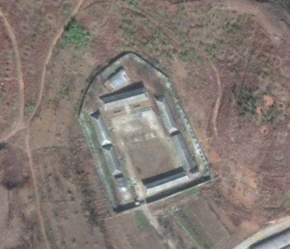
The largest changes to the former camp facilities, besides the removal of fencing and guard posts, seems to be the demolition of two buildings within the camp's administrative center, which includes the torture facility.

Camp administrative center in 2010 with buildings of interest.


Camp administrative center with unidentified building and the torture center demolished as of 2018.


Changes to the villages within the camp attest to its current non-penal nature and shows that something did in fact change in the area's administration after 2012 when all of these changes began to appear.

Raksaeng-ri, a village within the camp as seen in 2011.

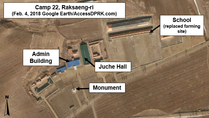
Raksaeng-ri after camp closure. Common civilian buildings have been constructed.


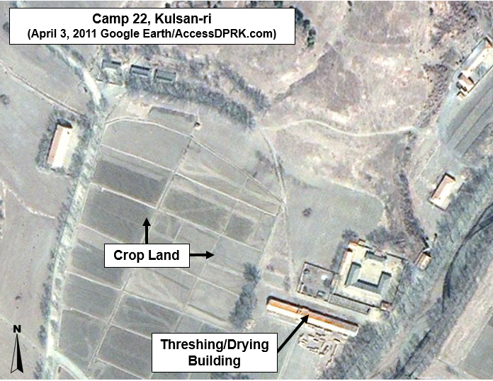
The village of Kulsan-ri in 2011.

Kulsan with a new school and other buildings as of 2018.


Agricultural and mining activities appear to have continued with little interruption since the closure as crops can be seen in various stages of growth and harvest over the years, and trains still visit the mining depot. However, the entrance points to the area are still controlled by check points. All of this leads me to believe that the camp is now being used for either one of two things.

The first is that is could now be a regular agricultural and mining area, however, the government still hasn't fully sanitized the former camp of bodies and other evidence that this was a terrible place and so needs greater control over who gets in and out.
The second is that this is a non-penal location used to send exiles and other non-criminal undesirables. The nearby county of Onsong (which also used to have a prison camp) and the northern reaches of the country in general have long been regions to which the government sent exiles. Pyongyang is regularly purged of "lesser" citizens and there are reports of "abnormal" people (like dwarfs) being rounded up and sent to places out of sight of the capital and visitors. 

There is a third option but it is unlikely, and that is that the camp is still a prison but is being administered in a radically new way.

The main entrance check point as seen in 2016.

It is an unequivocal positive that there is one less prison in North Korea, however the regime seems to show no real interest in doing away with political prison camps or mass internment in general. Prisons like Chongjin, Kaechon, and Chongori have all been expanded in the last decade and repression continues unabated.


--Jacob Bogle 11/1/18
www.JacobBogle.com
Facebook.com/JacobBogle
Twitter.com/JacobBogle

Thursday, November 2, 2017

Is North Korea's Prison System Far Larger than Expected?

By now, nearly everyone in the Western world has heard about North Korea's collection of massive prison camps. There are at least 35 jails and concentration camps in the country (including annexes), all holding around 200,000 prisoners. However, there are estimates that there may be another 10 re-education camps and there are other smaller prisons as well.

Locations of North Korea's main prison camps.

An October 2017 report by The Committee for Human Rights in North Korea (HRNK) titled, The Parallel Gulag, details a system of prisons that operate through the Ministry of People's Security and are called "an-jeon-bu". The report focuses on 22 possible sites. But something that really caught my eye was the design of these sites.

Within the #AccessDPRK Map are hundreds of "compounds". These are generally unspecified groups of buildings or walled-off compounds. I didn't know what they were for certain, but they occurred with such regularity that I felt it was important to map as many as I could. They could be small factories, perhaps barracks or police stations, food distribution centers, or even jails. The places within the "compound" classification vary widely in their configurations, but a good many seemed to follow the same basic design.

In the 2017 report The Parallel Gulag, HRNK discusses a separate, parallel prison system apart from the country's wider known system of massive concentration camps. The report details 20 sites and all share similar design characteristics between each other and the hundreds of other compounds that were mapped as part of #AccessDPRK.

Here are a few satellite images of sites discussed in The Parallel Gulag.


The site above was identified by HRNK as Kyo-hwa-so No. 2 and is located at 39°52'5.88"N 124°44'59.48"E near Tongrim, North Pyongan Province.


The site above was identified by HRNK as Kyo-hwa-so No. 88 and is located at  39°11'58.80"N 127°20'44.93"E between Munchon and Wonsan.


And this site was identified by HRNK as a likely jail in Sangtong-ri (40° 5'35.61"N 127°21'26.26"E) in South Hamgyong Province.

This next set of Google Earth images show a few of the "compounds" that were mapped as part of #AccessDPRK.


This is a site in Kangwon Province and is located at 39°13'41.87"N 127°20'22.79"E


Back in April 2017, I took to Twitter and asked people what they thought these places were. I received several suggestions, but most said they were probably associated with agriculture or food distribution. And we do know that grain warehouses and distribution points are well guarded, which would necessitate walls and guard posts. However, defector testimony has also revealed that during the famine many places were set up as detention centers to handle the huge number of orphaned children. The government simply took over any available buildings it needed and converted them to this use. They were described as little better than prisons in terms of design and security.
If you have no food but need secure buildings, former food distribution centers may have filled the role. Of course, how long the regime continued to use them for this purpose, or if they were changed to serve as another type of detention center isn't known.

With the publication of The Parallel Gulag, we can now definitively say that North Korea's system of concentration and labor camps, prisons, and local detention facilities is much larger than many realized. Considering I knew of so many similar facilities throughout the country, I reached out to North Korea analyst Joseph S. Bermudez (who also aided in the analysis of satellite imagery for the HRNK report). I gave him a few examples of the sites I had mapped, and he gave me his opinion on each one. As with Twitter, he, too, said they were a mix of detention facilities, barracks for local military/paramilitary units, and agricultural related facilities. However, he also said that a lot more study needed to be done.

Map showing the additional sites of interest.

Without further study and defector testimony, we may never know precisely what each of these locations are. However, I have located 632 such sites all over North Korea, which would mean there is a full order of magnitude more of these sites than fully functional hospitals in the whole of the country. With stories of "orphan jails", the now revealed parallel system of jails, the knowledge of historical "black sites" (like The Barn), and the highly secretive nature of the regime, it is safe to bet that at least some of these facilities are previously unknown prisons.

Here is a map of all the sites. If you open it up in Google Maps, you can save it as a KML for Google Earth as well.


If you have any additional information on any of these sites, please let me know!

--Jacob Bogle, 11/2/17 (updated 5/10/2019)
JacobBogle.com
Facebook.com/JacobBogle
Twitter.com/JacobBogle