Showing posts with label 2018. Show all posts

Tuesday, January 1, 2019

AccessDPRK in 2018


Here's what happened with #AccessDPRK in 2018.

For every large article or big mapping project, I try to mix in several smaller ones to continue to the goal of exposing North Korea and keeping my readers interested. This year was no different, however, I made the choice to focus more on those bigger items.
In 2018 I made eleven posts to this blog (making for 70 posts overall). Three of those this year included either a release of information via Google Earth files or an explorable Google Map. And when you make room for the various images included, these eleven posts represent 85 pages of printable material.

The two largest projects I began this year involves the military and the country's monuments.
The military project can be divided into two smaller protects (yet still large in themselves). The first is a complete re-mapping of North Korea's military sites and re-organizing of my file system within Google Earth. I am wanting to take a much more granular look at them to provide ever greater levels of detail. While this project will take some time to complete, I have already made over 500 additions to what was included in the Phase II map, and made hundreds of additional changes to the original material as well.
The second part of the "military project" involves the country's air defense sites. The current, non-public map that I now have has even more locations identified and updates those older ones that may have become decommissioned, upgraded, or otherwise changed since 2016/2017. Without giving too much away, I am working on a new map specifically for this subject and it will help to give greater-detailed answers to certain questions that are out there.

The second major project is also re-mapping the whole country, this time, in regard to the vast numbers of monuments. I have also broken them down into a few specific categories that will be of use to others. One reason I decided to do this is to help resolve a discrepancy between my own findings and the often quoted estimations by others on the number of monuments around the country. It will also give a general idea as to how many new monuments Kim Jong Un has constructed, and offer insights into the amount of effort and money still being dumped in the personality cult at the expense of other sectors.
I have completed the mapping portion. Now all I have left to do is write my report on it and publish the KML file, so that will definitely become available in 2019.

In terms of social media, it's been a fun year. Traffic to the blog for 2018 was over 600% higher than the first year of having it. I made over 80 Tweets about North Korea that was connected to #AccessDPRK and those garnered over 200,000 impressions.

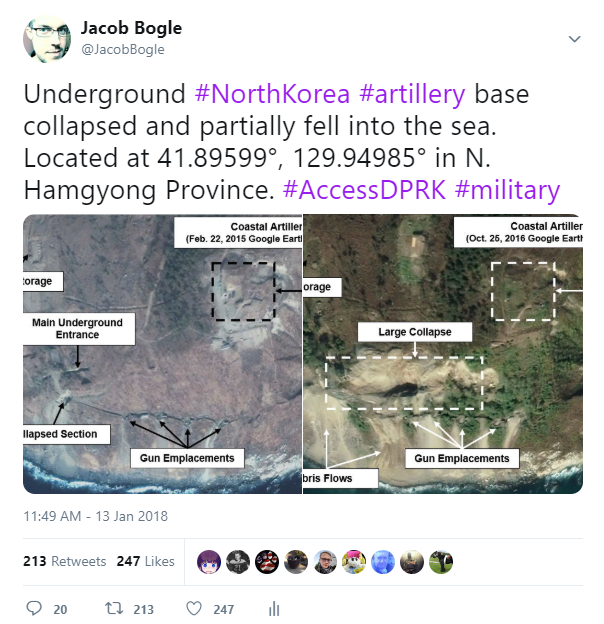
Here was 2018's top Tweet. It caught the attention of some international tabloids, and while sensational headlines isn't what I'm after, it did help direct people to the blog where they can get a more sober look at what's going on in the country.


I'm also proud to say that a GIS company reached out to me for some assistance with one of their projects earlier in the year, and I was able to help out. Additionally, I discovered that the RAND Corporation used parts of the Phase II map to help create their 2018 report, The Korean Peninsula: Three Dangerous Scenarios. It's always exciting to me when I see things being by use others (when proper credit is given, of course, which it was by RAND).

I have still been considering setting up a Patreon page, as I first discussed last year. Well, I've already set it up (not published) but I haven't quite figured out what direction I want to go with it (either to allow people to donate monthly or per article. What kind of rewards to offer, etc.) But considering the amount of time some of these things take (over 150 hours just on monuments), I don't think it's the right way to go to shoulder the full burden of research, buying new books/articles, up-keeping domains, etc. without some support from those most interested. Life does get the way at times, and having some added income would help speed things up and allow me to produce more content.

Here's looking forward to another year of shedding light on the Hermit Kingdom!


--Jacob Bogle, 1/1/2019
www.JacobBogle.com
Facebook.com/JacobBogle
Twitter.com/JacobBogle

Wednesday, January 3, 2018

AccessDPRK 2018 Update

2017 was an incredibly busy and important year for all things North Korea. From the murder of Kim Jong-nam, the unprecedented number of nuclear and missile tests, and even to the large construction projects that were seen in Pyongyang, last year certainly kept analysts and watchers chugging the coffee. Last year was also a big year #AccessDPRK: web traffic was more than double that of last year (for which I thank my readers very much!), I had the opportunity to give multiple radio interviews on different DPRK topics, social media presence grew, and most importantly, I was able to release the completed version of a very big map.
I intend 2018 to be a busy and big year, too. Let me tell you what I've been working on and about some future plans for this new year.


I published Phase I of the #AccessDPRK Mapping Project in March 2016 and Phase II was published a year later, in March 2017. Phase II became the largest and most comprehensive map of North Korea ever made public with over 53,000 locations mapped; far surpassing any previous public work. In the time since the initial publication, I have continued to highlight important and interesting finds via this blog and social media. I have also been working on the "topic specific" files that I mentioned in the Phase II release post. At the same time, I have continued work on keeping the main project up-to-date and have added scores of new sites of all types: military, monuments, and domestic.

It wouldn't quite be accurate to call this beginning a "Phase III", but I want everyone to know that I am certainly not finished with this undertaking and a true Phase III will be forthcoming at some future point. Over the course of this process I will be re-categorizing hundreds of "compounds" to reflect the greater importance they may now hold, I will be working to resolve a long-standing issue in identifying many interior HARTS locations (are they artillery sites or simply tunnels?), I will keep marking places that were inadvertently missed the first time around (like a monument or irrigation pumping station), and of course work on the topic specific files will continue.

Additionally, it's important to realize that all of the articles on this site are part of the broader #AccessDPRK project and are meant to enhance the work by giving it greater depth. There are a number of articles that I am currently drafting, and I have begun to use a range of new resources which will allow me to use more recent satellite images in a number of cases. That means I can provide you with better information and occasionally even help break some news.

Considering all of these things and the amount of time and effort it requires (I am just an individual and not backed by any organization), I am also thinking about setting up a Patreon (or similar) account to enable those who appreciate and enjoy what I produce to take part and assist. I'll have more on that later.

So I am looking forward to this new year and anticipate North Korea will provide us with ever more things to talk about and analyze. I appreciate your continued interest and all of the emails, comments, and interactions on social media. If you haven't already, please follow me on Twitter @JacobBogle and you can add me on Facebook, too. If you'd like to email me, the address is jacob_bogle@yahoo.com. I'm always open to suggestions on what topics to cover.


Finally, here's a small New Year's Bonus. (As always, click on the image for an enlarged version.)

A small military training base was recently constructed, and it is one of several to be built over the last few years.

Located 7.8 miles (12.6 km) east-northeast of Sariwon, N. Hwanghae, it is situated in a valley that also holds multiple other small military sites like tunnels and munitions/equipment storage depots. The location of the base is marked with a star icon and labeled, and all of the small yellow markers are the numerous other military sites in the region.


This next image shows the immediate area surrounding the training site. The several storage sites and tunnel group have also been marked out.


This is a 2014 image of the area, before the training facilities were constructed. Based on satellite data, the facilities were constructed between October 2016 and April 2017. I'm using a 2014 beforehand image because it's the best looking image showing the area.


In the latest satellite image, a number of changes to the old base can be seen. An assembly/parade ground has been established, new barracks constructed alongside the old observation hut, a small training site for fighting in trenches was set up, the water course has been updated, and a vehicle training course has been constructed.


Here is an enlarged version to make some of the details more visible. (Click on image for larger view.)


--Jacob Bogle, 1/3/2018
www.JacobBogle.com
Facebook.com/JacobBogle
Twitter.com/JacobBogle