Friday, December 22, 2023

Farming on the Frontier

North Korea shares 1,369.3 km of border with China and Russia. Predominately demarcated by the Yalu and Tumen rivers, the border regions are mountainous, with the available farmland often squeezed into thin strips or even onto islands that completely flood every few years.

With a few exceptions, such as the plains around Taehongdan and Onsong, farming in this region doesn't contribute significant amounts to the national food supply. However, they are important locally as are the forests which harbor herbs, mushrooms, and other plants used for food and in traditional medicines, and access to these lands provides additional income to local farmers and foragers. 

But, the government's response to the COVID-19 pandemic has placed that access at risk.

Through the construction of two layers of border fence, the land in between has become subjected to additional checkpoints, and many of the forests have become completely off limits. 

Farmer and ox cart at the Migok Collective Farm (2008). Image source: Stephan (Flickr), CC BY-SA 2.0.

North Korea has attempted to secure the full border in the past but never succeeded in doing so until COVID-19. Using the pandemic as justification, even the most impassable parts of the border are now fenced off with over 1,000 km of new fencing and thousands of additional guard posts having been constructed.

Even in this mountainous region of North Pyongan Province, where the Yalu swells to over two kilometers wide in some spots, electrified fencing has been erected to prevent anyone from fleeing the country.

As seen in the next image, the double row of fencing cuts through not only mountainous regions but also through farmland, disrupting the typical flow of human activity in those areas.

Detail of the border fence. Location: 42.967323° 129.999220°

Sometimes those fences are separated by only a few meters but in other areas it can be as much as a kilometer. In total, over 260 sq. km. of farmland and forest lies between the two fences, cut off from easy access. 

In this area, 17 sq. km. of land (highlighted in green) have been cut off by the two rows of fencing. 

In other areas, the fences run much closer together. At the narrowest point in this image, they are only 60 meters apart.

The land that has always belonged to official farms continues to be cultivated, even in places where the fences are close together, but the secondary fence prevents farmers from easily accessing that land, placing an additional hardship on them. Furthermore, parts of the border are alleged to hold landmines and the placement of those mines could further complicate the farmers' relationship with the lands they're required to work.

Checkpoint example #1 at 42.540183° 130.443553°.

Checkpoint example #2 at 42.544376° 130.477298°.

Positioned along roads that pass through the secondary fence are small checkpoints to verify the identification of everyone that tries to enter the border region. Not all of the existing road network remains open, however, with the fence just cutting across the road, and closing it. By limiting the number of access points, North Korea can funnel activity through a more manageable number of fence crossings, increasing overall security.


However, the fence doesn't only impact official farms. Illegal plots of farmland (sotoji) have been an integral part of North Korea's black market economy for decades, and they play an important role in supporting local economies and supplementing local food supplies, with corn, cabbage, potatoes, and soybeans being common crops.

Although the land in between the fences (and the illegal farms it holds) no longer appear to be openly accessible, entry to the sotoji could still be possible by bribing checkpoint officers as bribery and corruption is already rife in North Korea. If bribes are required, however, that is yet one more slice of income taken away from farmers (who, in the case of sotoji, could be anyone from professional farmers, teachers, and miners, to retired persons). 

If, however, access to the land has been permanently blocked and many or most of the fields are no longer cultivated, then that will have a direct impact on the many small villages and hamlets that can be found along the border region.

Examples of sotoji found within the fenced area. Location: 40.622524° 125.280157° 

In this area (imaged above) northeast of Pyoktong, North Pyongan Province, sotoji comprise roughly half of the land with forests occupying the other half.

Nationwide, an estimated 550,000 hectares are suspected of being sotoji, and DailyNK estimated that some 20% of all grain grown in the country in 2007 came from these irregular farms. Of course, land use patterns evolve over time, but as Andrei Lankov wrote in 2011, "the percentage of land under the cultivation of sotoji owners roughly equals that under cultivation by state-run farms" in some counties that border China. And, indeed, numerous of these illegal plots can be found within the new border fence area.

Crop yields nationwide have struggled in the last few years, but there haven't been any studies yet that focus on the border area that might tell us how the sotoji have fared with the construction of the border fence.

Whether it's a border blockade cutting off cross-border trade and impacting the lives of thousands living in the villages and hamlets of the area, or whether it's the construction of scores of additional checkpoints between towns and counties, and even surrounding Pyongyang, the government has used the pandemic as an excuse to crack down on human movement in ways greater than ever before.

Unfortunately, the difficulties imposed by the dual-layer border fence system on local populations aren't likely to lessen as authorities continue to extend the state's power over the economy and the freedom of movement. 


I would like to thank my current Patreon supporters who help make all of this possible: Alex Kleinman, Amanda Oh, Donald Pierce, Dylan D, Joe Bishop-Henchman, Jonathan J, Joel Parish, John Pike, Kbechs87, Russ Johnson, and Squadfan.

--Jacob Bogle, 12/22/2023

Tuesday, November 21, 2023

Post-COVID Update - Onpho and Tanchon

With internal pandemic restrictions slowly now lifting and international trade beginning to resume (albeit still at much reduced levels), some projects that had been stalled as a result of COVID and the government's anti-pandemic policies appear to be making progress once again.

Here are two projects where measurable progress has been made.


Onpho Holiday Camp

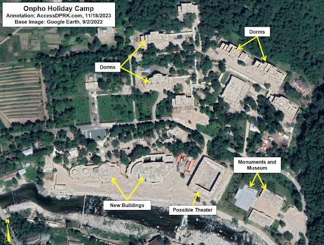
After visiting the Onpho Holiday Camp and Hot Springs (41.656463° 129.526877°) in July 2018, Kim Jong Un criticized the facility for being rundown and ordered that it be modernized immediately. Onpho has a long history, dating back to before the founding of the DPRK, and had served as a getaway for the country's elite for generations (including being visited by Kim Il Sung), which explains Kim Jong Un's anger at the state of the complex and his rush to modernize it.

Construction work began almost immediately after his visit, but economic factors began to be a drag on progress. Coupled with the pandemic, there was almost no headway made through all of 2020. And, indeed, after the August 2020 AccessDPRK report on the site, there was little more to tell - with only marginal progress being noted in 2021 and 2022.

Construction progress as of November 2020 with several new dorms under construction as well as a number of other buildings. 

By 2022, all buildings had additional progress made but remained unfinished.

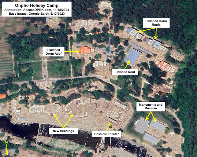
By 2023, some of the roofs had been put in place and the museum complex appears completed, but the three large, new buildings were still unfinished.

However, by September 2023, the exteriors of the three large buildings had all been completed four years after construction first began on them.

Onpho as of Sept. 14, 2023 showing that the exteriors of most buildings have been completed.

As mentioned earlier, Onpho caters to the country's elite. Located just a kilometer away, the complex contains at least eight villas of different sizes to accommodate important politicians, military leaders, and even Kim Jong Un should he visit again. However, the renovations to the holiday camp do not seem to have extended to this residential area.

While there hasn't been any official word as to when Onpho will reopen, the Yangdok Hot Springs (which underwent its own renovations from 2018-2019) reopened this summer after three years of closure due to COVID. But with the progression seen between June and September 2023 (the most in any three-month period since 2019), Onpho may finally be able to reopen next year unless there's another slow down.


Tanchon Hydroelectric Project

Path of the Tanchon hydroelectric tunnel and environs.

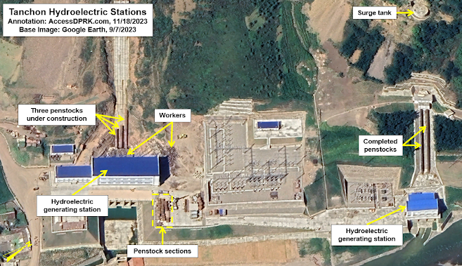
Plans to harvest energy from the Hochon River date back a century, but this latest endeavor began in 2017. With 60 km of tunnels, it's the largest hydroelectric project currently underway in North Korea. 

However, material shortages are a perennial problem on major projects in the country, and, made worse by the pandemic and border closures, the Tanchon Hydroelectric Project (40.787244° 128.444679°) still remains unfinished after six years. 

There was little noticeable progress made in 2022, but in the most recent Google Earth imagery, not only can progress be seen on the large penstocks, but crowds of workers are identifiable as well.  

Status of the Tanchon Hydroelectric Project as of Sept. 7, 2023.

If the penstocks are the final piece to the project (meaning that the generators are already in place), then Tanchon could come online in 2024, providing several megawatts of electricity to this key mining region. However, if North Korea hasn't managed to import or manufacture the complex turbine blades and generator components, then Tanchon may continue to sit idle for an indefinite period of time.


Despite the headway made at these two sites, there are still several others where no noticeable progress has been made, including on the Pyongyang General Hospital and the Wonsan Resort. The primary construction at both sites was completed over a year ago, but the government has not been able to acquire the necessary medical equipment and resort furnishings, leaving the sites as visible reminders of the government's overall inability to meet its own deadlines on some of its most publicized projects. 


I would like to thank my current Patreon supporters who help make all of this possible: Alex Kleinman, Amanda Oh, Donald Pierce, Dylan D, Joe Bishop-Henchman, Jonathan J, Joel Parish, John Pike, Kbechs87, Russ Johnson, and Squadfan.

--Jacob Bogle, 11/20/2023

Sunday, October 29, 2023

Inside North Korea 2023

As has become tradition with each new map release, here is a list of what's inside. Although this only reflects what the 2023 Pro Map captured, with over 70,500 sites mapped and organized into 100+ different types of location, AccessDPRK has sought to locate and describe every important military, economic, and cultural site within North Korea.

This latest release also gives me the opportunity to discuss in greater detail what the map contains as well as describe the improvements between this version and the 2021 version.


Without repeating the full backstory to AccessDPRK (which can be found throughout the blog), I began mapping the country in late 2012 as a hobby. Since then, it has ballooned into a methodical mapping project with this associated blog to share the various findings in detail. 

The AccessDPRK blog currently has 167 articles which would take up around 1,160 printed pages. I have also written for several other sites including NK News, Asia Times, and 38 North, and AccessDPRK discoveries have been reported on or cited by Radio Free Asia, Voice of America, DailyNK, UPI, Asahi Shimbun, Nikkei, The Atlantic, RAND Corp., and numerous others.

I've also been able to provide professional services to nearly a dozen of the top human rights, nonproliferation, and GIS organizations in the world.


Within the 2023 Pro Map update, more than 70,500 sites are included. This is a net increase of over 17,000 sites compared to the first free nationwide map that I made available back in 2017, when considering all the different changes that have occurred since.

With this update, I have tried to focus on mapping out changes specific to Kim Jong-un's rule as well as monitoring the evolving infrastructure changes due to COVID-19.

As with all my North Korea maps, the file is organized into four main divisions: monuments, military, domestic, and nationwide. The item counts that I've added further below gives even more details, but the general organization of the map is as follows.

The monuments folder is broken down by province and includes folders for Towers of Immortality and a folder for all other monuments. Many of the locations have notes on the type of monument they are (mural, statue, etc.) as well as dates for their construction.

The military folder is broken down by province and there is one for the DMZ. In total, there's over 40 subfolders for specific types of places like anti-aircraft artillery positions, navy bases, military storage sites, tunnels, etc. 

The domestic folder is broken down by province and also contains over 40 subfolders for specific types of places like dams, electrical substations, factories, markets, elite housing, schools, train stations, etc.

Both the military and domestic provincial folders also have an "uncategorized" subfolder that contains numerous other sites of interest that didn't warrant having their own dedicated folder (typically because there were just a handful of sites). And, most provinces also have at least one other folder that contains places unique to that province.

For the nationwide folder, that contains ten categories of places that I felt were better organized together instead of being spread out among each provincial folder. Nine categories would be considered "domestic" and one (the folder for ballistic missile bases) would normally be in the military folder.


Compared to the 2021 Pro Map, this update is only 9% larger; however, there were several thousand internal changes to existing sites along with the 9% of newly mapped ones. I go through some of those specific changes below.

Monuments


The 2023 Pro Map includes 711 additional monuments over the 2021 version. This is largely due to updated imagery compared to what was available at the end of 2020, when I was finalizing the 2021 map (released that January). But there are also examples of monuments being constructed throughout 2021-23 (and those construction dates are included). I was also able to remove a few monuments that had been demolished, and to move the position of the icon for several other monuments that were moved to new locations. 

Additionally, and this goes for the military and domestic sections as well, I tweaked the position of hundreds (if not more) of icons to address the "drift" that happens when Google Earth updates its imagery. The images are rarely laid along the precise same coordinates so, after a few years, the Google Earth icon's position may no longer exactly match the position of the object in the image - sometimes by as much as 10 meters. So, I tried to make as many of those corrections as possible.

In the process of updating the monuments folder, I noticed some clear construction trends and periods of greater building activity. I've already written two detailed reports (2019 and 2021) on the monuments in North Korea, but I may write one last one in the future that will discuss these observations in more detail.


Military


The 2023 Pro Map only has 233 net additional military locations compared to 2021, but there were quite a number of other changes to the folder.

For one, roughly 40 anti-aircraft artillery sites in the 2021 map were reanalyzed and determined to not be active sites, so they were recategorized as "decommissioned" and moved into that folder. 
Several new AAAs that were constructed recently are also now included, making this the most up-to-date map of North Korea's air defense network.

Surface-to-air missile bases, which had been included in the same folder as AAAs, were separated out into their own folder. The exact type of SAM (S-75, S-200 etc.) was also added to those sites as well as information on the nine suspected mock SAM installations.

I reviewed the DMZ to ensure I located every pertinent site, and I took the opportunity to redraw the various fences so that they match the terrain more closely. 

The Airport file now includes known civilian "aviation clubs" and also reflects the fact that several airports and airbases have been demolished in recent years.

Within the rest of the folder, I added radar system identifications to dozens of sites and reviewed and improved the classifications of sites within the "possible units", "compounds", and "factories" folders. I also added additional data to "military units" and "tunnels" when available. 

Domestic


The domestic section ended up with the largest number of additions by far with 12.5% more sites than in 2021.

This is in large part due to COVID infrastructure, but I was also able to pick up on a number of new constructions, located formerly unknown sites, and I also added the country's network of forest management centers (located within the farming/agriculture folder), and improved the disposition of Pyongyang's water supply system - that alone added nearly 100 extra sites.

As for COVID. I remapped the entire northern border and both coastlines as North Korea began to rebuild and install new electrified fences along those areas to seal the country off. The 2021 map had positively identified 1,693 km of coastal and border fence (excluding the DMZ). The 2023 update has identified 3,684 km of new and modernized fencing. 

Along with the fences, I estimate that North Korea constructed an additional 15,000 border guard posts. To keep myself from going crazy mapping each and every one of those, I have picked a representative sample by mapping random ones. Nonetheless, 4,575 guard posts and guard barracks are individually identified within the map.

Additions based on COVID infrastructure continue through the discovery of COVID isolation facilities built throughout the countryside (109 are presently located), and the discovery of an anti-pandemic barrier that's being built around Pyongyang. The barrier alone accounts for 320 new sites. 

Some of the other changes include 47 additional dams and weirs, 56 additional communication towers, 35 additional electrical substations, 26 newly identified marketplaces, 185 extra farming/agricultural facilities, 41 extra schools, 18 additional historic sites, 38 extra gas stations, and around a dozen newly identified prisons/detention centers. 

Among all of this, I also moved ~1,200 sites (of all types) out of the Pyongyang folders and into folders for North Hwanghae and South Pyongan provinces because Google Earth finally got around to correcting their borders. And, roughly 800 sites had additional information added to them such as construction dates, notes on renovations and major events, and relevant news links.


Notes: 

I want to add a few notes to help with context and prevent any confusion.

While most of the categories are indeed individual sites (there are 1,520 distinct electrical substations for example), some of the categories include not just the primary location but also sites within those places. A great example of this is that there are not 434 prisons in the country. There's 67 known, suspected, and former prisons that I was able to locate. And many of those prisons include detailed maps that also mark where the guard huts are, where prisoner housing is, and so on. So, one prison may be represented by 20+ items, and that's how I get to 434 total sites within the prison category.

The categories that have these more detailed folders are prisons, missile bases, some historic sites, several of the "elite compounds", and a few factories. Additionally, some of the "province only sites" include multiple sites per place. This is especially true in Pyongyang which has the most of these province-only sites. An example is the Ryongsong Residence, which located within the "province only" folder, but that one residence includes 47 detailed sites within its folder. So, while there are 1,043 markers within the whole "province only" category, they're only representing ~300 primary places as several of those primary places have numerous sites marked within.

Lastly, in some cases I did not try to map every single one of the sites within a category. There are notes in the respective folders saying this, but they are: irrigation pumping stations, water supply, factories, agricultural sites, internal security checkpoints, parks, and gates. I tried to map a majority of sites and all of the important ones with the exception of the water supply sites, agricultural sites, internal checkpoints, and gates. For those, I wanted to give a representative sample and to locate major places. I only marked gates in cases where a facility was large and the main entrance could be difficult to find, and in cases where the gate itself was interesting/large.


I would like to thank my current Patreon supporters who help make all of this possible: Alex Kleinman, Amanda Oh, Donald Pierce, Dylan D, Joe Bishop-Henchman, Jonathan J, Joel Parish, John Pike, Kbechs87, Russ Johnson, and Squadfan.

--Jacob Bogle, 10/28/2023

Friday, September 15, 2023

Pyongyang: COVID Fortress

AccessDPRK has been at the forefront of using satellite imagery to uncover North Korea's anti-pandemic measures. It was the first to use satellite imagery to verify reports of the "border blockade", it was the first to offer a nationwide look at those border changes via the AccessDPRK map, and it was the first to expose a network of covert COVID isolation facilities that was built across the country.

Screenshot of KCTV program (July 27, 2020) showing a COVID disinfection checkpoint along the Pyongyang-Kaesong Highway. Image source: NK News.

North Korea has used the pandemic to clamp down on human movement and trade in the most extreme ways, and it has relied on myths and pseudoscience to back up its policies. From claiming that COVID could pass into the country from Chinese dust to putting people in quarantine for coming into contact with objects from South Korea - despite there being very little evidence that one can contract the virus by simply touching an object - North Korea's anti-pandemic measures have caused an inordinate amount of harm.

Of course, given the state of the country's healthcare system, any pandemic could pose an existential threat to the state (to say nothing of the people living there). That is why it's little surprise to discover that authorities embarked on building not just border and coastal fences but have tried to erect an anti-COVID barrier around Pyongyang itself. 


First, however, I want to review the other infrastructure changes that North Korea has instituted in its fight against COVID.

North Korea was the first country to completely close their borders in response to the COVID-19 pandemic. To accomplish this, not only were all border crossings closed and trade & tourism suspended, but authorities erected hundreds of kilometers of new border fence (often in two layers) as well as repaired and modernized the existing border fences.

Map showing all border and coastal fencing as well as fences along the DMZ.

As part of the border closure, they added over 15,000 additional guard posts and garrisons along the border with China and Russia. They also improved security along both coastlines. AccessDPRK has verified the existence of 2,008 km of northern border fence and 1,567 km of coastal fence that now ring the country (plus hundreds of kilometers of DMZ fences). 

Within the country, numerous checkpoints were set up to further limit human movement and the spread of the disease. Some of these are simple tent-like structures where a person's temperature can be taken, and others are existing vehicle inspection points that have been expanded to allow for decontamination processes.

At the border crossings, most have simply remained shuttered. But at Sinuiju (the main crossing with China) and Tumanggang (the only crossing with Russia), new facilities to quarantine and disinfect goods and people were set up to handle what little trade has occurred since 2020, and to prepare for when trade is normalized again. There is also evidence of disinfection infrastructure being built at the ports of Nampo and Tanchon.

Location of all identified COVID isolation facilities. 

And as part of actually providing a level of medical care, albeit a questionable level, dozens of suspected COVID isolation facilities (95 at last count) have been constructed throughout the provinces. These highly secured compounds can isolate patients who test positive with COVID or have a severe "unidentified" fever, while not taking up additional room in the country's poorly staffed and supplied hospitals. Within Pyongyang, the city's hospitals have all had dedicated COVID wards set up.

It is within this context that I want to detail the latest apparent COVID infrastructure project: fencing off Pyongyang itself.

Map showing the location of the capital COVID fence. The yellow lines represent confirmed fence paths. The white lines represent rows of guard posts that may or may not be connected by fencing.

Because there are gaps in the available image data from Google Earth, I haven't been able to map out the full system as it exists today, but I have been able to locate enough of it to provide this review.

Beginning no earlier than March 2020, the construction of a series of fences, guard posts, garrisons, and checkpoints began. In parts of the city, the first iteration of the system was already built by October 2020, while in other areas construction extended until at least June 2022. 

Detailed look at the fence with a garrison building and guard posts visible.

Another detailed view of the fence. The fence's path is clear as are the guard posts and foot patrol path.

Based upon the available imagery, there are at least 63.2 km of clearly identifiable fencing with a further 22.9 km of rows of guard posts that may or may not also be connected by fencing. The guard posts are typically spaced every 75-100 meters. With 86.1 km of fenced and unfenced guard post lines, that means that roughly 1,000 guard posts (between 861 and 1,148) have been constructed around the city. 

Locations of garrison (barracks) buildings.

Just like with the country's border fence, these posts are supported by a network of at least 28 purpose-built garrisons (barracks) - six of which were actively under construction in June 2022. There are several other sites that I believe are now being used as garrisons, but they were previously used for other purposes. I haven't included them on the map because of a level of uncertainty. 

Locations of identified checkpoints, both pre-existing ones and newly constructed.

The fence system is also interconnected with the capital's checkpoint network and consists of 35 checkpoints of various types. Of those, twenty were built since 2020 and several of the preexisting sites have had visible upgrades. 

Explanation of gaps in the fence system. "Image gaps" refers to a lack of more recent imagery available on Google Earth.

There are parts of the terrain around Pyongyang where I have not been able to identify any new fencing. However, some of these areas are already "protected" by existing fences from factories or agricultural places, and those fences have been incorporated into the new system. Additionally, large sections of eastern Pyongyang are afforded security by the wide Taedong River (which serves a natural physical barrier), and northern sections of the city are mountainous and filled with military bases - effectively creating large swathes of inherently restricted territory. 


Thus, Pyongyang now sits at the center of a multilayered security network; a city that already required permits to visit, can now shut itself off from the rest of the country at-will. This doesn't only include restricting traffic from the main roads (an ability that has always existed), but even prevents Pyongyang farmers from coming too close to the city core by merely crossing a field on foot. 

The Central Quarantine Command oversees Pyongyang's anti-pandemic measures, instituting lockdowns, and enforcing the various government orders relating to the pandemic. However, whether or not this capital fence system is subordinate to the CQD, is part of the capital police force, or is part of a multi-agency force isn't yet known. 

I reached out to several North Korea experts including those with access to information from within the country, and only hints of information about this fence have begun to make it to outside researchers - and there had been no independent verification of it until now. It seems that North Korean authorities have been keen on keeping it a secret. 

However, as defector and former Pyongyang resident Hyun Seung Lee told me, it is "highly possible [that such a fence was constructed] since the country's top priority is Kim Jong Un's health. If anything COVID-19 related happened inside North Korea, none of the authorities will be free from responsibilities to protect the leader."

Considering the large number of checkpoints that already restricted access to Pyongyang, it may seem redundant to build dozens of kilometers of fences and a thousand guard posts to further cut off the city. Yet, North Korea not only built over 15,000 additional guard posts to seal off their northern border they also built fences all along the coastline. And so, North Korea seems to fight viruses with the same tactics as they would an invading army - block the enemy from being able to move. In this case, the general population plays the role of "enemy".

Although North Korea appears to be preparing to reopen its borders, it's clear that they have invested in the physical infrastructure needed to reenter lockdown at any time, and to continue to further restrict human movement within the country. This latest discovery underscores the paranoid nature of the state and demonstrates how Kim Jong Un would rather resort to force (sealing off the capital and placing thousands of guards on patrol) than take helpful steps like granting general access to vaccines or allowing adequate humanitarian aid into the country. 


I would like to thank my current Patreon supporters who help make all of this possible: Alex Kleinman, Amanda Oh, Donald Pierce, Dylan D, Joe Bishop-Henchman, Jonathan J, Joel Parish, John Pike, Kbechs87, Nate Odenkirk, Russ Johnson, and Squadfan.

--Jacob Bogle, 9/15/2023

Saturday, August 26, 2023

Building North Korea's Bomb

If you've ever looked at a diagram of a nuclear bomb (whether of Little Boy or of a modern miniaturized warhead like the W-87), you might be forgiven for thinking constructing such devices looks fairly straightforward.

For a gun-type fission weapon (like Little Boy), you simply fire a hollow chunk of uranium at a solid cylinder slug of uranium, setting off a chain reaction. For a simple implosion-type weapon, you just wrap a core of plutonium in a shell of conventional explosives and detonate it. That will create an implosion shockwave, compacting the plutonium until it reaches criticality and explodes with the force of thousands of tons of TNT. 

Even today's advanced two-stage thermonuclear weapons can be rendered in handy graphics. But the simplicity of popular descriptions of how nuclear bombs work belies their devilish complexity.

Diagram of the W-87 two-stage thermonuclear warhead used by the United States. Image: US News & World Report.

All of these descriptions and diagrams are simply distillations of feats of physics and engineering that took thousands of people and billions of dollars to produce in each of the countries that have developed their own weapons.

The world's nuclear weapons programs rely on physicists, engineers, often some of the most powerful supercomputers in history, and networks of manufacturing centers that are responsible for safely producing the uranium and plutonium needed as well as the scores of individual components that make up a working nuclear device.

In the United States, the primary assembly of nuclear warheads takes place at a single location in Texas. But that's just the final step in a long chain of research and production that involves facilities across the country, from the mountains of Tennessee to the deserts of New Mexico.

Likewise, North Korea's nuclear weapons program is a decentralized affair that includes mining sites surprisingly close to the DMZ to top secret underground storage facilities just a couple hours away from the border with China. 

In this article, I will attempt (with a caveat) to layout North Korea's nuclear weapons infrastructure. 

That caveat is: no country makes its nuclear secrets easy to uncover. Building a nuclear weapon takes the combined efforts of thousands of people, and uncovering the exact design components and in which factory which part is made is typically highly classified information. Because of that, this can't be a comprehensive exposé. There is still plenty about Pyongyang's nuclear program that isn't publicly known, and plenty that isn't even known to government intelligence agencies.

However, there is enough known information to provide a solid outline of many of the facilities North Korea uses to produce their nuclear arsenal.

With that in mind, let's get to it.


Kim Jong-un National Defense University.

The first steps to building a bomb are in research and development. For North Korea, this takes place at several institutions including the Atomic Energy Department of Kim Il-sung University (39.059259° 125.767729°), the Physics Department of Kim Jong-un National Defense University (39.169623° 125.776838°), as well as three departments within the Pyongsong College of Science (the Chemical Department, Physics Research Institute, and Atomic Energy Research Center). Additional research also takes place at some of the locations I'll discuss in greater detail below.

Once you have the theories and designs worked out, you need some raw materials.

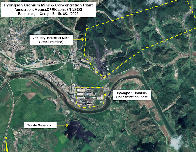
North Korea has modest uranium deposits and has mined it from locations across the country including at the Wolbisan Mine and at mines near Sonbong. However, North Korea's primary uranium mine is located in Pyongsan (38.323984° 126.436512°).

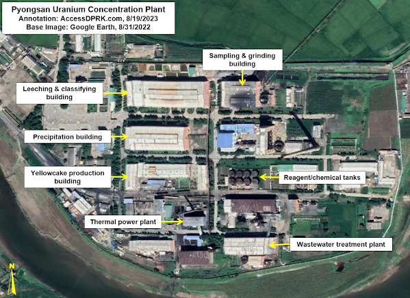
Pyongsan uranium mine and concentration plant. 

The Pyongsan uranium mine (also called the January Industrial Mine) is an anthracite coal mine that contains usable concentrations of uranium as an impurity. The mine has five mining shafts with one, possibly two, currently active. 

From the mine, the ore is taken via a conveyor system about 500-meters-long to the uranium concentration plant and mill.

The people over at Arms Control Wonk and the Center for Strategic and International Studies have written in-depth reports on the history and workings of the Pyongsan Uranium Concentration Plant. But here's a brief rundown.

Pyongsan Uranium Concentration Plant.

Construction on the plant began in 1985 and it was operational by 1990, albeit on a limited scale. Full-scale production wasn't reached until ca. 1995.

The ore is brought to Pyongsan where it is processed to separate out the uranium from the rest of the minerals found in the coal source material.

The uranium is found in reported concentrations of between 0.26% and 0.8%, and at least 10,000 tonnes of ore are mined each year; although, this estimate varies widely and annual production levels also vary year-to-year. This is then processed and concentrated into what's commonly known as yellowcake, which is 80% pure uranium. 

The uranium extraction process involves (simplistically): crushing the coal, sampling, grinding it down into a powder, adding sulfuric acid and sodium chlorate to leech out the uranium, washing it, running it through an extraction circuit and salt solution, and passing it through precipitation tanks where the concentrated uranium can be gathered, and dried. The yellowcake is then packed and shipped off for enrichment.

After processing, as much as 272 tonnes of yellowcake uranium leaves the plant annually in the form of triuranium octoxide (U3O8) and uranium dioxide (UO2). 

North Korea does have a second uranium concentration plant at Pakchon (39.710533° 125.568319°). It began operations in 1979 as a pilot plant, but has been in caretaker status since at least 2002, with only low-level activities noted from time to time, leaving Pyongsan as the only active uranium mill.  

From Pyongsan, the uranium needs to be enriched. There is only one verified enrichment facility, at Yongbyon. There is a suspected site near Pyongyang at Kangson (38.957195° 125.612159°), but there is considerable debate within published sources about Kangson's purpose.


Other raw materials besides uranium are needed to support the country's nuclear program (from graphite to tungsten), but which mines exactly are used isn't known. However, there are several identified mines that could provide North Korea with some of the needed materials. 

There are several specialty materials and components associated with uranium enrichment and modern warhead manufacturing that North Korea is not known to have the capabilities to produce domestically, but the country clearly has enough legacy technology and skill to overcome those shortcomings and to produce these deadly weapons. 


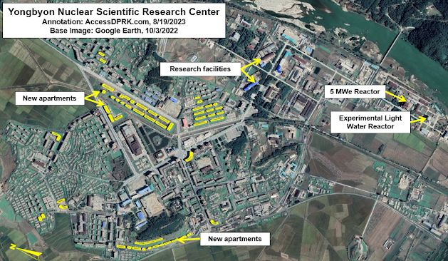
The Yongbyon Nuclear Scientific Research Center (39.796977° 125.755110°) is North Korea's key nuclear facility. With a history dating back to 1963-64, Yongbyon plays a central role the country's development of nuclear weapons.

Yongbyon Nuclear Scientific Research Center.

Located some 85 km north of Pyongyang, the complex covers a 24.8 sq. km. area that's surrounded by fences and guard posts. Within Yongbyon lies the town of Dong-an (formerly Sang-dong) which serves as the civilian quarter and houses all the scientists, researchers, technicians, their families, and everyone else needed to run the town and research centers. 

Southeast of the town is a walled compound containing the research center's administration, laboratories, and various other facilities. South of that, is an adjacent walled compound that houses the 5MWe nuclear reactor and the Experimental Light Water Reactor, as well as the spent fuel storage building. 

Elsewhere in Yongbyon is the Radiochemistry Laboratory (39.781174° 125.753286°) where plutonium is produced as well as radionuclides used in nuclear medicine. And then there is the uranium fuel fabrication facility (39.770255° 125.749224°) where the uranium brought in from Pyongsan is further processed and enriched into weapons-grade material. The fuel fabrication facility is also used to manufacture the fuel rods needed for the nuclear reactors.

The uranium complex at Yongbyon, including the enrichment halls.

Estimates place Yongbyon's annual capacity to be 100 kg of highly enriched uranium and 6 kg of plutonium. The enrichment hall at the uranium fuel facility was enlarged in 2013 and again in 2021, indicating an increase in North Korea's enrichment activities.

According to the Center for Arms Control and Non-Proliferation, North Korea has enough fissile material to build a further 45-55 nuclear warheads. 

Another change of note within Yongbyon has been the construction over the last decade of enough housing for ~3,200 new residents. The increase in Yongbyon personnel, the enlargement of the uranium fuel fabrication facility, and other changes in recent years (at Yongbyon and elsewhere) have enabled Kim Jong-un to ramp up the production of nuclear warheads.

This increase in capacity was reflected in a 2022 speech by Kim Jong-un in which he vowed to "exponentially increase" the size of the country's nuclear arsenal. 

However, simply having a pile of enriched uranium and plutonium doesn't a nuclear bomb make.


Yongdoktong nuclear complex.

Nuclear weapons use shaped charges made of conventional explosives as an "explosive lens" to collapse the inner shells within the device and lastly to compress the core of fissile material, initiating the chain reaction.

Yongdoktong (40.004320° 125.339377°), just east of Kusong, is where these lenses are developed, tested, and manufactured. 

A review of Landsat images reveals that construction of the complex began ca. 1987 with most of the work completed by 1992. In more recent years, several changes have been noted including at least 18 new buildings or building renovations since 2016, the addition of greenhouse and garden facilities in 2019, and ~47 new housing units, most of which were built since 2020. On top of that, in late 2020, a new building was constructed to cover the entrance to an underground facility near the main production center.

Explosive lenses are often produced at or near the same facility that conducts the final assembly of warheads. The size of Yongdoktong, its several distinct sections and underground sites - to me - makes it a candidate location for where North Korea builds their completed nuclear warheads.

Additionally, it is where intelligence sources suggest that North Korea stores its warheads in underground facilities within the complex. 

Regardless, warheads may then be taken from Yongdoktong to Punggye-ri for underground nuclear testing or they could be sent to one of a dozen or so ballistic missile bases.


Punggye-ri nuclear testing complex.

Punggye-ri (41.279084° 129.087133°) is North Korea's only nuclear test site. The facility runs south from Mount Mantap and down a valley for ~17 km. At the foot of Mount Mantap, four tunnels for underground nuclear testing were dug. From there, a series of administrative, support, and guard buildings are situated along the valley.

The exact year that Punggye-ri was established is difficult to ascertain but excavation work on the testing tunnels began in the early 2000s, and the site was being monitored by South Korean intelligence agencies as early as the 1990s.

To-date, six underground nuclear tests have been conducted, but only three of the four tunnels have ever been used. The first test took place in 2006 and the most recent (and most powerful) nuclear test occurred on Sept. 3, 2017. After that, North Korea announced that they had successfully completed the tests required to prove the validity of their nuclear weapons designs, and that Punggye-ri would be shuttered. 

On May 24, 2018, in front of foreign media who were especially invited to attend, the tunnel entrances were ceremonially blown up. However, doubts of Punggye-ri's closure were raised almost immediately. In the coming months and years, satellite evidence revealed that the facility had only been placed in caretaker status and remained suitable for future tests.

In 2022, new construction activity at the site was identified and U.S. officials later announced that the facility had been repaired and that further nuclear tests could take place at any time.

Validating the design of new warheads through testing is an important step in developing a credible nuclear force, particularly as North Korea advanced from testing crude nuclear devices (as in 2006) to developing miniaturized thermonuclear devices that could be mounted onto missiles. 

It is likely that further testing will be required as North Korea refines its designs and develops new variants. Currently, it is generally accepted that North Korea now possess ~30 operational nuclear warheads and is actively building more.


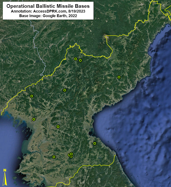
Map of known operational ballistic missile bases.

Ballistic missiles require adequate device miniaturization and heat shielding to deliver a functional warhead to the target. U.S. intelligence assessments concluded that North Korea had developed the capability to miniaturize a nuclear device and mount it onto a ballistic missile by 2017.

However, there is still debate whether or not Pyongyang has yet developed the capability to manufacture the necessary heat shielding for the reentry vehicles that are used in hypersonic missiles and MIRVs (multiple independently targetable reentry vehicles) that North Korea's seeking to acquire.

The country has around a dozen operational ballistic missile bases and a further dozen or so support facilities (for equipment storage, training, etc.). These bases are roughly divided into three "belts" around the country, with medium-to-intermediate range ballistic missiles and intercontinental ballistic missiles being deployed at bases in the "operational" and "strategic" belts (in the center and northern parts of the country respectively), and short-range missiles deployed in the "tactical" belt close to the DMZ. 

There are questions whether or not any warheads are actually stored at these missile bases, ready to be launched, or if they are all held at Yongdoktong and would only be moved to missile bases following a direct order from Kim Jong-un. 

Keeping them at Yongdoktong would introduce a serious delay in North Korea's ability to rapidly launch a nuclear-armed missile as the warheads would have to be transported from there to the bases. (The nearest operational base to Yongdoktong is over 50 km away by road.)

But for now, any discussions about deployed warheads or North Korea's nuclear command and control remains largely speculative.

What isn't speculative is that North Korea has worked for decades to develop the technology and infrastructure needed to build a nuclear arsenal, despite international condemnation and despite the tremendous hardships the nuclear program has caused the people of North Korea. 

And although I was able to highlight several publicly known nuclear facilities in this article, North Korea is known to have other undeclared research and industrial centers that play a role in the country's nuclear weapons program. Having a detailed accounting of these sites will be imperative to any successful denuclearization or arms limitations agreement in the future.


I would like to thank my current Patreon supporters who help make all of this possible: Alex Kleinman, Amanda Oh, Donald Pierce, Dylan D, Joe Bishop-Henchman, Jonathan J, Joel Parish, John Pike, JuneBug, Kbechs87, Nate Odenkirk, Russ Johnson, and Squadfan.

--Jacob Bogle, 8/26/2023

Monday, July 24, 2023
Kim Jong Un's Underground Pyongyang

Verifying the existence of underground facilities can be a difficult task, especially when their existence is a state secret. But rumors eventually come out and tantalizing hints of their presence can sometimes be found.

For North Korea, these rumors tell of secret subway lines beneath Pyongyang and underground highways connecting major palaces, maybe even reaching as far north as the border with China. I have written quite a lot about North Korea's underground infrastructure, but direct evidence and declassified sources still remain scarce. 

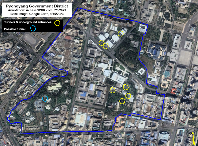
Overview of the Pyongyang Government District.

However, within the secured government district of Pyongyang are signs of multiple tunnels and underground structures. While it's impossible to know how they all connect to one another or even if they do, their locations and prevalence do hint at a fairly robust underground network that supports the infrastructure, transportation, and security needs of Pyongyang's most important district.

The easiest way to identify underground facilities is to either spot their entrances or actually catch them being constructed. For the secured government district, most of the buildings were constructed decades ago, placing their secrets out of reach for those without security clearances. But under Kim Jong Un, there have been some substantial changes to the district and that has given North Korea watchers an opportunity to see observe some of them.

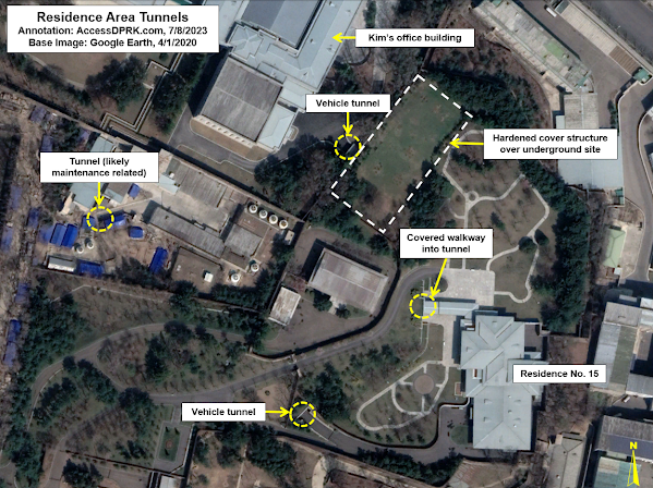
There are two main sets of tunnels within the 138-hectare district that are visible to satellite. The first is a set of four tunnels near the Central Committee Office building (also known as Kim Jong Un's office) and the adjacent villa (Residence No. 15). The second is a set of four tunnels leading to underground parking garages beneath three buildings that were constructed in 2018-2019.  

There is also a possible tunnel, marked in light blue, but I can't fully verify that it is a tunnel. In some images, however, it appears that there may be a road tunnel that dives under a gate near Kim Kyong-hui Hall, just south of Changgwangsan House.

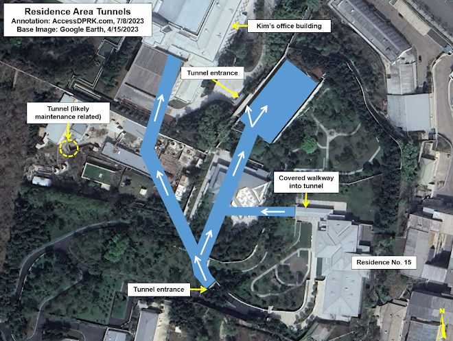
But the tunnels around Kim Jong Un's office and Residence No. 15 are quite clear.

April 10, 2020 image of the four tunnels around the Central Committee Building (Kim's office) and his district villa, Residence No. 15.

Apart from the tunnels by the villa and office, which I'll detail next, there is also a smaller tunnel in the maintenance complex. This complex handles building heating and cooling equipment, provides maintenance services, and may also play a role in electricity and water supply to the adjacent buildings. The tunnel (39.016557° 125.743544°) is 5-6 meters wide and runs toward the southwest. It's visible on all satellite imagery going back to 2000.

The tunnel may simply lead to a hardened bunker housing additional equipment or it could actually connect into the Office 39 complex (which includes the Kim Il Sung Revolutionary History Institute [39.016134° 125.741890°] and other Party buildings). Given its size and location, I do not think this tunnel plays any special security role. Rather, it's most likely just an access tunnel for providing building services.


April 1, 2023 image showing changes since 2020.

In 2022 a villa was rebuilt and enlarged, and in late 2022 a new hardened structure was built over the site of the tunnel nearest Kim's office building. 

The 'office tunnel' is large enough for vehicles and may lead to an underground garage or a larger underground complex. The hardened structure above it is approximately 60 by 30 meters in size and rises approximately 3 meters above the surrounding gardens.
Conjectured tunnel layout.

Due to the number of visible entrances, a concept of the tunnel layout can be formed with some confidence despite not having all the information. 

The covered walkway from Residence No. 15 was constructed in 2010. It resembles another such walkway that was built in 2017 in the armed forces district 5 km north at 39.062677° 125.740196°. 

The southern tunnel entrance was also constructed ca. 2010-11. Following the path drawn in the above image, the southern tunnel is about ~150 meters from the northern tunnel at the Central Committee Office Building (CCOB). 

The northern tunnel, however, was only constructed in 2018. This means that the southern tunnel likely went directly to the CCOB, where an alleged 60-car garage also exists beneath the assembly hall. 
This connection allows people from Residence No. 15 to travel on foot or by car directly and safely to the CCOB. Then, in 2018, a new tunnel was built from the CCOB that would link up with the southern tunnel.

This construction also included the building of an underground structure which was later (2022) replaced by the 60 x 30-meter hardened structure now seen in satellite images. Allegedly, a small, electrified rail car is also employed within the tunnels, but I haven't seen any supporting evidence of that.

To the north of the Central Committee Office Building, between 2018 and 2020 four currently unidentified buildings were constructed. These buildings include glass-covered entrances to underground parking garages that, most likely, would also double as bomb shelters in the event of an air attack.

Underground garage entrances under construction in June 2020.

The underground garage entrances after completion are covered by glass canopies.


There are also reports (including from Hwang Jang-yop) that the Pyongyang Metro has a secret line for government use that connects important government and military installations around the capital, and that it even reaches as far as Nampo and Sunchon (50 km away). While this has never been independently verified, the government district does lie within 2 km of four subway stations, with the closest being Pongwa Station at only 600 meters away from Kim's office.

As most of the district was constructed in the 1960s and 1970s (as was the metro), underground entrances to the metro system could be hidden beneath key administrative buildings, beyond the prying eye of today's satellite fleet. I have doubts about a sprawling network of transportation tunnels connecting far flung facilities, but a local network connecting underground command centers and emergency escape routes is quite plausible. 

Location of other known tunnels and underground facilities (UGF).

Whether underground sites exist in isolation or connect to larger tunnel networks beneath the government district and beyond, the sheer number of bomb shelters and other underground facilities alleged to exist makes the possibility of a successful "decapitation strike" by South Korea or the United States far more difficult and less likely to be effective, as such an attack relies on knowing where the target individuals are and killing them before they have time to escape to another location.

While I can't comment as to the quality of their construction, as a regime hyper-focused on survivability, North Korea probably has the greatest density of underground facilities and secret tunnels of any country on earth. 


I would like to thank my current Patreon supporters who help make all of this possible: Alex Kleinman, Amanda Oh, Donald Pierce, Dylan D, Joe Bishop-Henchman, Jonathan J, Joel Parish, John Pike, JuneBug, Kbechs87, Nate Odenkirk, Russ Johnson, and Squadfan.

--Jacob Bogle, July 24, 2023