Showing posts with label 2021. Show all posts

Sunday, February 26, 2023

AccessDPRK Free Map Update 1.1


Two years I ago I published the largest freely available map on North Korea ever created. After creating maps for a decade, I didn't want to keep re-mapping the whole country over and over. However, North Korea isn't static and things change over time.

So while I haven't made a completely new version, I have updated the original 2021 free map to reflect some of those changes.

Everything I do is done with Google Earth because it's the most accessible and user friendly program out there, and I want people to be able to explore North Korea without needing special skills or having to buy incredibly expensive software. 

One of the biggest changes to the map that's included in this update is due to the fact that Google Earth updated their own map of North Korea's administrative boundaries to more accurately reflect them. This is important because AccessDPRK maps are organized by province. 

As a result of the changes, around 800 places that had been in Pyongyang now show up as being in different provinces (because they are). So I have gone through and moved all of those military, economic, and other sites out of the Pyongyang folders and into the folders of their "new" provinces. 

I also reviewed all of the anti-aircraft artillery batteries as part of an article I wrote last year and updated nearly 100 sites to give users the most up-to-date look at all of the active AAA locations. 

Other changes include redrawn fences of the DMZ as small sections have been moved around/rebuilt, and to take into account the "drift" that happens when new satellite imagery is added that can cause placemarks and the objects they're marking to appear slightly out of line. So now everything lines up better to reflect current imagery.

I have added additional gun emplacements in the DMZ, around 20 new "children's driving parks", updated all of the coastal fences, and made several other additions, corrections (like typos), added names to more sites, and made other small changes throughout. 

You can download this free file here

The file name is AccessDPRK_2021 Free Version-1.1 (2.2023) and it is 4.8 MB in size and contains over 61,400 items.

I am also in the process of doing a full update of the Pro Version and will hopefully be able to publish it later this year.


I would like to thank my current Patreon supporters who help make all of this possible: Alex Kleinman, Amanda Oh, Donald Pierce, Dylan D, GreatPoppo, Jonathan J, Joel Parish, John Pike, JuneBug, Kbechs87, Russ Johnson, and Squadfan.

--Jacob Bogle, 2/26/2023

Monday, January 3, 2022

AccessDPRK in 2021

This last year marked a milestone for AccessDPRK, and thanks to your continued readership and the support of my Patreon supporters, 2022 will see some great additions to the project.


The biggest event of the year, of course, was the publication of the Phase III map.

The journey that led to the 2021 map began in December 2012, and after 7,000 hours of work, I was finally able to publish the final version of this nationwide map. 

The Free Version contains over 61,000 locations of interest. The Pro Version includes an extra 3,400 locations along with added information on thousands of others. In terms of locating military bases, industrial facilities, and cultural sites, it's the most comprehensive map available to the public...anywhere.


For the AccessDPRK blog, I was able to write 21 articles and analyzed 116 images for those articles. I also started the Kim Jong-un's First Decade in Power biographical series which takes a look at his first decade ruling the country. The series is broken down into twelve topical articles and eight have already been published.

The top 5 articles of the year were:

  1.  What's Inside North Korea?
  2.  Is Wonsan Prison No. 88 Closing?
  3.  What Lies Beneath the Underground Republic
  4.  Border Blockade
  5.  The Unique Buildings of NK's Missile Program
AccessDPRK articles were also cited by Chosun Ilbo, One Earth Future Foundation, i News and various other UK papers.

The blog's 142 articles now contain the equivalent of 937 printed pages of material and include 938 images. I also added 65 images this year through Twitter that are not duplicated in the articles on this blog. In total, I've added nearly 500 Twitter images, providing a very large range of visual material for those interested. 

Web traffic to the site increased by nearly 20% year-over-year. On Twitter, I added 185 new followers and AccessDPRK-related tweets earned 346,000 impressions. The year's most 'popular' tweet was one in response to North Korea's September 2021 cruise missile test and reported range.


As announced at the start of 2021, I also began working on a book. Thanks, in particular, to my Patreon supporters I was able to purchase several books and journal articles to help research for mine. The future book's current layout is broken down into three main sections and will contain seventeen chapters. Of course, this is subject to change.

 
Looking to 2022

The amount of work required to research and write the biographical series necessitated that I largely take a break from other parts of AccessDPRK, but once the series is finished, I will be focused on completing the watershed map and the map of DMZ trenches. I will also work toward editing and publishing the rest of the 31 'city briefs' that I have written on various towns across the country.

Afterward, I would really like to place more focus on research and writing my book. Although that may mean less blog activity, I will still be looking out for new changes in North Korea and if a topic piques my interest, I'll write a post about it. I currently have a list of 20 article ideas & drafts, so there shouldn't be a dramatic decline in regular content output. It just won't be my main focus.


Patreon

I set up a Patreon account in 2020 and have gained some great supporters. Currently, you can help support the project for $3, $5, $10, $15, and $20 monthly, each coming with its own rewards.

I am constantly thinking about new rewards to add, one of them being that I am working on a kind of virtual tour of the country. But you can already get early access to new articles, monthly digests that feature information I haven't discussed publicly, you can have me analyze places you're interested in, and get access to multiple exclusive datasets. Plus, blog and Twitter mentions for any support at $3 or more.

If you believe in sharing facts-based information with the public about all aspects of North Korea (defense, culture, economy), please think about helping out. Every dollar really does help make this possible.

With that, I want to give a huge THANK YOU to my Patreon supporters throughout the year: Amanda O., Anders O., GreatPoppo, Joel Parish, John Pike, Kbechs87, Planefag, Rinmanah, Russ Johnson, and ZS.

Lastly, I want to wish everyone a wonderful upcoming year!


--Jacob Bogle, 1/2/2022
AccessDPRK.com
JacobBogle.com
Facebook.com/accessdprk
Twitter.com/JacobBogle

Saturday, December 25, 2021

Update on the Pakchon Uranium Mill

The Pakchon Uranium Concentrate Pilot Plant is the first uranium concentration plant in North Korea and is one of only two known to exist, the other being the Pyongsan plant

Operations at Pakchon take uranium-bearing ore (usually from coal) and concentrate it into 'yellowcake' which has a uranium concentration of 99% pure U-238, a low radioactivity, long half-life form of uranium. From here, it is sent to other sites (such as Yongbyon) where it is converted into highly enriched U-235 which can be used for bomb production.

However, its operations have been scaled down and it has been in caretaker status since perhaps as far back as 2002.

But although uranium production has been shunted to the more modern Pyongsan, Pakchon's caretaker status certainly doesn't mean abandoned. Recent satellite imagery suggests at least some limited operations are still ongoing and that the regime has been fairly active in maintaining the complex. The continued importance of Pakchon in the country's nuclear program is evidenced by the fact that the United States was interested in having it permanently closed and dismantled as one of five nuclear facilities offered up by North Korea in exchange for sanctions relief. 

When I first wrote about the site in 2019, I noted two buildings that were either being demolished or that had been left to fall apart. Since then, commercial satellite imagery from Sept. 14, 2021 shows that one of those buildings has been completely reconstructed. Additionally, a repaired section of roof on the main milling building can be identified.

The imagery also shows that the complex's administrative section has seen construction and that the waste material reservoir is still being used.

The nearby mine that provides uranium-bearing ore has also been continually active. Whether it's sending its full production to the Pyongsan Uranium Mill or diverting small amounts to Pakchon, I can't say, but the improvements made at Pakchon suggests that the ore from the mine would likely one day be sent back to Pakchon if it becomes reactivated in the future.


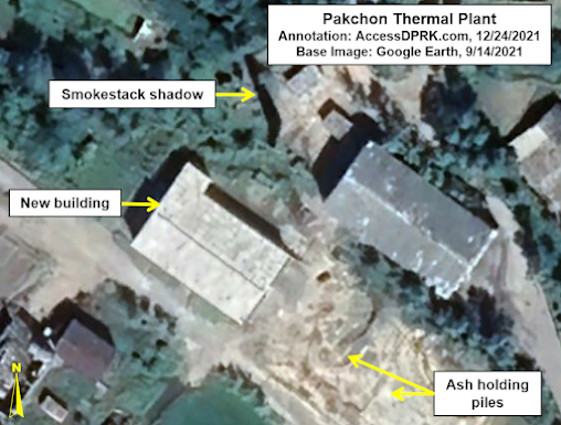
Taking these changes one-by-one, the first I'll talk about is the reconstruction of the thermal building which provides extra electricity for the plant. 

Thermal plant as seen on March 19, 2012.

In the above image from 2012, the thermal plant complex is clearly visible. Coal is housed in the bulk storage building where it is then moved uphill via a conveyor belt to the generating hall. The coal ash is then dumped outside of the building in a pile next to the conveyor where it accumulates until removed.

In 2019, the generator hall was being demolished.


By October 2019, the generating hall had been torn down to its foundations.

There is a gap in the Google Earth imagery, but by September 2021, a new structure can be seen.


The absence of a conveyor system, either above or below ground, suggests that construction to modernize the plant may not yet be complete.

Nearby are two other unidentified support buildings that have been left to fall apart.

Building #1 has a partially collapsed roof while building #2 is missing its roof entirely.


In this image, from right to left, you can follow the production process as described by the Center for Strategic International Studies.

The September 14, 2021 image also shows that a section of roof has been repaired in the section of the production building that is responsible for drying and filtering the yellowcake uranium before it is shipped out.


Pakchon's waste reservoir is split into two reservoirs, an upper and a lower one, divided by an earthen dam. The area of the reservoir that is filled with waste is approximately 3.4 hectares, with the upper section usually being filled with water and the lower section containing sludge and newer waste materials.

While the size of the reservoir hasn't changed in at least 17 years, the sludge pool has seen continued activity, particularly in the last few years. 

Beginning in 2019, a new staging area was constructed to accommodate vehicles and other equipment involved in the management of the reservoir. The staging area covers roughly 2,900 sq. .m. 


One other section of the Pakchon complex that has seen recent activity is in the administrative area. In 2019 a new theater/assembly hall was constructed over the course of the year.

The new hall is on top of substantial construction work that happened between 2008 and 2012, when nearly every current structure visible was either renovated or added.

Additionally, the fish farm that exists next to the administrative area had more modern facilities built in 2019-2020. These fish farms can be found throughout the country and help provide needed protein to local workers, military personnel, and the fish can even be exported to earn the country foreign currency.  


While none of this activity suggests full-scale operations have resumed at the concentration plant, it does support the idea that, like Punggye-ri, the site remains part of the country's nuclear program and may be ready to resume limited production should the order come.

As Joseph Bermudez wrote for CSIS back in 2019 about the low-level activity that can be observed, "the most likely explanations for this activity would be small processing runs of iron-bearing ore of some type, caretaker maintenance work, or decommissioning of equipment within the plant." 

However, with the newer imagery and changes, I would like to suggest that some of the activity could be part of pollution mitigation efforts or reprocessing older ore/waste material to extract small amounts of formerly discarded minerals (an activity seen at certain mining sites in recent years).


I would like to thank my current Patreon supporters: Amanda O., GreatPoppo, Joel Parish, John Pike, Kbechs87, Rinmanah, and Russ Johnson.

--Jacob Bogle, 12/24/2021
AccessDPRK.com
JacobBogle.com
Facebook.com/accessdprk
Twitter.com/JacobBogle

Sunday, March 28, 2021

What's Inside North Korea?


This is a breakdown of North Korea by the numbers based on the AccessDPRK 2021 Map, Pro Version. This is similar to the North Korea by the Numbers post I made for the 2017 map.

Since I want to give a full accounting of all of the different places that are in the country, I am basing this off of the Pro map, which has thousands more places than the free version


My interest in North Korea began in late 2012, then I found some older maps others had done and decided to make a truly comprehensive version, as all of the others were either severely lacking or only focused on one sector (like Planman's great work on air defense sites). I started the blog in 2013 and released an early version of the work in 2016. Then came the first "full" map in 2017 and finally the 2021 map, which will be the last comprehensive nationwide map of the country I plan to make. 

As all of my maps have been divided into monuments, military, and domestic sites, I'll give their overall numbers first.

The project has located 11,661 extant monuments in North Korea. There's 13,566 military sites (manned, unmanned, and former). And there's 39,407 domestic sites marked. This represents a 18.1% increase from the 2017 map; however, the military folder is actually over 41% larger than the 2017 military folder. That's 64,634 sites.


The provincial breakdown for the monuments is:


In 2019 I published an initial survey of the country's monuments. The total figures have grown slightly since then, but the article also talks about other monument-related things and is worth checking out.

Compared to 2017, thanks to improved imagery and new construction, there are 1,765 more monuments located. The Pro version also includes the dates many were constructed, and from that we can now know that at least 623 monuments, murals, and bronze statues have been installed under Kim Jong Un. 

There are also three sites in Pyongyang that are prepared for future statues, but the statues have not been erected yet. 


The military folder of the 2021 Pro Map is over 41% larger than the 2017 military folder. This isn't because I missed a bunch of places, but it's due to the fact that I wanted to give an even more granular look at the country's military, trends, and changes over time. This means I focused on mapping even former facilities, located the storage sites within military bases, paid special attention to locating tunnels and underground sites that may have been well hidden, and marked important bases (like missile sites) with greater detail. The change is also due to improvements in available imagery, making it possible to discover things that were previously too blurry to be identifiable. 

A few of the specific improved numbers are: 110 additional observation posts along the DMZ (at least 18 were built after 2015), 44 additional radar facilities, 67 more AAA sites (15 were built from 2015-2019), and over 400 additional verified military bases. Then there's the 126 hardened artillery sites that have been constructed since 2010. However, one of the largest increases comes from the storage facilities (stand-alone and within other bases) that I gave more attention to for 2021. The map includes 1,337 of them. That's a further 650 sites compared to 2017.

Since I have also tried to locate former artillery sites (so that other maps can be updated) and additional decommissioned bases to help researchers understand military infrastructure trends, I think it's important to say that of the 13,566 military-related sites, only about 900 (or 6.6%) are not part of the country's active defense. That means there's roughly 12,666 currently used sites (everything from missile bases to static, anti-invasion road blocks to tunnel groups and DMZ posts).


A notable change between 2017 and 2021 is the fact that there are 314 fewer propaganda signs marked. This is because many of them are simple wooden signs or chalk outlines on hillsides. Over time they fall down or are washed away. 

The demolition or other removal of sites, plus the fact that I did not include two 2017 categories (mountain peaks and Pyongyang bridges), means that the gross difference between the two maps is actually closer to 21-22%, and that the 2021 Pro map has ~11,600 entirely new places vs. 2017.

Some other changes worth noting is that there are 320 additional dams and hydroelectric sites marked, 71 additional markets, 371 more border posts (reflecting Kim Jong Un's efforts over the years to end defections), and there's the places that can only be found in the Pro Version. These include 149 gas stations (a growing trend in the country), the locations of 320 likely Railway Security Bureau facilities, and a national map of the country's lighthouses (some of which were only built in recent years).


Notes:

I want to add a few notes to help with context and prevent any confusion.

While most of the categories are indeed individual sites (there are 1,485 distinct electrical substations for example), some of the categories include not just the primary location but also sites within those places. A great example of this is that there are not 412 prisons in the country. There's 53 known, suspected, and former prisons that I was able to locate. And many of those prisons include detailed maps that also mark where the guard huts are, where prisoner housing is, and so on. So, one prison may be represented by 20+ items, and that's how I get to 412 total sites within the prison category.

The categories that have these more detailed folders are: prisons, missile bases, some historic sites, several of the "elite compounds", and a few factories. Additionally, some of the "province only sites" include multiple sites per place. This is especially true in Pyongyang which has the most of these province-only sites. An example is the Ryongsong Residence, which located within the "province only" folder, but that one residence includes 47 detailed sites within its folder. So, while there are 681 markers within the whole "province only" category, they're only representing around 275 primary places as several of those primary places have numerous sites marked within.

Lastly, in some cases I did not try to map every single one of the sites within a category. There are notes in the respective folders saying this, but they are: irrigation pumping stations, water supply, factories, agricultural sites, internal security checkpoints, parks, and gates. I tried to map a majority of sites and all of the important ones with the exception of the water supply sites, agricultural sites, internal checkpoints, and gates. For those, I wanted to give a representative sample and to locate major places. I only marked gates in cases where a facility was large and the main entrance could be difficult to find, and in cases where the gate itself was interesting/large.


I would like to thank my current Patreon supporters: Amanda O., GreatPoppo, Joel Parish, John Pike, Kbechs87, Planefag, and Russ Johnson.

--Jacob Bogle, 3/27/2021

Monday, February 1, 2021

AccessDPRK 2021 Map - Free Version

This image is an example of the domestic sites using the real icons in the map.

I started mapping North Korea in late 2012, released the first completed map in 2017, and began to remap the whole country in 2018. I wanted to keep track of changes, fix any old mistakes I came across, and to look for things that may have been missed during the initial phases of the project.

The combined result of roughly 7,000 hours of work is this 2021 free version. It contains over 61,000 places that are divided into three main categories: monuments, military, and domestic. Those are further broken down by province to give a more granular look at the country.

During the remapping process, I came across hundreds of places that had been mapped in 2017 but now no longer exist (mostly things like propaganda and town signs), so the true difference between the 2017 and 2021 versions comes to about an extra 8,500 places. Additionally, there were some categorization changes, new descriptions for hundreds of locations, and other changes. 

This Google Earth map is the most comprehensive look at the country freely available to the public. With some variation, there are 38-40 individual item categories in the domestic and economic section (everything from mining locations to irrigation pumping stations to factories and museums, schools and border security), and there are around 20 item categories in the military section. This has air defense sites, military bases, storage facilities, radar sites, etc. 

The monument's section is divided into Towers of Eternal Life and "others". Those include everything from murals to "On the Spot Guidance" memorials and everything else.

There is also a "nationwide" folder that is not divided into provinces but that holds all of the same type of place within single nationwide folders. The places in this section are: Historic Sites, DPRK Missile Bases, Prisons, Children's Traffic Parks, and Border Crossings (current and former). 

A note on the process of making this. As I have mentioned in previous blog posts, this project has been created by myself. I have no staff and no regular financial backing other than my great Patreon supporters. I have used what public information I could find in a reasonable amount of time (I can't read everything that comes out about the country), as well as my own experience to build this database.

I drew from older databases, books, government reports, western media, official North Korea media, think tank papers, conversations with knowledgeable people, and even sites like Wikipedia to help create it.

It is based on open-source information and geared toward English language readers. The Free and Pro versions have different levels of sourcing, but I almost exclusively stuck to English websites if I felt a location needed a link for reference. That means lots of places don't have links and many others don't need one at all.

For example, this is an anti-aircraft artillery battery. There is no need for some declassified document giving out the coordinates for this individual place. It is what it is, and there's around 1,500 of them.


As I said, not every place with a name will have a link. But for every place that does have a non-generic name, that name came from a source. Some of the locations were marked years ago, some were only marked within the last few months. Some online sources no longer exist, others have been archived. And other additional online sources may well exist, but if I don't know of them, I obviously can't add them.

I am not aware of any major, public database on North Korea that provides a citation for every single site (not even in cases when they're named and given other details). Sometimes the information comes from private discussions with defectors, other times it's drawn from old documentaries or DPRK media that no longer exists online (YouTube has conducted multiple purges of videos from official sources). In the process of creating this, I relied on established and trusted sources. 

If multiple sources say there's a missile base near Anbyon but with no specific coordinates, and I find a site with several indicators suggesting a site near Anbyon is a missile base, then that place will be marked as a potential missile base. If a building looks exactly like other known buildings, then it's going to get identified as that type of building (primary schools are a great example of this). 

This is a good faith, open-source project. Nothing more, nothing less. And out of over 61,000 places, errors probably exist. I do not guarantee that it is inerrant. Indeed, honest mistakes popup all the time, everywhere. I am trying to add to the world's available knowledge of the country and to seek the input and cooperation of others in filling in any holes or fixing mistakes. If you have any specific questions, feel free to ask.


Free Version Download & Operation

Here is the direct download link (version 1.1, 2023). The file is hosted via Google and is a little less than 5 MB in size. A new page will open and all you have to do is click the download button.

Simplified download screen. Yours may look different based on your browser.

If you're not familiar with Google Earth, it's pretty simple. Once you download the file, all you have to do is expand the menu (the little right-side arrows) to show the main sections. Pick one and expand it, decide which province you want to look at and expand that folder, and then pick the item(s) categories you're interested in. If you want to look at all of a particular site for the whole country, just click on each of the files within the various provinces.


Pro Version

If you're interested in the Pro Version, this page has a lot more information. In short, it contains nearly 9,100 additional places and over 3,000 other sites have extra bits of information such as links, construction dates, purposes and capacities, etc. 

For those interested in professional research or commercial/media interests, the Pro Version may be right for your needs.


Copyright Information

Aspects within the Free and Pro versions of the file may be subject to copyright and intellectual property rights enforcement under United States' law. No part of either version of the file may be used for commercial purposes without the express written permission of Jacob Bogle. This includes but is not limited to: use in contract bidding or fulfilling contracts for private or government interests; use in creating articles, films, maps, graphics, or other content for a profit-based entity; the creation of any map, dataset, or GIS product on a website or app that requires paid access to use that website or app. 


UPDATE: I have added an updated version, v1.1 (2023) in February 2023. It contains a number of changes to reflect provincial border adjustments, the addition of some new places, and corrected typos. The above download link is for the updated map. For more specific information, see here.


I would like to thank my current Patreon supporters for their continued support: Amanda O., Anders O., GreatPoppo, Joel Parish, John Pike, Kbechs87, Planefag, and Russ Johnson.