Showing posts with label Google Earth. Show all posts

Monday, February 1, 2021

AccessDPRK 2021 Map - Free Version

This image is an example of the domestic sites using the real icons in the map.

I started mapping North Korea in late 2012, released the first completed map in 2017, and began to remap the whole country in 2018. I wanted to keep track of changes, fix any old mistakes I came across, and to look for things that may have been missed during the initial phases of the project.

The combined result of roughly 7,000 hours of work is this 2021 free version. It contains over 61,000 places that are divided into three main categories: monuments, military, and domestic. Those are further broken down by province to give a more granular look at the country.

During the remapping process, I came across hundreds of places that had been mapped in 2017 but now no longer exist (mostly things like propaganda and town signs), so the true difference between the 2017 and 2021 versions comes to about an extra 8,500 places. Additionally, there were some categorization changes, new descriptions for hundreds of locations, and other changes. 

This Google Earth map is the most comprehensive look at the country freely available to the public. With some variation, there are 38-40 individual item categories in the domestic and economic section (everything from mining locations to irrigation pumping stations to factories and museums, schools and border security), and there are around 20 item categories in the military section. This has air defense sites, military bases, storage facilities, radar sites, etc. 

The monument's section is divided into Towers of Eternal Life and "others". Those include everything from murals to "On the Spot Guidance" memorials and everything else.

There is also a "nationwide" folder that is not divided into provinces but that holds all of the same type of place within single nationwide folders. The places in this section are: Historic Sites, DPRK Missile Bases, Prisons, Children's Traffic Parks, and Border Crossings (current and former). 

A note on the process of making this. As I have mentioned in previous blog posts, this project has been created by myself. I have no staff and no regular financial backing other than my great Patreon supporters. I have used what public information I could find in a reasonable amount of time (I can't read everything that comes out about the country), as well as my own experience to build this database.

I drew from older databases, books, government reports, western media, official North Korea media, think tank papers, conversations with knowledgeable people, and even sites like Wikipedia to help create it.

It is based on open-source information and geared toward English language readers. The Free and Pro versions have different levels of sourcing, but I almost exclusively stuck to English websites if I felt a location needed a link for reference. That means lots of places don't have links and many others don't need one at all.

For example, this is an anti-aircraft artillery battery. There is no need for some declassified document giving out the coordinates for this individual place. It is what it is, and there's around 1,500 of them.


As I said, not every place with a name will have a link. But for every place that does have a non-generic name, that name came from a source. Some of the locations were marked years ago, some were only marked within the last few months. Some online sources no longer exist, others have been archived. And other additional online sources may well exist, but if I don't know of them, I obviously can't add them.

I am not aware of any major, public database on North Korea that provides a citation for every single site (not even in cases when they're named and given other details). Sometimes the information comes from private discussions with defectors, other times it's drawn from old documentaries or DPRK media that no longer exists online (YouTube has conducted multiple purges of videos from official sources). In the process of creating this, I relied on established and trusted sources. 

If multiple sources say there's a missile base near Anbyon but with no specific coordinates, and I find a site with several indicators suggesting a site near Anbyon is a missile base, then that place will be marked as a potential missile base. If a building looks exactly like other known buildings, then it's going to get identified as that type of building (primary schools are a great example of this). 

This is a good faith, open-source project. Nothing more, nothing less. And out of over 61,000 places, errors probably exist. I do not guarantee that it is inerrant. Indeed, honest mistakes popup all the time, everywhere. I am trying to add to the world's available knowledge of the country and to seek the input and cooperation of others in filling in any holes or fixing mistakes. If you have any specific questions, feel free to ask.


Free Version Download & Operation

Here is the direct download link (version 1.1, 2023). The file is hosted via Google and is a little less than 5 MB in size. A new page will open and all you have to do is click the download button.

Simplified download screen. Yours may look different based on your browser.

If you're not familiar with Google Earth, it's pretty simple. Once you download the file, all you have to do is expand the menu (the little right-side arrows) to show the main sections. Pick one and expand it, decide which province you want to look at and expand that folder, and then pick the item(s) categories you're interested in. If you want to look at all of a particular site for the whole country, just click on each of the files within the various provinces.


Pro Version

If you're interested in the Pro Version, this page has a lot more information. In short, it contains nearly 9,100 additional places and over 3,000 other sites have extra bits of information such as links, construction dates, purposes and capacities, etc. 

For those interested in professional research or commercial/media interests, the Pro Version may be right for your needs.


Copyright Information

Aspects within the Free and Pro versions of the file may be subject to copyright and intellectual property rights enforcement under United States' law. No part of either version of the file may be used for commercial purposes without the express written permission of Jacob Bogle. This includes but is not limited to: use in contract bidding or fulfilling contracts for private or government interests; use in creating articles, films, maps, graphics, or other content for a profit-based entity; the creation of any map, dataset, or GIS product on a website or app that requires paid access to use that website or app. 


UPDATE: I have added an updated version, v1.1 (2023) in February 2023. It contains a number of changes to reflect provincial border adjustments, the addition of some new places, and corrected typos. The above download link is for the updated map. For more specific information, see here.


I would like to thank my current Patreon supporters for their continued support: Amanda O., Anders O., GreatPoppo, Joel Parish, John Pike, Kbechs87, Planefag, and Russ Johnson.

Saturday, November 2, 2019

Recent Growth at Yongbyon

The Yongbyon Nuclear Research Center is North Korea's primary nuclear facility. It contains multiple reactors, research facilities, radiochemical laboratories, and a uranium enrichment facility.

5 MWe Magnox reactor at Yongbyon. Image: Wikimedia Commons

Yongbyon (named for the ancient nearby walled city) was constructed from 1961-1964 with Soviet assistance. It took on the style of a Cold War-era "closed city" and is cut off from the rest of the country. It lies within a secured compound covering 24.8 sq. km and is protected by 22 primary checkpoints and internal gates. It is further defended by an array of nearly 40 anti-aircraft artillery batteries which encircle the region. Over the decades North Korea, along with its foreign benefactors, has spent billions constructing the site. Based on inflation, the initial start-up costs of Yongbyon was over $4 billion (or $500 million in 1962 dollars).


While Yongbyon is contained within a defined security perimeter, it is divided internally into two main sectors: the civilian, residential area (also known as Bungang-ri) and, to the east, the nuclear facilities themselves which form an axis of distinct research and production complexes centered along the Kuryong River that flows through the area.

Over the years, Yongbyon has grown substantially. New housing, new reactors, and new laboratories keep popping up. Even when the reactors enter stages of relative inactivity, the surrounding site continues to expand. The unofficial nuclear truce between North Korea, the United States, and South Korea that the country's leaders have tried to create in recent years hasn't done much to halt the growth of Yongbyon.


Until recently, the "newest" Google Earth imagery of the area was from 2016. Reporting by groups like 38 North have noted the occasional new building being constructed over time as they have focused on specific parts of Yongbyon and purchased newer commercial images for that reporting.

Recently, however, Google Earth updated their imagery for the entire area. Dated October 13, 2019, we can now immediately observe three year's worth of changes over miles and miles of territory in and around the nuclear site. It also gives us a chance to observe changes missed by other reporting or totally ignored (such as the residential area).


After looking over the closed-city, I was able to note 23 changes in the form of new construction or buildings being repaired/renovated.
You'll note that most of the changes occurred within the residential zone and inside the administration/reactor zone (where the 5 MWe and 50 MWe reactors are located).

I'll start with changes to the residential zone (Bungang-ri).


The two main changes in this area shown is that several new apartment blocks are under construction and the road has been widened. Apartments were also built in 2016. Access to Yongbyon is severely restricted and you must have the necessary permits to live there (and must receive permission to leave). This means that any large population growth is purposeful and comes from the government bringing in new scientists, engineers, and their families.

Concerns have been raised over the years about the health and well-being of the thousands of people that live here and work at all of the various facilities. While residents receive better food rations, greater opportunities for their general advancement in life and the advancement of their children, the area is reportedly heavily polluted. In 2019, a former resident of Bungang-ri told DailyNK that,

"In other districts it is very difficult to find people with cleft lip but here there are many individuals with crooked mouths, those lacking eyebrows, incidents of dwarfism, and those with six fingers. There are even children who just look like bare bones."


Near the city center, even more apartments have been constructed. These are around six stories in height. When added to the ones discussed above, at least 300 new apartment units have been constructed since 2016. Going further back, it's likely the population of Bungang-ri has grown by 2,000-2,500 under Kim Jong Un, based on the number of apartments constructed since 2011.

Construction of the noted underground site began in 2004 and is one of several within the complex.


Population growth has led to the need to build other, non-residential buildings. At least three have been added (or are currently under construction) and there may be a fourth under construction as well. One interesting note, as gas stations have proliferated at major cities across the country, one isn't visible in Yongbyon. There are plenty of reasons why that may be, but one could be because the average citizen can't leave or go trading as easily as people outside of Yongbyon, so the regime doesn't see a need to build a fueling site for passenger vehicles.

Yongbyon's sealed nature has likely created a situation where the regime's propaganda, cult of personality, information controls, and level of market activity have all been less subjected to change or challenge verses the rest of the country.


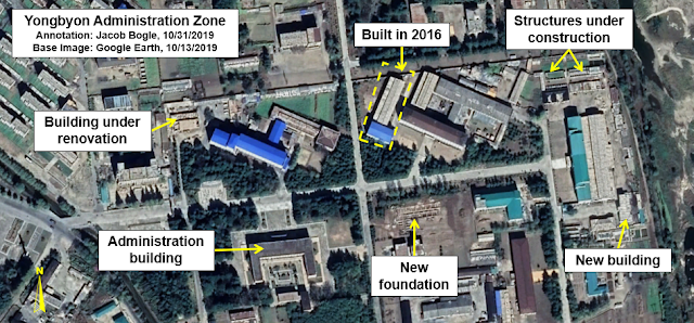
This next image shows changes to the primary administration and research zone. Multiple structures are in the process of being constructed and at least one appears to be undergoing some kind of renovation. I have also highlighted an addition to a research facility that was built in 2016.


To the immediate north, two new structures can be seen next to the IRT-2000 research reactor building. The reactor was provided by the Soviet Union in 1965. The Soviets provided North Korea with a total of 42 kg of highly enriched uranium until 1990. Pyongyang has said that the reactor produces needed isotopes for medical research and treatments, but the reactor can also produce tritium for their weapon's program. By 2011, it was widely believed that the Soviet-supplied fuel had all been used. However, it is now suspected that the reactor is using domestically created fuel.

The garden has existed for many years and is part of the regime's mandate that military units, schools, factories, and pretty much everywhere else do their part to solve the country's food problem. The food could be eaten by those working there or it may be sold in markets to earn currency. Looking at all of Yongbyon, you'll find nearly every free space of land is being used for cultivation. If defector and witness reports are correct about major pollution, then any food grown here will also be contaminated. This echos problems seen at other nuclear-related facilities, such as the uranium mine and milling plant at Pyongsan.


Several changes can be seen at the Yongbyon reactor zone. A new office building was constructed, and two smaller support structures built. The heavy-lift crane site has also undergone significant changes.

The crane structure was first erected in 2011 as part of the construction of the experimental light water reactor. The long, angular structure could be warehouses or contain a conveyor system. This was noted by 38 North and shows that the changes began in 2017 and continued into 2018.

While there are questions about the current operational nature of the reactors, the area has been very well maintained, had new construction, and stands ready to resume work whenever the orders are given.


Between the reactor zone and the nuclear fuel production zone lies a facility for maintenance and supplies. A large new building is currently under construction there. Its size and the visible structures inside suggest that it is likely an administration building to coordinate various construction and maintenance activities around Yongbyon.


The compound holding North Korea's uranium enrichment and nuclear fuel production center has likewise seen several additions.

Two small buildings have been constructed next to the enrichment facility, a building has been added to the isotope facility (lower right), and a building that had long appeared to have been abandoned has been repaired/reconstructed.

The new building at the lower right was pointed out in a 2018 report by 38 North.


Lastly there is some construction work happening right outside of a main security compound to the east. Two buildings are currently under construction (space for a third exists but no foundation work has begun). I don't know if the site is directly related to Yongbyon but it is extremely close to the electrified fence that surrounds the complex and is next to a key entrance point.


Not only is it possible to see that many changes have happened since 2016 (which, of course there would have been), but we can see that there are structures currently and actively being built. All of this points to an active city with a growing population, improved research and production capabilities, and is substantial evidence that North Korea isn't giving up on their nuclear program anytime soon. The continued mining and milling of uranium at Pyongsan, the fact that almost every building along the 17-km stretch of Punggye-ri still stands, and new progress toward creating submarine-launched ballistic missiles paints a picture very different than the one promoted by various media and political outlets.

Handshakes, signatures on paper, and hope all must give way to what is actually happening on the ground. And what is happening on the ground is telling.


This report also speaks to the ongoing need for continuing updates to Google Earth and other freely accessible products that give access to satellite images of the globe. Buying enough commercial imagery to cover all of Yongbyon can run into the thousands of dollars and places restrictions on research. While commercial entities enable individuals and news and research organizations to look at very recent images of specific sites, which does provide immense value, it also places limits on more comprehensive research into larger areas and often means that a good deal of North Korea gets overlooked.
However, so long as Google Earth (and even general map providers like Bing) continue to provide the world with their services, the democratization of research can continue. Be it looking into North Korea, changes to the Amazon rain forest, new internment camps in China, or the agricultural outputs of France, the world relies on open access to information.


I would like to thank my current Patreon supporters: Kbechs87, GreatPoppo, and Planefag.

--Jacob Bogle 11/1/2019
Patreon.com/accessdprk
JacobBogle.com
Facebook.com/accessdprk
Twitter.com/JacobBogle

Friday, July 7, 2017

International Friendship Exhibition Expands

Entrance to the Kim Il-sung Exhibition Hall. Source: Commons/TF92.

New excavation activity has been spotted at one of North Korea's largest museums. The International Friendship Exhibition is a massive underground complex in Myohyangsan, North Pyongan Province that houses vast stores of gifts and artifacts relating to the lives of Kim Il-sung, Kim Jong-il, and now Kim Jong-un. The exhibition is a major tourist destination and pilgrimage site for foreigners and North Korean citizens respectively.

It was constructed in 1978 among Myohyang Mountain (Mysterious Fragrant Mountain) which is the alleged home of King Tangun - the legendary father of the Korean people. This location helps to solidify the Kim's regime claim to be the rightful rulers, not just of the north, but of all Koreans; similar to the implication of the claim that Kim Jong-un was born on Mt. Paektu, which is the spiritual birthplace of the Korean people. Surrounded by centuries old temples and religious hermitages, as well as the mystical significance of the area, this museum to the legitimacy and "global importance" of the atheistic and communist Kim family takes up as much as 70,000 square meters (753,000 square feet) of space - much of which has been cut deeply into a mountain side - and contains upwards of 220,000 gifts.

Now that Kim Jong-un is the ruler, gifts to him (including such mundane things as an iPad and Lenovo desktop PC) need their own space within this complex, and satellite images now show increasing activity at the site.

(Note: to examine images more closely, simply click on them.)


In the above image you can see the three main external buildings as well as the two areas of recent excavation activity. The horizontal distance between the two sites is approx. 530 meters (1,738 ft).

Here is a close up of the upper site as seen on Oct. 8, 2016. Traces of old spoils/debris can be seen as well as the original underground entrance to the excavation areas within the mountain.


The trail of newly dumped material extends for some 110 m (360 feet) from the entrance as seen in this image dated May 7, 2017.


In this larger view of the lower area of activity, you can also see an older dump site of previously excavated materials. The site's hardened electrical substation is also visible.


Finally, this comparison close-up image of the lower site clearly shows the activity underway.


As I wrote about in 2015, a new runway was constructed at the site to ensure ease of access. Additionally, the nearby and mysterious Hagap site has also had activity resume as of 2016.

--Jacob Bogle 7/7/17
JacobBogle.com
Facebook.com/JacobBogle
Twitter.com/JacobBogle

Tuesday, July 4, 2017

North Korea by the Numbers


Phase II of the #AccessDPRK Mapping Project was published on March 5, 2017, but simply knowing where everything is doesn't make understanding the full picture much easier - especially when considering there's over 50,000 places marked. So I've put together these basic charts showing the total number of items per division (monuments, military, and domestic), the total items per province, and the total number of items within each type mapped (AAA sites, elite compounds, dams, communication centers, schools, etc.).

I'd like to point out that the overall figures here will differ slightly form the ones listed in the March 5th publication article. All told, there are some 600 individual sub-folders I have to keep track of and the resulting numbers take up 24 pages; minor mistakes happen. A couple numbers were inverted, and a few others were slightly off, however the overall discrepancies are very minor when compared with the whole. After making those needed corrections, the information below should be considered as authoritative as it will get with regards to the project.

The following charts (monuments, military, and domestic) represents the most detailed map of North Korea ever released to the public.


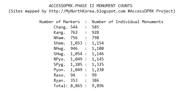
Many monuments are clustered closely together, making marking each one individually impractical. Instead, some markers are placed next to a group of monuments (2-4 generally), so while Pyongyang may have 1,049 markers on the map, those markers represent 1,230 individual monuments.

It's important to note, for those unfamiliar with the project, that the numbers below represent the numbers within the various folders by those names. There will be some items where there will only be one or two places within a province - those didn't necessitate their own folders. In such cases, they're often located in the "un-categorized" folder. An example of this is military training centers and military factories. Just about every province has at least one, but only a few have a folder dedicated to them.  A similar situation exists within the domestic file; bunkers, water towers, jails, and others may or may not have their own folder, but they will all be mapped.


While the purpose of this project is to map every one of a particular item, there are some items that I did not intend on mapping each and every one of, such as "firing positions". These trenches and prepared (but empty) gun positions cover the country and number in the thousands. In many cases it's also difficult to determine whether or not something was just a leftover temporary fortification from the Korean War or is part of the country's current defense structure (which does include having trenches in just about every available space). Additionally, the "radar" count is predominantly stand-alone radar sites, not the numerous smaller radars that accompany permanent artillery positions; although some of those are mapped as well. "Gates" are only mapped when they help define the boundaries of an area or are large - there's no real need to map every single gate at every single military site.

With the exception of a few items: canals, signs, factories and farming (to a degree), mountaintop sites, gates, and water supply, I have tried to be as comprehensive as possible in mapping each and every one of the other sites. Regarding the number of factories and farming/agricultural facilities, I focused on only mapping the larger sites, while also mapping some smaller agricultural facilities (like wheat threshing sites) to provide examples of what those numerous places look like. 

In short, the map contains 8,865 monument markers (representing 9,896 individual monuments), 9,594 military sites, and 35,252 domestic and economic sites for a total of 53,711 placemarks. There are also hundreds of fences and other things outlined in the map, but those aren't included in the counts as the places fenced in have already been accounted for.

#AccessDPRK will occasionally be updated to provide greater accuracy as new information comes in, fixing any unintentional errors, and adding more details.


--Jacob Bogle 7/4/17
JacobBogle.com
Facebook.com/JacobBogle
Twitter.com/JacobBogle

Sunday, April 2, 2017

Recovery Moves Along After 2016 Floods

Between August and September 2016, floods ravaged the northern reaches of North Korea. As I wrote about in December, satellite images showed us the devastation caused by these floods which affected over half a million people.

I'd like to now discuss the satellite images showing the recovery process. These images taken on October 25, 2016, focus on the hard-hit city of Hoeryong, North Hamgyong Province.

Image of the flood damage along the river. Google Earth, 9/14/16.

Dyke reconstruction work. Google Earth, 10/25/16.

Reporting coming out of North Korea claim that over a kilometer of dykes has been fully repaired.

In this next image we see new housing being constructed.

Image source: Google Earth, 10/25/16.

This is the DPRK/China border crossing. It received only minor damage, but you can see repair efforts under way as well as trucks coming in from China with relief and construction supplies.
The repair of this border crossing comes after North Korea constructed a new border crossing in Rason (which will be the subject of my next post).

Image source: Google Earth, 10/25/16.

Annual floods cause a fair amount of destruction and death in North Korea, but the northern provinces are often the most badly hit. UNICEF sent aid (including $1 million from the US) to help children and families affected by last year's flood.

-- Jacob Bogle, 4/2/2017
www.JacobBogle.com
Facebook.com/JacobBogle
Twitter.com/JacobBogle - Use the hashtag #AccessDPRK to join the conversation!

Sunday, March 5, 2017

Phase II Map Completed


One year ago today I published Phase I of my #AccessDPRK Mapping Project. I began mapping North Korea in late 2012, little did I know how much of an effort it would take or how expansive a map would result from the over 2,500 hours of work. I won't recount why I started, you can read more about that here, but I do want to stress that this map has become the largest and most comprehensive map of North Korea publicly available, by far.

The Google Earth file contains 53,722 placemarks covering three main areas of interest: the military, monuments, and domestic/economic sites. There are 9,567 military sites, 8,859 monument markers representing 9,879 individual monuments, and 35,296 domestic sites. Because I started mapping after I discovered Curtis Melvin's map and because I updated and incorporated his North Korea Uncovered into mine, I would like to say that of the 53,722 places, 8,430 of them came from North Korea Uncovered.

The file is divided according to each province and each province is divided into those three main areas (some have an extra division). Those three divisions are further sub-divided into item-specific folders (anti-aircraft artillery, dams, palaces, etc.). Typically, the military division has around 20 folders and the domestic division has around 40. The monument division is just a single folder containing all of the monuments in its respective province. There is also an "Additional Items" folder that has things like all the country's airports and a list of mountains. And, there is a file dedicated to the De-Militarized Zone with 1,401 places marked.

Because of the size of the KMZ file (4.76 MB - which is huge by Google Earth terms), don't try to view the whole thing at once. Expand the file and pick out which province you'd like to review and then what item folders you want. There are many ways to explore the information within, just take a little time to get used to the layout so you don't accidentally crash Google Earth (although, most modern computers can handle having the entire file open, it may be sluggish).

The next part of #AccessDPRK is to create a series of topic-specific files. For example, the country's electrical grid. This will allow those with narrower interests to view the information they want without the need to dig through mountains of data. However, there is no firm time set for me to build and publish those maps. After working on this for so long, I'm in the mood to take things more slowly now.

Map showing every monument in North Korea. Click for larger view (opens in new window).

[Note: the download link to the 2017 map has been removed as the 2021 version was made available.]

Below is a breakdown of the number of items per province and other main folders. As soon as I can I will also add some graphics showing how many of each item there are (like the fact there's active 1,539 anti-aircraft artillery batteries).


Phase II Complete Item Counts - March 5, 2017

Chagang Province = 2,695
   Military: 162
   Monument: 544 markers rep. 585 monuments
   Domestic: 1,989

Kangwon Province = 4,443
   Military: 1,131
   Monument: 762 markers rep. 928 monuments
   Domestic: 2,550

N. Hamgyong Province = 4,690
   Military: 450
   Monument: 765 markers rep. 796 monuments
   Domestic: 3,475

S. Hamgyong Province = 6,300
   Military: 627
   Monument: 1,053 markers rep. 1,154 monuments
   Domestic: 4,620

N. Hwanghae Province = 5,833
   Military: 1,347
   Monument: 946 markers rep. 1,100 monuments
   Domestic: 3,540

S. Hwanghae Province = 6,304
   Military: 1,008
   Monument: 1,054 markers rep. 1,146 monuments
   Domestic: 4,242

N. Pyongan Province = 5,581
   Military: 716
   Monument: 1,049 markers rep. 1,145 monuments
   Domestic: 3,816

S. Pyongan Province = 7,002
   Military: 1,134
   Monument: 1,205 markers rep. 1,325 monuments
   Domestic: 4,663

Pyongyang District = 6,150
   Military: 1,129
   Monument: 1,049 markers rep. 1,230 monuments
   Water supply: 290
   Domestic: 3,682

Rason District = 531
   Military: 42
   Monument: 94 markers rep. 99 monuments
   Domestic: 395

Ryanggang Province = 2,183 total
   Military: 95
   Monument: 338 markers rep. 371 monuments
   Domestic: 1,626
   Mt. Paektu: 126 - inc. 2 duplicates not inc. in counts elsewhere

DMZ-area Road Blocks: 198
DMZ: 1,401 + 394 miles of fence
Tall Mountains: 245
Airports: 127 (108 runways and 19 waypoints)
UN Joint Security Area: 5
Border Crossings: 24
Large intersections: 10


**********Grand Totals**********
Grand Total: 53,722 markers
   Military: 8,201 + DMZ/RBs/Airports = 9,567
   Monuments: 8,859 markers representing 9,879 monuments
   Domestic (inc. Border/Intersections/Mts) = 35,296


NOTE: AccessDPRK maps, articles, or other creations may not be used for commercial purposes without the express authorization of Jacob Bogle.


--Jacob Bogle, 3/5/17
www.JacobBogle.com
Facebook.com/JacobBogle
Twitter.com/JacobBogle

Wednesday, September 7, 2016

New Missile Test & Mapping Update

With Phase I having been published around 6 months ago and the recent mid-range ballistic missile test on Sept. 5, I figured I should give an update on where Phase II stands.

I'd like to quickly touch on the missile tests. According to CNN, the tests were carried out in Hwangju County, North Hwanghae Province (25 miles south of Pyongyang center). Korean Central Television released a YouTube video of the missiles being fired. In the video, you can see that the missiles were fired from mobile launchers positioned on a major highway with a highway tunnel in the background. In another scene a cell or radio tower is also visible.


Given the positioning of the camera, it's difficult to really gauge how far away the tunnel is from the launchers, however you can see a "turn around" spot near the tunnel and a bit farther back toward the launchers, you can see a section of pavement that looks a bit darker than the rest. This is typical of bridges. There's only one highway section that features all of these things near Hwangju.


So, this stretch of highway would seem to be the most likely location of the tests. Hwangju is also the home of the Third Air Combat Command which is responsible for the defense of the DMZ and southern portions of the country, which means they would have access to ballistic missiles. Additionally (whether or not these missiles came from here), the hills around Hwangju are filled with tunnels, hardened artillery sites, military units, and military storage facilities. That said, I cant't find any section of highway in the entire province that seems to look exactly like the video footage.

Mapping Update

As I mentioned in the Phase I release post, Phase II (which I'm working on now) will include a map of all the schools, town halls, "Palace's of Culture" (Juche study halls), and other buildings of interest in the country. I started mapping these places part-way into Phase I, meaning that I had to go over the rest of the country another time to get all the sites I hadn't originally marked.

The blue dots cover all the areas I have had to re-map (which adds up to roughly half of the country). In addition, I decided to go over Pyongyang entirely for a second time because of how dense the city is. My goal in all of this is to not miss greater than 10% of any given type of item (cell towers, schools etc) nationwide.


The Google Earth file size for Phase I is 2.7 MB and contains over 28,000 places. The current Phase II file adds a further megabyte, and I'm not even finished working on it! The file for Pyongyang itself has nearly doubled in size.

To help make the project of greater use to people, I have been scouring different sources for additional information on the various sites I've marked. If the name of a school is known, I want that placemark to be given the school's name. If a fancy looking new building pops up, I want to be able to tell you what it is, and so forth. Since I began this project over 3 years ago, I have also gone back through some of the folders and updated them, better categorized some places (particularly military sites), and worked to make everything uniform in terms of descriptions and the icons used.

The work for Phase II really comprises two parts: the first part is all the new mapping I'm doing, the second part is taking Curtis Melvin's North Korea Uncovered file (which is now over 7 years old) and updating any changes that have happened to the 8,100 sites he mapped. This also includes making corrections to places that were incorrectly identified (there aren't many, but accuracy is important) as well as fixing a problem created by Google Earth itself.

When Google Earth has updated imagery added, sometimes the coordinates don't mesh perfectly and, particularly in South Hwanghae Province, around 2006 the coordinate system was adjusted. The practical meaning is that many of the places marked there by Curtis are now off by as much as 1,000 feet. So I need to go through all of them and move them to their "corrected" positions. Oh, and I have to do the same for the large military-focused file created by Google Earth user "Planeman_"  and then collate his and Melvin's files because each project, while largely covering the same places, did map out some spots the other person missed. All of this adds up to a mountain of work.

The work of Phase I was completed in Nov. 2015 and released in March 2016. Since then, I have been able to go over nearly all the places I needed to. I only have about 20% of Pyongyang left. I have also already gone through thousands of sites marked by Melvin and Planeman_, though there is still much work remaining on that front. Some of the cool things that my comprehensive map will be able to bring to the general public is: 24 surface-to-air missile sites previously un-mapped by the earlier projects, the entire network of cell towers (very few existed during the time Melvin was working on his project), an updated map of their missile testing sites, more detailed maps of various palaces, a much more detailed map of Pyongyang with hundreds of buildings marked, and lots of added bits of information on countless other sites (including nuclear facilities).

I have a two week international vacation coming up soon and then of course the holidays are getting closer and closer, but I am really hoping to be able to have my Phase II mapping completed, the corrections/updates made to North Korea Uncovered, and the combining of Phase II, NKU, and Planeman_'s projects into a single master file with no duplicates and as few holes as possible by the end of 2016, if not sooner.

I'd like to thank everyone for their continuing support and patience. This has turned into a major project that has required thousands of hours of work and research. I hope it will be useful and live up to expectations once completed.

--Jacob Bogle, 9/7/2016
www.JacobBogle.com
Facebook.com/JacobBogle
Twitter.com/JacobBogle

Saturday, March 5, 2016

Phase 1 Map Complete!

AccessDPRK Phase I Release


Three and a half years ago I embarked on the ambitious project of mapping the whole of North Korea; a project called "AccessDPRK". I have always had a fascination with authoritarian regimes and for some reason my specific interest in North Korea began to grow a little over three years ago. I also have had a deep love of maps and geography since I was a very young child.

As my interests piqued, I started using Google Earth to look at North Korea. What I found were informative “community placemarks” marking the location of a monument or military site. I looked into who had created those placemarks, which seemed to cover the entire country, and found that they were part of a project called “North Korea Uncovered”. Created over the course of two years (2007-09), by George Mason doctoral candidate Curtis Melvin and a few volunteers, the project created the most comprehensive map of the country to-date. It included thousands of placemarks (approx. 9,000) – monuments, factories, palaces, artillery batteries, ancient tombs, and so much more. There was also another person, a Google Earth user known only as “Planeman_”, who created a map of supposedly all the artillery sites in North Korea.

However, as I explored these large files, I quickly discovered that there were massive holes in the data. While they marked some locations of each general type of item, the resulting creation was far from truly comprehensive. For some reason this offended me (in a lighthearted way), and since I am slightly obsessive and had an inherent interest in the country, I decided to take it upon myself to make the most comprehensive (at its fullest meaning) map of North Korea any private citizen has ever made by going and marking all of the locations not marked in Melvin’s project.

Once completed, I would release the information in the form of a Google Earth file to the public via my website, blog, and the Google Earth Forum. The goal being to expose the entirety of country to the world. To show people not just how the physical infrastructure of the nation is laid out (like power plants), but to also give a glimpse of daily life by having marketplaces, parks, as well as historical locations lost to Western knowledge, and much, much more. After the completion of “Phase I”, I also intend to review Curtis Melvin’s file and make any necessary corrections to it (since it is now six years old) and combine the two projects into a single “master file”. Little did I know what this full endeavor would require.

On Nov. 28, 2015, I finished the initial mapping phase of my project. After three years, over a thousand hours of active mapping work, and delving into thousands of pages worth of material to assist in creating this map, I now have seen every square mile of the country – indeed every home. The resulting Google Earth file is nearly 3 times the size of Melvin’s and contains 28,164 additional placemarks.

The file is divided according to each of North Korea’s primary administrative regions. Each is then further divided into 3 main categories: Military, Monuments, and Domestic. The Military and Domestic categories are subdivided into several sub-categories, such has anti-aircraft artillery sites, military bases, naval sites, and on the domestic side, dams, electrical substations, schools, factories, etc. All told, there are over 50 subcategories. Beyond those province specific folders, there’s are folders exclusively dedicated to the Demilitarized Zone, the country’s airports, historic places, etc.

One reason why this has taken so long is that as I would go around the country, I would find new categories of places that were numerous enough to have a national impact, like irrigation pumping stations and radar sites. So as I would add these new categories, I would have to go back an re-map formerly "completed" areas. 

The ultimate end of this project is not yet known. Like the development of the Internet, I’m not fully aware of the possibilities that can arise once people start mining the data. You could create a comprehensive map of North Korea’s electrical grid, you could discover their current defensive military strategies and find holes in their air defense system, you could work out how their internal security system is integrated across various transportation modes, and I’m sure many other things.

In addition to mapping, I’ve also written dozens of posts for this blog as well as 6 Wikipedia articles which have been read a combined 400,000 times and translated into multiple languages.
My main wish is that this can be used to help the world see that North Koreans are normal human beings who have been held hostage by their government. And that this provides some insight into how that government works to further the work of others in opening up North Korea, and one-day help bring North Korea into the 21st century with a respect for freedom.

Phase II is already underway, and I have marked over 5,000 new places thus far. These include public schools, universities, museums, theaters, town halls, and other "buildings of interest". This is going to take some time to complete, but I'm hoping to have everything (including the "master file") finished and ready to be published by the end of the year, if not sooner. 

Here are a few specific item counts:
Anti-aircraft artillery batteries: 587    Hardened Artillery Sites: 626    Military bases: 938    Monuments: 6,720   Dams: 1,169   Communication towers: 747   Electrical substations: 736
Factories: 470    Marketplaces: 225    Ancient sites: 112


Get the File!

If you want to discuss the project on social media, please use the hashtag #AccessDPRK either on Twitter or Facebook. I welcome comments and suggestions, as well as new information.

To access the Phase I Google Earth file, you can either visit my file archive here and click the download button for "AccessDPRK Phase I_Finish_V1-March-5-2016.kmz" or download it directly by clicking this link. To view the file you must have Google Earth on your computer/device. NOTE: this is a large file (over 28,000 items). For some computers Google Earth might freeze or crash if you try to have every province open at once. Just go through them one by one if you're unsure. 

All Google Earth KMZ files relating to this mapping project are hosted on my Google Site https://sites.google.com/site/mymappingprojects/access-north-korea


-- Jacob Bogle, 3/5/2016

Thursday, August 15, 2013

North Korea and Satellite Resolution

Google Earth pools data from many sources, weather satellites, public imaging satellites, and aerial photography, and often the information between each source is years apart. This leads to a wide variety of resolutions (0.5 meter to 2.5 m plus) and quality.

These resolution variances offer an interesting obstacle when it comes to mapping North Korea. Some of the images are merely days old with resolutions of such quality you can make out individual windows and see people walking in the streets.

(This image is about 750 feet wide)

And then there are other regions, mostly from France's National Centre for Space Studies (CNES) SPOT satellite, where the resolution is measured in meters. At this resolution you can only make out large structures, like the outline of houses.

(This image spans more than 2,500 feet)

Given the low resolution of the SPOT images, it can be almost impossible to definitively label something. Attempting to interpret an image is pointless in most cases. So, to help keep me (and others) from spending so much time scanning around trying to find an area of higher resolution, I've mapped out all of the larger low-res regions. Surprisingly, they make up a decent chunk of the country.


Once I've gone through the better quality regions, I will go over these low-res areas and mark whatever items I can find. You can download this file here.

Just for fun, I'm going to provide several examples of the different resolutions, colors, and seasons that one can find while exploring North Korea.

This is Pukchong, South Hamgyong. It is split between SPOT imaging and higher resolution images.

A town during winter

From MapABC, a Chinese company. Notice the poor coloration.

The same area in 2010 from Digital Globe 

Battle of Pochonbo Monument

Monument closeup 

A forest

And this is an example of what I call "foggy" imagery. I don't know what causes it, but it has nothing to do with actual fog/smog etc. It annoys me to no end because it makes it difficult to pick out certain features, like monuments or propaganda signs. Plus, it's just rough on the eyes.


--Jacob Bogle, 8/15/2013
www.JacobBogle.com
Facebook.com/JacobBogle
Twitter.com/JacobBogle