Access to the various palaces and villas around the country is provided by relatively short runs of roadway - a few kilometers or so - coming off of the local road network. But there is also a highway that runs nearly the entire length of a province that is dedicated to providing transportation between two palaces: Changsong and Hyangsan.

Starting in the early 1990s, a 116 km-long and tree-lined highway was constructed over the course of about three years.
The highway begins at National Highway 65, just south of the town of Hyangsan. From there, it goes west, winding its way through forested hills and low mountains, until it reaches the Changsong Palace complex on the Chinese border. The villas at Hyangsan are accessible from NH65 and are approximately 20 km from the on-ramp to the palace highway.
Unlike civilian roads, the highway is only sparsely connected to local road networks with intersections. I was able to locate a total of 14 intersections, but several of them are actually part of the palace highway to enable Kim's motorcade to bypass tunnels in the event one collapses or is otherwise blocked. And at least one intersection is simply for a small access road to a military base.

What also became apparent while looking for intersections, is that the highway was built over the path an older road which connected the northern parts of North Pyongan Province. Now, that older road is highly fragmented, with parts being completely disused. And the locals are largely left with winding dirt paths instead of a paved highway.

The palace highway is also connected to the Kim's leadership rail network through another road that leads from the Obong-ri Leadership Train Station (40.305346° 125.205669°), north of the town of Taegwan. The station itself was constructed ca. 1990-91 and a road leads from the station and connects to the main highway 12 km away.
The Obong-ri Leadership Station is unique among the two dozen or so other leadership train stations because it also contains an underground support facility.
It's impossible to go anywhere in North Korea and not be near some kind of military installation, but as an aside, I do think it's worth noting that the highway runs within 5 km of the Unsal MOUT (military operations on urbanized terrain) training complex which is the largest in the country, two other large bases, and the Taegwan Ballistic Missile Base.
In light of Kim Jong Un's penchant for flying and building runways at his favored palaces, one might ask why the highway was built at all when Kim Jong Il could have simply opted to fly, like Kim Jong Un has. Well, Kim Jong Il was terrified of flying. So, he only ever took trains and motorcades; flying only when absolutely necessary (the last time I'm aware of a flight was back in 1965).
And so, it makes a lot of sense that he would have invested in having a dedicated road built to connect two of the Kim's most enjoyed getaways.
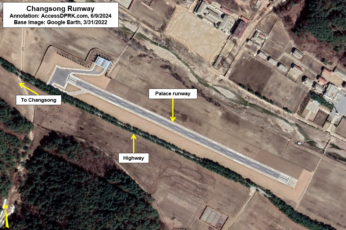
Since Kim Jong Un does seem to prefer to fly, with a runway at Changsong and helipads at both Changsong and Hyangsan, it is unclear whether or not the highway plays the same role as it did during his father's life. Occasionally, some of the intersections appear to be blocked off, and there aren't examples of normal traffic flow. So the highway is still restricted, but it may be getting a lot less use than in the past.
The highway is yet another example of the Kim family treating the resources of North Korea as their own personal property by destroying civilian infrastructure in order to build a private road that will have used a tremendous amount of resources that could have otherwise been used to help the people.
I would like to thank my current Patreon supporters who help make all of this possible: Alex Kleinman, David M., Amanda Oh, Donald Pierce, Dylan D, Joe Bishop-Henchman, Jonathan J, Joel Parish, John Pike, Kbechs87, Russ Johnson, Yong H.