I have written about different forms of land use in North Korea before; how the new border fence system affects local farming, the development of land reclamation projects, and even highlighted some of North Korea's green energy projects.

While making broad classifications of land use (forest, rice crops, urban environments) can be straightforward and can also be assessed using multispectral imagery, getting a more granular understanding, however, is often something that requires substantial human judgement.
Understanding land division in North Korea requires a lot of observation. Field boundaries are often based around tree lines, roads, rivers or irrigation canals, and are rarely neatly delineated with fencing or walls. And even when fences are used, being able to identify and trace them can be difficult.
A great example of that can be found at the Yongbyon Nuclear Scientific Research Center.
When discussing Yongbyon, attention is rightly focused on the various nuclear-related facilities that are all clearly identifiable behind their perimeter walls. But Yongbyon is more than just the nuclear reactors and research facilities. Like many examples in the former Soviet Union, Yongbyon is a closed city. It is made up of the town of Dong-an and has several small villages within a much wider perimeter fence that encloses nearly 25 sq. km. of territory.

Indeed, even places like the Punggye-ri nuclear test site and the adjacent Hwasong political prison camp (kwan-li-so No. 16) rely on their remote location as much as any fence system or guard posts to secure their territories. If kilometers of fence exist around the mountain that nuclear devices are tested beneath, I certainly haven't found it.
But, back to the title of this post, Pyongyang: Air Defense by the Hectare. This will be the first of what will become a series of articles detailing how much land in North Korea is being used by the military. It's one thing to know how many individual military bases there are, it's another to understand how they fit into the larger landscape of North Korea's territory and how much land is being used for purposes other than food production or economic and industrial activity, and even its impact on the natural environment.
All countries, of course, have the right to national defense. And that right obviously requires that land be used for military purposes. In the United States, 8.8 million acres of land are owned by the Department of Defense for the purposes of training and housing troops, testing weapons, and other directly related military uses. (This excludes land controlled by the Army Corps of Engineers which administers over 5,000 individual sites for public benefit like hydroelectric dams and recreational areas).
But that's only 0.39% of the total landmass of the US. Unlike the US, however, North Korea doesn't have vast deserts that it can use for testing nuclear weapons nor does it have an abundance of available farmland. So, I think it's worth exploring how being such a militarized country impacts North Korea's land use.
To start off the topic of military land use in North Korea, I'd like to examine the air defense sites within Pyongyang.

In 2022 I wrote about North Korea's expansive air defense network. With over 1,500 fixed-position installations made up of surface-to-air missile batteries and short-range anti-aircraft artillery sites, North Korea has the densest such network in the world that is currently operational.
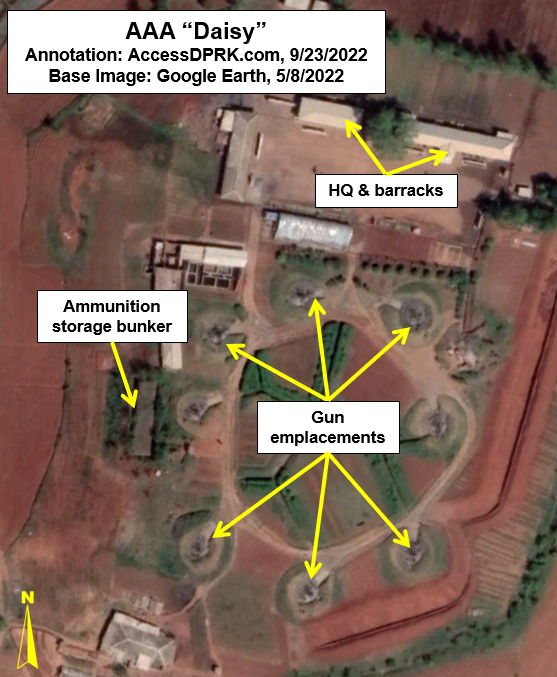
As the capital, Pyongyang naturally has the most protected air space. Eighteen surface-to-air missile (SAM) sites positioned within 60 km of Kim Il Sung Square provide overlapping coverage of the city. And over 400 short-range anti-aircraft artillery (AAA) sites form concentric rings of protection, with the Kim family palace having the most well-defended airspace of them all.
But directly inside of the Pyongyang capital administrative region, there are six SAMs and 243 independent AAAs (some SAM sites have their own AAA batteries to aid in their defense).
Both kinds of air defense systems are made up of permanent gun emplacements, barracks, munitions storage, fire control & communication, and maintenance facilities. Some also have their own radar installations.
A Note on Methodology
Determining the exact amount of land that is under the direct control of each unit isn't straightforward. Some air defense installations are compact and others sprawl out across the landscape. Some are located on mountaintops and others are in the middle of farmland. Some have clearly defined boundaries with perimeter fences and others require closer examination to assess their extent.
In cases where a SAM or AAA site, with all of its constituent structures, are nicely bound by fencing, measuring its total area is simple. For those sites without fencing, I tried to create area polygons that enclose the artillery/missile location, headquarters, and storage sites. Sometimes those sites can be 100-200 meters apart and may even be separated by irrigation canals or other topographic features. In such cases, I have endeavored to draw the areas conservatively, and to use trench networks, field boundaries, waterways, tree lines, roads, and other bounding features to help constrain the area into reasonable and contiguous plots that don't include large amounts of extra land.
That is particularly important because nearly all military facilities in North Korea also engage in agricultural activities. So a particular military unit may have control over multiple hectares of farmland, but that land may extend for hundreds of meters away from the core air defense structures. It's also less obvious what bit of farmland belongs to the artillery unit as part of farming compared to the land that is part of the direct operation of that unit's military purpose. Thus, only land that is either bounded directly by a clear perimeter or is immediately adjacent to the various military structures have been included in this survey.
Surface-to-Air Missile Sites

Given their limited number, SAMs don't take much land overall. Together, the six SAMs within Pyongyang occupy a total of 52.6 ha (130 acres). Two of them are also located on top of hills or mountains, with one being positioned on the top of Mt. Taebo (38.988250° 125.583587°) at an elevation of nearly 372 m (1,232 ft), making their impact on available farmland even more limited.

However, the other four are in areas that would otherwise be used for more productive purposes, including the SAM located amongst the village of Kumdae-ri (38.937404° 125.628269°), south of the Taedong River.
The six SAMs are SA-3 (S-125) systems dating to the 1970s and are of questionable serviceability. Nonetheless, the sites continue to be manned.
Anti-Aircraft Artillery Sites

Pyongyang's 243 AAAs take up a total of 716.2 ha (1,770 acres) and are located on every kind of terrain around the city.
As I discussed in 2022, each AAA has between one and twelve artillery pieces (such as the M-1983 Quad 14.5 mm gun and ZU-23-2 twin barrel autocannon), with most having 6-8 guns.
The smallest sites are single gun emplacements along the rim of a large water settlement basin in eastern Pyongyang and each occupy around 500 sq. meters of space. The largest is a dual set of AAAs that share 12.2 ha (30.3 acres). On average, however, each AAA location covers 2.94 ha (7.28 acres).
Some are on mountain tops and others defend palaces or are part of larger military areas. Most are located in the low hills and plains that stretch out before Pyongyang, disrupting the networks of farms that help feed the capital.

The aforementioned village of Kumdae-ri is surrounded by seven AAAs within 1.3 km along with the SAM battery.
Most are also denuded of any tree cover. A portion of the land within each AAA site is still used for agriculture, but that is because of long-standing orders requiring military units to become as "self-reliant" as possible. Official rations are barely sufficient and so soldiers spend much of their time as farmers, working to feed themselves since the state cannot provide enough calories on its own, reflecting the severity of North Korea's food crisis.
The number of AAA sites varies more often over time than do SAM batteries. AccessDPRK has located over 100 former AAA sites within Pyongyang. And eight active AAAs have been built since 2016.
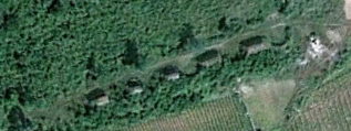
Of the former sites, some have been completely demolished and leveled, making way for crops, houses, and factories. But many others retain their revetments and abandoned bunkers, making their complete reclamation for productive, civilian uses more difficult.
Pollution
Military "brownfield" sites, developed land that has been abandoned or underused, come with numerous special environmental considerations when converting them to other uses - especially for agriculture.
After decades of use, the artillery installations can be contaminated by accumulated heavy metal toxins, scrap metal, lead, diesel, oil and other petro-based chemicals used in the maintenance of equipment and vehicles, as well as untreated human waste (given the historically poor state of sewage transportation, treatment, and disposal in North Korea).
There is little satellite evidence and no eyewitness testimony to suggest that detailed contamination remediation efforts occur prior to these sites being reused for farming or home construction. Indeed, many of the sites that have been fully removed appear to have simply been leveled and plowed under, with crops planted on the site soon after.
This assessment is supported by observing the six AAAs that were removed in 2016 on the grounds of the Taedonggang Combined Fruit Farm.


Without physically examining the sites it's impossible to determine the extent of the contamination and whether or not it impacts the quality of food grown over the land or if it affects ground water. But North Korean authorities have allowed far greater levels of pollution at others sites, and so it's doubtful that they place a high importance on former air defense units.
I would like to thank my current Patreon supporters who help make AccessDPRK possible: Donald Pearce, David M., Dylan D, Joe Bishop-Henchman, Joel Parish, John Pike, Jonathan J., Kbechs87, Raymond Ha, Russ Johnson, Squadfan, and Yong H.