Showing posts with label artillery. Show all posts

Saturday, September 24, 2022

In North Korea Thousands of Guns Point to the Sky

North Korea has the densest network of air defense sites in the world, and their mix of low-level anti-aircraft artillery (AAA) systems, Soviet-era surface-to-air missile (SAM) bases, and early warning radars still pose a risk to adversaries. 

An M-1983 Quad 14.5 mm anti-aircraft gun being shown during a parade in this undated image.

Between the AAA and SAM batteries, over 1,500 fixed air-defense sites are arrayed to protect North Korean airspace (squeezed into an area half the size of England). 

In this article I will focus on the current capabilities of the county's anti-aircraft artillery, but I'll also touch on their surface-to-air missiles as well.

Under the control of the KPA Air Defense Command and Pyongyang Antiaircraft Artillery Command, North Korea's AAA defense are made up of M-1983 Quad 14.5 mm guns, ZU-23-2 twin barrel autocannons, M-1992 Twin 30 mm autocannons, and M-1992 Twin 37 mm self-propelled guns.

These guns have a practical rate of fire of between 150 and 1,600 rounds per minute per barrel, with effective ranges of 2.5 to 5.8 km depending on which system is being used. 

AAA batteries are typically laid out in two arrangements, the "daisy" and what I call the "I".

Example of the "daisy" layout.

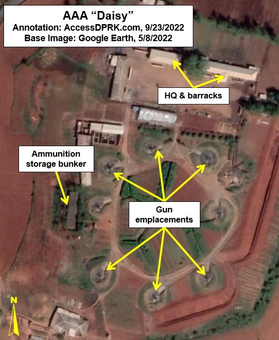
Daisy arrangements refer to a circular configuration of guns. They range in size from 4 to 12 guns and may form a "chain" of daisies, with 2-3 sets of four guns each or they may simply be a single circle of guns. 

According to George Herbert, adjunct professor at the James Martin Center for Nonproliferation Studies, AAA guns in this arrangement lie within a targeted environment (such as near the Yongbyon Nuclear Center) and can protect it from threats coming in from any direction.

Example of the "I" layout.

The second primary arrangement for AAA guns is "I". These are just a single straight line of guns. All but one of the "I" layout sites deploy 8 guns.

Mr. Herbert explains that this arrangement is best for firing at aircraft that still lie outside of the main target, such as on the approaches to Pyongyang, but before they actually enter the city's airspace, and can concentrate the fire from multiple guns onto the enemy aircraft.

There are 70 of these surrounding Pyongyang in an oval ring 25-30 km outside of downtown.


A Layered Defense

The country's air defense is constructed using a layered approach. The DMZ and each coast has a line of AAA batteries along them with the main coastal cities then being encircled by their own ring of defenses. Interspersed in other parts of the country are the batteries for major KPA bases, navy and air bases, missile sites, industrial centers, and key palaces. There are also a few others scattered around the country at seemingly random sites. 

Nowhere is this layered defense more obvious than at Pyongyang.

As the nation's capital city, Pyongyang is the largest population center, is where all of the main military command centers are located, and it contains the greatest concentration of industry making its capture a primary goal in any war.

Pyongyang has over 400 AAA batteries arrayed in three main lines of defense, and it is also protected by two outer rings of 19 surface-to-air missile batteries as well.

Illustrative map of the main AAA and SAM defensive ranges (approximate distances) around Pyongyang, with the Ryongsong Palace highlighted in blue. The yellow ring is the palace's dedicated air defense ring.

Within Pyongyang is also the Ryongsong Palace complex. Nestled within Pyongyang's air defense space, the palace is surrounded by its own dedicated ring of AAA batteries and is covered by at least 5 nearby SAM batteries, making the palace perhaps the most well-defended single site in the world.

Other areas that enjoy substantial air defense are Nampo, Sariwon, the Yongbyon Scientific Nuclear Research Center, Haeju, Kaesong, Wonsan (which is also home to a Kim palace), Hamhung, Kanggye, Chongjin, Tokchon, and the elite Samjiyon-Mt. Paektu area.


All of these overlapping clusters also end up creating a thicket of AAA sites within the "Kaesong-Munsan" invasion corridor. This would be the most contested stretch of airspace as it is the most direct path from connecting the capitals of North and South Korea. The corridor is roughly 50 km wide and 155 km long, stretching from the DMZ up to Pyongyang. 

Map of invasion routes including the two Kaesong approaches. Image: Marine Corps Intelligence Activity, North Korea Country Handbook, May 1997.

In any given 5 km circle (the maximum range of most AAA guns) a pilot would only have three, perhaps four, brief moments where they weren't in range of any guns if they were flying through the center of the corridor. Of course, where AAA may not reach there are still the dozen+ SAM sites that lie within the corridor and whose ranges are between 25 and 300 km depending on the missile system being used.


Point to the Sky

Nationwide, North Korea currently has 1,463 active AAA sites. These batteries have the capacity to field 8,641 individual artillery pieces. Each battery consists of anywhere between a single gun to up to 12 guns. The majority fall in the 6-8 gun range. Not every fixed position has a gun in it at all times, but around 90% do. This means that at any given moment there are 7,777 artillery pieces ready to fire.

There are also 521 known decommissioned sites. Having decommissioned sites mapped is important, particularly within the public sphere, in order to have accurate maps available. Many of these older sites haven't been demolished, merely closed, and so they still look like they could be used. That has led to some of them being incorrectly identified as active on other databases (like OpenStreetMap and Wikimapia).

Additionally, knowing when sites are closed or newly constructed allows researchers to better track trends in air defense strategies (among other things).


Surface-to-Air Missiles

Map of current SAM positions.

The country also maintains between 57 and 61 surface-to-air missile batteries, with two of them being modern constructions. Most field S-25, S-75, and S-125 systems that are from the Soviet-era. North Korea has attempted to develop their own SAM systems with the KN-06 and KN-30 which are clones of Russian S-300 and S-400 SAMs. However, despite being promoted in official state media, these mobile systems haven't yet been verified to have been fully deployed through open-source imagery and publications.

If they are being used, they would most likely first be sent to the new SAM batteries constructed at Wonsan (39° 7'16.21"N 127°44'16.26"E) and near the town of Haeju (38° 5'28.79"N 125°27'2.18"E).

Between AAA and SAM sites, approximately 75% of all of North Korea's airspace is covered using conservative measurements. The largest gaps in coverage are in the highly mountainous border areas with China and access to those gaps would require either flying in from China or making it through already defended areas.


An updated explorable map of North Korea's air defense sites is available through purchase of the AccessDPRK Map (Pro Version)


I would like to thank my current Patreon supporters: Amanda O., GreatPoppo, Joel Parish, John Pike, Kbechs87, Russ Johnson, Squadfan, and ZS. 

--Jacob Bogle, 9/23/2022

Wednesday, August 30, 2017

North Korea's Sacrificial Islands

When North Korea isn't firing intermediate and long-range intercontinental ballistic missiles (ICBMs) from highways and hidden factories, they're firing hellish amounts of smaller artillery. For the past several years, some of the recipients of these displays of military might have been two small islands off the coast of Wonsan.

The islands of So (So-do) and Hwangto (Hwangto-do) have been pummeled multiple times. Most recently in April and August 2017, December 2016, and March 2016. This video, originally from the Korean Central News Agency, discusses the August drills and shows images of the islands.

English-dubbed Video Source: StimmeKoreas

Both islands lie off the Kalma Peninsula, which is where the Kalma Airport is located (North Korea's recently modernized airport). Kalma is also the site of two rocket launch pads and has seen at least one failed rocket test.

So Island is approx. 6.7 km east of the tip of Kalma (among a small group of islands) and, farther south, Hwangto Island is 2.45 km east of the beach. At the tip of the peninsula are several villas, a sanitarium, and a possible hotel.

(Click on images for larger view)


Without further ado, here are the island martyrs.

So Island has a more recent history. Prior to 2014, the island appears to have served as a small outpost, perhaps for local fisherman. It contained a few buildings on the western side, and the rest was left alone. The buildings were demolished in late 2014.


So Island is a mere 460 meters by 293 meters at its widest points. As noted earlier, So Island was the target of an artillery drill in December 2016. The image below shows the results of that barrage.


This is a picture from the Korean Central News Agency showing the island being hit during the 2017 drill. The large island seen the background is Sin-do.

Image Source: TheSun.co.uk

Next is Hwangto Island, which has a longer history of being a bombardment target.


Hwangto is slightly larger than So at 587 meters by 295 meters. In the image below, shelling damage can be seen from a drill that occurred not too long before May 17, 2011. There is also a small building that has been demolished. 


On both islands, the structures seem to have been manually demolished rather than destroyed as a result of artillery. 


The above image shows the various prepared firing positions along the beach at Kalma. These sites are angled to line up with the the target on Hwangto Island.

In this KCTV picture from April 2017, the firepower displayed is rather impressive. An estimated 400 pieces of artillery were used.


The below image is the most recent on Google Earth. Dated Dec. 8, 2016, you can see the damage done from additional artillery drills as well as a new target. That target was used during the April 2017 drill.


Thanks to the support of OpenDPRK, I can now show you the results of this recent onslaught. 


The largest craters are 10-13 meters in diameter. 

These displays of might happen a few times each year and usually coincide with major holidays or as a response to US-ROK drills. 

I wonder how many more artillery drills it will take before the cliffs at So Island collapse?


--Jacob Bogle, 8/30/2017
JacobBogle.com
Facebook.com/JacobBogle
Twitter.com/JacobBogle

Friday, April 10, 2015

Mapping Progress Update #6

It has been nearly a year since my last full update on my progress on mapping the whole of the country, and progress has been great.

A year ago, I had mapped 10,000 sq. miles, or 21.48% of the country and I had around 5,500 military, domestic, economic, and propaganda places marked. It took me around a year to get to that point (remembering of course that I wasn't doing this every single day, and I'm still not always able to work on this).

Today, I've mapped out 26,137 sq. miles (56.15%) of the country (which is 46,541 sq. mi. in size). Of that, 8,219 sq. mi. has been mapped just since the start of 2015. My productivity has greatly increased since I decided to set a completion date: Dec. 31, 2015. And that includes combining my finds with the extensive original work of NKeconomywatch and Google Earth user "Planeman_".

To finish this year, I need to map an avg. of 78 square miles a day. So far, I'm averaging 83. That places me 5 days ahead of schedule right now and puts me on target to finishing 20 days early by year's end. Of course, something could happen and my average rise or fall.

As noted in an earlier update, to help with effective mapping, I divided the country into sections covering (roughly) 25 square miles. This map shows each section that I have mapped. The elevation is set so that each dot is 5 miles in diameter, thus, mostly covering the areas I have fully mapped.

 
Click for larger view.

In terms of items marked: 18,657 total items; 3,221 military (inc. DMZ, Airports & Road Blocks), 4,140 monuments, and 11,103 domestic & economic locations. Here are the specific numbers for a few select items: 389 anti-aircraft batteries which represent about 1,900 individual guns, 327 communication/cell towers, 364 electrical substations, and 145 town markets. I've also mapped out hundreds of miles of new roads, main irrigation canals, coastal fences, and border fences.

Included under the "military" heading are, 461 additional places along the DMZ, 140 DMZ related road blocks, and 76 airports, heliports, and aviation test facilities (6 hadn't been located before).

I've also marked all 23 current and former border crossings, twenty of which connect with China. Plus, 159 key mountains & local geographic high points.

Here's a few images to give you an idea of what all I've mapped.

All 76 aviation facilities. Click for larger view.

Electrical Substations of North Pyongan Province. 

Cell towers of Pyongyang. 

North Hwanghae Province's Anti-Aircraft Artillery Sites.

The red dots represent HARTS (Hardened Artillery Sites) in South Hwanghae Province near the South Korean island of Yeonpyeong. On Nov. 23, 2010, North Korea bombed the South Korean island with 170 shells & rockets. Four were killed and 19 injured.


---Jacob Bogle, 4/10/15
Facebook.com/JacobBogle
Twitter.com/JacobBogle
www.JacobBogle.com

Sunday, April 28, 2013

New Military Constructions for Artillery

I was going about my business mapping North Korea when I came across an odd set of trenches, and then more of them and more. After looking at their design it became somewhat obvious that these were new hardened emplacements for artillery.

This map gives you a broad view to help you understand their location with respect to well-known cities and islands.


In all I found 21 new sites as well as 1-2 more in the process of construction. Some of the placemarks represent two sites which are side-by-side, in total there are 24 of these "tunnels."

Here is a close-up map of all of the new locations:


The one in the center of the group can be found at 37°48'23.31"N 125°28'5.17"E. All of the other ones are within 1.5 miles of the center.

They all have the same layout, a curved entrance with a "pad" in front and they're all dug into the sides of hills. This is a detailed image of several of them in a cluster.


Each entrance is 21-24 feet wide and from the entrance to the access road is around 100 feet. All of the access ramps are aligned so that the entrances are either facing the north or west.

Also, the area has had a fair amount of new construction with new roads and new buildings.

Here is the central region on Nov 25, 2011:


The same area except on June 20, 2012:


A close-up of some of the buildings:


And finally, a detailed image of the northern most region:


Based on the dates for the past imagery this entire project was built in less than a year. The location of this facility is less than 14 miles from Yeonpyeong Island, SK and less than 61 miles from Incheon International Airport and mainland South Korea.

This has been a rather unpleasant discovery.


--Jacob Bogle, 4/28/2013
www.JacobBogle.com
Facebook.com/JacobBogle
Twitter.com/JacobBogle

Saturday, April 27, 2013

Coastal Defenses

North Korea's coasts are littered with defensive positions, a hodgepodge collection of modern defenses mixed with those remaining from the Korean War.

Their design takes a layered approach and is dependent on the topography of the area. Naturally, locations closer to the DMZ and those along the eastern coast (facing the historical enemy of all Korea, Japan) are more built up. To the southwest, the land border between North and South Korea gives way to a series of river mouths and tidal inlets, most notably at the confluence of the Imjin and Han rivers. This area opens up to the sea and is where I consider the North Korean coast in this region to being.

Within 3 miles of the Northern Limit Line (the de facto maritime border between the two countries, although it is disputed) are a series of observation posts located along the river banks, fences to the rear of the posts, a number of sand berms which divide up the patty fields, successive layers of road blocks/tank traps, and mixed throughout are anti-aircraft artillery sites (AAA), gun lines, trenches dug into the hills, and hardened artillery sites (HARTS). There are also ammunition caches and other storage facilities dispersed throughout.

Here is a sample region.

(click images for larger view)

The Northern Limit Line runs in the middle of the river, naturally South Korea is to the south. The wider yellow line is the area I have marked as encompassing most of the border defenses which include the DMZ. It is approximately 3 miles (with some variation) from the NLL and the Military Demarcation Line which serves as the land border. The "P" icons are small position, observation posts etc. The red circles are HARTS positions, the "S" icons are storage facilities, "F" is for fortifications, the pink icon denotes bunkers or tunnels and the "policemen" mark road blocks of the type I discussed in this post

Here is an example of the sand berm and fence which runs the length of this region (as well as nearly all low-lying coastal areas).


To the north of this beach, in an area about 5 miles wide, there are 8 road blocks.


Now, moving away from the NLL here is a map of some of the small coastal positions located along the coast of South Hwanghae province. 


The island to the bottom right, labeled Keunyeonpyeong-do (also known as Yeonpyeongdo), is the South Korean island which was bombed by the North in 2010 which killed 4 and wounded 18 others. 

This is a close up of one of the larger positions. 


Literally thousands of miles worth of trenches can be found throughout the county. Some are left over from the Korean War and have no real use, but others are part of their active defenses. Like these:


Both east and west coasts are intermittently lined with obstacle courses aimed at preventing any rapid movement inland during an invasion. These "dragon's teeth" consist of row after row of concrete blocks which have been sunk into the sand. The rows, usually 10 running parallel to each other, make up a full "band" around 100 feet wide. Most of these were put in place decades ago, some have been removed and others still have simply been covered up with drifting sand and mud. Still, in some areas they would slow an advancing force. They tend to be found in low-lying areas which lack mountainous terrain within a few miles of the coast and they are often paired with road blocks and berms further inland as well as rows of berms along the beach itself.

In this example the obstacle band has been marked in red, you can see the multiple sand berms in nice little rows.


And a close-up of the dragon's teeth themselves:


Next is the defensive positions around a few coastal towns. If you look at the coastal defense map I gave you above, this area is roughly the 4 blue places marks in a cluster, to the north of Yeonpyeongdo Island. 


The blue lines are fences and the three red lines are the tank traps. As before, the red circles are HARTS, the blue marks are small positions, "G" is a gun line and "B" is a coastal battery.

Finally, these are just three additional images of some interesting coastal places:

An AAA site with trenches - 


A close-up of a hardened artillery site - 


And a reserve fleet of 10 ships. There are a number of these types of locations dotted around the coast. Some are just sitting in dry docks like these and others are actually housed in underground naval yards.


--Jacob Bogle, 4/27/2013

Monday, March 4, 2013

North Korean Artillery Sites

As I have mentioned before, North Korea is the most militarized country on Earth. They spend 20% of their GDP on their military (more than 5x higher than the US), males are required to spend 10 years in the military and at any given time 5-10% of their population is on active duty with an additional ~30% of the population in reserves or paramilitary units.

The country has successive layers of defensive positions, most notably around Pyongyang. This shows the location of many Anti-aircraft artillery sites (AAA) around Pyongyang and their ranges are shown by the circles.


One of the most common AAA platforms is the ZPU-4, pictured below.[1]

(Image source: Commons, CC 3.0)

This is just an example of the weapon and wasn't taken in the DPRK. It has a range of 8km.

There are currently between 1,500-2,000 AAA and HARTS (Hardened ARTillery Sites) sites in North Korea. Due to their economic difficulties and sanctions it is likely that 20-25% of the sites are non-functional (lack of parts, repair capability etc). Although it is very likely that the sites around the capitol and the DMZ are given priority and are functional.

While it is widely agreed that the technology and weaponry used by the DPRK is outdated and would offer little resistance to a full on assault by a modern military the fact that they retain such a vast number of guns and men under arms means that they represent a very real and credible conventional force.[2] Plus, they have special units trained in asymmetric warfare thus any land invasion would be an arduous and costly undertaking.

This realization and the ever-present reality that Seoul, South Korea lies within range of many of the North's weapon systems is why war cannot be considered as a series action. Should a war break out, within 48 hours it is estimated that South Korea could suffer 1 million casualties.[3]

There are two main layouts of their AAA sites and an asymmetrical layout. The most common is the "daisy" or "flower" design.


Here is a smaller version.


This is an example of a linear site. A number of traditionally "daisy" sites have been converted to linear sites.


An asymmetrical site. These are typically located along the thin ridges of low-lying hills or near populated areas lacking in uniform open spaces.


During the 1970's there were many more sites but over the years they have been removed or consolidated. I can only presume that it is because they lack the funding to keep all of them operational and that over the years many of the guns have broken beyond repair. This is one such site.


HARTS are largely a North Korean style of defense. They can take many forms but typically include AAA guns, SCUD missiles, SAM's, radar sites etc located in bunkers either cut into the side of a hill or in hardened facilities. Then they are rolled out into the open to be deployed. Some are also locations with gun positions cut into a hill or berm and are only covered by simple sheds. Although this might not sound all that secure the gun lines are very thin and are backup against a hill with tree cover. This presents a rather small target and depending on time of year they can be hidden rather well from aerial view.

Most of the artillery HARTS (HARTS can also be used to describe underground naval facilities and others) are located along the DMZ and there are 200-500 of them spread out along its 160 mile border. [4]


This is a typical position for the interior of the country.

And here is one typical of the DMZ. Note the small sheds.


Sources:
1. ZPU-4, Federation of American Scientists
2. North Korean Military, US Dept. of Defense
3. From Lambs to Lions, by Thomas Preston, pg 127
4. HARTS in North Korea, Nautilus Institute

Additional Reading:
Fortress North Korea, from GE user "Planeman_" at Militaryphotos.net
North Korea's WMD programs, Federation of American Scientists

--Jacob Bogle, 3/4/2013
www.JacobBogle.com
Facebook.com/JacobBogle
Twitter.com/JacobBogle