Saturday, March 5, 2016

Phase 1 Map Complete!

AccessDPRK Phase I Release


Three and a half years ago I embarked on the ambitious project of mapping the whole of North Korea; a project called "AccessDPRK". I have always had a fascination with authoritarian regimes and for some reason my specific interest in North Korea began to grow a little over three years ago. I also have had a deep love of maps and geography since I was a very young child.

As my interests piqued, I started using Google Earth to look at North Korea. What I found were informative “community placemarks” marking the location of a monument or military site. I looked into who had created those placemarks, which seemed to cover the entire country, and found that they were part of a project called “North Korea Uncovered”. Created over the course of two years (2007-09), by George Mason doctoral candidate Curtis Melvin and a few volunteers, the project created the most comprehensive map of the country to-date. It included thousands of placemarks (approx. 9,000) – monuments, factories, palaces, artillery batteries, ancient tombs, and so much more. There was also another person, a Google Earth user known only as “Planeman_”, who created a map of supposedly all the artillery sites in North Korea.

However, as I explored these large files, I quickly discovered that there were massive holes in the data. While they marked some locations of each general type of item, the resulting creation was far from truly comprehensive. For some reason this offended me (in a lighthearted way), and since I am slightly obsessive and had an inherent interest in the country, I decided to take it upon myself to make the most comprehensive (at its fullest meaning) map of North Korea any private citizen has ever made by going and marking all of the locations not marked in Melvin’s project.

Once completed, I would release the information in the form of a Google Earth file to the public via my website, blog, and the Google Earth Forum. The goal being to expose the entirety of country to the world. To show people not just how the physical infrastructure of the nation is laid out (like power plants), but to also give a glimpse of daily life by having marketplaces, parks, as well as historical locations lost to Western knowledge, and much, much more. After the completion of “Phase I”, I also intend to review Curtis Melvin’s file and make any necessary corrections to it (since it is now six years old) and combine the two projects into a single “master file”. Little did I know what this full endeavor would require.

On Nov. 28, 2015, I finished the initial mapping phase of my project. After three years, over a thousand hours of active mapping work, and delving into thousands of pages worth of material to assist in creating this map, I now have seen every square mile of the country – indeed every home. The resulting Google Earth file is nearly 3 times the size of Melvin’s and contains 28,164 additional placemarks.

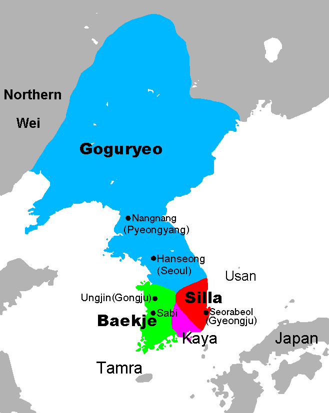
The file is divided according to each of North Korea’s primary administrative regions. Each is then further divided into 3 main categories: Military, Monuments, and Domestic. The Military and Domestic categories are subdivided into several sub-categories, such has anti-aircraft artillery sites, military bases, naval sites, and on the domestic side, dams, electrical substations, schools, factories, etc. All told, there are over 50 subcategories. Beyond those province specific folders, there’s are folders exclusively dedicated to the Demilitarized Zone, the country’s airports, historic places, etc.

One reason why this has taken so long is that as I would go around the country, I would find new categories of places that were numerous enough to have a national impact, like irrigation pumping stations and radar sites. So as I would add these new categories, I would have to go back an re-map formerly "completed" areas. 

The ultimate end of this project is not yet known. Like the development of the Internet, I’m not fully aware of the possibilities that can arise once people start mining the data. You could create a comprehensive map of North Korea’s electrical grid, you could discover their current defensive military strategies and find holes in their air defense system, you could work out how their internal security system is integrated across various transportation modes, and I’m sure many other things.

In addition to mapping, I’ve also written dozens of posts for this blog as well as 6 Wikipedia articles which have been read a combined 400,000 times and translated into multiple languages.
My main wish is that this can be used to help the world see that North Koreans are normal human beings who have been held hostage by their government. And that this provides some insight into how that government works to further the work of others in opening up North Korea, and one-day help bring North Korea into the 21st century with a respect for freedom.

Phase II is already underway, and I have marked over 5,000 new places thus far. These include public schools, universities, museums, theaters, town halls, and other "buildings of interest". This is going to take some time to complete, but I'm hoping to have everything (including the "master file") finished and ready to be published by the end of the year, if not sooner. 

Here are a few specific item counts:
Anti-aircraft artillery batteries: 587    Hardened Artillery Sites: 626    Military bases: 938    Monuments: 6,720   Dams: 1,169   Communication towers: 747   Electrical substations: 736
Factories: 470    Marketplaces: 225    Ancient sites: 112


Get the File!

If you want to discuss the project on social media, please use the hashtag #AccessDPRK either on Twitter or Facebook. I welcome comments and suggestions, as well as new information.

To access the Phase I Google Earth file, you can either visit my file archive here and click the download button for "AccessDPRK Phase I_Finish_V1-March-5-2016.kmz" or download it directly by clicking this link. To view the file you must have Google Earth on your computer/device. NOTE: this is a large file (over 28,000 items). For some computers Google Earth might freeze or crash if you try to have every province open at once. Just go through them one by one if you're unsure. 

All Google Earth KMZ files relating to this mapping project are hosted on my Google Site https://sites.google.com/site/mymappingprojects/access-north-korea


-- Jacob Bogle, 3/5/2016

Saturday, February 20, 2016

The Lost History of Korea

(UPDATED Feb. 9, 2017)

This blog is three years old today! (OK, four years on Feb. 20, 2017)

When I started this mapping project four years ago, I had no idea how intensive of an effort it would become, nor did I realize there was so much ancient Korean history north of the DMZ just waiting to be mapped. So to celebrate this anniversary, I'd like to share with you some of the ancient sites and fortresses I have found in North Korea. I was able to map 213 locations (including additional wall segments of otherwise known sites). Of these sites, I can't find any information on at least 2/3rds of them. I have found several tombs as well, but those aren't part of this data release because they're part of the larger "burial mounds" section of the main mapping file and will be released in due time. Those 213 sites are in addition to the 113 sites found by Curtis Melvin's "North Korea Uncovered" project. Many of them, likewise, aren't identified other than their location.

Using satellites to search for archaeological sites was pioneered by Dr. Sarah Parcak, particularly in Egypt. And while the purpose of #AccessDPRK wasn't just to find ancient sites, having literally looked at every square mile of North Korea, I have been able to help fill in a lot of holes in this part of the world and I look forward to the experts providing the details one day.

You can download the full Google Earth file with all 336 historic North Korean sites at the bottom of this article. It also includes 56 ancient forts and city walls in South Korea!
(This map shows you the general locations of all 336 archaeological sites.

When most people think of Korean history, they focus on the Korean War, or perhaps, look as far back as the occupation by Japan which began in 1910. However, just like their neighbors China and Japan, Korea's known history dates back thousands of years. Unfortunately, that relatively modern event of Korea's division and war did mean that whatever history that had touched the northern half of Korea was, in many meaningful ways, lost to the West.

Undoubtedly there are scholars both north and south that know about most of these places, if not all of them, but for those of us without advanced degrees in Korean archaeology, many of the places I have found are enigmas.

First, I would like to give you a quick primer on pre-1900 Korean history starting with the Three Kingdoms Period. The Three Kingdoms Period, which began in 57 BC, was when the Korean Peninsula, and part of what is now China and Russia, was dominated by three kingdoms, the largest of which was Goguryeo (and it encompassed all of modern North Korea). The other two were Silla and Baekje, along with a few small tributary states.


The period ended when Silla, aligned with China, conquered Goguryeo in 668 AD. During those turbulent years, a "great wall" of Goguryeo was constructed that extended from Bohai Bay, moving northeast 300 miles to modern-day Nog'an County in China. It is important to note that for centuries, the history of Korea was strongly influenced by the machinations of China, and at times, the nominally independent Korean kingdoms were still client states of China. What followed the end of the Three Kingdoms Period was a two-state system, Balhae in the north and Silla in the south. 

Both states existed until the unification of Korea under the Goryeo dynasty in 936 AD. In the 11th century, the Goryeo built a second "great wall" (both of which are called Cheolli Jangseong or Thousand Li Wall). Like its northern predecessor, it too stretched for 300 miles, except its course was more or less west to east and was entirely within the territory of today's North Korea. 

Red: Goguryeo wall Blue: Goryeo wall

The Kingdom of Goryeo thrived until the Mongol invasions in the 13th century. Finally, between 1388 and 1392, a civil war led to the death of the Goryeo ruling families and its throne was usurped by General Yi Seong-gye forming the Kingdom of Joseon which lasted until 1910. I would like to point out that Korea was a unified peninsula for 1,009 years (which ended in 1945 with the division of Korea). The artificial and forced division that affects North and South Korea still stings and both sides want eventual reunification; they're the same people with the same language, the same shared history, and in many respects, still retain the same culture

During all of this history, various defensive walls, forts, and fortified settlements were constructed all over Korea. There were likely fortified settlements built prior to the Three Kingdoms Period as well, but I can't find any information about them. Here's the official list of the "National Treasures of North Korea".

While these places are in North Korea, I have to stress that these sites are part of the history of all Koreans, and indeed, the world. Korea's distant civilizations and their advances mirror the great leaps in China, the Middle East, and Europe and should be preserved. Perhaps in the future, as we hope for bettering relations between the DPRK and the rest of the world, and even hope for unification, these sites will become known and fully researched so that another chapter of human history can finally be completed.

North Pyongan Province has the most sites with 98. I have marked 71 and Melvin marked 27.

(The various blue lines map out the different defensive walls.) 

Excluding fortress walls, I've mapped out around 50 miles of long defensive walls. These walls are roughly broken up into 3 main lines. Two walls run parallel to each other in the north and a third is located farther south near the border with S. Pyongan Province.

These walls follow the contours and peaks of mountain ranges.


There are several fortresses and walled cities in N. Pyongan. The most impressive is the ancient city of Yongbyon. That name may sound familiar to you because the Yongbyon Nuclear Facility is located nearby. National Treasure number's 46-50 are located here.

(Yongbyon Walled City. Blue lines/markers are mine, yellow are Melvin's.)

The single densest archaeological region is near the city of Sinuiju.


With tensions currently very high between North and South Korea, and South Korea having recently closed the Kaesong Industrial Region (which is a joint-venture physically located in North Korea), I'd like to move south to the city of Kaesong. Kaesong has a very long history and served as the capital of Goryeo between 919-1394.


Many historic sites in North Korea are at risk of being destroyed, particularly those in urban areas. Portions of Kaesong's old wall (Nat'l Treasure Nos. 129/130) have been destroyed due to mining.


Similarly, the Kyongsong walled city (National Treasure No. 118), is at risk. Three roads have cut through the wall and a sizable portion of the southern wall has completely disappeared as houses have been built there.


Near the city of Munchon, Kangwon Province, there is a hillfort and a long wall running west.


There are 24 sites in North Hamgyong Province and I was a bit surprised by how many there are. The northernmost portions of Korea have long been given the lowest priority, both during the imperial era and during the DPRK regime. Although, I suppose if you do treat a region poorly, you might want to build some forts to keep the peace.

The northern part of the valley where the town of Komusan sits, splits into two smaller valleys. Each one holds a fortress (less than 3 miles apart). One of the forts has had its northern wall demolished for a rail line to go through and the other fort has a lot of damage from centuries of erosion.


One of the most interesting sites is actually located in the Hoeryong Concentration Camp (Camp 22). The small adjacent village is called Haengyong and so I have dubbed it Haengyong Fortress. The site is where the camp administration buildings are located.


Moving on to cultural sites, located throughout the country are small temples and shrines. These are the remnants of a former deeply religious civilization. During the establishment and consolidation of North Korea's atheistic regime (unless you count their personality cult), Kim Il Sung had many places of worship destroyed. Fewer than 300 remain and the majority of those have been abandoned; some are still "active" as cultural relics.

Here are two typical sites. Both are in North Hwanghae Province and are nestled in the mountains away from populated areas (which might explain why they haven't been demolished).


The last place I want to show you is Kyongsong Hyanggyo. Located half a mile from the city walls of Kyongsong, the site is an old civil school. These were part of a system similar to the Chinese imperial examination system. These schools were where members of the Yangban (elite class) would go to become civil servants and bureaucrats. Various schools were created between 918 and 1392, and 1392 to 1897.

According to older imagery, the main building was damaged and then reconstructed around 2009/2010.

All 392 sites mapped in Korea. 336 for the North and 56 for the South.


To access all 392 ancient sites in Korea, you can either visit my file archive here and click the download button for "Koreas Ancient History_Final_2-9-17.kmz" or download it directly by clicking this link. To view the places you must have Google Earth.

The KMZ files are hosted on my Google Site https://sites.google.com/site/mymappingprojects/access-north-korea


--Jacob Bogle, 2/20/16 (updated 2/9/17)
www.JacobBogle.com
Facebook.com/JacobBogle
Twitter.com/JacobBogle
You can use the hashtag #AccessDPRK when discussing on social media.

Sunday, January 17, 2016

Manpo-Changchuan Hydroelectric Dam Construction Continues

Some 8 miles (13 km) north of Manpo, North Korea, along the Yalu River border with China, a new hydroelectric dam has slowly been growing. It's named for the village of Changchuan, although the North Korean name given is Mun'ak.

Satellite imagery suggests that construction on the dam began sometime around 2013 and has been proceeding from the North Korean side to China; the nearest Chinese city being Ji'an.

You can see the beginning stages of construction in this image from January 5, 2014.


I haven't been able to find much additional information about it. NKEconomyWatch posted that North Korea and China were planning to build two additional hydroelectric dams on the Yalu. One would be built from the Chinese side and the other would come from North Korea.

The North Korean dam, located by the small village of Changchuan, is estimated to cost $78 million and is expected to produce 154 million kWh annually (enough to power 14,000-20,000 homes). The initial agreements to build the dams came in 2004 and 2008, with a proposed completion date of 2013. Obviously, they've fallen behind.

This image from October 21, 2014 shows the work advancing and shows the hydroelectric generating station under construction.


The original width of the Yalu River at this point was around 850 feet (259 m). The latest imagery available, May 24, 2015, shows the dam has pinched the river into a 100 foot (30 m) wide neck. It also shows a cofferdam large enough to facilitate the construction of 4-5 additional "ribs", and that the hydroelectric station's construction is also continuing at pace. The hydroelectric facility has rooms to hold 4 generators.


Here is a picture of the "worker's village". It includes housing, manufacturing buildings, and equipment sheds.

A mile (0.6 km) north of the construction site, they have carved out a quarry on the river bank to use for the cofferdam and, possibly, the concrete used in building the dam. The quarry covers approx. 330,000 sq feet (30,600 sq meters).

It also looks like the dam was originally going to be built 0.8 miles to the north but was moved to its current location for some reason.


The nearest completed dam is the Yunfeng Dam, which is 12 miles (40 km) north and became fully operational in 1967. It has a 400 MW generating capacity. Once this dam is completed it will be the fifth hydroelectric dam on the Yalu.

UPDATE - Aug. 31, 2018
After missing the initial completion deadline, the dam is slated to be completed in 2019. The construction of this and other Yalu River dams is expected to bring in millions of dollars' worth of energy trade with China, something not banned by UN sanctions.

Construction progress as of May 5, 2018.


--Jacob Bogle, 1/17/2016
www.JacobBogle.com
Facebook.com/JacobBogle
Twitter.com/JacobBogle