Showing posts with label Wonsan. Show all posts

Sunday, November 15, 2015

North Korea's Air Force & Airports

NOTE: Scroll to the bottom to download a Google Earth KMZ file of all airfields and heliports.


Introduction

The Korean People's Army Air Force was created in 1947 and is one of five branches of the Korean People's Army. Today it has around 1,000 aircraft with 110,000 personnel. Given the military primacy system (Songun) of North Korea, we might as well consider domestic and military aviation controls as one and the same.

The KPAAF is currently divided into six divisions: 1st Air Combat Command (HQ at Kaechon), 2nd Air Combat Command (HQ at Toksan), 3rd Air Combat Command (HQ at Hwangju), 5th Air Transport Division (HQ at Taechon), 6th Air Transport Division (HQ at Sondok), and the 8th Air Training Division (HQ at Orang). These are all controlled by the central Air Defense and Combat Command which is headquartered in Chunghwa, Pyongyang.

(As always, click on the pictures to see a larger view.) 


Combat air divisions consist of four to nine air regiments, service and support units, and have approximately 160-300 aircraft.
They are organized into a headquarters and division command post, three to six fighter regiments, one bomber regiment, one to two helicopter regiments, five to seven anti-aircraft rocket brigades (SAM brigades), communications center, radar regiment, nuclear-chemical defense battalion, engineering battalion, transportation battalion, guard battalion, and a maintenance and repair unit.

The overall combat readiness of the air force is low, ranging from 50% to 70%. Due to ongoing fuel shortages and lack of repair equipment/parts, training flight time is usually less than an hour and generally consists of take-off's and landings.

Airfields

The country has a total of 99 airfields and heliports. There are 12 main airfields, these include the six divisional headquarters, Pyongyang International Airport, Wonsan Airport, and others. There are 14 highway strips which are widened lengths of road used to serve as emergency runways in the event of war or other crisis. Of all the airfields, 20 are basic grass landing strips, 33 are paved, and 19 are heliports or single helipads. Ten of the known airstrips that still exist are also either fully abandoned or severely neglected. One thing I find curious, is that Chagang Province only has one airport, at Manpo. Chagang is a key military manufacturing region with otherwise limited infrastructure (it only has two domestic access points by rail).

This shows the locations of all the airfields. The plane icons are for planes, helicopters for heliports, and the divisional headquarters are shown larger.


Improvements

Over the last few years there have been a number of improvements/expansions made to existing airports, and a few new ones have been constructed as well.

Located about 12 miles from the heart of Pyongyang, North Korea's only official international airport (Pyongyang-Sunan International) underwent renovations and the expansion of its terminal.

The following pictures are of the terminal before and after primary construction was over.


Another facility in Pyongyang to undergo improvements was the VIP heliport in downtown. Situated along the bank of the Taedong River and among elite neighborhoods, the original heliport was completely demolished and new one was built next to the old site.

Former heliport
New site

Moving across the country to the east coast city Wonsan, we find North Korea's newest (as of yet unofficial) international airport - Wonsan Airport. With Kim Jong-un's approval, starting in 2013 the airport underwent an extensive remodeling with the intent of enabling the development of a planned "Wonsan-Mount Kumgang Tourist Zone". The airport project is estimated to have cost $200 million. If true, that would represent over 1% of the country's entire economic output. For some perspective, 1% of America's GDP would be $170 billion.

Each year North Korea receives around 100,000 visitors, Wonsan's new capacity is 1.2 million. The original plan for Pyongyang's expansion was to accommodate 12 million!

Here's a side-by-side comparison of the before and after.


There have been two new airports built in the last few years. There's a new Kumgang Airport (which is still not operational) that I wrote about in March 2015, and also in 2015, North Korea built a small paved airfield next to the International Friendship Exhibition.

Here is the unused Kumgang Airport which replaced the grass Kumgang landing strip.


Google Earth File

I have been able to pull from different sources (not to mention the fact I've literally looked at every square mile of North Korea) and was able to put together a Google Earth KMZ file. It contains the locations of all 93 existing current and former airfields/heliports, along with a visual count of all aircraft seen, and additional information/links for certain airfields. To explore the file you will need have Google Earth.

To automatically download the file from my Google site "AccessNorthKorea", just click THIS link.
To check out the site first (not much there yet) you can visit it here. The file name is "AirportsAirbases-updated-12-1-15.kmz".

Further Reading

Korean People's Air Force, Wikipedia article
North Korea Air Bases, Federation of American Scientists
Korean People's Air Force, Wikileaks document


--Jacob Bogle, 11/15/2015
www.JacobBogle.com
Facebook.com.JacobBogle
Twitter.com/JacobBogle

Thursday, February 12, 2015

North Korea's Stealth Ship-s

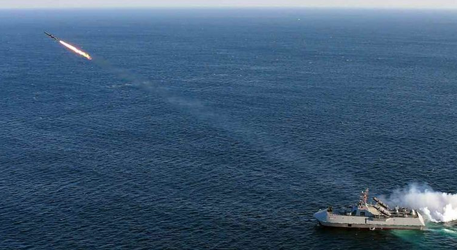
In February 2015, North Korean state media released images of their newest naval asset - a stealth ship.

DPRK Stealth Vessel

Media outlets around the world reported on the "official" recognition of the craft, however there's definitely more than one.

The vessel, which is similar to a hovercraft (something the North Koreans seem to be fixated on), features an angled hull and other features which help to scatter radar. You'll note the similarities in design between the small North Korean ship and the British HMS Daring destroyer seen here:

British HMS Daring

These "surface effect ships" use hovercraft technology to reach high speeds without the need to decrease the weight of needed weaponry.

North Korea has been trying to modernize its military for two decades, but change comes slow to an overly bureaucratic nation severely low on funds. 

The specific ship reported on has been known since 2009, when it was visible on satellite imagery of the Munchon Naval Base (11 miles north of Wonsan).

Ship onshore in Munchon, 2009.

However, after reviewing images from Wonsan (and comparing image dates), North Korea has at least two of these vessels. Both ships can be seen in their respective docks on images dated 10/3/2009.

Wonsan ship. 

The Wonsan ship can actually be seen on images dating as far back as 2002.


This class of vessel is armed with two 30mm automated close-in weapon systems (CIWS) which is based on the Soviet AK-630, four indigenously-designed 14.5mm rotary cannons, a new surface-to-air missile system, plus two mounts for two of the lethal anti-ship missiles. The key weapon system is the Kh-35 anti-ship missile system.

--Jacob Bogle, 2/12/2015
www.JacobBogle.com
Facebook.com/JacobBogle
Twitter.com/JacobBogle

Monday, November 3, 2014

New Road Construction in Kim Jong-un's Korea

Construction is currently underway for at least 170 miles of new paved highways (with more extensions planned). This is on top of the completed highway projects since 2005 which has made transportation between North Korea's major cities much more rapid.

Due to the lack of equipment and fuel, most of these roads have been built using manual labor (primarily by college students and soldiers) supplemented with decades old machinery.

(New roads outlined in bold white lines. There are undoubtedly more roads being constructed, the ones marked are just the ones I have found.)

Of the two longest new highways I've found, one runs north to south, connecting the port cities of Wonsan (pop. 335,000) and Hamhung (pop. 770,000). The second runs east to west and will help tie the core of the country to the expanded trade route with China via the New Yalu River Bridge (whenever it's completed).

The Wonsan highway will play a key role in Kim Jong-un's desire to turn the relatively quiet city into an international tourist destination. Wonsan already has a botanical garden, an 8,000 ft long runway, and several palatial vacation communities for North Korea's elite. It's also just a couple hours away (by car) from the famed Diamond Mountain (Mt. Kumgang) region.

(Highway construction progress.)

(Wonsan, park & docks. Click for larger view.)

(Wonsan, sea-side hotels. Click for larger view.)

(Wonsan Botanical Gardens. Click for larger view.)

(Wonsan, elite beach homes. Click for larger view.)

And finally, to the north-west, the New Yalu River Bridge.


Construction began in 2010 with China providing the bulk of financing (roughly $360 million USD) and materials. The causes of the delay in completing and opening the bridge have been North Korea's failure to meet its financial obligations, rising tensions between China and the DPRK, the re-directing of materials provided by China (for the bridge) to other projects around North Korea (projects wholly unrelated to the bridge), and the other usual mismanagement and glacial bureaucratic speed with which North Korea has become synonymous.

Whenever the bridge does open, it has the potential of greatly boosting trade and providing the country's economy with a much-needed infusion. Whether or not the bridge will be allowed to fulfill its expectations is another matter. 


--Jacob Bogle, 11/3/2014

Saturday, March 2, 2013

Update 2 + Sightseeing

I now have files started on all provinces, expanded my file on the DMZ and creating a new folder to deal solely with road blocks in and around the DMZ.

I've also re-organized each file to make them easier to use once they're published. Originally I simply had 3-4 categories for each area but that meant they were enormous and if someone only wanted to view train stations they would have had to un-click all the other placemarks. When I began, I had no idea just how many places would need to be marked. So now the main categories for all files are: Military, Monuments and Domestic but they each will have sub-categories, although there may be some differences dependent on the region.

Sub-categories will usually include:
Domestic - Irrigation & Dams, Road & Rail tunnels, Sub-stations, Fishing villages, Town signs, Burial mounds, Compounds, Road Blocks, Unidentified/Unknown items
Military - Coastal positions, AAA sites, Bunkers/Storage
Monuments will not have any sub-categories.

Also, I did a full count and to-date I have marked over 3,260 new places.

Now, let's have a bit of fun and do some sightseeing. As always, simply click on an image to enlarge it.

First there's this naturally made island in the northwest which looks remarkably similar to the real Korean Peninsula.


I wasn't the first person to find this island which would normally mean I wouldn't post it but I find it most intriguing and thought you would as well. Similarly, some of the other locations in this post have been known about for years but they're still interesting and we're "sightseeing" anyways.

Here's an example of the ~3,200 "Towers of Eternal Life" which were erected in every town and village after the death of Kim Il-sung.[1]


This is another monument. Well, actually there are two, the tower (right) and what is most probably a mural (center) of either Kim Il-sung or Kim Jong-il.


Here is one of the few working factories in the country.


Based on close-up imagery the factory looks like it was much larger in the past and as the North Korean economy flat-lined many of the buildings were torn down or fell into disrepair. There is still evidence of some production going on given the dark smudges on the undamaged roofs caused by pollution.

This image shows a large communications tower and shadow.


Korean's (both north and south) are traditionally a Confucian society. Part of that entails burial mounds instead of the below ground burials common to Western culture.[2] Here is an example of one such mound.


It is impossible to tell how old this mound is, but it is likely the person who died was either wealthy or an important figure in the region the mound is located in. During the famine, also known as the Arduous March, the bulk of the 1 million+ dead were buried in mass graves or in smaller, irregularly shaped burial mounds. These can be seen on almost every hill in the country. I suppose this mound could have been built for an important person who died during the famine, but again, it's impossible to tell.


This is Sariwon, the capital of North Hwanghae Province. From space, at least, the city looks nicely maintained, has a well laid out street plan and would be a nice place to live. It has a population of over 300,000. The park located slightly off center-left contains a very large statue of Kim Il-sung.

Finally, we have a vast vacation compound in the port city of Wonsan.


I have zoomed in on Kim Jong-il's villa.[3] The grounds contain a number of large homes (you can see two of them on the right side) which are for government officials and guests. The two largest homes both belonged to Kim Jong-il. When he died Kim Jong-un demolished a number of his father's homes but so far this one has remained intact and will likely be used for years to come.


Sources:
1. North Korea's Cult of Personality, Wikipedia
2. Traditional Korean burial mounds, NK Economy Watch
3. Kim Jong-il staying at villa, Daily NK


--Jacob Bogle, 3/2/2013
www.JacobBogle.com
Facebook.com/JacobBogle
Twitter.com/JacobBogle