Showing posts with label heliport. Show all posts

Wednesday, May 24, 2017

Kim Jong-un's Secret Escape Plan

Pyongyang has one of the deepest subway systems in the world. It dives as much as 360 feet (110 meters) beneath the earth. And like many subways in national capitals, there are rumors of secret train lines that stand ready to spirit the country's elite to safety in the event of war or revolt. North Korea applied much of what it learned from the Soviet Union when it comes to protecting the leadership: from secret subway lines, to tunnels that run for miles connecting various palaces and government buildings, and even an alleged one that extends all the way to China!

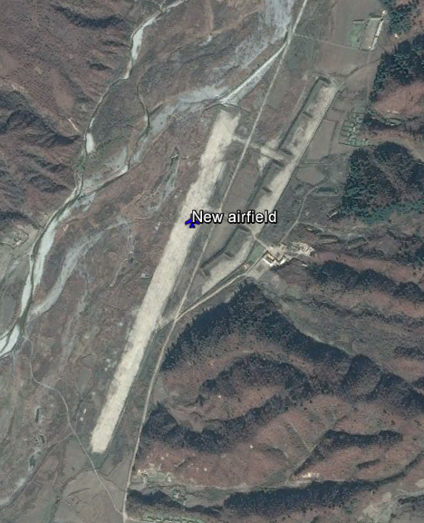
There are special runways, helipads, and train stations that allow the Kims to travel the country in luxury and safety (and without having to wait in line for hours like the average peasant). These "No. 1" train stations are well known and easily identifiable, and even the special runways can be found with little effort (including the new ones that keep popping up), but it can be difficult to find tunnels via satellite. It's even more difficult to verify the rumors about secret underground escape routes.

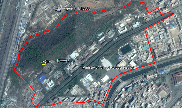
There is an arc of natural hills that lie north of downtown Pyongyang, and each of them is covered with military bases, intelligence buildings, artillery sites, etc., but one of them is special. Located next to the Ministry of Armed Forces District, a hardened, partially underground heliport reveals itself. Its exact coordinates are 39.0633°, 125.7336°, and since I haven't seen any (ANY) information about it, I thought it would be a good idea to share what I know.


It's within a mile of four known metro stations, adjacent to the West Pyongyang Train Station, and near a main arterial highway. You can use all three modes of transportation to rapidly go from Pyongyang's secured government quarter to the Military District. And if there are secret tunnel connections, Kim Jong-un could make the trip without fear of being blown up. It's also only 4 miles (6.4 km) away from the newly modernized elite heliport which is used by Kim and the regime's top dogs, and 10 miles (16 km) south of Pyongyang Int'l Airport (which doubles as the home of North Korea's version of Air Force One).

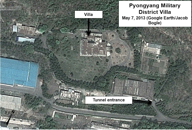
This secret "get out" heliport is not directly connected to the Military District above ground. In fact, a multilayered fence divides the two areas, however, a tunnel exits near a villa that goes into the hill and could theoretically connect the two areas, which are less than 500 meters apart.

Google Earth/DigitalGlobe image clearly showing the tunnel entrance and villa. Dated May 7, 2013.

Based on satellite imagery, the heliport and associated buildings was under construction in June 2000 and was completed by November 2000.

Here is a Google Earth image from June 12, 2000 showing the construction process.


This one shows the completed work on Nov. 5, 2000.


The area surrounding the heliport also underwent drastic changes over a number of years. Below is an image of the area on Nov. 5, 2000.


After several years of work, the area had been completely changed. Most of the work was completed by the end of 2006.


More recent activity was seen in 2013, when one of the hardened hangars was demolished following what appears to have been a collapse. The apparent collapse occurred at the start of 2013 and the cleanup work seems to have been completed by the end of the year.


While helicopters haven't been seen in any public access satellite images, the protective hangar doors have been seen opened in several images. One such time was May 10, 2016.


In September 2016, what looks to be the scorch marks from a fire or explosion can be seen on the left landing pad. On the Google Earth image dated Aug. 27, 2016, an unidentified object or mound of material can be seen on the landing pad. By the Sept. 23 image, a large blackened area can be seen, indicative of a fire or explosion.


While I don't know if the object/mound in the first image is actually related to the explosion, the fact it was there soon before is worth mentioning. The burnt area hasn't been repaired as of April 22, 2017.

Trying to figure out where Kim Jong-un could go without knowing what kind of helicopters are available here is a bit of a guessing game, but if we assume they're one of the known helicopter types North Korea has (such as the Mi-8 Hip, or Mi-2 Hoplite), he could easily reach 270-300 miles (434-482 km) before needing to refuel. That range places nearly every other airport, palace, and key military base in North Korea within reach. It would also enable an emergency flight to China.

What exactly goes on at this site or where Kim Jong-un could ultimately end up if he had to flee can only be a matter of speculation (for now), but it's obvious the regime has taken great steps over the years toward protecting itself.


--Jacob Bogle, May 24, 2017
JacobBogle.com
Facebook.com/JacobBogle
Twitter.com/JacobBogle

Additional Reading
1. Report: US has mapped North Korean underground escape facilities (Aug. 5, 2015, Stars and Stripes)
Sunday, November 15, 2015

North Korea's Air Force & Airports

NOTE: Scroll to the bottom to download a Google Earth KMZ file of all airfields and heliports.


Introduction

The Korean People's Army Air Force was created in 1947 and is one of five branches of the Korean People's Army. Today it has around 1,000 aircraft with 110,000 personnel. Given the military primacy system (Songun) of North Korea, we might as well consider domestic and military aviation controls as one and the same.

The KPAAF is currently divided into six divisions: 1st Air Combat Command (HQ at Kaechon), 2nd Air Combat Command (HQ at Toksan), 3rd Air Combat Command (HQ at Hwangju), 5th Air Transport Division (HQ at Taechon), 6th Air Transport Division (HQ at Sondok), and the 8th Air Training Division (HQ at Orang). These are all controlled by the central Air Defense and Combat Command which is headquartered in Chunghwa, Pyongyang.

(As always, click on the pictures to see a larger view.) 


Combat air divisions consist of four to nine air regiments, service and support units, and have approximately 160-300 aircraft.
They are organized into a headquarters and division command post, three to six fighter regiments, one bomber regiment, one to two helicopter regiments, five to seven anti-aircraft rocket brigades (SAM brigades), communications center, radar regiment, nuclear-chemical defense battalion, engineering battalion, transportation battalion, guard battalion, and a maintenance and repair unit.

The overall combat readiness of the air force is low, ranging from 50% to 70%. Due to ongoing fuel shortages and lack of repair equipment/parts, training flight time is usually less than an hour and generally consists of take-off's and landings.

Airfields

The country has a total of 99 airfields and heliports. There are 12 main airfields, these include the six divisional headquarters, Pyongyang International Airport, Wonsan Airport, and others. There are 14 highway strips which are widened lengths of road used to serve as emergency runways in the event of war or other crisis. Of all the airfields, 20 are basic grass landing strips, 33 are paved, and 19 are heliports or single helipads. Ten of the known airstrips that still exist are also either fully abandoned or severely neglected. One thing I find curious, is that Chagang Province only has one airport, at Manpo. Chagang is a key military manufacturing region with otherwise limited infrastructure (it only has two domestic access points by rail).

This shows the locations of all the airfields. The plane icons are for planes, helicopters for heliports, and the divisional headquarters are shown larger.


Improvements

Over the last few years there have been a number of improvements/expansions made to existing airports, and a few new ones have been constructed as well.

Located about 12 miles from the heart of Pyongyang, North Korea's only official international airport (Pyongyang-Sunan International) underwent renovations and the expansion of its terminal.

The following pictures are of the terminal before and after primary construction was over.


Another facility in Pyongyang to undergo improvements was the VIP heliport in downtown. Situated along the bank of the Taedong River and among elite neighborhoods, the original heliport was completely demolished and new one was built next to the old site.

Former heliport
New site

Moving across the country to the east coast city Wonsan, we find North Korea's newest (as of yet unofficial) international airport - Wonsan Airport. With Kim Jong-un's approval, starting in 2013 the airport underwent an extensive remodeling with the intent of enabling the development of a planned "Wonsan-Mount Kumgang Tourist Zone". The airport project is estimated to have cost $200 million. If true, that would represent over 1% of the country's entire economic output. For some perspective, 1% of America's GDP would be $170 billion.

Each year North Korea receives around 100,000 visitors, Wonsan's new capacity is 1.2 million. The original plan for Pyongyang's expansion was to accommodate 12 million!

Here's a side-by-side comparison of the before and after.


There have been two new airports built in the last few years. There's a new Kumgang Airport (which is still not operational) that I wrote about in March 2015, and also in 2015, North Korea built a small paved airfield next to the International Friendship Exhibition.

Here is the unused Kumgang Airport which replaced the grass Kumgang landing strip.


Google Earth File

I have been able to pull from different sources (not to mention the fact I've literally looked at every square mile of North Korea) and was able to put together a Google Earth KMZ file. It contains the locations of all 93 existing current and former airfields/heliports, along with a visual count of all aircraft seen, and additional information/links for certain airfields. To explore the file you will need have Google Earth.

To automatically download the file from my Google site "AccessNorthKorea", just click THIS link.
To check out the site first (not much there yet) you can visit it here. The file name is "AirportsAirbases-updated-12-1-15.kmz".

Further Reading

Korean People's Air Force, Wikipedia article
North Korea Air Bases, Federation of American Scientists
Korean People's Air Force, Wikileaks document


--Jacob Bogle, 11/15/2015
www.JacobBogle.com
Facebook.com.JacobBogle
Twitter.com/JacobBogle