Showing posts with label August. Show all posts

Wednesday, August 30, 2017

North Korea's Sacrificial Islands

When North Korea isn't firing intermediate and long-range intercontinental ballistic missiles (ICBMs) from highways and hidden factories, they're firing hellish amounts of smaller artillery. For the past several years, some of the recipients of these displays of military might have been two small islands off the coast of Wonsan.

The islands of So (So-do) and Hwangto (Hwangto-do) have been pummeled multiple times. Most recently in April and August 2017, December 2016, and March 2016. This video, originally from the Korean Central News Agency, discusses the August drills and shows images of the islands.

English-dubbed Video Source: StimmeKoreas

Both islands lie off the Kalma Peninsula, which is where the Kalma Airport is located (North Korea's recently modernized airport). Kalma is also the site of two rocket launch pads and has seen at least one failed rocket test.

So Island is approx. 6.7 km east of the tip of Kalma (among a small group of islands) and, farther south, Hwangto Island is 2.45 km east of the beach. At the tip of the peninsula are several villas, a sanitarium, and a possible hotel.

(Click on images for larger view)


Without further ado, here are the island martyrs.

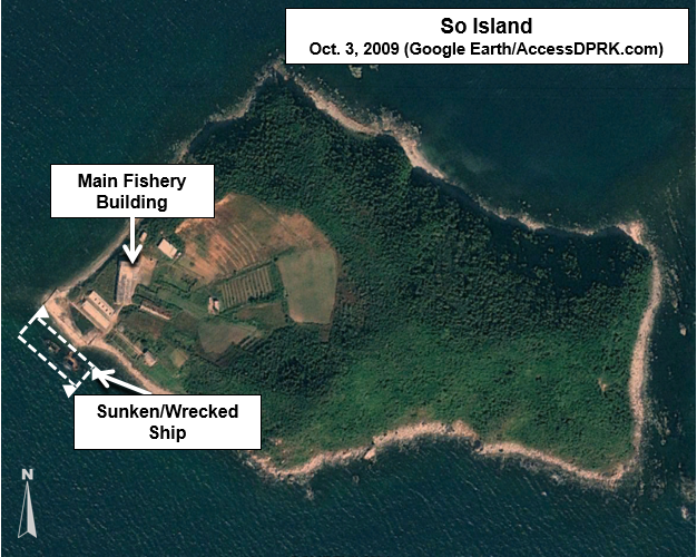
So Island has a more recent history. Prior to 2014, the island appears to have served as a small outpost, perhaps for local fisherman. It contained a few buildings on the western side, and the rest was left alone. The buildings were demolished in late 2014.


So Island is a mere 460 meters by 293 meters at its widest points. As noted earlier, So Island was the target of an artillery drill in December 2016. The image below shows the results of that barrage.


This is a picture from the Korean Central News Agency showing the island being hit during the 2017 drill. The large island seen the background is Sin-do.

Image Source: TheSun.co.uk

Next is Hwangto Island, which has a longer history of being a bombardment target.


Hwangto is slightly larger than So at 587 meters by 295 meters. In the image below, shelling damage can be seen from a drill that occurred not too long before May 17, 2011. There is also a small building that has been demolished. 


On both islands, the structures seem to have been manually demolished rather than destroyed as a result of artillery. 


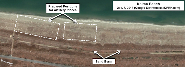
The above image shows the various prepared firing positions along the beach at Kalma. These sites are angled to line up with the the target on Hwangto Island.

In this KCTV picture from April 2017, the firepower displayed is rather impressive. An estimated 400 pieces of artillery were used.


The below image is the most recent on Google Earth. Dated Dec. 8, 2016, you can see the damage done from additional artillery drills as well as a new target. That target was used during the April 2017 drill.


Thanks to the support of OpenDPRK, I can now show you the results of this recent onslaught. 


The largest craters are 10-13 meters in diameter. 

These displays of might happen a few times each year and usually coincide with major holidays or as a response to US-ROK drills. 

I wonder how many more artillery drills it will take before the cliffs at So Island collapse?


--Jacob Bogle, 8/30/2017
JacobBogle.com
Facebook.com/JacobBogle
Twitter.com/JacobBogle

Friday, December 2, 2016

Over Half Million Affected by Floods

Flooding during monsoon season is an annual problem for North Korea, especially given its mountainous terrain and poor land management practices. Heavy flooding in August is said to have affected some 600,000 people according to North Korea's Red Cross Society. Urgent aid was needed as winter comes early and harsh, particularly for those in northern areas (which also tend to receive less government attention and assistance in general).

Map of Tumen River.

The primary river in the northeast of the country is the Tumen, which flows from Mt. Paektu and forms part the DPRK-China border and near it's mouth, the DPRK-Russia border. The river drains some 5,000 square miles (13,000 sq. km) of rugged and mountainous areas of North Korea.

According to the Korean Central News Agency, reconstruction has now finished in Hoeryong, North Hamgyong Province, including a new kilometer-long dike to protect against further flooding of the Tumen.

Here are some satellite images of the flood damage along the river, including the cities of Hoeryong and Musan. The occassional curvy and thin yellow line is the map border between North Korea and China. Simply click on any picture and you'll be able to see larger versions.

This is a before and after image showing flooding behind the old Tumen River Dike. It shows a new river channel and destroyed buildings.


Here is a picture of one of several portions of road that was washed out along a tributary to the Tumen in the Hoeryong region.

The next two pictures give a before and after view of a Hoeryong neighborhood that was completely destroyed by the floods.


Nearby is the only non-rail bridge that connects that neighborhood to the rest of the city. The flood took out a section of it.

Moving up river, toward Musan, there's a section that shows distinct flood damage. You can see debris and mud built up in the river bed, discoloration of the land where crops were destroyed, and a road that was "smeared" out as the Tumen overflowed its banks.

Here is a small village that was almost completely erased.
Before the flood:

After:

In Musan, the destruction wasn't limited to just a flooded river. Musan is a key mining city and sits in a series of vallies with steep hills and mountains surrounding it, there's a tributary river running through it and then, lastly, the Tumen cuts off the western side.

Here you can see buildings destroyed by the Tumen.

And here are homes that were buried in mud and rocks as otherwise dry ephemeral mountain streams turned into raging torrents.


Finally, the Hoeryong border crossing facility was also severely damaged. At least two of the buildings suffered major damage and the land around the facility was wrecked. In the satellite image you can also see some of the construction equipment as the government tries to clear the area and make repairs.


--JacobBogle, 12/2/2016
www.JacobBogle.com
Facebook.com/JacobBogle
Twitter.com/JacobBogle - Use the hashtag #AccessDPRK to join the conversation!