Other Pages

Sunday, March 28, 2021

What's Inside North Korea?


This is a breakdown of North Korea by the numbers based on the AccessDPRK 2021 Map, Pro Version. This is similar to the North Korea by the Numbers post I made for the 2017 map.

Since I want to give a full accounting of all of the different places that are in the country, I am basing this off of the Pro map, which has thousands more places than the free version


My interest in North Korea began in late 2012, then I found some older maps others had done and decided to make a truly comprehensive version, as all of the others were either severely lacking or only focused on one sector (like Planman's great work on air defense sites). I started the blog in 2013 and released an early version of the work in 2016. Then came the first "full" map in 2017 and finally the 2021 map, which will be the last comprehensive nationwide map of the country I plan to make. 

As all of my maps have been divided into monuments, military, and domestic sites, I'll give their overall numbers first.

The project has located 11,661 extant monuments in North Korea. There's 13,566 military sites (manned, unmanned, and former). And there's 39,407 domestic sites marked. This represents a 18.1% increase from the 2017 map; however, the military folder is actually over 41% larger than the 2017 military folder. That's 64,634 sites.


The provincial breakdown for the monuments is:


In 2019 I published an initial survey of the country's monuments. The total figures have grown slightly since then, but the article also talks about other monument-related things and is worth checking out.

Compared to 2017, thanks to improved imagery and new construction, there are 1,765 more monuments located. The Pro version also includes the dates many were constructed, and from that we can now know that at least 623 monuments, murals, and bronze statues have been installed under Kim Jong Un. 

There are also three sites in Pyongyang that are prepared for future statues, but the statues have not been erected yet. 


The military folder of the 2021 Pro Map is over 41% larger than the 2017 military folder. This isn't because I missed a bunch of places, but it's due to the fact that I wanted to give an even more granular look at the country's military, trends, and changes over time. This means I focused on mapping even former facilities, located the storage sites within military bases, paid special attention to locating tunnels and underground sites that may have been well hidden, and marked important bases (like missile sites) with greater detail. The change is also due to improvements in available imagery, making it possible to discover things that were previously too blurry to be identifiable. 

A few of the specific improved numbers are: 110 additional observation posts along the DMZ (at least 18 were built after 2015), 44 additional radar facilities, 67 more AAA sites (15 were built from 2015-2019), and over 400 additional verified military bases. Then there's the 126 hardened artillery sites that have been constructed since 2010. However, one of the largest increases comes from the storage facilities (stand-alone and within other bases) that I gave more attention to for 2021. The map includes 1,337 of them. That's a further 650 sites compared to 2017.

Since I have also tried to locate former artillery sites (so that other maps can be updated) and additional decommissioned bases to help researchers understand military infrastructure trends, I think it's important to say that of the 13,566 military-related sites, only about 900 (or 6.6%) are not part of the country's active defense. That means there's roughly 12,666 currently used sites (everything from missile bases to static, anti-invasion road blocks to tunnel groups and DMZ posts).


A notable change between 2017 and 2021 is the fact that there are 314 fewer propaganda signs marked. This is because many of them are simple wooden signs or chalk outlines on hillsides. Over time they fall down or are washed away. 

The demolition or other removal of sites, plus the fact that I did not include two 2017 categories (mountain peaks and Pyongyang bridges), means that the gross difference between the two maps is actually closer to 21-22%, and that the 2021 Pro map has ~11,600 entirely new places vs. 2017.

Some other changes worth noting is that there are 320 additional dams and hydroelectric sites marked, 71 additional markets, 371 more border posts (reflecting Kim Jong Un's efforts over the years to end defections), and there's the places that can only be found in the Pro Version. These include 149 gas stations (a growing trend in the country), the locations of 320 likely Railway Security Bureau facilities, and a national map of the country's lighthouses (some of which were only built in recent years).


Notes:

I want to add a few notes to help with context and prevent any confusion.

While most of the categories are indeed individual sites (there are 1,485 distinct electrical substations for example), some of the categories include not just the primary location but also sites within those places. A great example of this is that there are not 412 prisons in the country. There's 53 known, suspected, and former prisons that I was able to locate. And many of those prisons include detailed maps that also mark where the guard huts are, where prisoner housing is, and so on. So, one prison may be represented by 20+ items, and that's how I get to 412 total sites within the prison category.

The categories that have these more detailed folders are: prisons, missile bases, some historic sites, several of the "elite compounds", and a few factories. Additionally, some of the "province only sites" include multiple sites per place. This is especially true in Pyongyang which has the most of these province-only sites. An example is the Ryongsong Residence, which located within the "province only" folder, but that one residence includes 47 detailed sites within its folder. So, while there are 681 markers within the whole "province only" category, they're only representing around 275 primary places as several of those primary places have numerous sites marked within.

Lastly, in some cases I did not try to map every single one of the sites within a category. There are notes in the respective folders saying this, but they are: irrigation pumping stations, water supply, factories, agricultural sites, internal security checkpoints, parks, and gates. I tried to map a majority of sites and all of the important ones with the exception of the water supply sites, agricultural sites, internal checkpoints, and gates. For those, I wanted to give a representative sample and to locate major places. I only marked gates in cases where a facility was large and the main entrance could be difficult to find, and in cases where the gate itself was interesting/large.


I would like to thank my current Patreon supporters: Amanda O., GreatPoppo, Joel Parish, John Pike, Kbechs87, Planefag, and Russ Johnson.

--Jacob Bogle, 3/27/2021
Sunday, March 7, 2021

Is Wonsan Prison No. 88 Closing?

Located near the city of Wonsan, in the village of Sokhyol-ri, is a small reeducation prison camp (39.158666° 127.363326°). 

Reeducation camps (Kyo-hwa-so) are different from the major concentration camps (Kwa-li-so) most are aware of. These are smaller prisons that use forced labor to "correct" the thoughts of the prisoners and instill in them greater love and respect for the state. Through their labor they are remade into "good citizens". However, these prisons aren't like the ones found in America or elsewhere where prisoners make car license plates for nominal pay or a chance at an early release.

Prisoners can be required to work 18 hours a day doing hard labor and being beaten by their guards. All while being fed only a subsistence diet. There's no check waiting at the end of their sentence and they often experience lifelong disabilities. This is undoubtedly true at Sokhyol-ri (Kyo-hwa-so No. 88) because the prison provides the workforce for a nearby quarry. 

The public became aware of Kyo-hwa-so No. 88 in 2011 through the Database Center for North Korea Human Rights (NKDB) publication Prisoners in North Korea. While the camp has since been mentioned by other organizations, there remains very little public information about the prison. However, a review of Landsat imagery shows that it has been in operation since at least 1985. And, unlike many smaller prisons that were closed down throughout the 1980s and 1990sKyo-hwa-so No. 88 was kept operational. 

There are no prisoner testimonies directly from Kyo-hwa-so No. 88, but the quarrying site was identified as the prison by the Committee for Human Rights in North Korea (HRNK) in the 2017 Parallel Gulag report, as its layout fits with known prison designs in the country.

In 2012 the active quarry site was about 6,500 sq. meters in size. By 2020 it had grown substantially. The largest quarry expansion corresponds with the changes to the prison complex from 2017 and 2019. Based on its maximum size, I estimate that the prison population is between 1,000-1,500.

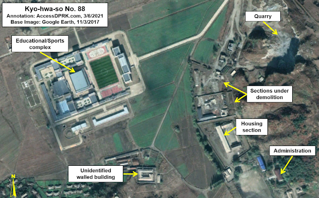
There is a small walled building 180 meters to the east of the main prison that was constructed in 2007. The compound encloses 2,020 sq. meters. I do not know if this is a prison annex or has another purpose.


Layout of Kyo-hwa-so No. 88 in 2009 before any demolition or closure.

From the above Google Earth image, one can see the layout of the prison as it was at its height. A perimeter wall surrounded part of the quarry and the workshops and housing are fully encircled by walls. The eastern part of the prison complex (the area behind the quarry) does not need any substantial security as the quarry itself provides a wall of stone, enabling that portion of the prison to be protected by a handful of guards. The explosives area has its own fence and a security hut (added in 2012), ensuring that materials aren't stolen.

In 2009, the prison and quarry complex occupied approximately 17.1 hectares.

The first major sign of change came in 2013, when the roof of the main workshop had been removed.

Image of Kyo-hwa-so No. 88 from April 20, 2013, showing the roof removal.

These kinds of changes aren't uncommon to see. Sometimes buildings are replaced or expanded. But as we will see, this was just the first large change to be seen at the prison as part of the facility appears to be undergoing a slow dismantlement. 

The next change comes in early 2016.

Kyo-hwa-so No. 88 as seen on Feb. 26, 2016.

By early 2016 the perimeter wall around the quarry had been removed; its debris still visible in this image. Additionally, the main workshop and another building had been fully demolished.

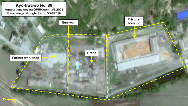
Three months later, the workshop section of the prison had been divided by a new wall and a new building was under construction.


A year later, in 2017, the newly created section was filled with new and remodeled buildings. 

The new center section has been filled with new buildings and the left-side section is no longer closed to the quarry.

The evolution of the workshop half of the original prison seems to suggest that it was divided into two segments to allow the far-left side to be open to the quarry as facilities for civilian use. I come to this conclusion by the lack of a quarry perimeter wall and the fact that the new center section is cut off from the left side by a new wall. The center section could still be part of the prison and used for forced-labor projects, but perhaps the quarry had been turned over to civilian control. 

Internal security agencies handing over mining and quarrying facilities to civilian authorities is not without precedent. It happened when Kwan-li-so No. 17 in Cholsan (a prison at an iron mine) was transferred out of police control ca. 1984-85. The now civilian iron mine is still operational.

However, this possible experimentation in having older prisons facilities used for civilian purposes while still having an active prison on the other side of the wall doesn't seem to have lasted long.

By November 2017, the structures in the new section were being demolished, part of the original prison wall now shows a gap, and another segment of wall had been removed.

The changes seen in late 2017 coincide with the completion of a large educational/sports related facility less than 250 meters away. This could mark the final transition of the prison being a forced-labor camp, to a more conventional detention center. Having large numbers of children and young adults driving by with a labor camp in clear view may have painted the wrong image for the regime. Of course, this is just speculation on my part.


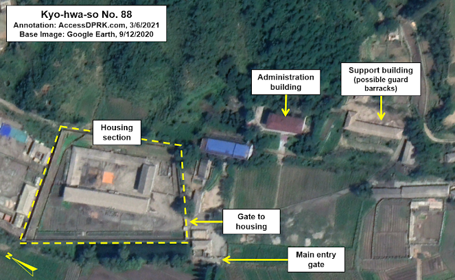
Regardless of my speculation on the regime's reasons for the changes, subsequent observations make it very clear that half of the prison is being demolished and repurposed, and that the quarry is no longer part of a secured, prison complex.

Currently, the prisoner housing and administration area occupies ~6.48 hectares, while the quarry size has grown by 28% since 2007. 

Whether or not the prison has been fully decommissioned or merely decreased in size, with the quarry becoming a civilian site, is not confirmed. The urge to speculate is strong, but the only things that can be said for certain are what the satellite images show us. Not intentions, not the future. 

However, as I've said above, such changes have happened before. It could also be the case that the regime is in the process of realigning their prison system. Unfortunately, reports of recent amnesties followed by reports that Kim Jong Un is going to be expanding the prison system doesn't give us a clear answer. 

It is just as likely that Kyo-hwa-so No. 88 is changing its place in the system, from a forced labor camp to a local detention center according to the current needs of the state.

In any event, while the system remains dynamic, it is decades old and likely in need of substantial reform. Newer facilities, realignment of the major camps, and a more modern incarceration process would actually be beneficial from regime's standpoint in numerous ways. 

Regardless, even a partial closure of a prison usually means a partial release of prisoners (as others are transferred elsewhere). For those that may see their sentences ended, this change is only good news.


I would like to thank my current Patreon supporters: Amanda O., Anders O., GreatPoppo, Joel Parish, John Pike, Kbechs87, Planefag, and Russ Johnson.

--Jacob Bogle, 3/6/2021