Saturday, February 20, 2016

The Lost History of Korea

(UPDATED Feb. 9, 2017)

This blog is three years old today! (OK, four years on Feb. 20, 2017)

When I started this mapping project four years ago, I had no idea how intensive of an effort it would become, nor did I realize there was so much ancient Korean history north of the DMZ just waiting to be mapped. So to celebrate this anniversary, I'd like to share with you some of the ancient sites and fortresses I have found in North Korea. I was able to map 213 locations (including additional wall segments of otherwise known sites). Of these sites, I can't find any information on at least 2/3rds of them. I have found several tombs as well, but those aren't part of this data release because they're part of the larger "burial mounds" section of the main mapping file and will be released in due time. Those 213 sites are in addition to the 113 sites found by Curtis Melvin's "North Korea Uncovered" project. Many of them, likewise, aren't identified other than their location.

Using satellites to search for archaeological sites was pioneered by Dr. Sarah Parcak, particularly in Egypt. And while the purpose of #AccessDPRK wasn't just to find ancient sites, having literally looked at every square mile of North Korea, I have been able to help fill in a lot of holes in this part of the world and I look forward to the experts providing the details one day.

You can download the full Google Earth file with all 336 historic North Korean sites at the bottom of this article. It also includes 56 ancient forts and city walls in South Korea!
(This map shows you the general locations of all 336 archaeological sites.

When most people think of Korean history, they focus on the Korean War, or perhaps, look as far back as the occupation by Japan which began in 1910. However, just like their neighbors China and Japan, Korea's known history dates back thousands of years. Unfortunately, that relatively modern event of Korea's division and war did mean that whatever history that had touched the northern half of Korea was, in many meaningful ways, lost to the West.

Undoubtedly there are scholars both north and south that know about most of these places, if not all of them, but for those of us without advanced degrees in Korean archaeology, many of the places I have found are enigmas.

First, I would like to give you a quick primer on pre-1900 Korean history starting with the Three Kingdoms Period. The Three Kingdoms Period, which began in 57 BC, was when the Korean Peninsula, and part of what is now China and Russia, was dominated by three kingdoms, the largest of which was Goguryeo (and it encompassed all of modern North Korea). The other two were Silla and Baekje, along with a few small tributary states.


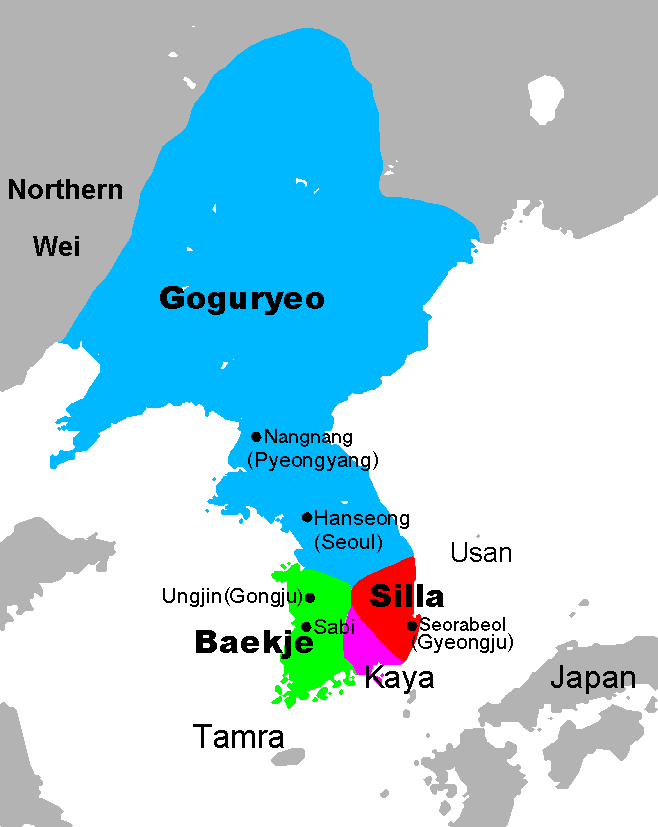
The period ended when Silla, aligned with China, conquered Goguryeo in 668 AD. During those turbulent years, a "great wall" of Goguryeo was constructed that extended from Bohai Bay, moving northeast 300 miles to modern-day Nog'an County in China. It is important to note that for centuries, the history of Korea was strongly influenced by the machinations of China, and at times, the nominally independent Korean kingdoms were still client states of China. What followed the end of the Three Kingdoms Period was a two-state system, Balhae in the north and Silla in the south. 

Both states existed until the unification of Korea under the Goryeo dynasty in 936 AD. In the 11th century, the Goryeo built a second "great wall" (both of which are called Cheolli Jangseong or Thousand Li Wall). Like its northern predecessor, it too stretched for 300 miles, except its course was more or less west to east and was entirely within the territory of today's North Korea. 

Red: Goguryeo wall Blue: Goryeo wall

The Kingdom of Goryeo thrived until the Mongol invasions in the 13th century. Finally, between 1388 and 1392, a civil war led to the death of the Goryeo ruling families and its throne was usurped by General Yi Seong-gye forming the Kingdom of Joseon which lasted until 1910. I would like to point out that Korea was a unified peninsula for 1,009 years (which ended in 1945 with the division of Korea). The artificial and forced division that affects North and South Korea still stings and both sides want eventual reunification; they're the same people with the same language, the same shared history, and in many respects, still retain the same culture

During all of this history, various defensive walls, forts, and fortified settlements were constructed all over Korea. There were likely fortified settlements built prior to the Three Kingdoms Period as well, but I can't find any information about them. Here's the official list of the "National Treasures of North Korea".

While these places are in North Korea, I have to stress that these sites are part of the history of all Koreans, and indeed, the world. Korea's distant civilizations and their advances mirror the great leaps in China, the Middle East, and Europe and should be preserved. Perhaps in the future, as we hope for bettering relations between the DPRK and the rest of the world, and even hope for unification, these sites will become known and fully researched so that another chapter of human history can finally be completed.

North Pyongan Province has the most sites with 98. I have marked 71 and Melvin marked 27.

(The various blue lines map out the different defensive walls.) 

Excluding fortress walls, I've mapped out around 50 miles of long defensive walls. These walls are roughly broken up into 3 main lines. Two walls run parallel to each other in the north and a third is located farther south near the border with S. Pyongan Province.

These walls follow the contours and peaks of mountain ranges.


There are several fortresses and walled cities in N. Pyongan. The most impressive is the ancient city of Yongbyon. That name may sound familiar to you because the Yongbyon Nuclear Facility is located nearby. National Treasure number's 46-50 are located here.

(Yongbyon Walled City. Blue lines/markers are mine, yellow are Melvin's.)

The single densest archaeological region is near the city of Sinuiju.


With tensions currently very high between North and South Korea, and South Korea having recently closed the Kaesong Industrial Region (which is a joint-venture physically located in North Korea), I'd like to move south to the city of Kaesong. Kaesong has a very long history and served as the capital of Goryeo between 919-1394.


Many historic sites in North Korea are at risk of being destroyed, particularly those in urban areas. Portions of Kaesong's old wall (Nat'l Treasure Nos. 129/130) have been destroyed due to mining.


Similarly, the Kyongsong walled city (National Treasure No. 118), is at risk. Three roads have cut through the wall and a sizable portion of the southern wall has completely disappeared as houses have been built there.


Near the city of Munchon, Kangwon Province, there is a hillfort and a long wall running west.


There are 24 sites in North Hamgyong Province and I was a bit surprised by how many there are. The northernmost portions of Korea have long been given the lowest priority, both during the imperial era and during the DPRK regime. Although, I suppose if you do treat a region poorly, you might want to build some forts to keep the peace.

The northern part of the valley where the town of Komusan sits, splits into two smaller valleys. Each one holds a fortress (less than 3 miles apart). One of the forts has had its northern wall demolished for a rail line to go through and the other fort has a lot of damage from centuries of erosion.


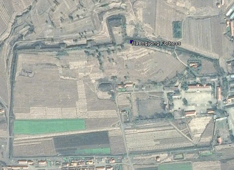
One of the most interesting sites is actually located in the Hoeryong Concentration Camp (Camp 22). The small adjacent village is called Haengyong and so I have dubbed it Haengyong Fortress. The site is where the camp administration buildings are located.


Moving on to cultural sites, located throughout the country are small temples and shrines. These are the remnants of a former deeply religious civilization. During the establishment and consolidation of North Korea's atheistic regime (unless you count their personality cult), Kim Il Sung had many places of worship destroyed. Fewer than 300 remain and the majority of those have been abandoned; some are still "active" as cultural relics.

Here are two typical sites. Both are in North Hwanghae Province and are nestled in the mountains away from populated areas (which might explain why they haven't been demolished).


The last place I want to show you is Kyongsong Hyanggyo. Located half a mile from the city walls of Kyongsong, the site is an old civil school. These were part of a system similar to the Chinese imperial examination system. These schools were where members of the Yangban (elite class) would go to become civil servants and bureaucrats. Various schools were created between 918 and 1392, and 1392 to 1897.

According to older imagery, the main building was damaged and then reconstructed around 2009/2010.

All 392 sites mapped in Korea. 336 for the North and 56 for the South.


To access all 392 ancient sites in Korea, you can either visit my file archive here and click the download button for "Koreas Ancient History_Final_2-9-17.kmz" or download it directly by clicking this link. To view the places you must have Google Earth.

The KMZ files are hosted on my Google Site https://sites.google.com/site/mymappingprojects/access-north-korea


--Jacob Bogle, 2/20/16 (updated 2/9/17)
www.JacobBogle.com
Facebook.com/JacobBogle
Twitter.com/JacobBogle
You can use the hashtag #AccessDPRK when discussing on social media.

Sunday, January 17, 2016

Manpo-Changchuan Hydroelectric Dam Construction Continues

Some 8 miles (13 km) north of Manpo, North Korea, along the Yalu River border with China, a new hydroelectric dam has slowly been growing. It's named for the village of Changchuan, although the North Korean name given is Mun'ak.

Satellite imagery suggests that construction on the dam began sometime around 2013 and has been proceeding from the North Korean side to China; the nearest Chinese city being Ji'an.

You can see the beginning stages of construction in this image from January 5, 2014.


I haven't been able to find much additional information about it. NKEconomyWatch posted that North Korea and China were planning to build two additional hydroelectric dams on the Yalu. One would be built from the Chinese side and the other would come from North Korea.

The North Korean dam, located by the small village of Changchuan, is estimated to cost $78 million and is expected to produce 154 million kWh annually (enough to power 14,000-20,000 homes). The initial agreements to build the dams came in 2004 and 2008, with a proposed completion date of 2013. Obviously, they've fallen behind.

This image from October 21, 2014 shows the work advancing and shows the hydroelectric generating station under construction.


The original width of the Yalu River at this point was around 850 feet (259 m). The latest imagery available, May 24, 2015, shows the dam has pinched the river into a 100 foot (30 m) wide neck. It also shows a cofferdam large enough to facilitate the construction of 4-5 additional "ribs", and that the hydroelectric station's construction is also continuing at pace. The hydroelectric facility has rooms to hold 4 generators.


Here is a picture of the "worker's village". It includes housing, manufacturing buildings, and equipment sheds.

A mile (0.6 km) north of the construction site, they have carved out a quarry on the river bank to use for the cofferdam and, possibly, the concrete used in building the dam. The quarry covers approx. 330,000 sq feet (30,600 sq meters).

It also looks like the dam was originally going to be built 0.8 miles to the north but was moved to its current location for some reason.


The nearest completed dam is the Yunfeng Dam, which is 12 miles (40 km) north and became fully operational in 1967. It has a 400 MW generating capacity. Once this dam is completed it will be the fifth hydroelectric dam on the Yalu.

UPDATE - Aug. 31, 2018
After missing the initial completion deadline, the dam is slated to be completed in 2019. The construction of this and other Yalu River dams is expected to bring in millions of dollars' worth of energy trade with China, something not banned by UN sanctions.

Construction progress as of May 5, 2018.


--Jacob Bogle, 1/17/2016
www.JacobBogle.com
Facebook.com/JacobBogle
Twitter.com/JacobBogle

Sunday, November 15, 2015

North Korea's Air Force & Airports

NOTE: Scroll to the bottom to download a Google Earth KMZ file of all airfields and heliports.


Introduction

The Korean People's Army Air Force was created in 1947 and is one of five branches of the Korean People's Army. Today it has around 1,000 aircraft with 110,000 personnel. Given the military primacy system (Songun) of North Korea, we might as well consider domestic and military aviation controls as one and the same.

The KPAAF is currently divided into six divisions: 1st Air Combat Command (HQ at Kaechon), 2nd Air Combat Command (HQ at Toksan), 3rd Air Combat Command (HQ at Hwangju), 5th Air Transport Division (HQ at Taechon), 6th Air Transport Division (HQ at Sondok), and the 8th Air Training Division (HQ at Orang). These are all controlled by the central Air Defense and Combat Command which is headquartered in Chunghwa, Pyongyang.

(As always, click on the pictures to see a larger view.) 


Combat air divisions consist of four to nine air regiments, service and support units, and have approximately 160-300 aircraft.
They are organized into a headquarters and division command post, three to six fighter regiments, one bomber regiment, one to two helicopter regiments, five to seven anti-aircraft rocket brigades (SAM brigades), communications center, radar regiment, nuclear-chemical defense battalion, engineering battalion, transportation battalion, guard battalion, and a maintenance and repair unit.

The overall combat readiness of the air force is low, ranging from 50% to 70%. Due to ongoing fuel shortages and lack of repair equipment/parts, training flight time is usually less than an hour and generally consists of take-off's and landings.

Airfields

The country has a total of 99 airfields and heliports. There are 12 main airfields, these include the six divisional headquarters, Pyongyang International Airport, Wonsan Airport, and others. There are 14 highway strips which are widened lengths of road used to serve as emergency runways in the event of war or other crisis. Of all the airfields, 20 are basic grass landing strips, 33 are paved, and 19 are heliports or single helipads. Ten of the known airstrips that still exist are also either fully abandoned or severely neglected. One thing I find curious, is that Chagang Province only has one airport, at Manpo. Chagang is a key military manufacturing region with otherwise limited infrastructure (it only has two domestic access points by rail).

This shows the locations of all the airfields. The plane icons are for planes, helicopters for heliports, and the divisional headquarters are shown larger.


Improvements

Over the last few years there have been a number of improvements/expansions made to existing airports, and a few new ones have been constructed as well.

Located about 12 miles from the heart of Pyongyang, North Korea's only official international airport (Pyongyang-Sunan International) underwent renovations and the expansion of its terminal.

The following pictures are of the terminal before and after primary construction was over.


Another facility in Pyongyang to undergo improvements was the VIP heliport in downtown. Situated along the bank of the Taedong River and among elite neighborhoods, the original heliport was completely demolished and new one was built next to the old site.

Former heliport
New site

Moving across the country to the east coast city Wonsan, we find North Korea's newest (as of yet unofficial) international airport - Wonsan Airport. With Kim Jong-un's approval, starting in 2013 the airport underwent an extensive remodeling with the intent of enabling the development of a planned "Wonsan-Mount Kumgang Tourist Zone". The airport project is estimated to have cost $200 million. If true, that would represent over 1% of the country's entire economic output. For some perspective, 1% of America's GDP would be $170 billion.

Each year North Korea receives around 100,000 visitors, Wonsan's new capacity is 1.2 million. The original plan for Pyongyang's expansion was to accommodate 12 million!

Here's a side-by-side comparison of the before and after.


There have been two new airports built in the last few years. There's a new Kumgang Airport (which is still not operational) that I wrote about in March 2015, and also in 2015, North Korea built a small paved airfield next to the International Friendship Exhibition.

Here is the unused Kumgang Airport which replaced the grass Kumgang landing strip.


Google Earth File

I have been able to pull from different sources (not to mention the fact I've literally looked at every square mile of North Korea) and was able to put together a Google Earth KMZ file. It contains the locations of all 93 existing current and former airfields/heliports, along with a visual count of all aircraft seen, and additional information/links for certain airfields. To explore the file you will need have Google Earth.

To automatically download the file from my Google site "AccessNorthKorea", just click THIS link.
To check out the site first (not much there yet) you can visit it here. The file name is "AirportsAirbases-updated-12-1-15.kmz".

Further Reading

Korean People's Air Force, Wikipedia article
North Korea Air Bases, Federation of American Scientists
Korean People's Air Force, Wikileaks document


--Jacob Bogle, 11/15/2015
www.JacobBogle.com
Facebook.com.JacobBogle
Twitter.com/JacobBogle

Sunday, September 27, 2015

Taedong River Pollution

(Taedong River as seen from the Juche Tower in Pyongyang. Source: Commons)

The Taedong River is North Korea's second longest river and it flows through the heart of the country, bisecting Pyongyang and eventually discharging into the Yellow Sea. Despite serving as the main source of drinking water for the nation's capital of nearly 3 million, the river is heavily polluted.

North Korea has adopted ten major environmental laws (as of 2005) and, as in many areas, pays lip service to environmental protection. However, the country has one of the world's worst environmental records. Even though the destruction of the environment, like deforestation, has directly contributed to famine, flooding, and loss of life, the country's economic desperation has led them to continually ignore the environment in favor of industrial and agricultural activity. According to CSR Asia, by 2005 North Korea was releasing 10.8 million tons of air pollutants.

The Taedong estuary is the recipient of the bulk of the pollution released into the river. This is made even worse by the West Sea Barrage (completed in 1986) which prevents natural and adequate removal of pollutants. And thanks to a lack of necessary water treatment plants, the river has "an average chemical oxygen demand of 2.15 ppm in 2008, falling behind the environmental standard of 3 ppm." Industries along the river also dump as much as 30,000 cubic meters (over 1 million cubic feet) of polluted water a day directly into the Taedong. The estuary isn't the only place where river water ends up. A massive system of irrigation canals instituted in 1989 means that thousands of acres of farm land receive water from the Taedong, with crops (and eventually the humans that eat them) taking up the various toxins left behind.

North Korea's two largest coal-fired electrical plants lie along the Taedong. The Pukchang (also spelled Bukchang) Thermal Power Plant, located 6 miles east of the Kaechon internment camp in South Pyongan Province, is one of eight major coal-fired electrical plants in the country. It has a capacity of 1.6 GW (twice the capacity of America's Three Mile Island Nuclear Plant) and is the largest of North Korea's power plants. However, the reality on the ground is that Pukchang's output may be less than one third of it's designed capacity. Regardless of production, the plant still releases vast amounts of pollution into the air (over 6 million tons of CO2) and river.

From 2005 to 2007 the country embarked on a new construction program: cut off a 3.4 mile long portion of the Taedong River and turn it into a massive pool of toxic sludge.


Previously, waste from the Pukchang plant was diverted into two smaller bends of the river, seen as the flat areas at the top and center-right of the loop. These coal ash basins were not fully separated from the river and during heavy rains pollutants would wash into the Taedong. This new, much larger waste basin was created when a neck of land (left side of image) was cut, the rock being used to build makeshift retention dams.

Sludge deposits seen filling up the old river channel.

Dam failure is a well-known threat in North Korea and many smaller earthen dams (like this new retention dam) are routinely overtopped, particularly during heavy rains. Not only would that release large quantities of surface waste into the river, but it further weakens the dam and can cut channels into it, making future failure easier. Beyond the risks associated with overtopping, coal ash sludge contains large amounts of toxic materials and heavy metals. Lead, cadmium, arsenic, and even radioactive thorium and uranium - which occur naturally - are concentrated during the coal burning process and are then discharged into this basin. Lacking adequate barriers, this material will slowly seep into the river and result in a continual source of pollution for years to come.

In a touch of irony during the construction of this new basin, a small hydroelectric generating station was also built. It's located where the land was cut and takes advantage of the river's new, slightly shorter course.

Additional Reading
Inside North Korea's Environmental Collapse, by Phil McKenna, NOVA/PBS 2013

--Jacob Bogle, 9/27/15 (updated on June 30, 2017)
Facebook.com/JacobBogle
Twitter.com/JacobBogle
www.JacobBogle.com 

Saturday, August 15, 2015

Kaechon Hydroelectric Dam Under Construction

North Korea has struggled to solve its electricity problems for decades, particularly since the country lacks native supplies of heavy fuel oil. The handful of coal fueled power plants strain to supply large cities and industry and blackouts are common, even in the capital. North Korea does have a fairly abundant renewable resource, and that's water. Despite suffering from major floods and the occasional drought, the country does seem to be betting on (at least in part) hydroelectric power - which has the added benefit of flood control.

Over the past 10 years, dozens of large and small hydroelectric projects have been initiated. One can find small "micro" hydroelectric generating stations that are meant only to feed a village or factory scattered all over the country, and then there are the large-scale projects, like Huichon, that's expected to keep Pyongyang in lights.

There are also medium-scale hydroelectric projects being built. One such dam is located near Kaechon in South Pyongyan province (although it's across the border in North Pyongan). It is located less than 2 miles from Kaechon Airbase and 9 miles east of the Yongbyon Nuclear Reactor site.


Construction likely began around the end of 2013, although the earliest imagery available is April 2014. Based on the image below, the plant will have 3 electric generators.


--Jacob Bogle, 8/15/15