Showing posts with label Hagap. Show all posts

Monday, April 24, 2023

Construction at Huichon

Huichon is an industrial city in Chagang Province, North Korea that has been experiencing a construction boom over the last few years.

This latest round of work would likely not have occurred if it weren't for the completion of Huichon Hydroelectric Dam No. 2 - a project that was mired in complications and may have played a role in Kim Jong Il's death. The dam along with ten other hydroelectric generating stations built along the Chongchon River from ca. 2010-2019, have a combined generating capacity of 420,000 kW.

At the start of Dam No. 2's construction, approximately ninety multi-family housing buildings were also constructed in downtown Huichon that provided space for around 500 families. 

This current ongoing construction boom began in 2020. Some of the projects have been reported on by DPRK media such as in the Rodong Sinmun and in a television program titled "The Look of a New Town" which aired in July 2020. But others haven't been officially acknowledged yet. With that in mind, I'd like to highlight some examples that can be seen via satellite imagery. 


To start, there is a kilometer-long road tunnel (40.198067° 126.278119°) that connects two other projects I'll be discussing with the rest of Huichon and the Huichon Industrial Cooperative, which is a collection of factories near the center of the city. 

Satellite imagery reveals new spoils piles, suggesting that the interior of this tunnel is either being renovated or that the tunnel is being enlarged in some way.

The tunnel area as seen on October 2, 2020.

New work at the tunnel site as seen on Sept. 1, 2022.

Although the tunnel looks like a typical road and can be accessed from one of the city's main arteries, the road only leads to and from the Chilsong Electrical Appliance Factory. This feature becomes more interesting when you consider that the hill it runs through contains a warren of other tunnels, suggestive of a large underground facility (discussed further below).


Chilsong Electrical Appliances Factory as seen in 2018.

This tunnel leads directly to the Chilsong Electrical Appliance Factory (40.202665° 126.278621°) which is in the process of being completely rebuilt.

Little is publicly available about the specifics of the factory, but Kim Jong Il visited it in March 2010 and said that the factory was an important part of the country's economic future. However, that's the only leadership visit to the factory I can find in online sources. Regardless of the exact role of the factory, the fact it is being doubled in size attests to its continued importance. 

The factory is undergoing expansion. As seen in November 2022.

In 2018, the overall factory area covered approximately 12.5 hectares. In 2019/2020 the old factory was demolished and construction of a new factory campus began. This new area covers approximately 30 hectares and includes not only typical industrial buildings but will also have a stadium (somewhat common at large industrial sites), factory museum, revolutionary history/Juche museum, a health clinic for workers, and other amenities. 

The early stages of construction seem to have been carried out quickly, but it has since stalled. Little new activity is visible between October 2020 and December 2022. This may be a reflection of the COVID-19 pandemic's economic toll on the country.


Foundations for new apartment blocks across from the Chilsong Factory.

Across from Chilsong (at 40.208419° 126.281558°) the foundations for 21 apartment buildings have also been constructed, perhaps as new worker housing for the expanded factory. Previously, only farmland and a few small houses existed on the site, but they were cleared away for the new apartments sometime between 2019 and 2020. However, like the stalled progress on the factory, only the foundations of the apartment buildings have been constructed, and the work appears relatively inactive as of Dec. 2022.


As mentioned earlier, the Chilsong factory is connected to the rest of Huichon via a tunnel. The hill the tunnel runs through has several other smaller tunnels that indicate the presence of a large underground facility (UGF) at 40.188214° 126.275511°.

The hillside is encircled by a newly built 3.5-km-long perimeter road (yellow) that can also be used to reach Chilsong and that connects to the six other tunnels (white) clustered at the southwest of the hill. There is no way to know how the tunnels are actually arranged or if there are large rooms within the hill, but I've created a speculative map of the interior tunnel arrangements based upon the location of each entrance and service adit.

There are three main entrance points to the hill. These are located together, and each entrance is protected by a small, covered structure. Previously, a series of greenhouses existed on the site as well but those have been demolished. 

Excluding the main road tunnel, if my estimated tunnel layout is considered, there are at least 3 kilometers of tunnels inside the hill.

After reviewing the available imagery, there isn't enough visual evidence to say if a factory complex exists underground or if the site is being used as a hardened storage facility. However, other "electrical appliance" factories are known to be involved in North Korea's armaments industry, and the closed-off nature of the underground facility and Chilsong factory raises further questions.


The Huichon COVID-19 isolation ward.

Within the new complex of the Chilsong Factory is one of over 80 (and counting) suspected COVID-19 isolation wards. Located in an out-of-the-way building (40.201310° 126.281072°) at the inactive construction site, the COVID ward was established in 2021. The 180-square-meter building is surrounded by a wall, has two guard posts, and all of that is surrounded by a perimeter fence. 

Public information is sparse about these facilities, but because of their high security and relatively small size, I surmise that they are used to isolate those who test positive for COVID-19 or have an otherwise unidentified fever until they either recover or need to be transported to a hospital that can provide intensive care (at least, North Korea's version of intensive care). 


As part of the overall construction in the Huichon area, this school (40.205530° 126.244176°) and nearby housing have been reconstructed. The school will be 2-3 stories in height and there have been 14 new housing buildings constructed. Each building contains 2-4 individual housing units.

Across the river from the school a further 78 houses were built totaling 156 family units. The houses are in the new "countryside" architectural style promoted by Kim Jong Un in recent years.


The last construction project I want to discuss is the ongoing work at the Hagap Underground Facility (40.081244° 126.188535°).

Hagap is an underground complex 13-km south of Huichon that has an uncertain purpose. Construction began in 1991 but after several years of work it was apparently never completed. Following a prolonged period of inactivity, activity resumed in 2016. I have written about the progress at Hagap a couple of times (in 2017 and in 2019), and work is still ongoing.

Construction activity in 2016-2019 had been focused on improving access roads and building new tunnels, but since 2019 temporary worker's housing and workshops were constructed at the front of the complex, suggesting work is now being carried out in the interior of the main underground area.

As seen in the above image, construction work and landscaping have been completed at this auxiliary entrance site.

Secret nuclear facility, underground state archive, or something else, after 32 years of construction Hagap's purpose still isn't known. However, unlike the neglected underground facility at Kumchang-ni, North Korea seems intent on giving Hagap life and warrants continual monitoring.


I would like to thank my current Patreon supporters who help make all of this possible: Alex Kleinman, Amanda Oh, Donald Pierce, Dylan D, GreatPoppo, Jonathan J, Joel Parish, John Pike, JuneBug, Kbechs87, Russ Johnson, and Squadfan.

--Jacob Bogle, 4/23/2023

Monday, June 6, 2022

The Largest Underground Sites in North Korea

Kim Jong-un visiting the Kanggye Tractor Plant. Image: Rodong Sinmun, June 2013.

There are over 2,500 underground sites in North Korea that have been publicly verified. They fall into five main categories: Hardened artillery sites, underground factories, underground storage facilities, underground air bases, and the underground facilities at missiles bases. There's also the large underground nuclear test site at Punggye-ri, several underground navy bases, and some others that are used for communications and emergency command sites, but those only make up a small number of the overall sites.

Other estimates place the number of underground facilities (UGF) as high as 14,000, but that would include everything from civilian bomb shelters to not-exactly-underground covered bunkers. And things like bomb shelters beneath apartment buildings isn't something that using commercial satellite imagery can easily work out.

So, of the ~2,500 UGFs that I can directly point out to you, a few stick out as being exceptionally large.


A note on estimating sizes. There are several fairly easy ways to estimate the size of an underground facility. The simplest of which is to look at the spoils dumped outside. Measuring the width and height of the rock piles can give you an idea of the volume being excavated. You can also consider the purpose (if known) of the UGF and what it might require in terms of size, you can look at the distances between entrances and service adits, and take into account the geology of the hill/mountain being tunneled into. 

Unfortunately, many North Korean UGFs don't have spoil piles to examine; the debris having been carried away to better hide the size of the facility. And looking at the distances between entrances only tells you that a tunnel exists, not necessarily a large complex with multiple floors and a warren of passageways.  

And, unlike underground airbases or artillery sites, not every UGF in the county has been assigned a purpose within open-source intelligence. That adds another layer of difficulty in estimating the size of a facility.

Therefore, this list comes with a few limitations. But whether or not this list contains the literal 14 largest UGFs (excluding missile bases) they are nonetheless among the largest in country. Some are rather astounding in size, at least to me, considering the state of North Korea's technology and the tools and skills they have available.

With that in mind, here are 14 of the largest underground facilities in North Korea.


Arms factories

The Kanggye General Tractor Plant (40°57'28.72"N 126°36'22.75"E) is the largest underground arms factory in North Korea. Also known as Factory No. 26, it was established soon after the Korean War after the original small-arms factory was split into three, and each part moved to different areas of the country.

The term "tractor" comes from Soviet nomenclature that typically denotes a military factory, with tractors rarely being made at "tractor" factories. Mortar ammunition, rifle ammunition, and self-propelled artillery ammunition are among the more common items produced at the factory, but they are also responsible for manufacturing short-range missiles.

Externally, the factory covers around 99 hectares. However, the factory has multiple underground entrances that provide access to the interior of a 1.8 km-long hill. While the exact size of the plant isn't known, the height of the hill would allow for multiple factory floors and several kilometers of tunnels.

It is estimated that the plant employs at least 20,000.

One of its biggest chapters occurred on Nov. 30, 1991, when an explosion rocked the factory.

Before and after images from Google Earth/Landsat showing a large area of land disturbance indicative of an explosion and clean-up efforts.

A mishandling of explosive material led to a small fire that eventually spread and caused a major explosion. Officials shut down communication in the area to stop news of the explosion from spreading and the disaster has never been publicly acknowledged. 

However, Landsat imagery from the time does show that something major happened at the factory.

Based on measurements of the imagery, the explosion destroyed an area nearly a kilometer wide and likely damaged every above ground building in the factory complex as well blew out windows for kilometers around. 

It has been alleged that the explosion killed around 1,000 people. If true, that would make it one of the deadliest defense industry-related disasters in history, perhaps only second to the 1917 Halifax Explosion which killed nearly 1,800.

It took 3-4 years for the site to be cleared and reconstructed, and, possibly as a legacy of the explosion, no new residential buildings have been constructed facing the factory, although the area does remain populated.


Panghyon Aircraft Factory (39°53'6.52"N 125°13'56.52"E)

First constructed in the 1960s, this factory used to be North Korea's only aircraft factory and it is still the primary factory that produces replacement parts for the country's fleet of aging MiGs and J-6 copies.

The factory is nearly 1.5 km long and is positioned around a hill. The primary underground entrance is ~14 meters wide and with 91 meters of overburden, a very large underground factory could exist, occupying upwards of 100,000 sq. meters.

It is believed that during the 1990s and early 2000s centrifuges for uranium enrichment were manufactured and stored at the factory, with as many as 300 centrifuges being held there. This provided a critical industrial component to North Korea's nuclear infrastructure. There is no indication that the factory is still produces centrifuges today. 

Panghyon has also been the site of ballistic missile launches includingHwasong-14 ICBM launched on July 4, 2017.


Tonghungsan Machine Plant (39°57'11.97"N 127°32'48.35"E)

Tonghungsan is a large factory that is suspected of producing missile components and parts for mobile launchers. It is split into two main sections, above ground production facilities and the underground complex.

The above ground part of the factory has been undergoing a complete reconstruction since 2016 and now includes 19 production-related buildings, 11 administrative and support buildings, and the reconstruction also involved building 31 residential buildings and several other structures such as schools and cultural/communal sites.

The construction also extended to the entrance and security buildings that lead to the underground entrance. The primary entrance has two portals that are 60 meters apart. A service adit (portal) is visible 140 meters north and piles of excavation spoils can also be found 400 meters from the main entrance, and another pile is 820 meters away. Yet another adit is also located on the other side of the mountain, 1.3 km away from the entrance at 39°57'45.31"N 127°32'13.21"E.

Simply connecting these visible parts of the UGF suggests that there could be at least 291,000 sq. m. of underground space. If there are multiple levels, that could reach upwards of 400,000 sq. m. given the area's geology. Of course, large underground facilities aren't massive single caverns. They have galleries (halls), support structures, and may need to avoid weak spots in the rock, so the real size of usable space will be less than 400,000 sq. m., but it could still be the equivalent in size to an automobile factory or the Louvre Museum, all beneath a mountain.


Major Underground Airbases

Twenty-one North Korean airbases have underground facilities, but the following six bases represent the largest in terms of the underground tunnel length and the amount of possible internal space.

Koksan AB (38°40'34.89"N 126°35'40.69"E)


Koksan AB consists of a single 2,496-meter-long runway and is home to the 86th Air Regiment and stations twenty-four MiG-21 fighter jets at the base. 

The underground facility employs two main entrances for jets to enter beneath a mountain that rises 120 meters above the facility. The entrances are ~185 meters apart and there is also a service access tunnel that's ~600 meters to the south of the main entrance. This suggests that the Koksan UGF could have 96,000 sq. m. of underground space.


Nuchon AB (38°13'52.09"N 126° 7'43.57"E)

Nuchon consists of a single 2,495-meter-long runway and is home to the 32nd Air Regiment (fighter-bomber) and is home to several J-5/MiG-17, MiG-21PFM, Mi-2 aircraft.

The tunnel connecting the two underground entrances is 575 meters long. At a minimum, the UGF covers 18,450 sq. m. but the hill above contains enough overburden to support a theoretical UGF up to three times that size if there are galleries that branch off the main tunnel.


Onchon AB (38°53'13.32"N 125°16'29.39"E)

Onchon is unique in that it has the only fully functional underground runway in the country. The base's primary runway is 4 km to the west.

Onchon is home to the 36th Air Regiment (fighter). At least 36 aircraft are stationed at the base.

The underground complex consists of an underground runway, with 700 meters of it going underground, and two underground entrances used to bring aircraft inside of repair and storage facilities. The two entrances are 280 meters apart.

Connecting the entry tunnels and underground runway area together would yield a UGF of 51,800 sq. m. If the internal layout is more complex with extra galleries, the theoretical maximum size grows to roughly 160,000 sq. m. 


Pukchang AB (39°30'44.60"N 125°57'28.76"E)


Pukchang is home to the 58th Air Regiment (fighter) and 60th Air Regiment (bomber) and has MiG-23MLs and MiG-21Bis stationed at the base; with upwards of 60 aircraft being stationed here at any given time.

Pukchang has three underground entrances that are spread out by 400 meters. I suspect that the internal layout of the UGF is fairly simple and does not greatly expand into the hill any more than what's needed to connect the three tunnels and provide some extra storage/maintenance space. This gives an underground area of 11,000 sq. m. at a minimum but likely no more than 16,000 sq. m.


Taetan AB (38° 7'3.70"N 125°13'21.97"E)


Taetan Airbase is home to the 4th Air Regiment (fighter) and has two runways. One is 2,810 meters long and the other is 2,490 meters. The UGF entrances are ~1.3 km away from the runways.

The two underground entrances are ~540 meters apart. Reviewing the area, I think the UGF consists of a single large rectangular structure (built from the tunnels and 'inward' toward the south) with no side galleries or other structures beneath the hill. A straight-line tunnel directly connected to the entrances yields and area of 19,000 sq. m. The surmised rectangular UGF would occupy 59,000 sq. m. There is no visible evidence of access adits or spoils from excavations further into the hill that would suggest a substantially larger facility.


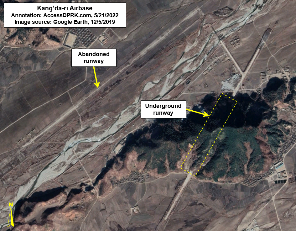
And lastly, Kang'da-ri AB (39° 5'48.78"N 127°24'51.67"E)

Like Onchon, Kang'da-ri also has an underground runway, but the facility doesn't appear to be actively used by aircraft, leaving Onchon as the only active underground runway in North Korea.

The Kang'da-ri complex consists of a primary runway on the left bank of a river and an underground runway. The primary runway was modernized in 2009/2010 but has since been abandoned and left to deteriorate each time the river floods. 

The underground history of Kang'da-ri goes back to 1998 when the initial excavations into the small mountain began. Work has carried on in fits and starts, with the most recent work appearing to have stopped in 2018.

The paved portion of underground runway is 1,748 meters, with ~750 meters of that actually being underground. 

It has been claimed that the base is part of the 2nd Air Combat Division, but no aircraft can be seen in any of the images available on Google Earth. Additionally, Joshua Stanton has said that the runway is too small for fighter aircraft. 

The true purpose of the base is unknown, but part of North Korea's chemical weapons program is said to be based at Anbyon, a town just 11 km away. However, there are few military facilities at Anbyon that would be suitable for chemical weapons storage, but the underground Kang'da-ri runway is protected by large blast doors and it cannot be directly accessed by any major highway - adding to the site's security. So I think the base is a candidate location for weapons' storage (chemical or otherwise), particularly since the government has seemingly taken 24 years to build an incomplete "airbase".


Unidentified large UGFs


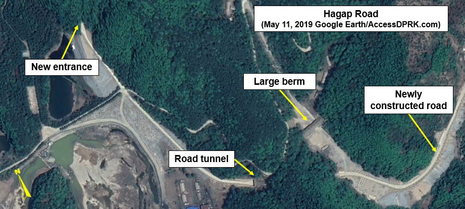
Hagap UGF (40° 4'54.23"N 126°11'22.74"E)

Hagap has been written about extensively (including on this site here & here), but it is in this section because we still don't know what the place is actually supposed to be. The two prevailing theories are that it's either an underground uranium enrichment plant or that it is part of the national archives.

The enrichment theory was put forward the moment Hagap became publicly known about in 1998. Given the construction of the Kangson enrichment plant near Pyongyang, and that Hagap still has not been completed, it would make its existence redundant (and very expensive) as an enrichment site. However, it could play any number of other roles within North Korea's nuclear program.

The other theory put forward is that it is meant to ultimately become an archives facility capable of protecting the most important documents and artifacts from even a nuclear blast.

After several years of apparently being dormant, new construction began at Hagap in 2011/2012 with a new underground entrance being excavated and the spoils were used to lay the foundation for an access road. This work was carried out methodically until in 2015/16 the pace of construction was sped up and new work could be seen throughout the eastern side of the complex. 

This construction coincided with underground work being carried out at the International Friendship Exhibition located a short 8 km away. The IFE is where North Korea houses the countless gifts, medals, and awards given to the country's leaders over the decades and is used in propaganda as proof of the greatness of the Kim family. 

Concurrent construction at both sites could merely be coincidence, but I think it might add a little weight to the theory that Hagap is actually meant to be part of a highly secured national archives, perhaps holding the true histories of Kims and government that are too dangerous to be accessed by anyone but the most devout followers of Juche or that it will hold the foundational documents and artifacts of the country to protect them from war or natural disaster.

Based on the locations of the underground entrances, there is a primary tunnel capable of handling vehicle traffic that runs for ~500 meters. The facility very likely also extends within the mountain for another 400-500 meters.


Sonjesan UGF (39°18'46.95"N 125°55'33.74"E)

Sonjesan is an interesting site. It is located in a random hill halfway between Pyongsong and Sonchon. It has no obvious industrial infrastructure or particularly tight security. At the same time, the roads leading to the UGF also go through multiple nearby military facilities, and it has four entrances.

The main entrance is at 39°18'46.95"N 125°55'33.74"E but the above image is centered on the two rear entrances at 39°18'35.52"N 125°55'50.47"E because they show up the clearest in the available imagery.

Connecting the four entrances into a simple rectangle yields a potential area of 95,700 sq. m., that's over a million square feet. Sonjesan also has visible spoils piles and examining those shows that at least 100,000 cubic meters of material has been excavated out of the hill. 

In 2020, the original buildings at the main entrance were demolished and new ones built. Another point of excavation that is almost certainly connected to the primary UGF was also opened in 2016, with the spoils pile growing each year into 2021. The pile contains approximately 6,300 cubic meters of material.

A nearby sixth site was constructed in 2017/18 at 39°18'14.84"N 125°55'40.66"E, along with a new military base, but I'm not sure if this tunnel connects to the main facility or if it's simply its own small UGF. 


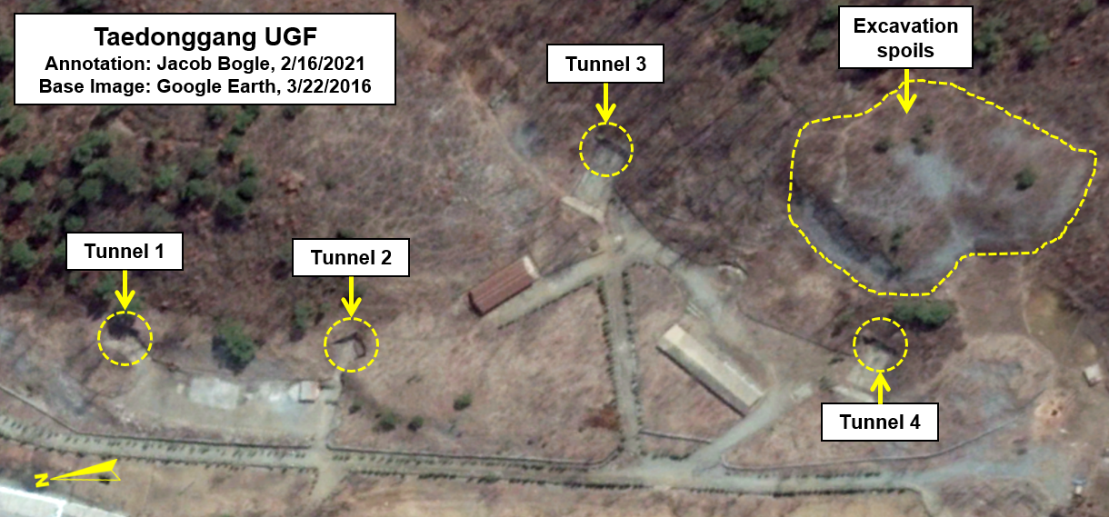
Taedonggang UGF (39°10'25.07"N 125°56'43.60"E)

Located by the Taedong River, near the Kangdong Leadership Residence, its four entrances are spread out along nearly 300 meters and the site could also be connected to a large artillery position 520 meters away that itself has an underground component. 

The four entrances are grouped into two groups and I don't think they're connected to each other. So the actual underground facility may not technically be among the largest because of this, but the overall complex itself it rather large. The particular layout of the UGFs is also uncommon.

The roads leading to the entrances are also quite wide and would allow access to vehicles that have wide turning radii such as missile launchers or large artillery systems. 

Interestingly, at the end of the base is a large overhead crane, such as one might see at a containership port or factory. New buildings were added at the crane site in 2019. The presence of the crane could suggest that the base is, in fact, used more for storage and maintenance (perhaps even of industrial equipment) than as an active missile or artillery base. 


Abandoned/Unsused UGFs

The Kyongje-dong Bunkers 38°34'36.46"N 125°56'8.15"E


The bunker complex at Kyongje-dong are one of the more enigmatic facilities in North Korea. The two bunkers are much too large to have been purpose-built for missile launchers, they don't extend deep enough into the hillside to be a typical storage facility, and they aren't part of a factory or other industrial infrastructure. 

Joseph Bermudez and Victor Cha over at the Center for Strategic and International Studies helped to shed a good deal of light on the bunkers. It is perhaps the most detailed open-source report on them.

The initial preparations for construction took place in the 1980s, but primary excavation work began in 1993. The facility was completed in 1998.

The two bunkers have entrances 40-meters wide, and they each have a large concrete pad in front that measures 60 by 40 meters. The entrances are protected by blast doors, and the earth-covered bunkers themselves are approximately 60 meters long.

The CSIS report goes on to say that the facility is most likely a reserve site that would serve as a forward operating base for MD-500 helicopters in the event of war, allowing special forces operations to penetrate much further into South Korean territory than other existing heliports would allow.


Hamhung abandoned UGF - 39°59'50.27"N 127°42'52.09"E


This site is 17.5 km northeast of downtown Hamhung. When I first came across it, I thought it was a mine, but a closer inspection of the main area reveals what is apparently a large tunnel protected by what can only be described as blast doors.

Looking at historical imagery on Google Earth shows that work began at the site in 1996 and work was ongoing in 2008. The UGF sits at the end of a valley, with the rest of the valley filled with numerous support buildings spanning 1.7 km. But by the early 2010s, work was halted. Nearly all of the buildings were then removed in two phases, one in 2016 and the other in 2021.

The primary tunnel face is ~45 meters wide and there is what looks to be a large metal frame to hold protective doors. A second entrance was created but has since been closed, possibly as the result of rock collapsed. 

The crane that was used to move materials into dump trucks has been kept in place.

It's still possible that the site used to be a mine, but if so, its design is unique in North Korea. If it was meant to be an underground facility, I think geologic problems developed as they dug deeper into the mountain, perhaps causing severe leaks or internal collapses. This wouldn't be the first time a UGF in the country had to be abandoned due to collapse. A coastal defense battery had a large cave-in back in 2016.


I also want to add an honorable mention to the network of tunnels that protect the Kim family. These road and rail tunnels connect various palaces and military command centers together, enabling the Kims to move around the country securely during a time of war or to evacuate one place and get to another. Most of this network is still hidden but there are some known/suspected parts of it that rise to the surface and can be seen by all.

One tunnel is particularly well known. It is a two-lane paved road (39° 9'50.83"N 125°59'26.98"E) that dives beneath the Taedong River near the Kangdong Palace and then reemerges a kilometer away. It is surmised that there is another tunnel that pulls off from the main one and connects to other elite areas in the region.

Another part of the network uses the country's railways. The Obong-ri Elite Train Station (40°18'18.13"N 125°12'18.72"E) is positioned in a mountainous region north of Kusong. The entire complex encompasses roughly 17 sq. km and contains two train stations, housing for personnel, various support structures and it has two rail lines that go into a hill and disappear. It is not known if this is simply an underground train repair center or if the lines continue underground and could carry Kim Jong-un many kilometers away on his armored train without anyone knowing.


I would like to thank my current Patreon supporters: Amanda O., GreatPoppo, Joel Parish, John Pike, Kbechs87, Russ Johnson, and ZS. 

--Jacob Bogle, 6/5/2022

Thursday, February 18, 2021

What Lies Beneath the Underground Republic

The internal workings of North Korea largely remain a secret to many in the world, and even Western intelligence agencies have bemoaned the relatively sparse amounts of information that flow out from the DPRK's borders. It's even suspected that the United States has no more than two or three low-level spies in the country - if there are any at all. This means that one of the main sources of information about this "hermit kingdom" comes from what can be gleaned through a vast array of satellites. 

One thing that becomes clear from these spies in the sky, is that North Korea has a fetish for digging.

During the Korean War, Kim Il Sung and his army witnessed the terrible and far-reaching ability of the Allied air forces to knock out military and economic targets from the sky. The northern part of the Korean Peninsula had been turned into Korea's industrial and most developed region by Japan during their 35 year occupation, but by the end of the three year Korean War, upwards of 85% of all buildings in North Korea had been completely or partially destroyed. The Korean War saw more tonnage of bombs dropped than in the whole of the Pacific Theater of WWII.

Kim Il Sung's expectation that Korean War II was imminent, and based on the lessons he learned during the first war, led to him commanding that the whole country be fortified, saying in 1963, "we must dig ourselves into the ground to protect ourselves"

The practical results of this are the countless miles of trenches along nearly every hill, a coastline ringed with artillery positions and anti-invasion obstacles, the second largest combined military and paramilitary force in the world, and lots and lots of tunnels, bunkers, underground factories, and other sites constructed beneath the surface and out of view. 


At this point, I want to sound a note of caution to those who like to let stories of North Korean mysteries run away with them. There has been plenty of speculation about the true extent of North Korea's underground infrastructure, with some going so far as to claim that most of their military bases are actually buried beneath the ground. The truth is, while both small and vast underground sites exist across the country, commercial satellite images do not support the idea that there's basically a parallel country underground. 

Military sites are easy to find if one knows what to look for and reviewing current and historic satellite images only reveal underground sites at some of them, and most of those are relatively small.  The only way you could claim that most bases have an underground facility (UGF) is if you include small storage bunkers or gun emplacements that are situated a few meters into a hillside. But I don't accept the definition of an "underground facility" as merely being "any usable structure with an inch of dirt on top". For the purposes of this article, UGFs are a sizable structure built into the ground, where the rock cover would provide meaningful protection from bombs and missiles.

Aside from military sites, major factories with UGFs are likewise easy to spot. I have looked at every square meter of the country more than once, and the 2021 AccessDPRK Pro Map is swollen with over 13,000 distinct military-related sites plus dozens of factories with an underground component. However, to reiterate, I haven't seen anything in commercial satellite imagery that convinces me there is a nationwide system of connected tunnels and underground sites.


Based on the AccessDPRK 2021 Map, Pro Version, the country has over 1,500 identifiable tunnels and underground facilities.

The sheer number of these sites overall is a little mind-boggling when you consider how relatively small North Korea is. The above map shows each of the 1,500+ tunnels and important underground facilities that I have managed to locate, as well as coastal batteries that have a clear underground component. It doesn't show the 850 hardened artillery sites, 492 drive-thru bunkers, or other installations that only have small access tunnels. The total number of large and small UGFs (which includes artillery sites and small storage areas) is estimated to reach as high as 14,000. 

Some sites were clearly constructed decades ago and were either abandoned or serve as emergency facilities in the event of open warfare. Because of this, their entrances have become overgrown with vegetation and that can make identification difficult. Furthermore, others have indeed been abandoned and mining operations or other domestic activities have encroached on the site; I saw little need to map those. 

There are also scores of stories about secret underground escape routes that connect Pyongyang and major palaces with underground rail lines that would allow the Kim family and top officials to be spirited away to the far north of the country, and even to China.

According to a 2015 report, the US military has mapped 6,000 to 8,000 of these "VIP" underground sites that North Korea's leadership could use to either hide or escape the country. The vast majority of them, however, would be simple bomb shelters (something that is common in South Korea, too). And, while this report lends credence to the idea of large, interconnected networks of underground facilities, the problem is that there is almost no direct visible evidence in the public sphere for such a massive system (although smaller tunnel segments have been identified). Additionally, this system is for the country's top leadership and isn't part of the normal domestic and military infrastructure of the country. So, this article is only going to focus on other underground infrastructure that plays a more "daily role" in the country.


While the exact purpose of each and every one of the sites is impossible to ascertain by simply looking at them from the air, most tend to fall into a handful of categories. There are a few major underground facilities, such as the Punggye-ri Nuclear Site, the Panghyon underground aircraft factory, and Kim's hardened helicopter base (which is part of a much larger underground command and control base). Most of the others can be classified into these: the underground factory or laboratory, the unspecified underground facility (many with protective berms at tunnel entrances), underground facilities at Navy and Air Force bases (excluding HARTS and storage bunkers), and basic tunnels (either individual tunnels or usually in groups of three).

The following set of images shows examples of various types of underground facilities. The satellite images used cover a large range of dates, but they were chosen because they best showed the sites in question.

Click on any image for an enlarged view.

The Hagap Facility in Chagang Province (40.081644° 126.189346°) is an example of a major underground site. Its exact purpose is unknown, but the two main theories are that it's either part of North Korea's nuclear program or a secured storage site for important government archives. Construction of the site has been ongoing for decades, punctuated by periods of inactivity, but since 2016, work has been steady.


Ryoho-ri Underground Naval Base (39.876051° 127.785328°)

This is a submarine base and the headquarters for the East Sea Fleet. It is one of 13 naval bases that have an underground or hardened facility. Ryoho-ri has two underground entrance points and suggests the existence of a large underground facility at least 300 meters in length and that could likely extend a further 150 meters into the hill. 

Ryoho-ri is so important that Kim Jong Il had a villa built nearby and both the villa and base have special rail access.


Pukchang Airbase (39.512137° 125.958563°)
Pukchang is one of 22 airbases and heliports that have associated underground facilities. I've already written about two of these in detail, the Sanghung-dong VIP Heliport in Pyongyang and the Kangda-ri Airbase near Wonsan. 

Pukchang is home to a Mig-23 fighter wing and has three main underground entrances into Obong Hill. It is also adjacent to the Yonggang-ni Helibase which has its own small UGF. 

Such facilities are used to store important aircraft and equipment, conduct maintenance, and at some airbases, even engage in manufacturing parts.


Tonghungsan Machine Plant (39.953611° 127.546918°)

Located in Hamhung, this is a major underground factory and is associated with North Korea's arms industry. Beginning in 2016, major reconstruction work began on both the underground portion and the external buildings. This reconstruction kicked off a series of new building and renovation projects at multiple arms facilities around the city including the Chemical Materials Institute and at the Hungnam Fertilizer Plant which produces chemicals used in various programs. 

Depending on Tonghungsan's exact size and layout, parts of the factory could be protected by over 150 meters of rock.


Taedonggang UGF near Pyongyang (39.174538° 125.946416°)
This is underground facility has a publicly unverified purpose. Located 6.5 km across from the Kangdong Residence on the other side of the Taedong River, it consists of four entrances divided into two sections. Tunnels 1 and 2 appear to be more for underground storage, while the size and configuration of the road and tunnels 3 and 4 suggest that they're for larger equipment (possibly TELs and MRLs).

Based on rough calculations of the volume of the spoil piles, there is at least 40,000 cubic meters of interior space for tunnels 3 and 4. That's the equivalent of a room 63x63 meters in size with 10-meter-high ceilings. The existence of a gantry crane and dedicated electrical substation can also clue us in to what purposes the site may be used for.


Pyongyang Armed Forces District UGF (39.059308° 125.733921°)
One of the largest identified underground facilities is beneath a hill in the middle of Pyongyang. One of the oldest entrance points is located at 39.059308° 125.733921° and is next to a secured villa. The tunnel can take VIPs into the facility that occupies a large portion of the hill or across the hill to the Sanghung-dong Heliport, where six helicopter hangars are protected by steel blast doors and hardened walls. 

Roughly 660 meters northeast from the original entry point is the newest entrance. It was added in 2017 and can take important people from an assembly hall directly into the UGF. 

This Armed Forces District UGF is one of multiple hardened command and control facilities within the city. 


While North Korea's engineers are capable of constructing large underground factories, they're still limited by the technology, education, and other factors that they have access to. North Korea is well known for their "speed campaigns" and for constructing large projects rapidly. Lack of enough materials due to sanctions and additional factors means that some of these projects end up shoddily built, with problems arising often and even occasional building collapses. These failures can also extend to military sites.

The following site is a coastal artillery position in North Hamgyong Province (41.896007° 129.950076°) that suffered a collapse, largely destroying the site.

Area before the collapse.


Area after the collapse.


North Korea built one of the deepest subway systems in the world, and they have a history of building underground facilities not only within their own borders but also around the globe. 

These places aren't just for hiding weapons or keeping the Kim family safe. Four massive tunnels that traversed the DMZ into South Korea are known about and some estimate that fifteen to twenty others could exist. Such infiltration tunnels could enable an invasion into South Korea with tens of thousands of soldiers and vast sums of equipment without warning.

From infiltration tunnels to escape routes 100 meters underground to new UGFs at ballistic missile bases, the difficulties in discovering this underground infrastructure and combating its ability to hide people and weapons present a continuing obstacle to intelligence. It may also provide a potentially unacceptable level of uncertainty regarding any offensive strike against the country by the United States or South Korea, as they may not know where each target person is exactly or if every nuclear bomb or technological site was hit. 


I would like to thank my current Patreon supporters: Amanda O., Anders O., GreatPoppo, Joel Parish, John Pike, Kbechs87, Planefag, and Russ Johnson.

--Jacob Bogle, 2/17/2021

Sunday, September 1, 2019

Work at the Hagap Underground Facility Continues

Hagap is a large underground facility that lies right across the provincial border in Chagang Province, near the International Friendship Exhibition (in North Pyongan Province).

Landsat/Copernicus satellite imagery shows that Hagap was constructed in 1991 (although it seems the US intelligence community didn't learn about it until 1996). By 1998, within the public sphere, Hagap was suspected of being one of North Korea's centrifuge facilities and was often mentioned in the same breath as the site at Kumchang-ni. At the time, the Defense Intelligence Agency said, "There is one site, of an unconfirmed function, that possibly could be a nuclear-weapons-related facility by 2003...The function of this site has not been determined, but it could be intended as a nuclear production and/or storage site."

Changes at the Hagap site are visible between the 1990 and 1991 images.

Hagap, as with Kumchang-ni, seems to never have been completed and certainly never became a functioning nuclear site. But questions started being raised about Hagap, specifically, despite the initial insistence by the Pentagon that it was a nuclear site. These questions were made more relevant by the fact that, after being inspected by an international team, Hagap didn't appear large enough or well suited to house a nuclear reactor or serve other related purposes.

As mentioned earlier, Hapag is near the International Friendship Exhibition, a mere 5 km away. This and other reasons (some I mentioned above) has led to some analysts calling into question its nuclear purpose. The other idea is that it's actually being turned into a massive records storage complex; Pyongyang's answer to Iron Mountain.


In 2017 I first reported on new work being conducted at both Hagap and at the IFE. The construction at both sites seems to have begun in 2016 and continues to this day. Before I get into the alternative purpose for Hagap, I want to go over these ongoing changes.


The above image shows the site as it appeared in October 2013 and after work had resumed in October 2016, after many years of apparent inactivity. The main difference is a large pile of excavated debris.


Aside from the pile of excavated material, additional areas of activity could also be seen around the site.


By 2019 what the "other activity" was turning into became clear.


The large pile of rock was in fact debris from tunneling operations to create a new entrance to the site that would allow vehicles inside. The other activity was the construction of a road that led into the facility.


The new entrance site is very clear on this April 10, 2019 image.

Access to Hagap is a small access road that comes off the Pyongyang-Huichon Highway. There is no obvious security gate or fence system that surrounds the complex. This leads me to suspect that it isn't an important nuclear-related facility. While there are coincidences in timing between construction periods at Hagap and construction periods at known nuclear sites, that's about the only similarity.

And even as a weapon's storage site, Hagap seems to be ill fitted. For one, having a central storage site for your most important weapons isn't a good idea. A major strike could wipe them all out. Secondly, Hagap is at least 50 km away from the nearest suspected ballistic missile base. Moving weapons to there from Hagap, up and down winding, unpaved roads, would leave them vulnerable to observation and attack for extended periods of time.

The other two suspected nuclear sites, Kumchang-ni (in North Pyongan Province) and Yeongjeo-ri (in Ryanggang Province) are both positioned far into a closed valley and cover large areas. They have support buildings spread throughout and have perimeter security. The same can be said for nearly all of North Korea's ballistic missile sites. And while Yongbyon isn't hidden, it is surrounded by air defense and has multiple security fences and checkpoints. Hagap doesn't have any of these things, and though it is tucked away in a valley, it only takes up a relatively small footprint, plus it's just a mile off the main highway and doesn't appear to have any military units on-site to provide protection.

Hagap does have housing but they're not typical "harmonica houses" or in barrack form (both styles dominate military housing). They're small apartment blocks next to what may be administrative buildings. And finally, work has been taken to "beautify" the area with tree-lined roads, ponds, and a lovely central building at the main entrance. On the other hand, Yongbyon looks like any factory town and the uranium plants at Pakchon and Pyongsan are plain industrial sites. Only the Kim's are worthy of a forested campus.


Whether Hagap was envisioned to be a nuclear or research facility that was later re-purposed into an archival facility or whether it was always supposed to be an Iron Mountain we may never know, but the site's rural location and it being underground mean that anything inside would be likely to survive even the most catastrophic of wars or rebellion. And with all of the "gifts" being transported to the IFE, Hagap is nearby to receive more serious cargo. After three generations, Kim Jong Un is having to save the country his grandfather created. He must also ensure that the history of the country (both official and real histories) is saved. Hagap looks to be the perfect place for that.


I'd like to thank my supporters on Patreon: Kbechs87, GreatPoppo, and Planefag.

--Jacob Bogle 9/1/2019
Patreon.com/accessdprk
www.JacobBogle.com
Facebook.com/JacobBogle
Twitter.com/JacobBogle

Thursday, January 12, 2017

Activity Spotted at Possible Nuclear Site

There's a massive underground complex hidden away in the hills of North Korea. For years it has laid dormant (as far as one can tell), that is until recently. The facility at Hagap (40° 04′ 48″ N, 126° 10′ 56″ E), is a suspected underground nuclear site, either to store material or produce it.

According to Dr. Jeffery Lewis, at Armscontrolwonk.com, the site became publicly known in 1998 (the US government knew about it since 1996) and was constructed at the same time as another underground site, Kumchangni (40° 7' 8 "N 125° 8' 32"E). Since such a site could possibly violate the bilateral 1994 Agreed Framework, North Korea didn't say a word about the place. After the site became public, the US managed to send a delegation to visit it. They didn't find much besides an oddly designed underground facility.

The debate about what exactly is going on at Hagap continues to this day. It has been speculated that the site is used for nuclear materials storage, centrifuge production, or even just a large secure warehouse for archival materials. However, the connection with Kumchangni still remains. There is a third site too, at Yeongjeo-ri (Ryanggang Province), but little is known about it.

North Korea's nuclear program has been ramping up since the final days of Kim Jong-il, and Kim Jong Un seems to be increasing that pace. In the light of that, it is disconcerting to see fairly substantial new activity happening at Hagap.

(Click image for larger view.)

At the site you can see a large mound of new rock debris which has been piled up in the pond below the main entrance. You can also see an increase in the number of small buildings and debris that are in the small valley.

Here are some closeup images:

This one shows the debris mound.

This image shows the extended activity area with new buildings.

There is also an odd collection of towers nearby. They look like electrical transmission pylons, but are clustered together into three groups. There are no visible power lines either. It's possible these were laid out when Hagap was originally constructed to provide power, but haven't been needed since the site was largely abandoned. Or they could be some kind of radar/communication array. The towers are located around a bend in a river with small hills on either side, those hills have an anti-aircraft artillery battery stationed on each one. If you'd like to study the area further, it can be found here  40° 4' 50"N 126° 6' 35"E.


--Jacob Bogle, 1/12/2016
JacobBogle.com
Facebook.com/JacobBogle
Twitter.com/JacobBogle