Showing posts with label missiles. Show all posts

Saturday, September 24, 2022

In North Korea Thousands of Guns Point to the Sky

North Korea has the densest network of air defense sites in the world, and their mix of low-level anti-aircraft artillery (AAA) systems, Soviet-era surface-to-air missile (SAM) bases, and early warning radars still pose a risk to adversaries. 

An M-1983 Quad 14.5 mm anti-aircraft gun being shown during a parade in this undated image.

Between the AAA and SAM batteries, over 1,500 fixed air-defense sites are arrayed to protect North Korean airspace (squeezed into an area half the size of England). 

In this article I will focus on the current capabilities of the county's anti-aircraft artillery, but I'll also touch on their surface-to-air missiles as well.

Under the control of the KPA Air Defense Command and Pyongyang Antiaircraft Artillery Command, North Korea's AAA defense are made up of M-1983 Quad 14.5 mm guns, ZU-23-2 twin barrel autocannons, M-1992 Twin 30 mm autocannons, and M-1992 Twin 37 mm self-propelled guns.

These guns have a practical rate of fire of between 150 and 1,600 rounds per minute per barrel, with effective ranges of 2.5 to 5.8 km depending on which system is being used. 

AAA batteries are typically laid out in two arrangements, the "daisy" and what I call the "I".

Example of the "daisy" layout.

Daisy arrangements refer to a circular configuration of guns. They range in size from 4 to 12 guns and may form a "chain" of daisies, with 2-3 sets of four guns each or they may simply be a single circle of guns. 

According to George Herbert, adjunct professor at the James Martin Center for Nonproliferation Studies, AAA guns in this arrangement lie within a targeted environment (such as near the Yongbyon Nuclear Center) and can protect it from threats coming in from any direction.

Example of the "I" layout.

The second primary arrangement for AAA guns is "I". These are just a single straight line of guns. All but one of the "I" layout sites deploy 8 guns.

Mr. Herbert explains that this arrangement is best for firing at aircraft that still lie outside of the main target, such as on the approaches to Pyongyang, but before they actually enter the city's airspace, and can concentrate the fire from multiple guns onto the enemy aircraft.

There are 70 of these surrounding Pyongyang in an oval ring 25-30 km outside of downtown.


A Layered Defense

The country's air defense is constructed using a layered approach. The DMZ and each coast has a line of AAA batteries along them with the main coastal cities then being encircled by their own ring of defenses. Interspersed in other parts of the country are the batteries for major KPA bases, navy and air bases, missile sites, industrial centers, and key palaces. There are also a few others scattered around the country at seemingly random sites. 

Nowhere is this layered defense more obvious than at Pyongyang.

As the nation's capital city, Pyongyang is the largest population center, is where all of the main military command centers are located, and it contains the greatest concentration of industry making its capture a primary goal in any war.

Pyongyang has over 400 AAA batteries arrayed in three main lines of defense, and it is also protected by two outer rings of 19 surface-to-air missile batteries as well.

Illustrative map of the main AAA and SAM defensive ranges (approximate distances) around Pyongyang, with the Ryongsong Palace highlighted in blue. The yellow ring is the palace's dedicated air defense ring.

Within Pyongyang is also the Ryongsong Palace complex. Nestled within Pyongyang's air defense space, the palace is surrounded by its own dedicated ring of AAA batteries and is covered by at least 5 nearby SAM batteries, making the palace perhaps the most well-defended single site in the world.

Other areas that enjoy substantial air defense are Nampo, Sariwon, the Yongbyon Scientific Nuclear Research Center, Haeju, Kaesong, Wonsan (which is also home to a Kim palace), Hamhung, Kanggye, Chongjin, Tokchon, and the elite Samjiyon-Mt. Paektu area.


All of these overlapping clusters also end up creating a thicket of AAA sites within the "Kaesong-Munsan" invasion corridor. This would be the most contested stretch of airspace as it is the most direct path from connecting the capitals of North and South Korea. The corridor is roughly 50 km wide and 155 km long, stretching from the DMZ up to Pyongyang. 

Map of invasion routes including the two Kaesong approaches. Image: Marine Corps Intelligence Activity, North Korea Country Handbook, May 1997.

In any given 5 km circle (the maximum range of most AAA guns) a pilot would only have three, perhaps four, brief moments where they weren't in range of any guns if they were flying through the center of the corridor. Of course, where AAA may not reach there are still the dozen+ SAM sites that lie within the corridor and whose ranges are between 25 and 300 km depending on the missile system being used.


Point to the Sky

Nationwide, North Korea currently has 1,463 active AAA sites. These batteries have the capacity to field 8,641 individual artillery pieces. Each battery consists of anywhere between a single gun to up to 12 guns. The majority fall in the 6-8 gun range. Not every fixed position has a gun in it at all times, but around 90% do. This means that at any given moment there are 7,777 artillery pieces ready to fire.

There are also 521 known decommissioned sites. Having decommissioned sites mapped is important, particularly within the public sphere, in order to have accurate maps available. Many of these older sites haven't been demolished, merely closed, and so they still look like they could be used. That has led to some of them being incorrectly identified as active on other databases (like OpenStreetMap and Wikimapia).

Additionally, knowing when sites are closed or newly constructed allows researchers to better track trends in air defense strategies (among other things).


Surface-to-Air Missiles

Map of current SAM positions.

The country also maintains between 57 and 61 surface-to-air missile batteries, with two of them being modern constructions. Most field S-25, S-75, and S-125 systems that are from the Soviet-era. North Korea has attempted to develop their own SAM systems with the KN-06 and KN-30 which are clones of Russian S-300 and S-400 SAMs. However, despite being promoted in official state media, these mobile systems haven't yet been verified to have been fully deployed through open-source imagery and publications.

If they are being used, they would most likely first be sent to the new SAM batteries constructed at Wonsan (39° 7'16.21"N 127°44'16.26"E) and near the town of Haeju (38° 5'28.79"N 125°27'2.18"E).

Between AAA and SAM sites, approximately 75% of all of North Korea's airspace is covered using conservative measurements. The largest gaps in coverage are in the highly mountainous border areas with China and access to those gaps would require either flying in from China or making it through already defended areas.


An updated explorable map of North Korea's air defense sites is available through purchase of the AccessDPRK Map (Pro Version)


I would like to thank my current Patreon supporters: Amanda O., GreatPoppo, Joel Parish, John Pike, Kbechs87, Russ Johnson, Squadfan, and ZS. 

--Jacob Bogle, 9/23/2022

Wednesday, October 2, 2019

Missiles and Monuments

North Korea has been touting itself as a strong, powerful, socialist nation for generations. That propaganda, however, has largely been devoid of reality. That is, until the newest incarnation of the divine Paektu Bloodline arrived to save the people of North Korea. Whatever caricatures may exist of Kim Jong Un being a squat, little "rocket man" with funny hair and whatever very real criticisms exist of the terrible human rights situation in the country, the fact is undeniable: Kim Jong Un has fulfilled the nation's long promoted promise of turning North Korea into a nuclear-armed state with a credible missile deterrent.

While the country has had a missile program for decades, the main propaganda surrounding those developments were limited to posters, songs, and "documentaries", even when progress was made under Kim Il Sung and Kim Jong Il. However, satellite imagery shows that Kim Jong Un feels he deserves something more long lasting, something written in....stone.

Kim Jong Un has tested more ballistic missiles than both of his predecessors combined, and key milestone launches have now been commemorated with monuments of stone. These monuments center on launches carried out in 2017, North Korea's "miracle year" in which they tested missiles capable of hitting all parts of the United States and tested their largest nuclear bomb to-date.

There are five of these launch commemorations known, with the latest one being under construction as of May 2019. The fact the regime is still building these monuments may contradict their claims to have accomplished a nuclear deterrent (at least to their satisfaction) and contradict occasional claims that the government will begin to move away from the "two track" system (developing the economy and nuclear weapons in tandem) to focus on the economy, as it shows Pyongyang is still placing a new level of emphasis on these weapons. (Not to mention all of the other worrying signs that North Korea has no intention to denuclearize.)

I want to give a quick shout out to Joseph Bermudez and Victor ChaJeffery Lewis, and Dave Schmerler for their respective work on individual monuments.


1. Missile tested: Pukkuksong-2. Date: Feb. 12, 2017. Location: Iha-ri driver and vehicle test facility,  40° 0'47.38"N 125°13'22.21"E.


The dimensions of the monument space is roughly 24 m x 19 meter, while the monument itself is a small stone about 2.5-3 meters.

The location of the monument is actually ~320 meters away from the launch site. The test stand that was used was one of the sites demolished in hopes of helping relations between North Korea and the United States.


2. Missile tested: Hwasong-12. Date: May 14, 2017. Location: Kusong, No. 112 Factory, 40° 3'56.61"N 125°12'34.45"E.


The monument foundation first appeared in October 2018. The fact it hasn't been completed by now suggests the work has been suspended for some reason. The concrete pad is approximately 27 meters long. The wider section (left-side) is 10.5 meters wide and the thinner, longer section is about 8 meters wide. Some of the commemorative monuments incorporate the launching pad itself into the overall monument site, so the thinner, longer section could be it.


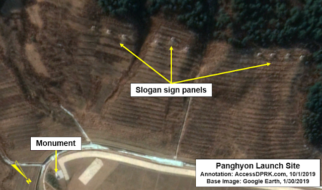
3. Missile tested: Hwasong-14. Date: July 4, 2017. Location: Panghyon Aircraft Factory, 39°52'19.48"N 125°16'10.85"E.


The test happened within the grounds of the Panghyon Aircraft Factory, some 6.5 km southeast of the Panghyon Air Base. Kim Jong Un called the test a "gift to the American bastards" on America's Independence Day.

A second monument was constructed at the observation post located a kilometer away, but it was later demolished. Currently, this is the only stone monument at the site. Across from the monument, up the hillside, is a slogan sign that was also erected after the test. Unfortunately, the image isn't of sufficient quality to know what the sign says.


4. Missile tested: Hwasong-14. Date: July 28, 2017. Location: Mupyong-ni, No. 65 Factory,  40°36'39.56"N 126°25'32.92"E


The location of this launch may be referred to as Mupyong-ni, which is the name of the local village, Jonchon, which is the name of the city this is in, or Factory No. 65, which is the name of the missile factory the launch actually took place in.


5. Missile tested: Hwasong-15. Date: Nov. 28, 2017. Location: Near Pyongsong, 39°18'58.25"N 125°52'58.08"E.

The Hwasong-15 missile is North Korea's longest-range missile that has been tested. It is theoretically capable of hitting nearly all of the US mainland. Not surprisingly, the monument to the launch is the largest of the five.


Including green space, the monument's area is 75 x 61 meters. The launch site occurred 4 km north of the March 16 Factory in Pyongsong. The factory produces a wide array of military vehicles and supports the missile program by either manufacturing or modifying launch vehicles. According to 38 North, "it was revealed that the building and temporary shelter were used to modify the Hwasong-15 TEL and test the operation of its elevation cradle and detachable launch table for the November 28, 2017 test launch."


One thing that I have found interesting is the variety of locations where North Korea has tested missiles. Factories, fields, vehicle test ranges, beaches, air ports, and even places that are actually dedicated to missile launches like at Hodo. These tests are not only to show that the country has the needed capabilities to successfully launch them, but the range of testing locations is a none-to-subtle message to the world that they are able to do so from any part of the country, not just from military bases or sites with purpose-built infrastructure.


I would like to thank my current Patreon supporters: Kbechs87, GreatPoppo, and Planefag.


--Jacob Bogle, 10/1/2019
Patreon.com/accessdprk
www.JacobBogle.com
Facebook.com/JacobBogle
Twitter.com/JacobBogle

Sunday, April 28, 2013

New Military Constructions for Artillery

I was going about my business mapping North Korea when I came across an odd set of trenches, and then more of them and more. After looking at their design it became somewhat obvious that these were new hardened emplacements for artillery.

This map gives you a broad view to help you understand their location with respect to well-known cities and islands.


In all I found 21 new sites as well as 1-2 more in the process of construction. Some of the placemarks represent two sites which are side-by-side, in total there are 24 of these "tunnels."

Here is a close-up map of all of the new locations:


The one in the center of the group can be found at 37°48'23.31"N 125°28'5.17"E. All of the other ones are within 1.5 miles of the center.

They all have the same layout, a curved entrance with a "pad" in front and they're all dug into the sides of hills. This is a detailed image of several of them in a cluster.


Each entrance is 21-24 feet wide and from the entrance to the access road is around 100 feet. All of the access ramps are aligned so that the entrances are either facing the north or west.

Also, the area has had a fair amount of new construction with new roads and new buildings.

Here is the central region on Nov 25, 2011:


The same area except on June 20, 2012:


A close-up of some of the buildings:


And finally, a detailed image of the northern most region:


Based on the dates for the past imagery this entire project was built in less than a year. The location of this facility is less than 14 miles from Yeonpyeong Island, SK and less than 61 miles from Incheon International Airport and mainland South Korea.

This has been a rather unpleasant discovery.


--Jacob Bogle, 4/28/2013
www.JacobBogle.com
Facebook.com/JacobBogle
Twitter.com/JacobBogle