Showing posts with label burial mound. Show all posts

Thursday, July 23, 2026

Traditional Burial Grounds Emptied in Wake of DPRK Policies

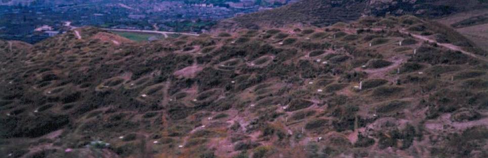
North Korea's hillsides host countless burial mounds in clusters ranging from just a few burials to many thousands. 

These irregular cemeteries have been a common feature of mourning and remembrance for generations. But due to government orders in 2024 to help promote reforestation efforts, thousands of burials have been exhumed around the country and numerous mounds have been flattened by authorities.

This report reviews nine burial locations across five provinces and Pyongyang that help illustrate the extent of the policy's effect at present.

Uncredited image of traditional burial mounds on a hillside North Korea. Source: North Korea Economy Watch.


Hillsides have always been a preferred location for burials, and a casual glance at hills in both North and South Korea can reveal countless small mounds of the dead. But in North Korea, this practice took on a whole new importance during the 1994 famine that killed upwards of a million people as space in sanctioned burial grounds grew sparce and cremations remained unaffordable for many.

The famine itself was exacerbated by widespread deforestation caused by the need for firewood and in attempts to expand crop growing areas, but that only resulted in the topsoil being rapidly washed away, enabling floods to be stronger and causing crop yields to drop.

The resulting deaths and burials on the hillsides mean that on top of nearly every denuded hill near cities and villages are countless burial mounds. Some are dutifully tended to by living decedents and others have been forgotten as family lines die out, memories fade, and populations move.

The orders from Pyongyang allow for relatives to dig up and re-inter their loved ones, but for those graves that can't be emptied, local governments simply bulldoze them into oblivion. 

This process can be seen across the country, from the starting point of tomb's being opened to the end result of the mounds being flattened and the land repurposed.


The first example I'll show is from a small hill on the outskirts of Pyongyang.

Numerous open tombs are visible; their remains having been exhumed.


On this hill in Pyongyang's Sadong District, you can see a mix of intact tombs and many others that have been opened (next to each yellow line). Although the government's orders to clear irregular cemeteries don't dictate what families must do with the remains, we can presume that they are either cremated or reburied at an approved cemetery.

Despite my searches, there are only limited examples of burial mound removals in Pyongyang. Perhaps I simply didn't look thoroughly enough or perhaps such a move - to demand the removal of burials of members of the country's elite families - would have been politically fraught.

The next example is at Chungsan.

Google Earth images of hillside burial removals in Chungsan, comparing the site in November 2019 and in June 2025.

In Nov. 2019 the town's burial mounds were all clearly visible and intact but by June 2025 a large swathe of them had been totally removed, and many others emptied. This site represents the largest clearance of burials in Chungsan.

A June 2024 story by DailyNK reported that authorities had intended on the cemeteries to be emptied by the end of 2024. However, while the process of exhumation has spread, most of these hillside cemeteries still remain at least partially intact. 

Opened burial mounds in Songnim, 2025.

This hillside burial ground in Songnim is another representative of this clearance activity in a major city.

What isn't known is how long family members are given to enact the removals. Due to freezing winters, exhumations can only be carried out during certain times of the year, and they are most often done using manual labor. 

Nor is it known how families are notified that a certain area is slated to be reforested or converted into farmland. Comprehensive, centralized records are not known to be kept of these sites, so if a family is unaware, can't be contacted, or can't reach the site quickly enough, it's probable that many burials become forcibly lost forever.

Bongsan burial mound removals. 

In this example at Bongsan, east of Sariwon, you can see dozens of mounds were levelled at some point between 2022 and 2026, but quite a few still appear intact. 

Other small burial grounds exist in Bongsan and all have had at least some of the mounds removed, but none have been completely razed. 

Hillside burials in Chaeryong. A partial clearance of the mounds is visible. 

This Chaeryong burial ground shows a mix of intact tombs, emptied ones, and shows an area on the eastern flank of the hill that has been cleared entirely. 

North Koreans maintain traditional beliefs when it comes to death practices and consider family burial grounds to be sacred sites that should be honored. 

Throughout the year family members will check on the grave sites and clear them of debris, and there are specific holiday observances, such as Chongmyong on April 5.

During Chongmyong, families visit the graves of their ancestors, make offerings, and share in their remembrances. In atheistic North Korea, this is one of the few traditional events that still carries spiritual weight and is widely practiced. 

However, the burial clearances have begun to destroy those ancestral ties and diminish the ancient rites.

Before and after of tomb removals in Sampo-dong. 

At this single burial ground in Sampo-dong at least 160 graves have been removed between 2022 and 2025. Several hundred others have been removed in the immediate area.

Although one of the driving forces for removing these burial mounds is ostensibly to help reforest the nation's hills, low hills such as these are often cleared to expand farmland. And while gaining farmland is obviously a national need, one has to question if the price of a few extra hectares is worth the destruction of local sites of multi-generational remembrance?

Former burial ground in Munchon, Kangwon Province.

One of the more curious outcomes of the clearance process can be seen in Munchon.

After graves were emptied and the mounds removed, the area has seen deep cuts into the ground. There is a small site used as a quarry at the foot of the hill, so one wonders if what we were seeing at this site is the expansion of quarrying activity to now include the former burial ground.

Illicit farm in Munchon being reforested between 2020-2026.

It should be noted, however, that reforestation efforts extend to more than just burial grounds, and have impacted illicit hilltop farms known as sotoji

Further up the mountain from this burial ground, a ~1.3-hectare sotoji plot was planted over with trees in 2021-22. 

Cleared burial grounds in Kumya, South Hamgyong Province.

The destruction of burial grounds around the town of Kumya is among the most widespread and striking.

Just within the area shown, some 250 graves have been completely destroyed. Another 500 or so burials in several other plots within half a kilometer of this site have also been removed. 


Cleared burial ground in Hamju, South Hamgyong Province.

North, in Hamju, a further 200 burial mounds were removed. 


Despite the public account of when the burial removal orders were issued, some large-scale removals were already underway in 2023, and so local pilot programs may have preceded the establishment of a national policy.

Most countries have regulations for burials. Where, when, what kind, are all questions that are not only important to the family but are also important for things like public health.  

The proliferation of irregular burial grounds may have caused difficulty for North Korean authorities, especially on the local level, regarding things like land usage and trying to regulate the further erosion of hillsides. 

However, forcing the great mass of the population to not only exhume ancestors but to then give up grave sites that have played an important role in the sense of family continuity that such places engender seems particularly harsh. 

North Korea is already a place where family fealty must take a backseat to the state, and where even love for one's parents is supposed to be less than one's love for the Great Leader. Eliminating scores of burial grounds that have long served as communal focus points comes across as yet another attempt to further limit any sense of identity that may exist outside of the state.


I would like to thank my current Patreon supporters who help make AccessDPRK possible: Donald Pearce, David M., Dylan D., HG, Joe Bishop-Henchman, Joel Parish, John Pike, Jonathan J., Kbechs87, Russ Johnson, Squadfan, Timberwolf, Yong H, and 덕형이. 

--Jacob Bogle, July 23, 2026

Friday, August 19, 2022

Archeology in North Korea

I have written about the "lost history of Korea" before but I wanted to give an update as the original article is now eight years old and I've made a lot of mapping progress since then.

With the artificial division of Korea in 1945, both sides will have developed distinct modern archeological histories as the two sides have grown more and more distinct. But this division also left thousands of years' worth of joint Korean history within the confines of North Korea. As a result, numerous sites are largely unknown to the English-speaking world and much of the archeological research that was done prior to the division was done while Korea was under Japanese occupation, making it outdated and its results subject to the Imperial ideology of the day. Likewise, any research done in North Korea subsequently will be tainted by the current government's ideological narratives; and there are serious questions about the quality and reliability of North Korean archaeology as a practice. 

Most North Korea watchers are aware of some of the major archeological sites in the country. The ancient capital of Kaesong and the Royal Tomb Complex of the Koguryo Dynasty - both UNSECO World Heritage Sites. There's also religious relics around Mt. Myohyang, pieces and pavilions of the wall that once encircled Pyongyang, and the alleged tomb of Tangun, the legendary founder of Korea.

North Korea has a list of 193 sites designated as National Treasures, with these including major tombs, fortresses, temples, pagodas, and other tangible sites. There is also a list of 1,800 other culturally important items such as steles and sites that no longer exist. Unfortunately, most of these lack exact locations and are also small objects (steles and stone pagodas may not be visible at all by satellite), and so most of these locations have gone unmapped by AccessDPRK but I have endeavored to locate the ones possible.

Through the work for AccessDPRK, I've noted well over 400 historic sites. Additionally, I have located over 900 large burial mounds. Most of the burial mounds will date to before 1910 and could hold troves of valuable cultural, religious, and political history going back generations.

While many of these locations will likely be known to Korean historians and archeologists, most will not be known to English speakers and there's very little information about them in English. 


I've been able to map enough sites, that the paths of major walls become very visible and the map is sprinkled with smaller finds as well.


In the above image, the paths of large defensive walls can be seen. These stone walls date to the early 11th century and in some parts have substantial remains. The walls originally extended across the whole peninsula but their remains along the mountainous spine of Korea have eroded to such an extent that they can't be mapped using the available satellite imagery. However, a series of forts still remain and their locations can help us chart the original path of the walls.

Various fortified sites near the city of Sinuiju in North Pyongan Province.

Other light blue splotches on the image are the larger forts and walled cities that still have obvious ruins like the fortress walls of Anak (with the Goguryeo Anak Tombs nearby) and the city walls of Kuup-ri south of Wonsan.


One other thing I want to focus in on that's noted on the earlier map is a network of what I have surmised are a series of animal corrals/pens. These are complexes of low stone walls that create large, interconnected enclosures that have small circular paddocks interspersed between the larger enclosures. The enclosed areas are irregular in shape and can encompass several square kilometers, while the circular paddocks are only around 70 meters in diameter and are fairly consistent in shape and size.

I have been able to locate over 172 km worth of enclosure walls within these three areas.

Close-up view of an enclosure wall.

Example of a circular paddock.

I have reviewed nearby areas in China and Russia to try to find additional sites, but these three complexes are the only ones I have discovered. No others seem to exist in North Korea either.

They share certain similarities with ancient hunting or livestock control systems in other parts of the world, but the precise nature of the paddocks also makes me think they could be 19-20th century creations.

I haven't been able to find any information at all about these sites and would love the input of a Korean archeologist or historian. Are these even known about?


Beyond fortified sites and old animal pens, North Korea is filled with burial mounds and religious locations.


These burial mounds are not modern and are not part of the mass graves related to the 1990s famine.
With over 900 of them located, one thing that becomes immediately obvious is the huge concentration of them within South Hwanghae Province and the west coast of South Pyongan Province. 

There are smaller clusters around Kaesong and Pyongyang, both historic capitals of Korea, and there are individual mounds throughout the rest of the country, but South Hwanghae has over one third of all of these large burial mounds. 

Among the burial mounds are well-known sites like the Royal Tombs of the Goryeo Dynasty in Kaesong which span nearly 5 centuries, and the Han Dynasty tombs next to the April 25 Film Studio in Pyongyang, reflecting a time when China directly controlled parts of Korea and held influence over the rest of the country.

But many other historic tombs within North Korea are not the tombs of emperors or Chinese dignitaries. They belong to members of the lesser nobility, large landowning families, and possibly even important local merchants up to the point that Korea was divided.

Examples of various large burial mounds from around the country.


Although there is a tendency within communism to destroy the past, and every country within the former Soviet Union and throughout the rest of the communist world engaged in cultural "cleansing" efforts, these burial mounds have managed to survive and are even maintained by local authorities. 

Pyongyang vilifies 20th century landowners and the imperial system of Korea's monarchy, but they still rely on ties to the ancient past to legitimize the Kim family and their right to rule. So, while plenty of places have been neglected (and many more destroyed during the Korean War), one can still find numerous examples of that past throughout the country. 

Some of the remaining temple sites in North Korea.

Buddhism came to Korea in the 3rd century. One of the oldest temples in North Korea is the Anguk Temple (39°18'2.00"N 125°49'35.00"E) which was founded in 503, and it's listed as National Treasure #34. Unfortunately, like many of the approximately 400 temples in northern Korea at the time, it was destroyed by allied bombing in the war. 

Kim Il Sung's suppression of religion was also responsible for the abandonment of numerous religious institutions, continuing a long decline within Korean Buddhism and attacking ascendant religions like Chondosim and Christianity. However, surviving sites have been maintained as cultural relics and some important locations have even been reconstructed such as Anguk Temple, with at least one Catholic abbey building surviving as part of the Wonsan University of Agriculture.

These "relics" include popular tourism sites such as those within the Kumgang Mountain region and Mount Myohyang, while others are tucked away in difficult to access forests. The Wonmyong Temple near Huichon is one such example (it, too, was reconstructed after 2000).

Wonmyong Temple, April 17, 2022.

Within the AccessDPRK 2021 Map are also sites that could be part of not just Korean history, but the history of the whole region.

I have noted 16 potential hillforts. These irregularly shaped piles of stone and rubble are similar in appearance to Celtic oppidia in Europe and other such fortifications elsewhere. Although dating can't really be done by just looking at satellite imagery, if they are early fortifications, their history could go back to the Three Kingdoms Period or even earlier.

Ditch and rampart fortification at 38°38'54.41"N 127°28'58.53"E (11 km east of Sepo) with some modern structures inside the perimeter.

Another hillfort example. This one is near Punggye-ri at 41° 8'52.23"N 129°12'49.61"E.


The future of archeology in North Korea depends entirely on the government cooperating with outside organizations and academic communities to bring the richness of this history to the world's eyes. And, whenever the Kim regime does fall away, archeology will have decades of additional material to look at. 

Researchers will need to look at mass graves to determine the extent of famines and public executions. They will need to go to disappeared prisons to give voice to the thousands of lives that were destroyed in them and to verify the crimes committed by the government. They will also have the mass human activity of monument and palace building (and removal) as a means to track the path of propaganda and its impact on people's lives and the economy.

Until then, most of us in the outside world will only have satellite images to peer into thousands of years' worth of history.


In the spirit of openness and furthering our collective knowledge, the historic sites are available in the Free Version of the 2021 AccessDPRK Map (KMZ file). If any knowledgeable person has verifiable information about the sites, please get in touch with me.


I would like to thank my current Patreon supporters: Amanda O., GreatPoppo, Joel Parish, John Pike, Kbechs87, Russ Johnson, Ryan Little, and ZS. 

--Jacob Bogle, 8/20/2022

Wednesday, March 13, 2013

The Arduous March


The North Korean famine began in 1994 and lasted 4 years. The famine occurred as a result of several external and internal factors, namely: the loss of the Soviet Union's support for their economy and a series of floods which destroyed valuable crops and farm land.

The USSR had been the closest of allies with the DPRK and the DPRK relied heavily on "friendly rates" for foodstuffs, fertilizer and fuel oil to support their economy. When the USSR collapsed the North Korean economy tanked and over the course of the 1990s their economy contracted by at least 50% and the floods in 1995 really pushed the famine into overdrive.

During those 4 years an estimated 1-3.5 million people died either as a direct result of starvation or illnesses related to starvation.[1][2] In North Korea this period is known as the "Arduous March" which was a reference to a propaganda story circulated in 1993. This propaganda campaign called on the people to summon up the strength and courage from the story "Arduous March" in which Kim Il-sung and his guerrilla fighters waged a heroic campaign against the Japanese, "fighting against thousands of enemies in 20 degrees below zero, braving through a heavy snowfall and starvation, the red flag fluttering in front of the rank." Part of the famine propaganda also included the "Let Us Eat Two Meals A Day!" campaign in an effort to preserve resources.[3]

The famine resulted in an entire generation having extremely high rates of stunted growth and mental retardation. The UN estimates that 1/3rd of North Korean children under 5 are malnourished today.[4] While the national famine itself has ended there are sporadic food shortages, flooding and regional famines which continues to this day.[5] Stories of cannibalism, including parents eating their children, surface every few months.[6]

As I discussed in a previous post, North Koreans tend to bury their dead in mounds. So I would like to expand upon that topic and show you a number of examples. There are two types of mounds found in North Korea; the large mound and the small mound.

Large mounds are often located in a well-maintained spot, either alone or with other mounds. They could be ancient mounds containing nobility or mounds for the elite and Korean War "martyrs." Here are some examples:

A single mound on a hillside. The white spot is a marker. (you can see 4-5 smaller mounds in this picture too)


Nine large mounds.


Most probably modern mounds of the elite/martyrs.


Next, a mound 'cemetery' with an anti-aircraft artillery site nearby. These mounds are located in a large city. 


Now, here are the small mounds. Nearly every example you can find of these come from the famine period. It is basically impossible to not find them dotting hillsides, in the midst of farmland, and near just about any city, town and tiny village. A large number of people were also buried in mass graves. As you can see, these were placed anywhere there was a spot of unused land with little order.

On a hill.

In the middle of farmland.


Here are 3 groups of mounds arranged in a rough triangular shape. I've circled them because they may not be very clear due to the image's lighting. I imagine that these were some of the first people to die and that the townspeople tried their best to put some care into their arrangement. As time went on, those who survived simply lacked the energy, time or resources to do more than a basic and quick burial.


These mounds are scattered along the ridges of low-lying hills which the village below has grown in and around.

(Click for larger.)

Finally, here is a large-view image of the locations I have found so far. I try to mark all of the "elite" mounds (purple arrows) because they are far fewer and may be of special cultural/historical importance (I have no way to find out). The white arrows mark large areas of "common" mounds. The shear abundance of the common mounds makes it impractical to mark them all, especially since they are easily found, so I only mark the largest groupings in a given area.


Sources:
1. Famine in North Korea, One Free Korea
2. 3.5 million starved to death, BBC News
3. Kim Il-sung turns 80, LA Times
4. Millions of North Korean children malnourished, The Guardian
5. Famine reports for 2010, The Telegraph
6. Parents eating children out of hunger, AllVoices


--Jacob Bogle, 3/13/2013
www.JacobBogle.com
Facebook.com/JacobBogle
Twitter.com/JacobBogle

Saturday, March 2, 2013

Update 2 + Sightseeing

I now have files started on all provinces, expanded my file on the DMZ and creating a new folder to deal solely with road blocks in and around the DMZ.

I've also re-organized each file to make them easier to use once they're published. Originally I simply had 3-4 categories for each area but that meant they were enormous and if someone only wanted to view train stations they would have had to un-click all the other placemarks. When I began, I had no idea just how many places would need to be marked. So now the main categories for all files are: Military, Monuments and Domestic but they each will have sub-categories, although there may be some differences dependent on the region.

Sub-categories will usually include:
Domestic - Irrigation & Dams, Road & Rail tunnels, Sub-stations, Fishing villages, Town signs, Burial mounds, Compounds, Road Blocks, Unidentified/Unknown items
Military - Coastal positions, AAA sites, Bunkers/Storage
Monuments will not have any sub-categories.

Also, I did a full count and to-date I have marked over 3,260 new places.

Now, let's have a bit of fun and do some sightseeing. As always, simply click on an image to enlarge it.

First there's this naturally made island in the northwest which looks remarkably similar to the real Korean Peninsula.


I wasn't the first person to find this island which would normally mean I wouldn't post it but I find it most intriguing and thought you would as well. Similarly, some of the other locations in this post have been known about for years but they're still interesting and we're "sightseeing" anyways.

Here's an example of the ~3,200 "Towers of Eternal Life" which were erected in every town and village after the death of Kim Il-sung.[1]


This is another monument. Well, actually there are two, the tower (right) and what is most probably a mural (center) of either Kim Il-sung or Kim Jong-il.


Here is one of the few working factories in the country.


Based on close-up imagery the factory looks like it was much larger in the past and as the North Korean economy flat-lined many of the buildings were torn down or fell into disrepair. There is still evidence of some production going on given the dark smudges on the undamaged roofs caused by pollution.

This image shows a large communications tower and shadow.


Korean's (both north and south) are traditionally a Confucian society. Part of that entails burial mounds instead of the below ground burials common to Western culture.[2] Here is an example of one such mound.


It is impossible to tell how old this mound is, but it is likely the person who died was either wealthy or an important figure in the region the mound is located in. During the famine, also known as the Arduous March, the bulk of the 1 million+ dead were buried in mass graves or in smaller, irregularly shaped burial mounds. These can be seen on almost every hill in the country. I suppose this mound could have been built for an important person who died during the famine, but again, it's impossible to tell.


This is Sariwon, the capital of North Hwanghae Province. From space, at least, the city looks nicely maintained, has a well laid out street plan and would be a nice place to live. It has a population of over 300,000. The park located slightly off center-left contains a very large statue of Kim Il-sung.

Finally, we have a vast vacation compound in the port city of Wonsan.


I have zoomed in on Kim Jong-il's villa.[3] The grounds contain a number of large homes (you can see two of them on the right side) which are for government officials and guests. The two largest homes both belonged to Kim Jong-il. When he died Kim Jong-un demolished a number of his father's homes but so far this one has remained intact and will likely be used for years to come.


Sources:
1. North Korea's Cult of Personality, Wikipedia
2. Traditional Korean burial mounds, NK Economy Watch
3. Kim Jong-il staying at villa, Daily NK


--Jacob Bogle, 3/2/2013
www.JacobBogle.com
Facebook.com/JacobBogle
Twitter.com/JacobBogle