Thursday, January 12, 2017

Activity Spotted at Possible Nuclear Site

There's a massive underground complex hidden away in the hills of North Korea. For years it has laid dormant (as far as one can tell), that is until recently. The facility at Hagap (40° 04′ 48″ N, 126° 10′ 56″ E), is a suspected underground nuclear site, either to store material or produce it.

According to Dr. Jeffery Lewis, at Armscontrolwonk.com, the site became publicly known in 1998 (the US government knew about it since 1996) and was constructed at the same time as another underground site, Kumchangni (40° 7' 8 "N 125° 8' 32"E). Since such a site could possibly violate the bilateral 1994 Agreed Framework, North Korea didn't say a word about the place. After the site became public, the US managed to send a delegation to visit it. They didn't find much besides an oddly designed underground facility.

The debate about what exactly is going on at Hagap continues to this day. It has been speculated that the site is used for nuclear materials storage, centrifuge production, or even just a large secure warehouse for archival materials. However, the connection with Kumchangni still remains. There is a third site too, at Yeongjeo-ri (Ryanggang Province), but little is known about it.

North Korea's nuclear program has been ramping up since the final days of Kim Jong-il, and Kim Jong Un seems to be increasing that pace. In the light of that, it is disconcerting to see fairly substantial new activity happening at Hagap.

(Click image for larger view.)

At the site you can see a large mound of new rock debris which has been piled up in the pond below the main entrance. You can also see an increase in the number of small buildings and debris that are in the small valley.

Here are some closeup images:

This one shows the debris mound.

This image shows the extended activity area with new buildings.

There is also an odd collection of towers nearby. They look like electrical transmission pylons, but are clustered together into three groups. There are no visible power lines either. It's possible these were laid out when Hagap was originally constructed to provide power, but haven't been needed since the site was largely abandoned. Or they could be some kind of radar/communication array. The towers are located around a bend in a river with small hills on either side, those hills have an anti-aircraft artillery battery stationed on each one. If you'd like to study the area further, it can be found here  40° 4' 50"N 126° 6' 35"E.


--Jacob Bogle, 1/12/2016
JacobBogle.com
Facebook.com/JacobBogle
Twitter.com/JacobBogle

Friday, January 6, 2017

New launching/landing sites constructed?

UPDATE: These have been confirmed as emergency parking positions for jets, since highways can be used as auxiliary airfields (and North Korea does have at least 14 official "emergency highway strips").


On the heels of Kim Jong-un suggesting that the country is very close to testing another ICBM, I've discovered three sites that could be used as dedicated mobile-missile-launcher pads.

These sites were constructed in 2016 and have the same general design.

The first and largest is near Kaesong and lies less than 10 miles (16 km) from the Demilitarized Zone with South Korea.

Located adjacent to the Pyongyang-Kaesong Highway, by the village of Haeson-ri, this site was under construction in March and had been completed by October 2016.

Each pad is 45 feet (14 meters) wide and the straight portion is 175 feet (53 meters) long. The area around it also contains numerous bunkers and tunnels.

The second site is in Pyongsong, South Pyongan Province, which is 21 miles (34 km) north-northeast of the center of Pyongyang.


Just like the Kaesong site, this one is located adjacent to a main highway. In this case, National Highway 65. The area also has a high concentration of HARTS (Hardened ARTillery Sites), which are marked by the red dots. Several additional military facilities are also nearby.


Lastly, the third site is similar in its size and the fact it's right off a highway, but its design is different. The primary difference is a lack of a central berm. This site is located near Sukchon, also on South Pyongan.


If these are indeed dedicated pads for launching missiles, it would be in line with North Korea's continued modernization and expansion of their offensive capabilities.

________________________________________________________________________________________
I'd like to make a quick note about the #AccessDPRK Mapping Project. Across North Korea, I have located 9,500 military related places. I have finished the primary mapping process and am now working on incorporating the work of two others into a main and comprehensive single file. After that, the entire body of work will be published.

--Jacob Bogle 1/6/2017
www.JacobBogle.com
Facebook.com/JacobBogle
Twitter.com/JacobBogle

Friday, December 2, 2016

Over Half Million Affected by Floods

Flooding during monsoon season is an annual problem for North Korea, especially given its mountainous terrain and poor land management practices. Heavy flooding in August is said to have affected some 600,000 people according to North Korea's Red Cross Society. Urgent aid was needed as winter comes early and harsh, particularly for those in northern areas (which also tend to receive less government attention and assistance in general).

Map of Tumen River.

The primary river in the northeast of the country is the Tumen, which flows from Mt. Paektu and forms part the DPRK-China border and near it's mouth, the DPRK-Russia border. The river drains some 5,000 square miles (13,000 sq. km) of rugged and mountainous areas of North Korea.

According to the Korean Central News Agency, reconstruction has now finished in Hoeryong, North Hamgyong Province, including a new kilometer-long dike to protect against further flooding of the Tumen.

Here are some satellite images of the flood damage along the river, including the cities of Hoeryong and Musan. The occassional curvy and thin yellow line is the map border between North Korea and China. Simply click on any picture and you'll be able to see larger versions.

This is a before and after image showing flooding behind the old Tumen River Dike. It shows a new river channel and destroyed buildings.


Here is a picture of one of several portions of road that was washed out along a tributary to the Tumen in the Hoeryong region.

The next two pictures give a before and after view of a Hoeryong neighborhood that was completely destroyed by the floods.


Nearby is the only non-rail bridge that connects that neighborhood to the rest of the city. The flood took out a section of it.

Moving up river, toward Musan, there's a section that shows distinct flood damage. You can see debris and mud built up in the river bed, discoloration of the land where crops were destroyed, and a road that was "smeared" out as the Tumen overflowed its banks.

Here is a small village that was almost completely erased.
Before the flood:

After:

In Musan, the destruction wasn't limited to just a flooded river. Musan is a key mining city and sits in a series of vallies with steep hills and mountains surrounding it, there's a tributary river running through it and then, lastly, the Tumen cuts off the western side.

Here you can see buildings destroyed by the Tumen.

And here are homes that were buried in mud and rocks as otherwise dry ephemeral mountain streams turned into raging torrents.


Finally, the Hoeryong border crossing facility was also severely damaged. At least two of the buildings suffered major damage and the land around the facility was wrecked. In the satellite image you can also see some of the construction equipment as the government tries to clear the area and make repairs.


--JacobBogle, 12/2/2016
www.JacobBogle.com
Facebook.com/JacobBogle
Twitter.com/JacobBogle - Use the hashtag #AccessDPRK to join the conversation!

Wednesday, September 7, 2016

New Missile Test & Mapping Update

With Phase I having been published around 6 months ago and the recent mid-range ballistic missile test on Sept. 5, I figured I should give an update on where Phase II stands.

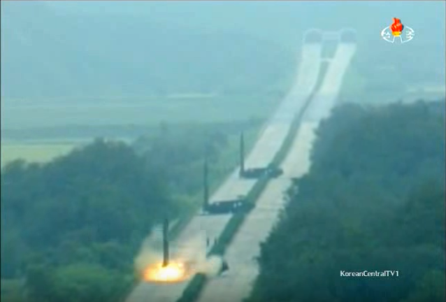
I'd like to quickly touch on the missile tests. According to CNN, the tests were carried out in Hwangju County, North Hwanghae Province (25 miles south of Pyongyang center). Korean Central Television released a YouTube video of the missiles being fired. In the video, you can see that the missiles were fired from mobile launchers positioned on a major highway with a highway tunnel in the background. In another scene a cell or radio tower is also visible.


Given the positioning of the camera, it's difficult to really gauge how far away the tunnel is from the launchers, however you can see a "turn around" spot near the tunnel and a bit farther back toward the launchers, you can see a section of pavement that looks a bit darker than the rest. This is typical of bridges. There's only one highway section that features all of these things near Hwangju.


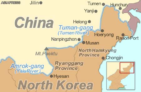
So, this stretch of highway would seem to be the most likely location of the tests. Hwangju is also the home of the Third Air Combat Command which is responsible for the defense of the DMZ and southern portions of the country, which means they would have access to ballistic missiles. Additionally (whether or not these missiles came from here), the hills around Hwangju are filled with tunnels, hardened artillery sites, military units, and military storage facilities. That said, I cant't find any section of highway in the entire province that seems to look exactly like the video footage.

Mapping Update

As I mentioned in the Phase I release post, Phase II (which I'm working on now) will include a map of all the schools, town halls, "Palace's of Culture" (Juche study halls), and other buildings of interest in the country. I started mapping these places part-way into Phase I, meaning that I had to go over the rest of the country another time to get all the sites I hadn't originally marked.

The blue dots cover all the areas I have had to re-map (which adds up to roughly half of the country). In addition, I decided to go over Pyongyang entirely for a second time because of how dense the city is. My goal in all of this is to not miss greater than 10% of any given type of item (cell towers, schools etc) nationwide.


The Google Earth file size for Phase I is 2.7 MB and contains over 28,000 places. The current Phase II file adds a further megabyte, and I'm not even finished working on it! The file for Pyongyang itself has nearly doubled in size.

To help make the project of greater use to people, I have been scouring different sources for additional information on the various sites I've marked. If the name of a school is known, I want that placemark to be given the school's name. If a fancy looking new building pops up, I want to be able to tell you what it is, and so forth. Since I began this project over 3 years ago, I have also gone back through some of the folders and updated them, better categorized some places (particularly military sites), and worked to make everything uniform in terms of descriptions and the icons used.

The work for Phase II really comprises two parts: the first part is all the new mapping I'm doing, the second part is taking Curtis Melvin's North Korea Uncovered file (which is now over 7 years old) and updating any changes that have happened to the 8,100 sites he mapped. This also includes making corrections to places that were incorrectly identified (there aren't many, but accuracy is important) as well as fixing a problem created by Google Earth itself.

When Google Earth has updated imagery added, sometimes the coordinates don't mesh perfectly and, particularly in South Hwanghae Province, around 2006 the coordinate system was adjusted. The practical meaning is that many of the places marked there by Curtis are now off by as much as 1,000 feet. So I need to go through all of them and move them to their "corrected" positions. Oh, and I have to do the same for the large military-focused file created by Google Earth user "Planeman_"  and then collate his and Melvin's files because each project, while largely covering the same places, did map out some spots the other person missed. All of this adds up to a mountain of work.

The work of Phase I was completed in Nov. 2015 and released in March 2016. Since then, I have been able to go over nearly all the places I needed to. I only have about 20% of Pyongyang left. I have also already gone through thousands of sites marked by Melvin and Planeman_, though there is still much work remaining on that front. Some of the cool things that my comprehensive map will be able to bring to the general public is: 24 surface-to-air missile sites previously un-mapped by the earlier projects, the entire network of cell towers (very few existed during the time Melvin was working on his project), an updated map of their missile testing sites, more detailed maps of various palaces, a much more detailed map of Pyongyang with hundreds of buildings marked, and lots of added bits of information on countless other sites (including nuclear facilities).

I have a two week international vacation coming up soon and then of course the holidays are getting closer and closer, but I am really hoping to be able to have my Phase II mapping completed, the corrections/updates made to North Korea Uncovered, and the combining of Phase II, NKU, and Planeman_'s projects into a single master file with no duplicates and as few holes as possible by the end of 2016, if not sooner.

I'd like to thank everyone for their continuing support and patience. This has turned into a major project that has required thousands of hours of work and research. I hope it will be useful and live up to expectations once completed.

--Jacob Bogle, 9/7/2016
www.JacobBogle.com
Facebook.com/JacobBogle
Twitter.com/JacobBogle