Friday, September 15, 2023

Pyongyang: COVID Fortress

AccessDPRK has been at the forefront of using satellite imagery to uncover North Korea's anti-pandemic measures. It was the first to use satellite imagery to verify reports of the "border blockade", it was the first to offer a nationwide look at those border changes via the AccessDPRK map, and it was the first to expose a network of covert COVID isolation facilities that was built across the country.

Screenshot of KCTV program (July 27, 2020) showing a COVID disinfection checkpoint along the Pyongyang-Kaesong Highway. Image source: NK News.

North Korea has used the pandemic to clamp down on human movement and trade in the most extreme ways, and it has relied on myths and pseudoscience to back up its policies. From claiming that COVID could pass into the country from Chinese dust to putting people in quarantine for coming into contact with objects from South Korea - despite there being very little evidence that one can contract the virus by simply touching an object - North Korea's anti-pandemic measures have caused an inordinate amount of harm.

Of course, given the state of the country's healthcare system, any pandemic could pose an existential threat to the state (to say nothing of the people living there). That is why it's little surprise to discover that authorities embarked on building not just border and coastal fences but have tried to erect an anti-COVID barrier around Pyongyang itself. 


First, however, I want to review the other infrastructure changes that North Korea has instituted in its fight against COVID.

North Korea was the first country to completely close their borders in response to the COVID-19 pandemic. To accomplish this, not only were all border crossings closed and trade & tourism suspended, but authorities erected hundreds of kilometers of new border fence (often in two layers) as well as repaired and modernized the existing border fences.

Map showing all border and coastal fencing as well as fences along the DMZ.

As part of the border closure, they added over 15,000 additional guard posts and garrisons along the border with China and Russia. They also improved security along both coastlines. AccessDPRK has verified the existence of 2,008 km of northern border fence and 1,567 km of coastal fence that now ring the country (plus hundreds of kilometers of DMZ fences). 

Within the country, numerous checkpoints were set up to further limit human movement and the spread of the disease. Some of these are simple tent-like structures where a person's temperature can be taken, and others are existing vehicle inspection points that have been expanded to allow for decontamination processes.

At the border crossings, most have simply remained shuttered. But at Sinuiju (the main crossing with China) and Tumanggang (the only crossing with Russia), new facilities to quarantine and disinfect goods and people were set up to handle what little trade has occurred since 2020, and to prepare for when trade is normalized again. There is also evidence of disinfection infrastructure being built at the ports of Nampo and Tanchon.

Location of all identified COVID isolation facilities. 

And as part of actually providing a level of medical care, albeit a questionable level, dozens of suspected COVID isolation facilities (95 at last count) have been constructed throughout the provinces. These highly secured compounds can isolate patients who test positive with COVID or have a severe "unidentified" fever, while not taking up additional room in the country's poorly staffed and supplied hospitals. Within Pyongyang, the city's hospitals have all had dedicated COVID wards set up.

It is within this context that I want to detail the latest apparent COVID infrastructure project: fencing off Pyongyang itself.

Map showing the location of the capital COVID fence. The yellow lines represent confirmed fence paths. The white lines represent rows of guard posts that may or may not be connected by fencing.

Because there are gaps in the available image data from Google Earth, I haven't been able to map out the full system as it exists today, but I have been able to locate enough of it to provide this review.

Beginning no earlier than March 2020, the construction of a series of fences, guard posts, garrisons, and checkpoints began. In parts of the city, the first iteration of the system was already built by October 2020, while in other areas construction extended until at least June 2022. 

Detailed look at the fence with a garrison building and guard posts visible.

Another detailed view of the fence. The fence's path is clear as are the guard posts and foot patrol path.

Based upon the available imagery, there are at least 63.2 km of clearly identifiable fencing with a further 22.9 km of rows of guard posts that may or may not also be connected by fencing. The guard posts are typically spaced every 75-100 meters. With 86.1 km of fenced and unfenced guard post lines, that means that roughly 1,000 guard posts (between 861 and 1,148) have been constructed around the city. 

Locations of garrison (barracks) buildings.

Just like with the country's border fence, these posts are supported by a network of at least 28 purpose-built garrisons (barracks) - six of which were actively under construction in June 2022. There are several other sites that I believe are now being used as garrisons, but they were previously used for other purposes. I haven't included them on the map because of a level of uncertainty. 

Locations of identified checkpoints, both pre-existing ones and newly constructed.

The fence system is also interconnected with the capital's checkpoint network and consists of 35 checkpoints of various types. Of those, twenty were built since 2020 and several of the preexisting sites have had visible upgrades. 

Explanation of gaps in the fence system. "Image gaps" refers to a lack of more recent imagery available on Google Earth.

There are parts of the terrain around Pyongyang where I have not been able to identify any new fencing. However, some of these areas are already "protected" by existing fences from factories or agricultural places, and those fences have been incorporated into the new system. Additionally, large sections of eastern Pyongyang are afforded security by the wide Taedong River (which serves a natural physical barrier), and northern sections of the city are mountainous and filled with military bases - effectively creating large swathes of inherently restricted territory. 


Thus, Pyongyang now sits at the center of a multilayered security network; a city that already required permits to visit, can now shut itself off from the rest of the country at-will. This doesn't only include restricting traffic from the main roads (an ability that has always existed), but even prevents Pyongyang farmers from coming too close to the city core by merely crossing a field on foot. 

The Central Quarantine Command oversees Pyongyang's anti-pandemic measures, instituting lockdowns, and enforcing the various government orders relating to the pandemic. However, whether or not this capital fence system is subordinate to the CQD, is part of the capital police force, or is part of a multi-agency force isn't yet known. 

I reached out to several North Korea experts including those with access to information from within the country, and only hints of information about this fence have begun to make it to outside researchers - and there had been no independent verification of it until now. It seems that North Korean authorities have been keen on keeping it a secret. 

However, as defector and former Pyongyang resident Hyun Seung Lee told me, it is "highly possible [that such a fence was constructed] since the country's top priority is Kim Jong Un's health. If anything COVID-19 related happened inside North Korea, none of the authorities will be free from responsibilities to protect the leader."

Considering the large number of checkpoints that already restricted access to Pyongyang, it may seem redundant to build dozens of kilometers of fences and a thousand guard posts to further cut off the city. Yet, North Korea not only built over 15,000 additional guard posts to seal off their northern border they also built fences all along the coastline. And so, North Korea seems to fight viruses with the same tactics as they would an invading army - block the enemy from being able to move. In this case, the general population plays the role of "enemy".

Although North Korea appears to be preparing to reopen its borders, it's clear that they have invested in the physical infrastructure needed to reenter lockdown at any time, and to continue to further restrict human movement within the country. This latest discovery underscores the paranoid nature of the state and demonstrates how Kim Jong Un would rather resort to force (sealing off the capital and placing thousands of guards on patrol) than take helpful steps like granting general access to vaccines or allowing adequate humanitarian aid into the country. 


I would like to thank my current Patreon supporters who help make all of this possible: Alex Kleinman, Amanda Oh, Donald Pierce, Dylan D, Joe Bishop-Henchman, Jonathan J, Joel Parish, John Pike, Kbechs87, Nate Odenkirk, Russ Johnson, and Squadfan.

--Jacob Bogle, 9/15/2023

Saturday, August 26, 2023

Building North Korea's Bomb

If you've ever looked at a diagram of a nuclear bomb (whether of Little Boy or of a modern miniaturized warhead like the W-87), you might be forgiven for thinking constructing such devices looks fairly straightforward.

For a gun-type fission weapon (like Little Boy), you simply fire a hollow chunk of uranium at a solid cylinder slug of uranium, setting off a chain reaction. For a simple implosion-type weapon, you just wrap a core of plutonium in a shell of conventional explosives and detonate it. That will create an implosion shockwave, compacting the plutonium until it reaches criticality and explodes with the force of thousands of tons of TNT. 

Even today's advanced two-stage thermonuclear weapons can be rendered in handy graphics. But the simplicity of popular descriptions of how nuclear bombs work belies their devilish complexity.

Diagram of the W-87 two-stage thermonuclear warhead used by the United States. Image: US News & World Report.

All of these descriptions and diagrams are simply distillations of feats of physics and engineering that took thousands of people and billions of dollars to produce in each of the countries that have developed their own weapons.

The world's nuclear weapons programs rely on physicists, engineers, often some of the most powerful supercomputers in history, and networks of manufacturing centers that are responsible for safely producing the uranium and plutonium needed as well as the scores of individual components that make up a working nuclear device.

In the United States, the primary assembly of nuclear warheads takes place at a single location in Texas. But that's just the final step in a long chain of research and production that involves facilities across the country, from the mountains of Tennessee to the deserts of New Mexico.

Likewise, North Korea's nuclear weapons program is a decentralized affair that includes mining sites surprisingly close to the DMZ to top secret underground storage facilities just a couple hours away from the border with China. 

In this article, I will attempt (with a caveat) to layout North Korea's nuclear weapons infrastructure. 

That caveat is: no country makes its nuclear secrets easy to uncover. Building a nuclear weapon takes the combined efforts of thousands of people, and uncovering the exact design components and in which factory which part is made is typically highly classified information. Because of that, this can't be a comprehensive exposé. There is still plenty about Pyongyang's nuclear program that isn't publicly known, and plenty that isn't even known to government intelligence agencies.

However, there is enough known information to provide a solid outline of many of the facilities North Korea uses to produce their nuclear arsenal.

With that in mind, let's get to it.


Kim Jong-un National Defense University.

The first steps to building a bomb are in research and development. For North Korea, this takes place at several institutions including the Atomic Energy Department of Kim Il-sung University (39.059259° 125.767729°), the Physics Department of Kim Jong-un National Defense University (39.169623° 125.776838°), as well as three departments within the Pyongsong College of Science (the Chemical Department, Physics Research Institute, and Atomic Energy Research Center). Additional research also takes place at some of the locations I'll discuss in greater detail below.

Once you have the theories and designs worked out, you need some raw materials.

North Korea has modest uranium deposits and has mined it from locations across the country including at the Wolbisan Mine and at mines near Sonbong. However, North Korea's primary uranium mine is located in Pyongsan (38.323984° 126.436512°).

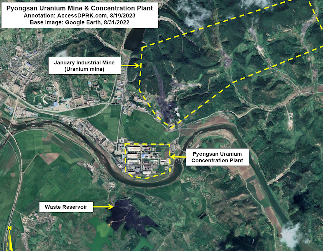
Pyongsan uranium mine and concentration plant. 

The Pyongsan uranium mine (also called the January Industrial Mine) is an anthracite coal mine that contains usable concentrations of uranium as an impurity. The mine has five mining shafts with one, possibly two, currently active. 

From the mine, the ore is taken via a conveyor system about 500-meters-long to the uranium concentration plant and mill.

The people over at Arms Control Wonk and the Center for Strategic and International Studies have written in-depth reports on the history and workings of the Pyongsan Uranium Concentration Plant. But here's a brief rundown.

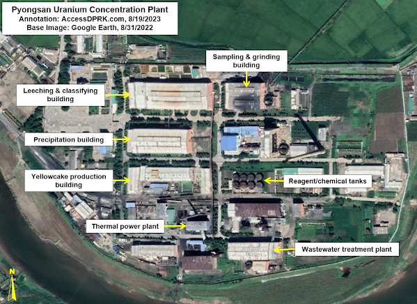
Pyongsan Uranium Concentration Plant.

Construction on the plant began in 1985 and it was operational by 1990, albeit on a limited scale. Full-scale production wasn't reached until ca. 1995.

The ore is brought to Pyongsan where it is processed to separate out the uranium from the rest of the minerals found in the coal source material.

The uranium is found in reported concentrations of between 0.26% and 0.8%, and at least 10,000 tonnes of ore are mined each year; although, this estimate varies widely and annual production levels also vary year-to-year. This is then processed and concentrated into what's commonly known as yellowcake, which is 80% pure uranium. 

The uranium extraction process involves (simplistically): crushing the coal, sampling, grinding it down into a powder, adding sulfuric acid and sodium chlorate to leech out the uranium, washing it, running it through an extraction circuit and salt solution, and passing it through precipitation tanks where the concentrated uranium can be gathered, and dried. The yellowcake is then packed and shipped off for enrichment.

After processing, as much as 272 tonnes of yellowcake uranium leaves the plant annually in the form of triuranium octoxide (U3O8) and uranium dioxide (UO2). 

North Korea does have a second uranium concentration plant at Pakchon (39.710533° 125.568319°). It began operations in 1979 as a pilot plant, but has been in caretaker status since at least 2002, with only low-level activities noted from time to time, leaving Pyongsan as the only active uranium mill.  

From Pyongsan, the uranium needs to be enriched. There is only one verified enrichment facility, at Yongbyon. There is a suspected site near Pyongyang at Kangson (38.957195° 125.612159°), but there is considerable debate within published sources about Kangson's purpose.


Other raw materials besides uranium are needed to support the country's nuclear program (from graphite to tungsten), but which mines exactly are used isn't known. However, there are several identified mines that could provide North Korea with some of the needed materials. 

There are several specialty materials and components associated with uranium enrichment and modern warhead manufacturing that North Korea is not known to have the capabilities to produce domestically, but the country clearly has enough legacy technology and skill to overcome those shortcomings and to produce these deadly weapons. 


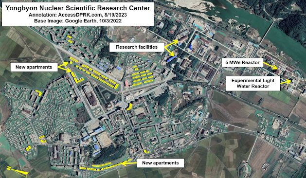
The Yongbyon Nuclear Scientific Research Center (39.796977° 125.755110°) is North Korea's key nuclear facility. With a history dating back to 1963-64, Yongbyon plays a central role the country's development of nuclear weapons.

Yongbyon Nuclear Scientific Research Center.

Located some 85 km north of Pyongyang, the complex covers a 24.8 sq. km. area that's surrounded by fences and guard posts. Within Yongbyon lies the town of Dong-an (formerly Sang-dong) which serves as the civilian quarter and houses all the scientists, researchers, technicians, their families, and everyone else needed to run the town and research centers. 

Southeast of the town is a walled compound containing the research center's administration, laboratories, and various other facilities. South of that, is an adjacent walled compound that houses the 5MWe nuclear reactor and the Experimental Light Water Reactor, as well as the spent fuel storage building. 

Elsewhere in Yongbyon is the Radiochemistry Laboratory (39.781174° 125.753286°) where plutonium is produced as well as radionuclides used in nuclear medicine. And then there is the uranium fuel fabrication facility (39.770255° 125.749224°) where the uranium brought in from Pyongsan is further processed and enriched into weapons-grade material. The fuel fabrication facility is also used to manufacture the fuel rods needed for the nuclear reactors.

The uranium complex at Yongbyon, including the enrichment halls.

Estimates place Yongbyon's annual capacity to be 100 kg of highly enriched uranium and 6 kg of plutonium. The enrichment hall at the uranium fuel facility was enlarged in 2013 and again in 2021, indicating an increase in North Korea's enrichment activities.

According to the Center for Arms Control and Non-Proliferation, North Korea has enough fissile material to build a further 45-55 nuclear warheads. 

Another change of note within Yongbyon has been the construction over the last decade of enough housing for ~3,200 new residents. The increase in Yongbyon personnel, the enlargement of the uranium fuel fabrication facility, and other changes in recent years (at Yongbyon and elsewhere) have enabled Kim Jong-un to ramp up the production of nuclear warheads.

This increase in capacity was reflected in a 2022 speech by Kim Jong-un in which he vowed to "exponentially increase" the size of the country's nuclear arsenal. 

However, simply having a pile of enriched uranium and plutonium doesn't a nuclear bomb make.


Yongdoktong nuclear complex.

Nuclear weapons use shaped charges made of conventional explosives as an "explosive lens" to collapse the inner shells within the device and lastly to compress the core of fissile material, initiating the chain reaction.

Yongdoktong (40.004320° 125.339377°), just east of Kusong, is where these lenses are developed, tested, and manufactured. 

A review of Landsat images reveals that construction of the complex began ca. 1987 with most of the work completed by 1992. In more recent years, several changes have been noted including at least 18 new buildings or building renovations since 2016, the addition of greenhouse and garden facilities in 2019, and ~47 new housing units, most of which were built since 2020. On top of that, in late 2020, a new building was constructed to cover the entrance to an underground facility near the main production center.

Explosive lenses are often produced at or near the same facility that conducts the final assembly of warheads. The size of Yongdoktong, its several distinct sections and underground sites - to me - makes it a candidate location for where North Korea builds their completed nuclear warheads.

Additionally, it is where intelligence sources suggest that North Korea stores its warheads in underground facilities within the complex. 

Regardless, warheads may then be taken from Yongdoktong to Punggye-ri for underground nuclear testing or they could be sent to one of a dozen or so ballistic missile bases.


Punggye-ri nuclear testing complex.

Punggye-ri (41.279084° 129.087133°) is North Korea's only nuclear test site. The facility runs south from Mount Mantap and down a valley for ~17 km. At the foot of Mount Mantap, four tunnels for underground nuclear testing were dug. From there, a series of administrative, support, and guard buildings are situated along the valley.

The exact year that Punggye-ri was established is difficult to ascertain but excavation work on the testing tunnels began in the early 2000s, and the site was being monitored by South Korean intelligence agencies as early as the 1990s.

To-date, six underground nuclear tests have been conducted, but only three of the four tunnels have ever been used. The first test took place in 2006 and the most recent (and most powerful) nuclear test occurred on Sept. 3, 2017. After that, North Korea announced that they had successfully completed the tests required to prove the validity of their nuclear weapons designs, and that Punggye-ri would be shuttered. 

On May 24, 2018, in front of foreign media who were especially invited to attend, the tunnel entrances were ceremonially blown up. However, doubts of Punggye-ri's closure were raised almost immediately. In the coming months and years, satellite evidence revealed that the facility had only been placed in caretaker status and remained suitable for future tests.

In 2022, new construction activity at the site was identified and U.S. officials later announced that the facility had been repaired and that further nuclear tests could take place at any time.

Validating the design of new warheads through testing is an important step in developing a credible nuclear force, particularly as North Korea advanced from testing crude nuclear devices (as in 2006) to developing miniaturized thermonuclear devices that could be mounted onto missiles. 

It is likely that further testing will be required as North Korea refines its designs and develops new variants. Currently, it is generally accepted that North Korea now possess ~30 operational nuclear warheads and is actively building more.


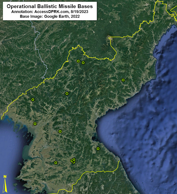
Map of known operational ballistic missile bases.

Ballistic missiles require adequate device miniaturization and heat shielding to deliver a functional warhead to the target. U.S. intelligence assessments concluded that North Korea had developed the capability to miniaturize a nuclear device and mount it onto a ballistic missile by 2017.

However, there is still debate whether or not Pyongyang has yet developed the capability to manufacture the necessary heat shielding for the reentry vehicles that are used in hypersonic missiles and MIRVs (multiple independently targetable reentry vehicles) that North Korea's seeking to acquire.

The country has around a dozen operational ballistic missile bases and a further dozen or so support facilities (for equipment storage, training, etc.). These bases are roughly divided into three "belts" around the country, with medium-to-intermediate range ballistic missiles and intercontinental ballistic missiles being deployed at bases in the "operational" and "strategic" belts (in the center and northern parts of the country respectively), and short-range missiles deployed in the "tactical" belt close to the DMZ. 

There are questions whether or not any warheads are actually stored at these missile bases, ready to be launched, or if they are all held at Yongdoktong and would only be moved to missile bases following a direct order from Kim Jong-un. 

Keeping them at Yongdoktong would introduce a serious delay in North Korea's ability to rapidly launch a nuclear-armed missile as the warheads would have to be transported from there to the bases. (The nearest operational base to Yongdoktong is over 50 km away by road.)

But for now, any discussions about deployed warheads or North Korea's nuclear command and control remains largely speculative.

What isn't speculative is that North Korea has worked for decades to develop the technology and infrastructure needed to build a nuclear arsenal, despite international condemnation and despite the tremendous hardships the nuclear program has caused the people of North Korea. 

And although I was able to highlight several publicly known nuclear facilities in this article, North Korea is known to have other undeclared research and industrial centers that play a role in the country's nuclear weapons program. Having a detailed accounting of these sites will be imperative to any successful denuclearization or arms limitations agreement in the future.


I would like to thank my current Patreon supporters who help make all of this possible: Alex Kleinman, Amanda Oh, Donald Pierce, Dylan D, Joe Bishop-Henchman, Jonathan J, Joel Parish, John Pike, JuneBug, Kbechs87, Nate Odenkirk, Russ Johnson, and Squadfan.

--Jacob Bogle, 8/26/2023

Monday, July 24, 2023

Kim Jong Un's Underground Pyongyang

Verifying the existence of underground facilities can be a difficult task, especially when their existence is a state secret. But rumors eventually come out and tantalizing hints of their presence can sometimes be found.

For North Korea, these rumors tell of secret subway lines beneath Pyongyang and underground highways connecting major palaces, maybe even reaching as far north as the border with China. I have written quite a lot about North Korea's underground infrastructure, but direct evidence and declassified sources still remain scarce. 

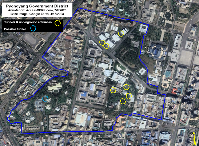
Overview of the Pyongyang Government District.

However, within the secured government district of Pyongyang are signs of multiple tunnels and underground structures. While it's impossible to know how they all connect to one another or even if they do, their locations and prevalence do hint at a fairly robust underground network that supports the infrastructure, transportation, and security needs of Pyongyang's most important district.

The easiest way to identify underground facilities is to either spot their entrances or actually catch them being constructed. For the secured government district, most of the buildings were constructed decades ago, placing their secrets out of reach for those without security clearances. But under Kim Jong Un, there have been some substantial changes to the district and that has given North Korea watchers an opportunity to see observe some of them.

There are two main sets of tunnels within the 138-hectare district that are visible to satellite. The first is a set of four tunnels near the Central Committee Office building (also known as Kim Jong Un's office) and the adjacent villa (Residence No. 15). The second is a set of four tunnels leading to underground parking garages beneath three buildings that were constructed in 2018-2019.  

There is also a possible tunnel, marked in light blue, but I can't fully verify that it is a tunnel. In some images, however, it appears that there may be a road tunnel that dives under a gate near Kim Kyong-hui Hall, just south of Changgwangsan House.

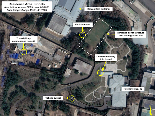
But the tunnels around Kim Jong Un's office and Residence No. 15 are quite clear.

April 10, 2020 image of the four tunnels around the Central Committee Building (Kim's office) and his district villa, Residence No. 15.

Apart from the tunnels by the villa and office, which I'll detail next, there is also a smaller tunnel in the maintenance complex. This complex handles building heating and cooling equipment, provides maintenance services, and may also play a role in electricity and water supply to the adjacent buildings. The tunnel (39.016557° 125.743544°) is 5-6 meters wide and runs toward the southwest. It's visible on all satellite imagery going back to 2000.

The tunnel may simply lead to a hardened bunker housing additional equipment or it could actually connect into the Office 39 complex (which includes the Kim Il Sung Revolutionary History Institute [39.016134° 125.741890°] and other Party buildings). Given its size and location, I do not think this tunnel plays any special security role. Rather, it's most likely just an access tunnel for providing building services.


April 1, 2023 image showing changes since 2020.

In 2022 a villa was rebuilt and enlarged, and in late 2022 a new hardened structure was built over the site of the tunnel nearest Kim's office building. 

The 'office tunnel' is large enough for vehicles and may lead to an underground garage or a larger underground complex. The hardened structure above it is approximately 60 by 30 meters in size and rises approximately 3 meters above the surrounding gardens.

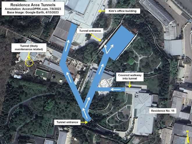
Conjectured tunnel layout.

Due to the number of visible entrances, a concept of the tunnel layout can be formed with some confidence despite not having all the information. 

The covered walkway from Residence No. 15 was constructed in 2010. It resembles another such walkway that was built in 2017 in the armed forces district 5 km north at 39.062677° 125.740196°. 

The southern tunnel entrance was also constructed ca. 2010-11. Following the path drawn in the above image, the southern tunnel is about ~150 meters from the northern tunnel at the Central Committee Office Building (CCOB). 

The northern tunnel, however, was only constructed in 2018. This means that the southern tunnel likely went directly to the CCOB, where an alleged 60-car garage also exists beneath the assembly hall. 
This connection allows people from Residence No. 15 to travel on foot or by car directly and safely to the CCOB. Then, in 2018, a new tunnel was built from the CCOB that would link up with the southern tunnel.

This construction also included the building of an underground structure which was later (2022) replaced by the 60 x 30-meter hardened structure now seen in satellite images. Allegedly, a small, electrified rail car is also employed within the tunnels, but I haven't seen any supporting evidence of that.

To the north of the Central Committee Office Building, between 2018 and 2020 four currently unidentified buildings were constructed. These buildings include glass-covered entrances to underground parking garages that, most likely, would also double as bomb shelters in the event of an air attack.

Underground garage entrances under construction in June 2020.

The underground garage entrances after completion are covered by glass canopies.


There are also reports (including from Hwang Jang-yop) that the Pyongyang Metro has a secret line for government use that connects important government and military installations around the capital, and that it even reaches as far as Nampo and Sunchon (50 km away). While this has never been independently verified, the government district does lie within 2 km of four subway stations, with the closest being Pongwa Station at only 600 meters away from Kim's office.

As most of the district was constructed in the 1960s and 1970s (as was the metro), underground entrances to the metro system could be hidden beneath key administrative buildings, beyond the prying eye of today's satellite fleet. I have doubts about a sprawling network of transportation tunnels connecting far flung facilities, but a local network connecting underground command centers and emergency escape routes is quite plausible. 

Location of other known tunnels and underground facilities (UGF).

Whether underground sites exist in isolation or connect to larger tunnel networks beneath the government district and beyond, the sheer number of bomb shelters and other underground facilities alleged to exist makes the possibility of a successful "decapitation strike" by South Korea or the United States far more difficult and less likely to be effective, as such an attack relies on knowing where the target individuals are and killing them before they have time to escape to another location.

While I can't comment as to the quality of their construction, as a regime hyper-focused on survivability, North Korea probably has the greatest density of underground facilities and secret tunnels of any country on earth. 


I would like to thank my current Patreon supporters who help make all of this possible: Alex Kleinman, Amanda Oh, Donald Pierce, Dylan D, Joe Bishop-Henchman, Jonathan J, Joel Parish, John Pike, JuneBug, Kbechs87, Nate Odenkirk, Russ Johnson, and Squadfan.

--Jacob Bogle, July 24, 2023

Tuesday, June 20, 2023

Bye, Bye Airports

Ever since Kim Jong Un came to power, North Korea's aviation infrastructure has undergone a series of changes, making it difficult to keep an up-to-date record of what airports and landing strips exist and where.

For this article, I want to review more recent changes and provide an update to the last AccessDPRK post that focused on the country's air force back in 2018.

KCNA photograph of Kim Jong Un inspecting aircraft at Kalma International Airport. 

Starting in 2014 Kim constructed several small new runways at his favorite palaces, then he went about improving the country's emergency landing strips. Before that, he oversaw the modernization of Pyongyang International Airport and then majorly expanded the Kalma Airport in Wonsan.

In recent years, however, the trend has reversed. Eight airports have been razed and another converted to other uses (at least for the time being).


Before and after of the Sinchon Palace runway (38.350777° 125.535155°).

Two of the palace runways were removed and replaced with horse riding tracks - Sinchon Palace Runway (built in 2015, replaced in 2019) and Wonsan Palace Runway (built in 2014, replaced in 2019). These horse riding tracks are for Kim Jong Un and his closest allies to use, but a number of recreational and military horse tracks have also been established elsewhere around the country. 

Before and after of the Wonsan Palace runway (39.184090° 127.397012°).

A third palace runway, at Myohyangsan (40.028515° 126.193115°), was demolished in 2021.


The Pyongyang VIP Heliport (39.049587° 125.805278°), built in 2015, is also now being removed and a new complex of buildings is being constructed in its place. The full purpose of the building complex isn't yet known.


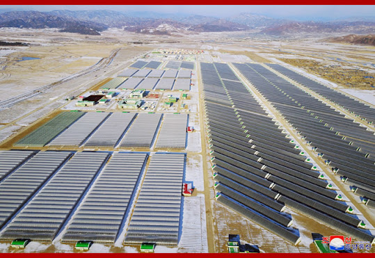
Ariel photograph of the Jungphyong (Kyongsong) Vegetable Farm. Image: Rodong Sinmun, 2019.

Then there are the two airbases that have been demolished and replaced with large vegetable farms and greenhouses - Kyongsong Airbase (41.558215° 129.629752°) was demolished in 2018 and the Yonpo Airbase (39.790289° 127.535685°) was demolished in 2022. This has been the largest transfer of military property to the civilian sector that I am aware of, affecting slightly over 5 sq. km. 

Although the Kyongsong Airbase was demolished for the vegetable farm (named Jungphyong after a nearby village), the associated air force officer training school still exists (41.577780° 129.634636°). 


Overview of the Uiju Decontamination Facility (40.152699° 124.499932°).

COVID-19 has also impacted the availability of airbases to the North Korean air force. The Uiju Airbase, near Sinuiju on the border with China, was shut down in 2021 and some of its aircraft transferred to other sites. Then Uiju was fenced off and turned into a massive decontamination facility for goods coming into the country from China. 

Unlike Kyongsong and Yonpo, the runway and other facilities at Uiju still remain and it could be reconverted into an active airbase at any time. 


Kumgang, a county in Kangwon Province and where the Mount Kumgang Tourist Region is located, only had a small dirt runway that was routinely damaged by floods. In 2011-2012, to the north of town, a new kilometer-long paved runway was constructed, complete with aircraft parking revetments, service buildings, fuel storage, and hardened bunkers. It also goes by the name of Onjongdong-ni Airfield. 

Yet, in the imagery available, there's no clear evidence that the runway was ever used and the runway itself deteriorated over the years due to flooding. In 2021 several of the bunkers were demolished and the above-ground fuel tanks were removed. However, the runway's fate had already been sealed much earlier.

In 2018 the construction of a dam 1.7 km to the south began. The runway will eventually be covered by the reservoir once the dam's completed.  


Last of the removals, the small Kangdong Airbase (39.158318° 126.039708°) was demolished in 2019/2020 after being remodeled in 2015. It was home to KPAF Unit 2620, an all-female pilot unit. 


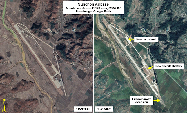
Sunchon Airbase underwent a recent expansion program.

In the midst of all of these removals, the Sunchon Airbase underwent an expansion beginning in 2021 and ending in 2023. The Center for Strategic and International Studies has tracked the progress of this project in detail (Part I, Part II, Part III), but it involved the addition of a 300-meter runway extension, the construction of 16 aircraft shelters, a new hardstand with space for 15 aircraft, and all surfaces have been repaved. 


With all of these changes, I think a current round-up of North Korea's aviation infrastructure is in order.

Excluding the now former airbases, there are 128 identified airports, landing strips, helipads, emergency runways, and UAV facilities. 

There are six primary airbases, 26 additional airbases with paved runways, 22 basic airfields (including grass landing strips), 30 emergency highway runways, 35 helicopter facilities, and seven UAV sites (which is a topic for another article). I also have the locations of 18 former and disused runways. That figure may change in the future as additional sites are discovered (such as demolished runways that existed during the Japanese occupation or Korean War).

With the exception of Uiju, no major airbases or runways have been affected by these changes. Practically speaking, only redundant airfields were demolished and whether or not Kim Jong Un has an on-site palace runway for his personal use makes little difference to the military.


I would like to thank my current Patreon supporters who help make all of this possible: Alex Kleinman, Amanda Oh, Donald Pierce, Dylan D, Jonathan J, Joel Parish, John Pike, JuneBug, Kbechs87, Russ Johnson, and Squadfan.

--Jacob Bogle, 6/19/2023

Friday, May 19, 2023

Tee-up, North Korea's Golf Courses

Pyongyang Golf Club in 2015, prior to expansion program. (CC BY-SA 2.0, Uri Tours)

It is often erroneously reported that North Korea only has a single golf course. In fact, the country has three, but none are open to the general public. In this article, I'll examine each one and their current status.

The golf course (39.107805° 125.997879°) at the unofficially-named Samsok Mansion, along the banks of the Taedong River east of Pyongyang, was recently in the news because North Korea tested its Hwasong-18 intercontinental ballistic missile on April 13 from a launch pad mere meters away. 

The launch site is located on an island within the mansion complex that was fitted out with berms and ponds (for an unknown reason) prior to the missile test. 

The golf course is the nation's smallest and was added to the mansion grounds in 1986. It consists of three holes with six sand traps which are arranged along a semicircular course running for 600 meters.

The mansion isn't one of the main residences for the Kim family, but it is surrounded by a dozen smaller villas set within a wooded landscape that are all interconnected by a network of private lanes. This suggests that the mansion serves as the center of a rural 'getaway' for the country's elite and provides a slower pace of life for those visiting.


Pyongyang Golf Club after 2017-2019 renovations.

The most well-known golf course, however, is the Pyongyang Golf Club (38.897281° 125.437426°). Located on the banks of Lake Taesong, this 18-hole course is part of a larger 16.4 sq. km. pleasure ground for the country's elite. Opened in 1987, it has been reserved for use by the country's wealthy and foreigners. 

In 2011 it began hosting the DPRK Amateur Golf Open, but there hasn't been a new tournament since 2016 despite attempts by several tourist groups to resume the competition.

Pyongyang Golf Club after most new construction had been completed in 2019.

However, that doesn't mean activities at the golf course have ceased. In 2018 plans were released by the government detailing an expansion of the Club. This included the addition of nine new holes, additional lodgings and other facilities.

Construction actually started as early as April 2017, with early landfill activities, but it began in earnest in 2018 and by February 2019 at least 13 buildings were nearing completion. Changes at the site also involved the creation of a small pond (by building a barrier to enclose a smaller portion of the lake) and the installation of a helipad which was finished by Nov. 2019.

Close-range ballistic missiles being launched on March 10, 2023 at Taesong Lake. Image: KCNA

Approximately 1 km north of the original club house is a peninsula that was meant to hold five of the nine new golf holes. Those have yet to be constructed but the peninsula did serve as the site of CRBM missile launches in March 2023. 


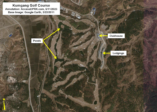
North Korea's third golf course was created as part of the Mount Kumgang Tourist Region (38.712675° 128.213664°) beginning in 2005. The course and grounds cover approximately 143 hectares and contains several lodgings/hotels, a clubhouse, and access to the floating Hotel Haegumgang.

The tourist region had been established as a joint DPRK-ROK venture, but the effort didn't last long.

The golf course in 2021 after years of neglect. 

Following the killing of a South Korean tourist in 2008, tourism from South Korea was halted. The North Korean government began to run domestic tours to the region in 2010 but these tours didn't generate much interest. 

For all intents and purposes, the golf course was shuttered soon after. Both sides have floated ideas to restart joint tourism, but nothing has come of these talks. 

In 2019 Kim Jong Un announced his intentions to rebuild and modernize the golf course and the whole tourist zone (regardless of South Korea's desires, as the area was largely financed by South Korea). This included the demolition of a hotel next to the golf course, the planned destruction of the Hotel Haegumgang, and other sites throughout the 530 sq. km. region.

As of late 2022, no new construction is visible, and the golf course has been allowed to decay. 


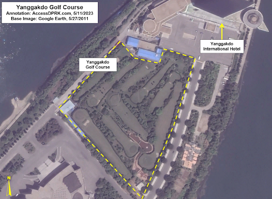
The former Yanggakdo Golf Course as seen in May 2011, a few months before its removal.

There had been a fourth golf course (38.997397° 125.750226°), one that was located on Yanggakdo Island in the middle of Pyongyang, next to the famous (or infamous) Yanggakdo International Hotel. But it was removed in late 2011 to make room for another hotel; however, that hotel still hasn't been completed.


I would like to thank my current Patreon supporters who help make all of this possible: Alex Kleinman, Amanda Oh, Donald Pierce, Dylan D, GreatPoppo, Jonathan J, Joel Parish, John Pike, JuneBug, Kbechs87, Russ Johnson, and Squadfan.
--Jacob Bogle, 5/18/2023

Monday, April 24, 2023

Construction at Huichon

Huichon is an industrial city in Chagang Province, North Korea that has been experiencing a construction boom over the last few years.

This latest round of work would likely not have occurred if it weren't for the completion of Huichon Hydroelectric Dam No. 2 - a project that was mired in complications and may have played a role in Kim Jong Il's death. The dam along with ten other hydroelectric generating stations built along the Chongchon River from ca. 2010-2019, have a combined generating capacity of 420,000 kW.

At the start of Dam No. 2's construction, approximately ninety multi-family housing buildings were also constructed in downtown Huichon that provided space for around 500 families. 

This current ongoing construction boom began in 2020. Some of the projects have been reported on by DPRK media such as in the Rodong Sinmun and in a television program titled "The Look of a New Town" which aired in July 2020. But others haven't been officially acknowledged yet. With that in mind, I'd like to highlight some examples that can be seen via satellite imagery. 


To start, there is a kilometer-long road tunnel (40.198067° 126.278119°) that connects two other projects I'll be discussing with the rest of Huichon and the Huichon Industrial Cooperative, which is a collection of factories near the center of the city. 

Satellite imagery reveals new spoils piles, suggesting that the interior of this tunnel is either being renovated or that the tunnel is being enlarged in some way.

The tunnel area as seen on October 2, 2020.

New work at the tunnel site as seen on Sept. 1, 2022.

Although the tunnel looks like a typical road and can be accessed from one of the city's main arteries, the road only leads to and from the Chilsong Electrical Appliance Factory. This feature becomes more interesting when you consider that the hill it runs through contains a warren of other tunnels, suggestive of a large underground facility (discussed further below).


Chilsong Electrical Appliances Factory as seen in 2018.

This tunnel leads directly to the Chilsong Electrical Appliance Factory (40.202665° 126.278621°) which is in the process of being completely rebuilt.

Little is publicly available about the specifics of the factory, but Kim Jong Il visited it in March 2010 and said that the factory was an important part of the country's economic future. However, that's the only leadership visit to the factory I can find in online sources. Regardless of the exact role of the factory, the fact it is being doubled in size attests to its continued importance. 

The factory is undergoing expansion. As seen in November 2022.

In 2018, the overall factory area covered approximately 12.5 hectares. In 2019/2020 the old factory was demolished and construction of a new factory campus began. This new area covers approximately 30 hectares and includes not only typical industrial buildings but will also have a stadium (somewhat common at large industrial sites), factory museum, revolutionary history/Juche museum, a health clinic for workers, and other amenities. 

The early stages of construction seem to have been carried out quickly, but it has since stalled. Little new activity is visible between October 2020 and December 2022. This may be a reflection of the COVID-19 pandemic's economic toll on the country.


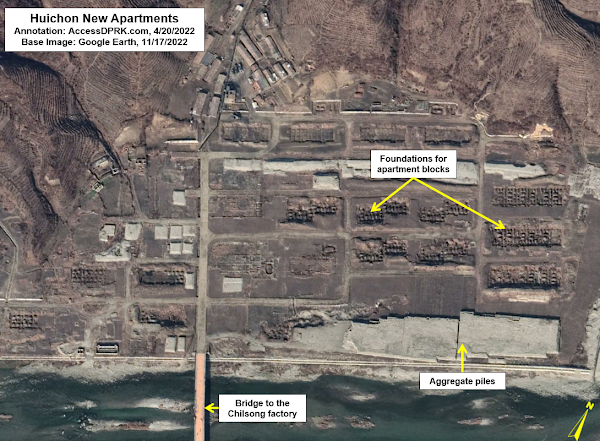
Foundations for new apartment blocks across from the Chilsong Factory.

Across from Chilsong (at 40.208419° 126.281558°) the foundations for 21 apartment buildings have also been constructed, perhaps as new worker housing for the expanded factory. Previously, only farmland and a few small houses existed on the site, but they were cleared away for the new apartments sometime between 2019 and 2020. However, like the stalled progress on the factory, only the foundations of the apartment buildings have been constructed, and the work appears relatively inactive as of Dec. 2022.


As mentioned earlier, the Chilsong factory is connected to the rest of Huichon via a tunnel. The hill the tunnel runs through has several other smaller tunnels that indicate the presence of a large underground facility (UGF) at 40.188214° 126.275511°.

The hillside is encircled by a newly built 3.5-km-long perimeter road (yellow) that can also be used to reach Chilsong and that connects to the six other tunnels (white) clustered at the southwest of the hill. There is no way to know how the tunnels are actually arranged or if there are large rooms within the hill, but I've created a speculative map of the interior tunnel arrangements based upon the location of each entrance and service adit.

There are three main entrance points to the hill. These are located together, and each entrance is protected by a small, covered structure. Previously, a series of greenhouses existed on the site as well but those have been demolished. 

Excluding the main road tunnel, if my estimated tunnel layout is considered, there are at least 3 kilometers of tunnels inside the hill.

After reviewing the available imagery, there isn't enough visual evidence to say if a factory complex exists underground or if the site is being used as a hardened storage facility. However, other "electrical appliance" factories are known to be involved in North Korea's armaments industry, and the closed-off nature of the underground facility and Chilsong factory raises further questions.


The Huichon COVID-19 isolation ward.

Within the new complex of the Chilsong Factory is one of over 80 (and counting) suspected COVID-19 isolation wards. Located in an out-of-the-way building (40.201310° 126.281072°) at the inactive construction site, the COVID ward was established in 2021. The 180-square-meter building is surrounded by a wall, has two guard posts, and all of that is surrounded by a perimeter fence. 

Public information is sparse about these facilities, but because of their high security and relatively small size, I surmise that they are used to isolate those who test positive for COVID-19 or have an otherwise unidentified fever until they either recover or need to be transported to a hospital that can provide intensive care (at least, North Korea's version of intensive care). 


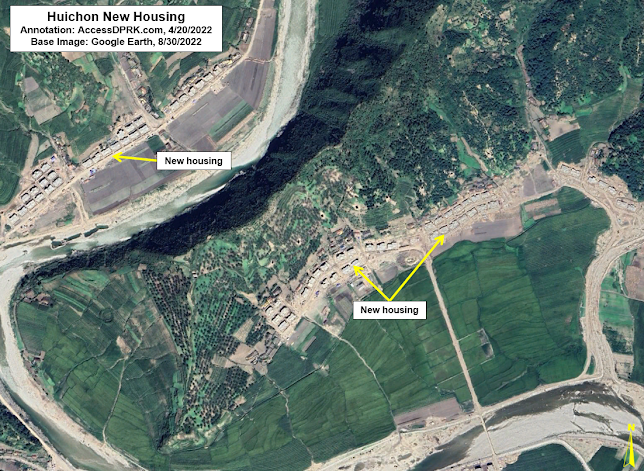
As part of the overall construction in the Huichon area, this school (40.205530° 126.244176°) and nearby housing have been reconstructed. The school will be 2-3 stories in height and there have been 14 new housing buildings constructed. Each building contains 2-4 individual housing units.

Across the river from the school a further 78 houses were built totaling 156 family units. The houses are in the new "countryside" architectural style promoted by Kim Jong Un in recent years.


The last construction project I want to discuss is the ongoing work at the Hagap Underground Facility (40.081244° 126.188535°).

Hagap is an underground complex 13-km south of Huichon that has an uncertain purpose. Construction began in 1991 but after several years of work it was apparently never completed. Following a prolonged period of inactivity, activity resumed in 2016. I have written about the progress at Hagap a couple of times (in 2017 and in 2019), and work is still ongoing.

Construction activity in 2016-2019 had been focused on improving access roads and building new tunnels, but since 2019 temporary worker's housing and workshops were constructed at the front of the complex, suggesting work is now being carried out in the interior of the main underground area.

As seen in the above image, construction work and landscaping have been completed at this auxiliary entrance site.

Secret nuclear facility, underground state archive, or something else, after 32 years of construction Hagap's purpose still isn't known. However, unlike the neglected underground facility at Kumchang-ni, North Korea seems intent on giving Hagap life and warrants continual monitoring.


I would like to thank my current Patreon supporters who help make all of this possible: Alex Kleinman, Amanda Oh, Donald Pierce, Dylan D, GreatPoppo, Jonathan J, Joel Parish, John Pike, JuneBug, Kbechs87, Russ Johnson, and Squadfan.
--Jacob Bogle, 4/23/2023