Wednesday, August 30, 2017

North Korea's Sacrificial Islands

When North Korea isn't firing intermediate and long-range intercontinental ballistic missiles (ICBMs) from highways and hidden factories, they're firing hellish amounts of smaller artillery. For the past several years, some of the recipients of these displays of military might have been two small islands off the coast of Wonsan.

The islands of So (So-do) and Hwangto (Hwangto-do) have been pummeled multiple times. Most recently in April and August 2017, December 2016, and March 2016. This video, originally from the Korean Central News Agency, discusses the August drills and shows images of the islands.

English-dubbed Video Source: StimmeKoreas

Both islands lie off the Kalma Peninsula, which is where the Kalma Airport is located (North Korea's recently modernized airport). Kalma is also the site of two rocket launch pads and has seen at least one failed rocket test.

So Island is approx. 6.7 km east of the tip of Kalma (among a small group of islands) and, farther south, Hwangto Island is 2.45 km east of the beach. At the tip of the peninsula are several villas, a sanitarium, and a possible hotel.

(Click on images for larger view)


Without further ado, here are the island martyrs.

So Island has a more recent history. Prior to 2014, the island appears to have served as a small outpost, perhaps for local fisherman. It contained a few buildings on the western side, and the rest was left alone. The buildings were demolished in late 2014.


So Island is a mere 460 meters by 293 meters at its widest points. As noted earlier, So Island was the target of an artillery drill in December 2016. The image below shows the results of that barrage.


This is a picture from the Korean Central News Agency showing the island being hit during the 2017 drill. The large island seen the background is Sin-do.

Image Source: TheSun.co.uk

Next is Hwangto Island, which has a longer history of being a bombardment target.


Hwangto is slightly larger than So at 587 meters by 295 meters. In the image below, shelling damage can be seen from a drill that occurred not too long before May 17, 2011. There is also a small building that has been demolished. 


On both islands, the structures seem to have been manually demolished rather than destroyed as a result of artillery. 


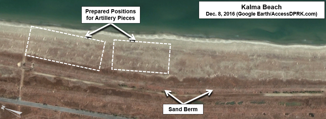
The above image shows the various prepared firing positions along the beach at Kalma. These sites are angled to line up with the the target on Hwangto Island.

In this KCTV picture from April 2017, the firepower displayed is rather impressive. An estimated 400 pieces of artillery were used.


The below image is the most recent on Google Earth. Dated Dec. 8, 2016, you can see the damage done from additional artillery drills as well as a new target. That target was used during the April 2017 drill.


Thanks to the support of OpenDPRK, I can now show you the results of this recent onslaught. 


The largest craters are 10-13 meters in diameter. 

These displays of might happen a few times each year and usually coincide with major holidays or as a response to US-ROK drills. 

I wonder how many more artillery drills it will take before the cliffs at So Island collapse?


--Jacob Bogle, 8/30/2017
JacobBogle.com
Facebook.com/JacobBogle
Twitter.com/JacobBogle

Friday, August 25, 2017

Kim Jong-un's Spy School Gets Upgrade

North Korean soldiers during an annual military parade.

One of North Korea's main espionage facilities, located in northern Pyongyang, is growing.

North Korea (with their several government agencies and branches of the military) has a long history of espionage and infiltrating South Korea. The DPRK also has one of the most active cyber warfare units in the world. Both the military and various agencies have a substantial amount of overlap.

According to defector Ahn Myung-jin, one of these facilities (which is near Kim Jong-il Political-Military Academy, also a spy school) is under the Strategic Division of the Central Party Espionage Department. The espionage training annex has a large underground facility with a tunnel 12 meters high, 30 meters wide, and 8 km long. It contains scale models of Seoul, important buildings like the Blue House, and even "functional" areas where officers can get used to going to shopping centers and using currency. The training period within the tunnel can last 15 days to a month each year.

As a reminder, clicking on the images will allow you to see larger versions.

This Google Earth image shows you the location of the espionage center (top) and surrounding points of interest.


Given its association with the Kim Jong-il Political-Military Academy, it is probable that this site is under the control of the General Reconnaissance Bureau, which is in turn controlled by the National Defense Commission (instead of the Korean Worker's Party which has its own intelligence agencies).


In this image from 2013, you can see the key areas of the center, including the underground tunnel entrance which also has an insert from another angle to allow you to see the actual opening. The two "areas of interest" are the main sites that will be changing.

On Nov. 9, 2015, commercial satellite imagery showed a building undergoing some type of alteration. The building had been emptied and the roof removed. It also shows that a collection of greenhouses near the main gate had been removed.


Fast forward to May 2016, and the first building mentioned above has been torn down to its foundations. A new building can be seen under construction as well.


The latest freely available commercial imagery is dated April 22, 2017. There is a lot of activity that can be seen.


The first buildings pointed out in earlier images are basically completed. However, there is new construction going on in two additional sites, plus a further building being torn down. The entrance gate is also undergoing some kind of an upgrade.

These changes will add at least 32,000 square feet (2,972 sq. m) of additional floor space. The site labeled "New Construction Site" is the location of an earlier building that has been demolished. If a new building is constructed and occupies the same footprint, that would modernize a further 39,000 sq. ft (3,623 m) of space.

To top it all off, the monuments are being changed, too. As I have written about extensively, monuments to the leaders (as part of the pervasive personality cult) are an integral piece of every military and civilian institution in the country.


The original monument was a group of 4 bronze figures, as seen above. The monument has existed since at least 2005. Sets of solar panels are also visible. These panels can first be seen in March 2016.

What is interesting is the lack of a central statue of Kim Il Sung (joined by statues of Kim Jong-il after his death in 2011). Nearly every major site in the country has such statues (to go along with murals and other smaller monuments).

It appears they've rectified this. On the April 22, 2017 image, the group of statues has been removed and now only spaces for two new ones are visible. This change also suggests, in my opinion, the elevation in importance of this complex.


In this image you can also see a close-up of some of the building construction going on. Near the statue place (which is on top of a mound) are piles of construction/landscape materials. The monument mound will be resurfaced with grass and other plants, the stone steps leading up to the statues themselves will be new, and it's likely the whole courtyard will be refaced with new stone.

The solar panels have been removed as well. It's probable they were only used to help power necessary construction equipment or needed lighting since a stable supply of electricity is still a problem, even in Pyongyang.

There are many examples of military locations being modernized, and various related construction projects are underway all over the country. While specifics are hard to come by for most of these places, what we can learn from satellite imagery is that large sums of money are being poured into defense (from the regular Army and Navy, to the Strategic Missile Forces and covert operations agencies). With this site in particular, we can see that an increased training capacity is being planned (as evidenced by the added square footage) and that the nation's leadership is keeping a close eye on the place, making its importance greater.

--Jacob Bogle, 8/25/17

Additional Reading
(38 North Special Report, by Joseph S. Bermudez, June 2010)