Thursday, May 17, 2018

NK's Construction Boom Continues

As I noted with Pyongyang, North Korea has embarked on a multi-billion dollar construction campaign since Kim Jong Un assumed power in December 2011. From new and improved airports, to expansive tourist developments, and more, the construction boom is continuing apace.

While most of the attention is given to Pyongyang and Wonsan, the large east coast city of Hamhung is receiving its fair share of upgrades. Current changes include hundreds of new housing units, a new orphanage, and the complete reconstruction of an underground complex. Other projects completed since 2011 include a new rocket engine test facility, a water park, and additional housing throughout the city.

Click on any image for an enlarged view.

There have been three large sets of family housing constructed between 2015 and 2017. The yellow area was constructed from 2015-2016, the two blue areas in 2016, and the red between 2016 and 2017.


Additionally, Hamhung now has its own version of Pyongyang's Mirae Street - new large apartment blocks and tall buildings lining a major road. For Hamhung, they're located across from the National Science Academy on Jongsong Street. The initial planning for part of these apartment blocks began sometime before 2007, as foundation excavation can be seen, but the project stalled and construction didn't resume until 2010. The southern half of the project didn't get its start until 2015, and the whole row of buildings weren't completed until late 2017-early 2018.


New orphanages, nurseries, and retirement facilities have been constructed in many of the largest cities in the country, with Hamhung recently completing its new orphanage and nursery.


The nursery also has 8 small sets of solar panels. Some are in the yard and others are on the roof.


Based on historical Landsat imagery, this underground complex and its associated external buildings were constructed around 2003. Beginning in 2016, major renovations and reconstruction could be seen. The different buildings are in various stages of work.


Hamhung has a long history of playing a role in North Korea's nuclear, chemical, and biological weapons programs. Undoubtedly such a large underground facility is part of a major research program. Unfortunately, I have not been able to positively identify the site. If you know what purpose it serves, please leave a comment or contact me directly!


Here is a close-up of the Hamhung water park that was constructed in 2013. Since coming to power, Kim Jong Un has devoted a large amount of resources to constructing leisure facilities like water parks, amusement parks, ski resorts, and upgrading open spaces and athletic facilities.


Finally, located less than 2 miles (2.8 km) down the coast from the "No. 17 Explosives Factory" in southern Hamhung, is the Magunpo Rocket Engine Test Facility. Construction of the site began in 2013 and was completed by the end of 2014-early 2015. The focus of the facility is to test solid propellants, and the last test occurred in October 2017.


--Jacob Bogle, 5/17/2018
www.JacobBogle.com
Facebook.com/JacobBogle
Twitter.com/JacobBogle

Tuesday, January 30, 2018

Rockets and Runways

Kim Jong Un observing the Sept. 15, 2017 launch of a Hwasong-12 ICBM at the Pyongyang-Sunan International Airport. (Source: KCNA)


Kim Jong Un is well on his way to becoming the most prolific builder since his grandfather, Kim Il Sung. There are the new roads, the billions spent on construction projects in Pyongyang and in other major cities, modernizing airports and constructing new ones, and much more. Kim Jong Un has been busy as he enters his seventh year in power.

Those further changes to North Korea's military airbases and other runways, as well as the stunning advancement of their ballistic missile program makes it necessary for me to write, once more, about the ever-progressing nature of North Korea's military. There are three main areas of focus for this post. The first is the construction of multiple new aircraft parking revetments at new and older emergency runways. The second is the construction of more emergency runways. And the third deals with the possibility of the merging of North Korea's major airbases and ICBM program.


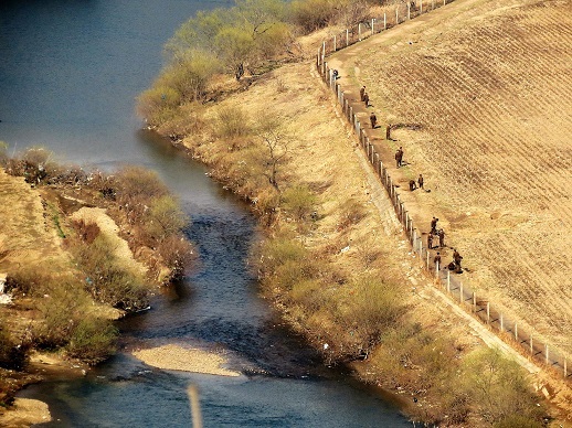
North Korea has 111 airports, airbases, heliports, emergency highway runways, and other landing strips. Particularly since 2016, nearly all of their emergency highway runways (straight sections of road that have been widened for use by aircraft in the event of a war) have had aircraft parking revetments constructed to augment each site. Additional basic runways have also had revetments constructed. In all, 15 airfields have had new revetments constructed. The number of revetments varies between one and four (most have three), but there is a grand total of 39 individual revetments which could support a combined 75 aircraft (at least) depending on type and parking arrangement.

It's important to note that not all of the satellite imagery of all of the different air facilities in North Korea has been updated to include either 2016 or 2017 imagery, so it's possible there are other sites that have had revetments constructed. I just can't yet see them.

Here are some examples of these sites. Click on any image to see an enlarged view.


Since my 2015 article on the North Korean Air Force and the changes that have happened under Kim Jong Un to the physical infrastructure of the Air Force and general aviation, at least three additional runways have been constructed.

Changdo, Kangwon Province (38.67993°, 127.72681°)


This runway is also approx. 3 miles (4.8 km) north of a military training base that underwent fairly substantial expansion in 2013.

Chongjin, North Hamgyong Province (41.80234°, 129.85480°)

This small auxiliary runway was constructed in early 2016.


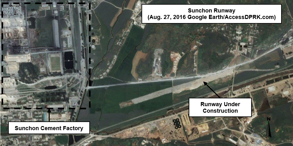
Sunchon, South Pyongan Province (39.44058°, 126.03576°)

This runway is being constructed across from the large Sunchon Cement Factory. Curtis Melvin at North Korean Economy Watch believes that this will be a new 'executive' runway for use by Kim Jong Un and other high ranking officials. What makes it odd, in my mind, is the fact there are two large military airbases (and a helicopter base) within 12 miles (19 km) of this new runway - after all Sunchon is an important industrial city.
Perhaps the 30 minute drive was a bit too much for the Supreme Leader.


North Korea has a history of testing missiles from their airports, particularly at Wonsan (Kalama) and Pyongyang International. During the modernization and expansion of Wonsan, an observation facility was constructed as well as two concrete launch pads on the beach. And as you can see in the opening image of this article, Kim Jong Un observed the test of a Hwasong-12 ICBM from Pyongyang International. But unlike Wonsan, the Pyongyang launch was carried out on the bare ground.

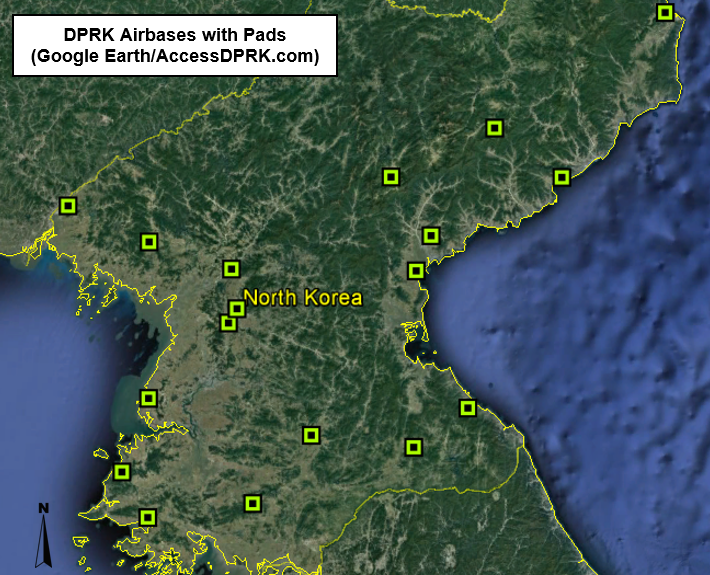
Along the line of launch pads, there has been a curious development at 19 of North Korea's major air facilities. Starting in 2015 and extending into 2016 (such a busy year), twin squares of concrete began to pop up at these airbases. Unlike the small launch pads seen at Wonsan or other sites, which are approx. 60 x 80 feet (18 x 24 meters), these new pads are each roughly 165 x 140 feet (50 x 43 meters). All but two airbases have two of these pads, one at each end and directly in line with the runway's path, but not connected to it. The other two just have a single pad. Most are made of concrete, but a few are simply areas of cleared land and compacted dirt.


My initial thought was that these were helipads, but they're much larger than most helipads in the country. Additionally, these are military bases and space already exists for helicopters. Furthermore, Pukchang Airbase (near Sunchon) has an adjacent helibase with dozens of helicopters stationed there, yet the main airbase also has these new pads. Use of these sites for helicopters is also lessened because the pads aren't directly connected to the runway and are separated from them by around 170 feet (51 m).

I am not an aviation expert, but I have explored the globe via Google Earth (and been to a few airports) and I have yet to see this layout anywhere else. My second thought then became, what if these are actually meant to allow rapid deployment of various missile systems? (Their size would accommodate everything in North Korea's arsenal.) I have asked for the input of others but wasn't able to get much more than "that's plausible", with no other firm alternative explanations. So perhaps North Korea now has 36 new ICBM launching sites, or maybe it's something else entirely. The fact these things popped up across the country, basically overnight, are fairly uniform in size, and are only located at major military sites, impels me to at least bring attention to them.


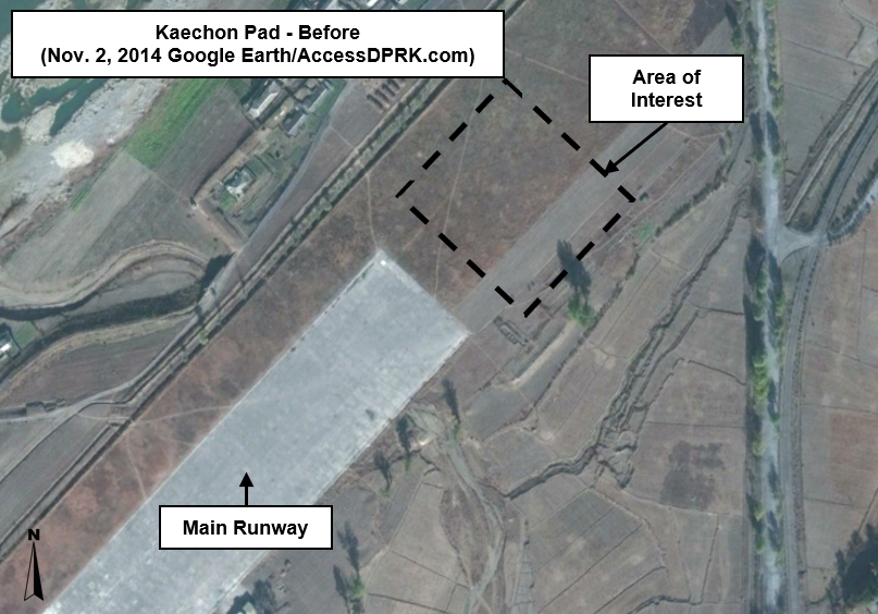
These two images shows the pad area at Kaechon Airbase before and after construction.


This next set of images is just a sample of different bases with the pads.


Here is the list of coordinates for each of the airbases with these pads.
Changjin: 40.36680°, 127.26304°
Hwangju: 38.65468°, 125.78629°
Hyon-ni: 38.61354°, 127.45410°
Iwon: 40.36044°, 128.71995°
Kaechon: 39.76226°, 125.91326°  (only has one pad)
Koksan: 38.68810°, 126.60147°
Kuum-ni: 38.86713°, 127.90625°
Kwail: 38.42360°, 125.02213°
Nuchon-ni: 38.23767°, 126.11891°
Onchon: 38.90914°, 125.23311°
Orang: 41.43005°, 129.64906°
Panghyon: 39.92883°, 125.20714° (Panghyon is near the site of the July 4, 2017 ICBM test)
Pukchang: 39.50491°, 125.96567°
Sondok: 39.75929°, 127.47621° (only has one pad)
Sunchon: 39.41134°, 125.89543°
Taetan: 38.13016°, 125.24616°
Toksan: 39.98743°, 127.60276°
Uiju: 40.15111°, 124.49965°


My ego isn't so fragile that I can't handle correction. If you think (or know) I have misidentified these sites or can offer a plausible alternative, please let me know!


--Jacob Bogle, 1/30/2018
www.JacobBogle.com
Facebook.com/JacobBogle
Twitter.com/JacobBogle

Thursday, January 18, 2018

North Korea's Great Barrier

I first wrote about North Korea's caged population in 2013, where I showed the fences that surround the country. Since then, I have been able to map the full system of fences, guard posts, and gates. And since the general situation regarding population movement has changed since then as well, I want to revisit the topic and also provide you with the Google Earth file so you, too, can explore the miles of fences and blocked off beaches, as well as to provide added evidence of the horrific human rights situation that exists. If you're primarily interested in getting the KMZ file, click here.

Guards maintaining a section of border fence along the Yalu River. (Source

First, a quick refresher. Much of North Korea's coastline and land borders are fenced off. According to multiple defector and media reports, some portions of fence are electrified while others are simply guarded by police. Of course the southern border (aka, the Demilitarized Zone/DMZ) has been turned into, perhaps, the most impenetrable 820,210 feet (155 miles) of border in the world. Ever. Apart from the hundreds of thousands of troops stationed along the DMZ, it has over 1,000 observation towers and forward military posts. Finally, the border with China (and the small section with Russia) is protected by large reservoirs, rivers, and in many places, fencing as well.
The purpose of these barriers is to keep people inside the country. Construction was sped up during the famine as the regime tried to cope with the mass movements of people, risks of defectors stealing boats, and as the government struggled to maintain their control in all sectors of society.

All of this means North Korea's population really is caged. A more colorful description of the country would be as an open-air prison.

The following images show the extent of the national fence system. Click on images for an enlarged view.


I was able to map nearly 1,400 miles (1,399.36 to be exact) of fencing. There are lots of small coastline sections where the paths of fencing can still be seen, but the fence itself is gone - likely pillaged for scrap metal by locals, however, most of the gaps you can see (and all of the large ones) are due to either natural barriers or where direct access to the sea/border is blocked by an industrial site, military base, or other construction that itself serves as a barrier.

Many coastal towns and villages lack a fence and instead the coastal portion is lined with dockyards and factories which requires locals to go through any number of gates or checkpoints, if they're permitted through at all. I've tried to map as many gate houses as possible that provide direct access to the coast. Ones that simply allow access to a factory or other site adjacent to the sea are not marked.

This next image shows the reason for each of  the major gaps in the fence system.


This image shows 837 identifiable police border guard posts and 434 stand-alone watchtowers along the the DMZ.


Under Kim Jong Un, miles of new fencing have been erected as well as older fencing upgraded in certain areas. A large number of additional watchtowers have been added along the fence routes as well, particularly in the northern regions. However, border controls extend well beyond fences and watchtowers. Cell phone single jamming towers, cameras, and other surveillance equipment have been deployed along both borders, but efforts have particularly increased along the Chinese border (which is the route most defectors take).

A related issue is the increased border protections China has been implementing. As with North Korea, China has begun to build fences (of a far greater quality than the DPRK) along certain key border sections to stem the flow of defectors. They have also constructed signal jamming towers and increased police and military patrols. China's active attempts to catch defectors by checking train stations, setting up road blocks, and patrolling neighborhoods, occur not only in the immediate border region, but far into the interior in major cities like Jilin.

The following series of images clearly show the individual fence posts and come from different parts of North Korea. Additional images can also be found in the original 2013 post, A Caged Population.


As both Kim Jong Un and China have taken a much harder line regarding border security, there has been a real and measurable effect on the numbers of successful defections. In 2017 there were 1,127 defectors who made it to South Korea, which is a decline of 27% from 2016. That was the lowest figure since 2001. The total number of defectors peaked around 3,000 in 2009, meaning there has been a decline of ~62% overall.

Despite the barbed wire fences, guards with automatic weapons, the high risk of women being sold into sexual slavery, and the risks of repatriation and imprisonment (or execution), people still brave the cold waters of the Yalu River and the forests of northern China to find their way to a better life. Even soldiers posted along the DMZ, who tend to belong to elite families and are generally more well off than soldiers stationed elsewhere, accept getting shot at 40 times (or even kill other DPRK soldiers) to cross into South Korea.

Kim Jong Un may have been successful in curbing overall defections, but the drive to feed one's family and the desire to experience the freedoms of the outside world (that North Koreans are increasingly being exposed to) will continue to inspire and embolden people to take the risks and seek a better life.

To download the full KMZ file and explore the sites yourself, click here. (Must have Google Earth to access.)


--Jacob Bogle, 1/18/2018
www.JacobBogle.com
Facebook.com/JacobBogle
Twitter.com/JacobBogle