Showing posts with label city planning. Show all posts

Wednesday, April 15, 2020

City Planning in the DPRK

Downtown area of the reconstructed Samjiyon. Off in the distance is a bronze statue of Kim Il Sung and "revolutionary history" museums at the base of the hill. (KCNA, 2019)


Plenty of people are familiar with Pyongyang and even other major cities in North Korea, but most of the population lives outside of the capital, Wonsan, and Sinuiju. Car ownership is still rare in North Korea, so even in Pyongyang, it doesn't take very long to find yourself on winding, narrow dirt paths. But the layout of streets is only one part to city planning.

The majority of the housing, stores, and schools in my hometown is in an area roughly 5 x 5 miles. That's a city with about 150,000 people. There are 14 North Korean cities with a population of 150,000 or greater. Excluding Pyongyang, the urban areas of those other 13 cities all fit within an area smaller than 5 x 5 miles.

And even Pyongyang, with 2 million people living in the main urban area, only occupies about 67 square miles. That is almost the same area as the federal district of Washington DC, which has a third of Pyongyang's population. This underscores the realities of how densely cities develop when cars aren't the "driving force" vs. how cities grow when vehicle ownership is viewed as a personal imperative. The result of that is North Korea lacks a lot of the urban sprawl that plagues many other countries.

Main urban area of Pyongyang.

Where you place important buildings, markets, or stadiums, it all matters, and it all says something about what the people and government find most important. This is all the more important when you're dealing with a walking and biking population.

City plans place what is important to the regime in the center and then from there follows places that would be important to the people (like small business districts that may have stores, a restaurant or two, and maybe a small hotel). To help us understand the overall city planning fundamentals in North Korea, I am going to detail two county seats, a smaller town, and then an even smaller village.

County seats follow two general layouts. A compact core of civic buildings and monuments around central plaza or a more spread out design where citizens encounter reminders of the state at multiple points throughout the city. The main difference between county seats and provincial capitals is that each provincial capital will also host large, bronze statues of Kim Il Sung and Kim Jong Il. Otherwise they tend to simply be enlarged versions of county seats with more industrial sites, more local businesses, and the occasional university.

Kophung, Chaggang Province is an example of the "compact" design.


As you can see, the main roads of Kophung channel people passed important reminders of regime power like the Juche Study Hall and the Tower of Immortality. The town hall is, of course, centrally located as well. Another thing to note is how far away the marketplace is.

While it's certainly within walking, it has been placed on the outskirts of town, something that is repeated in many of other locations. This is because most markets began as unofficial, even illegal, gatherings of people trading, bartering, buying, and selling. Some would be little more than an open area of ground where people would bring their goods, while others had small tents or other temporary structures placed at the site during the day or two the market was open.

As markets were slowly incorporated into the daily lives of most citizens, they became tolerated and then eventually regulated by the state. This allowed permanent structures to be built and they tended to be built where the informal market was already located - in the outskirts or other less desirable places.

Generally speaking, markets are also located some distance away from any key state symbols (like monuments), as they are somewhat regarded as an ideological stain (albeit one to accept). You can't have a blazing example of capitalism and individual freedom next to a monument to the communist "Sun of Mankind", Kim Il Sung.


In this close-up image, you can see that the line-of-sight from any direction you come, lands on the Tower of Immortality. These were first erected following the death of Kim Il Sung as monuments to his life and to reflect that his spirit will always remain. Indeed, Kim Il Sung is legally the "Eternal President" of the DPRK. The inscriptions on the towers were changed to include Kim Jong Il after he died. He is the "eternal" General Secretary of the Korean Workers' Party.

Additionally, every county seat (and provincial capital) have joint murals of Kim Il Sung and Kim Jong Il. During my 2018 survey of the country's monuments, I was able to identify 5,175 Towers and 265 joint murals.

Like elsewhere in the world, cities will usually keep their small industrial sites away from the city center. Many county seats also lack a stadium or dedicated sports field, but they will use the fields at schools. For those that do have a stadium, they are likewise set out away from the urban core.

Sepo, Kangwon Province is an example of the "spread out" design.


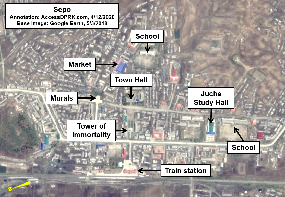
With the city of Sepo, the regime-focused structures are spread throughout the city, instead of in a single cluster. From the image's perspective, moving north from the train station (which is how most people arrive into town), there is a direct line of sight to the Tower of Immortality, and from there, to the town hall.

If someone travels down either of the main left-to-right roads, the joint murals will be visible at one end and the Juche Study Hall at the other (which happens to be surrounded by two grade schools. One is marked in the above image and the second is marked on the image below).


Every town has at least one "Juche Study Hall", they go by a number of different names including, palace of culture and Kimilsungism-Kimjongilism study hall. These basically play the equivalent role of churches in Europe and the Americas in centuries past. Centrally located, this is where people are required to go multiple times a month (at least) to be indoctrinated in the latest Party orders, to learn about the exploits of the leadership, and to hold "self-criticism" sessions.

Instead of struggling through alcoholism and freely talking about your journey in a safe environment, as in Alcoholics Anonymous meetings, self-criticism sessions could be described as meetings holding each other accountable for "wrong thought". But it goes much further than that. Everyone fails Kim Jong Un. Everyone holds thoughts incompatible with Juche. Everyone didn't try hard enough to study their best or to meet their quotas during work. Everyone fails and everyone is expected to come up with something to confess, whether or not they really did it.

And instead of being supported by their community, they are shouted down or accused by everyone in the group. These sessions can last hours, and defectors have spoken about the emotional trauma they cause.

Hwanggang-ri, N. Hwanghae Province is an example of a smaller town (38°20'16.79"N 126°47'8.90"E)


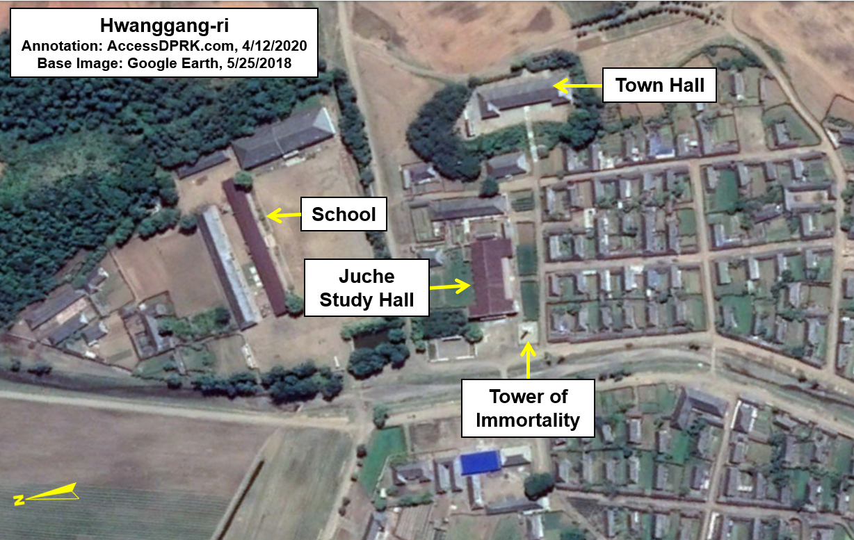
Hwanggang-ri is a small town with fewer than 2,000 people in the immediate area. It has a single, combined school where the elementary school and high school are within the same complex. From the perspective of this image, to the north of the Tower is the town hall and below the Tower label is a row of four buildings.

Each North Korean town has a medical clinic. Unlike schools or Juche buildings, these clinics don't always have a uniform style that is easily identifiable from satellite images. (Large hospitals are more easily discernible, but they're only in large cities anyway.)

In some places, the clinic is located inside the town hall and in others, a stand-alone building exists for the clinic. These clinics only offer basic health care functions, similar to a walk-in clinic that a pharmacy might have in western countries. They can diagnose a cold, give you something for a fever, stitch up a cut finger, or pop a shoulder back into place. They are not for MRIs or open-heart surgery. And given the state of North Korean healthcare overall, you probably won't find any antibiotics readily available, either.

A town this size is large enough to have a clinic, but whether it's in the town hall or in one of those four buildings, I can't say.

Unphyong-ri, Chaggang Province, is an example of a small village (40°52'51.36"N 125°46'20.17"E)


Even in small villages with only a couple hundred people, where having a separate building for Juche studies doesn't make sense, there is still a Tower, a town hall, and a school nearby. That simple organizational style is repeated in almost every populated place in the country. Only the smallest hamlets lack these things.

In the most rural parts of the country, schools are simple and may require a long walk, but it underscores the importance of basic education. Most students may only receive a limited education, but reading and basic math are fundamental to any functional society. 


As we have seen recently with the city of Samjyon, cities can be completely redesigned, demolished, and then rebuilt in the new design on the whim of the country's leadership. And many larger cities have had parts of their cores rebuilt or modernized at the direction of Kim Jong Un and through the national Korean Workers' Party. But local additions must be requested, approved by higher authorities, materials assigned, and then finally the buildings can be constructed. This means that a village might not see a single new home or even a repaired home for many years. Indeed, no new homes are visible in Unphyong-ri since 2009 and only two new homes were built in Hwanggang-ri since 2002.

And as we have seen here, no matter the size of the locale, there will always be a recognizable pattern in the plans of each city and village. They will place regime buildings and monuments in high visibility areas, schools will (often) be nearby, and signs of capitalism will be pushed to the side if possible.

Additional reading
A brief urban history of Pyongyang, North Korea - and how it might develop under capitalism, The Architect's Newspaper, by Dongwoo Yim, Aug. 24, 2017

I would like to thank my current Patreon supporters: Amanda O., GreatPoppo, Kbechs87, Planefag, Russ Johnson, and Travis Murdock.

--Jacob Bogle, 4/14/2020
AccessDPRK.com
JacobBogle.com
Facebook.com/accessdprk
Twitter.com/JacobBogle

Monday, December 25, 2017

Pyongyang's Thirty Years of Growth

Image of Mirae Scientists Street along the Taedong River. (Image Source: Rodong Sinmun.)


Like any national capital, Pyongyang is a dynamic and growing city whose fortunes rise and ebb as the fortunes of domestic and international affairs fluctuate. Pyongyang was founded in 1122 BC (according to legend) and served as one of the capitals of ancient Korean kingdoms. Over the course of the Korean War, the city - like much of the peninsula - was completely destroyed. Kim Il Sung spent enormous resources rebuilding the nation and redesigning Pyongyang into a showcase capital.
The attempt to use the capital to project power and showcase the miracles of socialism resulted in massive 'people's palaces' and numerous monuments, and peaked with the construction of the Ryugyong Hotel. Construction of the hotel, which was to be the tallest hotel in the world, was halted in 1992 (it still sits unfinished to this day). The fall of the Communist Bloc between 1989-1991 and the following famine of 1994-1998 resulted in the near total collapse of the North Korean economy.

Pyongyang itself suffered stagnation and large swathes of the city degraded. In the early 2000s, as gray and black markets began to rise, so too rose the fortunes of Pyongyang and the government has since embarked on a modernization program. The process was relatively slow under Kim Jong Il, but Kim Jong Un has overseen one of the largest building booms in North Korea's history.

One good and simple measure of the growth and strength of a city is population, unfortunately, population statistics are considered a state secret in North Korea, so getting accurate figures can be difficult - especially when you consider the widely varying figures concerning the number of deaths during the famine and the fact that there have only been two national censuses since 1980. Fortunately, the use of satellite information can help fill in some of the gaps by showing which areas have undergone urban growth. Contrary to what one may expect, despite all of North Korea's economic problems and the vast sums spent on military projects, the change in Pyongyang over the past 30 years is pretty astounding. A resident from 30 years ago would scarcely recognize the Pyongyang of today.


Thanks to Google Earth, historical Landsat and Copernicus satellite imagery dating as far back as 1984 is now easily available and covers most of the planet. Using this resource one can see the growth of cities and the spread of human development; an asset for studying a large number of topics. The outlines in the images below are densely populated urban areas that are contiguous within the outlined area. In other words, if there are two urban spaces separated by a large area of forest or farmland, they won't be included within the same outline.

In 1984, Pyongyang had an urban area of approximately 70.2 square miles (+/- 1 sq. mi) and by 2017, Pyongyang's urban area had grown to 103 square miles (+/- 1.5 sq. mi). At this point it's important to make the distinction between the capital region of Pyongyang and the core city of Pyongyang proper. The Pyongyang region is 1,233 square miles and has a population of over 2.5 million. However, within the region are 19 wards and two counties, and within all of those are dozens of smaller towns and villages. One of the larger areas within the region is Kangdong, which has a population of 221,000 and is around 20 miles away from downtown Pyongyang. So when considering population and population density of Pyongyang proper, it's necessary to exclude the populations of these satellite areas.

Here is a map showing the nine largest urban/industrial areas within the Pyongyang capital region as of 2017.


Outside of the city of Pyongyang and the growth of the airport, little has changed in the expansion of other urban areas with the exception of the city of Sangwon, which largely grew up as the Sangwon mine was established and the cement complex opened (in 1989).

To determine the land area of urban spaces, I outlined the areas and cut them into easily measurable geometric shapes. The white area is Pyongyang's main urban coverage in 1984, and the yellow represents 2017. It required over 200 individual measurements. You may find some areas that look like irregularities (yellow lines inside of white areas), and that's due to the fact that the image resolution for 1984 is much lower than that of 2017, making the 1984 area slightly less precise. I have tried to correct for this.


Beyond the simple growth of urban boundaries, the density of buildings has also changed drastically, particularly in a few key areas of the city. The change in total area of Pyongyang from 70 to 103 square miles is a comparatively slow growth rate when you look at other major world cities. Even my own medium-sized town has doubled in land area over the last 30 years. One reason for this limited growth is, of course, that residency in the capital is tightly controlled and has tended to stay at 10% of the national population. Another reason is the fact that there is no private land or home ownership (officially), so there aren't the endless subdivisions of single-family houses as seen in the US and other countries.

Pyongyang in 1984 showing some of the major areas of future construction. The Mansu Street area is already under development by this time. Image based on Google Earth and Landsat/Copernicus. 

Because of those facts, most residential units are in apartment complexes and single-story multi-family houses. There are three areas that really stand out to me as seeing the most growth and change over time: Ryomyong Street (which recently was 'opened'), Mirae Scientists Street, and the Tongil Street area which has been growing for the entire 30-year period.  A quick comparison of satellite images from 1984 (above) and 2017 (below) clearly shows the expansion of these and other areas, but I will only go into detail for the three I mentioned.

Pyongyang in 2017. You can see the large amount of development in the Tongil and Kwangbok regions as well as other changes such as the construction of the Ryungyong Hotel, the expansion of the Palace of the Sun, and the May Day Stadium which was built in 1989.

I'll begin with Tongil.
Tongil Street is a major road that runs east to west on the southern side of the Taedong River. Planning for the construction of the street (and associated buildings) began in the early 1980s along with several other smaller "street projects" like An San Taek, Munsu, Kwangbok, and Yanggwang streets. However, Tongil didn't see much real construction until 1991 when a speed campaign turned the area from farmland into a booming work site.

The Tongil Street area in 2017. 

As you can see in the 1984 image of Pyongyang, nothing existed in this area at the time. Since construction first began in the 1990s, Tongil Street has undergone almost continual growth. Other areas have also grown out from Tongil and now include the Pyongyang University of Science and Technology (PUST), Chollima Building Materials Factory, and the Pyongyang Catfish Farm.


Google Earth image of Mirae Street on May 10, 2001.

The next street is Mirae. Mirae runs along the northern bank of the Taedong River, across from Yanggak Island. "Mirae Scientists Street" was developed to house faculty and their families as well as various institutions of the Kim Chaek University of Technology. The development included over 2,500 apartments and boasts one of the tallest buildings in Pyongyang, the 53-story Mirae Unha Tower. However, many of the apartments on higher floors of the various buildings remain uninhabited due to a lack of electricity to power elevators and heating units, despite being completed in 2015. Additionally, the development came after a 23-story apartment building collapsed, killing dozens of people. These two factors have likely played a role in the slow pace of occupancy.

This brings me to a larger issue that plagues North Korea. The country has relied on Stakhanovite mass-mobilization speed campaigns (like the Chollima Movement) to construct large projects at a neck-break pace. From hydroelectric dams to large buildings, the government forces their completion within a year or two at most (if they get their way) when in reality, these things should take upwards of 5 or 10 years to be done safely. While Pyongyang may now be bustling with rather striking looking and shiny new buildings, the soundness of their construction and long-term safety is deeply questioned.

Google Earth image of Mirae Street on May 1, 2012. You can see some apartment buildings have been built since 2001.

Modern Mirae Scientists Street, also nicknamed "Pyonghattan".


The last major development I am going to focus on is Ryomyong Street, which was only opened in April 2017. Running roughly southwest to northeast, the street connects the 15 April House of Culture and the 92-meter (302 foot) tall Tower of Immortality with Kim Il Sung University and the enormous Palace of the Sun, which now serves as a billion dollar mausoleum for Kim Il Sung and Kim Jong Il's bodies. The new towers offer thousands of additional housing units.

The bright buildings of Ryomyong Street at night along with the newly renovated Tower of Immortality. (Image Source: ExploreDPRK.com)

Kim Jong Un ordered the construction of the area's redevelopment in March 2016, meaning the multiple residential buildings (including one that has 70 floors), stores, and restaurants were all completed in less than 13 months - which again calls into question the quality and safety of the buildings. There is a second phase of the project, which is still ongoing, that is expanding Kim Il Sung University and constructing new housing further up the street. Funding for the "200 day speed battle" to build the area came (at least in part) from the government's demand that families hand over $50 to pay for it. While $50 may not sound like much to us in the West, it's enough to purchase 80 kg (176 pounds) of rice on the market. It's also the approximate equivalent of 2 weeks' pay. These funds are on top of a seemingly never-ending demand for "loyalty payments" and other fees citizens are required to regularly come up with.


There has also been inevitable change to the more rural areas of Pyongyang. Multiple small villages have been demolished and rebuilt along more efficient lines. Not only does this help with local housing shortages and the badly needed replacement of dilapidated homes, but the greater efficiency of the layout results in more usable farm land in the aggregate, even if it's just a few added acres here and there.

Some of the rural areas with newer housing.

Here is a close-up example of the demolishing of a small village, with its older housing and more haphazard layout, and at the same time, the construction of modern houses in another village about a kilometer northeast.

Unnamed village in Pyongyang that was demolished in 2017.


Finally, here's a map showing many of the areas of Pyongyang that have experienced major new construction or redevelopment since 2009 (includes some industrial areas). I chose 2009 because that was the first year after Kim Jong Il's stroke and the year Kim Jong Un officially began to be groomed to take over for his father.


Pyongyang, like the rest of the country, continues to grow despite sanctions or the highly unstable and wasteful model of having parallel military and domestic economies which has governed the country since the early days of Kim Il Sung. The rise of markets and an unofficial middle class means that there is more individual interest in living in nice apartments - and that there's money to go around to make construction happen. Additionally, Kim Jong Un is keen to make his mark in all areas of concern, with major construction projects being seen in every large city across the country. Kim III will undoubtedly go down in history as the man who brought North Korea's nuclear program to completion, but he will likely also be noted for spending billions on national construction; perhaps the largest builder since his grandfather. However, history will also mark whether or not all of the energy and wealth poured into these projects was worth it, or if it had no net positive effect on the people and only served to drain badly needed resources as the skyscrapers of Pyonghattan eventually collapsed one by one.

--Jacob Bogle, 12/25/2017
www.JacobBogle.com
Facebook.com/JacobBogle
Twitter.com/JacobBogle

Additional reading
1. 2008 DPRK Census Report (PDF)