There are over 2,500 underground sites in North Korea that have been publicly verified. They fall into five main categories: Hardened artillery sites, underground factories, underground storage facilities, underground air bases, and the underground facilities at missiles bases. There's also the large underground nuclear test site at Punggye-ri, several underground navy bases, and some others that are used for communications and emergency command sites, but those only make up a small number of the overall sites.
Other estimates place the number of underground facilities (UGF) as high as 14,000, but that would include everything from civilian bomb shelters to not-exactly-underground covered bunkers. And things like bomb shelters beneath apartment buildings isn't something that using commercial satellite imagery can easily work out.
So, of the ~2,500 UGFs that I can directly point out to you, a few stick out as being exceptionally large.
A note on estimating sizes. There are several fairly easy ways to estimate the size of an underground facility. The simplest of which is to look at the spoils dumped outside. Measuring the width and height of the rock piles can give you an idea of the volume being excavated. You can also consider the purpose (if known) of the UGF and what it might require in terms of size, you can look at the distances between entrances and service adits, and take into account the geology of the hill/mountain being tunneled into.
Unfortunately, many North Korean UGFs don't have spoil piles to examine; the debris having been carried away to better hide the size of the facility. And looking at the distances between entrances only tells you that a tunnel exists, not necessarily a large complex with multiple floors and a warren of passageways.
And, unlike underground airbases or artillery sites, not every UGF in the county has been assigned a purpose within open-source intelligence. That adds another layer of difficulty in estimating the size of a facility.
Therefore, this list comes with a few limitations. But whether or not this list contains the literal 14 largest UGFs (excluding missile bases) they are nonetheless among the largest in country. Some are rather astounding in size, at least to me, considering the state of North Korea's technology and the tools and skills they have available.
With that in mind, here are 14 of the largest underground facilities in North Korea.
Arms factories
The Kanggye General Tractor Plant (40°57'28.72"N 126°36'22.75"E) is the largest underground arms factory in North Korea. Also known as Factory No. 26, it was established soon after the Korean War after the original small-arms factory was split into three, and each part moved to different areas of the country.
The term "tractor" comes from Soviet nomenclature that typically denotes a military factory, with tractors rarely being made at "tractor" factories. Mortar ammunition, rifle ammunition, and self-propelled artillery ammunition are among the more common items produced at the factory, but they are also responsible for manufacturing short-range missiles.
Externally, the factory covers around 99 hectares. However, the factory has multiple underground entrances that provide access to the interior of a 1.8 km-long hill. While the exact size of the plant isn't known, the height of the hill would allow for multiple factory floors and several kilometers of tunnels.
It is estimated that the plant employs at least 20,000.
One of its biggest chapters occurred on Nov. 30, 1991, when an explosion rocked the factory.
However, Landsat imagery from the time does show that something major happened at the factory.
Based on measurements of the imagery, the explosion destroyed an area nearly a kilometer wide and likely damaged every above ground building in the factory complex as well blew out windows for kilometers around.
It has been alleged that the explosion killed around 1,000 people. If true, that would make it one of the deadliest defense industry-related disasters in history, perhaps only second to the 1917 Halifax Explosion which killed nearly 1,800.
It took 3-4 years for the site to be cleared and reconstructed, and, possibly as a legacy of the explosion, no new residential buildings have been constructed facing the factory, although the area does remain populated.
Panghyon Aircraft Factory (39°53'6.52"N 125°13'56.52"E)
First constructed in the 1960s, this factory used to be North Korea's only aircraft factory and it is still the primary factory that produces replacement parts for the country's fleet of aging MiGs and J-6 copies.
The factory is nearly 1.5 km long and is positioned around a hill. The primary underground entrance is ~14 meters wide and with 91 meters of overburden, a very large underground factory could exist, occupying upwards of 100,000 sq. meters.
It is believed that during the 1990s and early 2000s centrifuges for uranium enrichment were manufactured and stored at the factory, with as many as 300 centrifuges being held there. This provided a critical industrial component to North Korea's nuclear infrastructure. There is no indication that the factory is still produces centrifuges today.
Panghyon has also been the site of ballistic missile launches including a Hwasong-14 ICBM launched on July 4, 2017.
Tonghungsan Machine Plant (39°57'11.97"N 127°32'48.35"E)
Tonghungsan is a large factory that is suspected of producing missile components and parts for mobile launchers. It is split into two main sections, above ground production facilities and the underground complex.
The above ground part of the factory has been undergoing a complete reconstruction since 2016 and now includes 19 production-related buildings, 11 administrative and support buildings, and the reconstruction also involved building 31 residential buildings and several other structures such as schools and cultural/communal sites.
The construction also extended to the entrance and security buildings that lead to the underground entrance. The primary entrance has two portals that are 60 meters apart. A service adit (portal) is visible 140 meters north and piles of excavation spoils can also be found 400 meters from the main entrance, and another pile is 820 meters away. Yet another adit is also located on the other side of the mountain, 1.3 km away from the entrance at 39°57'45.31"N 127°32'13.21"E.
Simply connecting these visible parts of the UGF suggests that there could be at least 291,000 sq. m. of underground space. If there are multiple levels, that could reach upwards of 400,000 sq. m. given the area's geology. Of course, large underground facilities aren't massive single caverns. They have galleries (halls), support structures, and may need to avoid weak spots in the rock, so the real size of usable space will be less than 400,000 sq. m., but it could still be the equivalent in size to an automobile factory or the Louvre Museum, all beneath a mountain.
Major Underground Airbases
Twenty-one North Korean airbases have underground facilities, but the following six bases represent the largest in terms of the underground tunnel length and the amount of possible internal space.
Koksan AB (38°40'34.89"N 126°35'40.69"E)
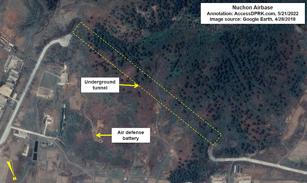
Nuchon AB (38°13'52.09"N 126° 7'43.57"E)
Nuchon consists of a single 2,495-meter-long runway and is home to the 32nd Air Regiment (fighter-bomber) and is home to several J-5/MiG-17, MiG-21PFM, Mi-2 aircraft.
The tunnel connecting the two underground entrances is 575 meters long. At a minimum, the UGF covers 18,450 sq. m. but the hill above contains enough overburden to support a theoretical UGF up to three times that size if there are galleries that branch off the main tunnel.
Onchon AB (38°53'13.32"N 125°16'29.39"E)
Onchon is unique in that it has the only fully functional underground runway in the country. The base's primary runway is 4 km to the west.
Onchon is home to the 36th Air Regiment (fighter). At least 36 aircraft are stationed at the base.
The underground complex consists of an underground runway, with 700 meters of it going underground, and two underground entrances used to bring aircraft inside of repair and storage facilities. The two entrances are 280 meters apart.
Connecting the entry tunnels and underground runway area together would yield a UGF of 51,800 sq. m. If the internal layout is more complex with extra galleries, the theoretical maximum size grows to roughly 160,000 sq. m.
Pukchang AB (39°30'44.60"N 125°57'28.76"E)
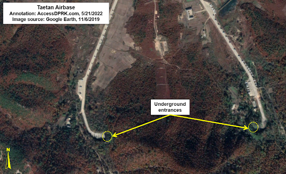
Taetan AB (38° 7'3.70"N 125°13'21.97"E)
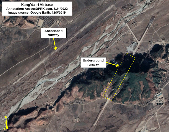
And lastly, Kang'da-ri AB (39° 5'48.78"N 127°24'51.67"E)
Like Onchon, Kang'da-ri also has an underground runway, but the facility doesn't appear to be actively used by aircraft, leaving Onchon as the only active underground runway in North Korea.
The Kang'da-ri complex consists of a primary runway on the left bank of a river and an underground runway. The primary runway was modernized in 2009/2010 but has since been abandoned and left to deteriorate each time the river floods.
The underground history of Kang'da-ri goes back to 1998 when the initial excavations into the small mountain began. Work has carried on in fits and starts, with the most recent work appearing to have stopped in 2018.
The paved portion of underground runway is 1,748 meters, with ~750 meters of that actually being underground.
It has been claimed that the base is part of the 2nd Air Combat Division, but no aircraft can be seen in any of the images available on Google Earth. Additionally, Joshua Stanton has said that the runway is too small for fighter aircraft.
The true purpose of the base is unknown, but part of North Korea's chemical weapons program is said to be based at Anbyon, a town just 11 km away. However, there are few military facilities at Anbyon that would be suitable for chemical weapons storage, but the underground Kang'da-ri runway is protected by large blast doors and it cannot be directly accessed by any major highway - adding to the site's security. So I think the base is a candidate location for weapons' storage (chemical or otherwise), particularly since the government has seemingly taken 24 years to build an incomplete "airbase".
Unidentified large UGFs
Hagap has been written about extensively (including on this site here & here), but it is in this section because we still don't know what the place is actually supposed to be. The two prevailing theories are that it's either an underground uranium enrichment plant or that it is part of the national archives.
The enrichment theory was put forward the moment Hagap became publicly known about in 1998. Given the construction of the Kangson enrichment plant near Pyongyang, and that Hagap still has not been completed, it would make its existence redundant (and very expensive) as an enrichment site. However, it could play any number of other roles within North Korea's nuclear program.
The other theory put forward is that it is meant to ultimately become an archives facility capable of protecting the most important documents and artifacts from even a nuclear blast.
After several years of apparently being dormant, new construction began at Hagap in 2011/2012 with a new underground entrance being excavated and the spoils were used to lay the foundation for an access road. This work was carried out methodically until in 2015/16 the pace of construction was sped up and new work could be seen throughout the eastern side of the complex.
This construction coincided with underground work being carried out at the International Friendship Exhibition located a short 8 km away. The IFE is where North Korea houses the countless gifts, medals, and awards given to the country's leaders over the decades and is used in propaganda as proof of the greatness of the Kim family.
Concurrent construction at both sites could merely be coincidence, but I think it might add a little weight to the theory that Hagap is actually meant to be part of a highly secured national archives, perhaps holding the true histories of Kims and government that are too dangerous to be accessed by anyone but the most devout followers of Juche or that it will hold the foundational documents and artifacts of the country to protect them from war or natural disaster.
Based on the locations of the underground entrances, there is a primary tunnel capable of handling vehicle traffic that runs for ~500 meters. The facility very likely also extends within the mountain for another 400-500 meters.
Sonjesan UGF (39°18'46.95"N 125°55'33.74"E)
Sonjesan is an interesting site. It is located in a random hill halfway between Pyongsong and Sonchon. It has no obvious industrial infrastructure or particularly tight security. At the same time, the roads leading to the UGF also go through multiple nearby military facilities, and it has four entrances.
The main entrance is at 39°18'46.95"N 125°55'33.74"E but the above image is centered on the two rear entrances at 39°18'35.52"N 125°55'50.47"E because they show up the clearest in the available imagery.
Connecting the four entrances into a simple rectangle yields a potential area of 95,700 sq. m., that's over a million square feet. Sonjesan also has visible spoils piles and examining those shows that at least 100,000 cubic meters of material has been excavated out of the hill.
In 2020, the original buildings at the main entrance were demolished and new ones built. Another point of excavation that is almost certainly connected to the primary UGF was also opened in 2016, with the spoils pile growing each year into 2021. The pile contains approximately 6,300 cubic meters of material.
A nearby sixth site was constructed in 2017/18 at 39°18'14.84"N 125°55'40.66"E, along with a new military base, but I'm not sure if this tunnel connects to the main facility or if it's simply its own small UGF.
Taedonggang UGF (39°10'25.07"N 125°56'43.60"E)
Located by the Taedong River, near the Kangdong Leadership Residence, its four entrances are spread out along nearly 300 meters and the site could also be connected to a large artillery position 520 meters away that itself has an underground component.
The four entrances are grouped into two groups and I don't think they're connected to each other. So the actual underground facility may not technically be among the largest because of this, but the overall complex itself it rather large. The particular layout of the UGFs is also uncommon.
The roads leading to the entrances are also quite wide and would allow access to vehicles that have wide turning radii such as missile launchers or large artillery systems.
Interestingly, at the end of the base is a large overhead crane, such as one might see at a containership port or factory. New buildings were added at the crane site in 2019. The presence of the crane could suggest that the base is, in fact, used more for storage and maintenance (perhaps even of industrial equipment) than as an active missile or artillery base.
Abandoned/Unsused UGFs
The Kyongje-dong Bunkers 38°34'36.46"N 125°56'8.15"E
The initial preparations for construction took place in the 1980s, but primary excavation work began in 1993. The facility was completed in 1998.
The two bunkers have entrances 40-meters wide, and they each have a large concrete pad in front that measures 60 by 40 meters. The entrances are protected by blast doors, and the earth-covered bunkers themselves are approximately 60 meters long.
The CSIS report goes on to say that the facility is most likely a reserve site that would serve as a forward operating base for MD-500 helicopters in the event of war, allowing special forces operations to penetrate much further into South Korean territory than other existing heliports would allow.
Hamhung abandoned UGF - 39°59'50.27"N 127°42'52.09"E
Looking at historical imagery on Google Earth shows that work began at the site in 1996 and work was ongoing in 2008. The UGF sits at the end of a valley, with the rest of the valley filled with numerous support buildings spanning 1.7 km. But by the early 2010s, work was halted. Nearly all of the buildings were then removed in two phases, one in 2016 and the other in 2021.
The primary tunnel face is ~45 meters wide and there is what looks to be a large metal frame to hold protective doors. A second entrance was created but has since been closed, possibly as the result of rock collapsed.
The crane that was used to move materials into dump trucks has been kept in place.
It's still possible that the site used to be a mine, but if so, its design is unique in North Korea. If it was meant to be an underground facility, I think geologic problems developed as they dug deeper into the mountain, perhaps causing severe leaks or internal collapses. This wouldn't be the first time a UGF in the country had to be abandoned due to collapse. A coastal defense battery had a large cave-in back in 2016.
I also want to add an honorable mention to the network of tunnels that protect the Kim family. These road and rail tunnels connect various palaces and military command centers together, enabling the Kims to move around the country securely during a time of war or to evacuate one place and get to another. Most of this network is still hidden but there are some known/suspected parts of it that rise to the surface and can be seen by all.
One tunnel is particularly well known. It is a two-lane paved road (39° 9'50.83"N 125°59'26.98"E) that dives beneath the Taedong River near the Kangdong Palace and then reemerges a kilometer away. It is surmised that there is another tunnel that pulls off from the main one and connects to other elite areas in the region.
Another part of the network uses the country's railways. The Obong-ri Elite Train Station (40°18'18.13"N 125°12'18.72"E) is positioned in a mountainous region north of Kusong. The entire complex encompasses roughly 17 sq. km and contains two train stations, housing for personnel, various support structures and it has two rail lines that go into a hill and disappear. It is not known if this is simply an underground train repair center or if the lines continue underground and could carry Kim Jong-un many kilometers away on his armored train without anyone knowing.
I would like to thank my current Patreon supporters: Amanda O., GreatPoppo, Joel Parish, John Pike, Kbechs87, Russ Johnson, and ZS.


No comments:
Post a Comment