Thursday, January 5, 2023

Pyongsan Uranium Plant Reservoir Expansion

On New Year's Eve, following the Sixth Enlarged Plenary Meeting of the Party's 8th Central Committee, Kim Jong Un laid out his plan to "exponentially increase" the number of nuclear warheads North Korea has. Current estimates are that North Korea has enough fissile material for up to 55 warheads, has assembled ~20 weapons, and has a production capacity of one bomb every two months. 

Publicly announced plans are rarely made prior to any foundation work being done. Whether its massive new farms, high-rises in Pyongyang or new weapons, by the time an announcement is made the plans are often already in the process of being carried out.

To dramatically increase the number of warheads, the country would need to ramp up uranium and plutonium production. On the uranium front, the Pyongsan Uranium Concentration Plant is North Korea's primary facility for the production of yellowcake uranium (80% uranium oxide). From there it is sent to the Yongbyon Nuclear Scientific Research Center for enrichment to weapons-grade uranium. The number of centrifuges at Yongbyon is a major bottleneck in their ability to increase the manufacturing rate of warheads, but there are signs that North Korea has been trying to resolve this as well.

At Pyongsan, the waste material from the plant is sent to a reservoir about 300 meters away, across the Namch'on River. I have written about the deficiencies of this reservoir and the risk of river pollution from the complex, but it seems like North Korea has been planning for its continued use through ongoing uranium production for some time.

Depending on the exact height of the dam, the current reservoir has 35 hectares (86 acres) of usable space. In 2006, the visible area of precipitated waste sediment was roughly two hectares (4.9 acres). That had increased to 6.1 hectares (15 acres) by 2017. 

There is some variability in what can be seen and measured due to seasonally changing water levels within the reservoir, but the area of visible waste now covers at least 13.2 hectares (32.6 acres); however, the solid pile has nearly reached the same level as the top of the embankment dam and has blocked off one of the reservoir's main lobes, limiting the reservoir's lifespan and risking flooding/overtopping events each time there's heavy rain fall. 

Historic extent of visible waste material for 2007, 2017, and 2022.

If Kim Jong Un is serious about adding dozens or hundreds of new warheads to his arsenal within the next decade or so, Pyongsan is going to need more space to hold its toxic waste, and it looks like that is exactly what's happening now.

Google Earth now shows a reservoir expansion that's in the early days of construction. The current reservoir sits within a series of low hills and shallow valleys. The valley immediately east of the reservoir is being prepared to serve as a future storage site. 

In early 2022, a mere 120 meters away, a trench was constructed leading from the current reservoir into the new valley. And at the end of the valley, nearly a kilometer away, the foundations for a new dam were being excavated. 

This 175-meter-long trench will carry a pipe from the old reservoir and into the valley along the path of a small stream, allowing it to fill using gravity.

Nearly a kilometer southeast of the trench, this future dam will block the valley to create the reservoir. It will be around 165 meters in length.

Depending on the finished height of the dam (as constrained by the abutting hills), the usable size for this new waste reservoir could be between 16 and 19 hectares (39-47 acres). The current reservoir was constructed in 1990, but activity at Pyongsan has historically not been constant, with several periods of little-to-no production. But if the last ten or so years of production levels are any guide, this new reservoir could hold another 15-20 years' worth of waste material on top of what can still be added to the existing reservoir, which could still be operational for the next ten years depending on the depth of its western lobe.

Since the current reservoir still has life, there may not be a need to rush the construction of this new site. But the fact it has been planned and initial work carried out speaks to the long-term plans of Kim Jong Un, and that is to keep uranium production going for as long as possible. 

One thing that I will be interested in watching for is whether or not the new reservoir will be lined with protective sheets (the current reservoir isn't) or if any mitigation efforts will be undertaken to prevent leaks into the ground water and into the larger Ryesong River which is just 2 km away and flows toward South Korea. 

All of this is happening as 2022 became a record year for the number of missile tests carried out, far surpassing any other. And it is happening following announcements in 2021 surrounding the development of tactical nuclear warheads, hypersonic glid vehicles, and continued work on submarine launched ballistic missiles. Kim Jong Un has made it very clear he wants to develop a dizzying array of new weapon systems, and the expansion of this reservoir is a practical infrastructure step toward enabling North Korea to engage in the types of industrial activity needed to eventually produce them in the long-term.


I would like to thank my current Patreon supporters: Alex Kleinman, Amanda Oh, Donald Pierce, GreatPoppo, Joel Parish, John Pike, JuneBug, Kbechs87, Russ Johnson, and Squadfan.

--Jacob Bogle, 1/5/2023

Tuesday, January 3, 2023

AccessDPRK in 2022

This last year was a great one for AccessDPRK, and thanks to your continued readership and for the support of Patreon backers, 2023 has some very cool things in store.


There were two main events for the AccessDPRK project in 2022. The first is that I completed the series Kim Jong Un's First Decade in Power. Spanning twelve articles written between August 2021 and February 2022, it represents one of the most detailed records of his first decade as leader of North Korea and it was the most ambitious writing project that I've undertaken for the blog.

The other big thing for the year was being featured in an episode of Super Users for VICE World News. The online episode "What North Korea Doesn't Want You To See" was published on September 21 and has since received nearly 4 million views. 

Thanks in part to the video, the blog also received the most annual traffic ever, surpassing 2021 by over 40%. On Twitter, the account gained over 300 new followers and the most popular tweet for the year was introducing the article about North Korea's largest underground facilities which got over 50,000 impressions.

This went on to spur some media attention with reporting in Metro, UNILAD, and The Sun.


With the 14 articles published this year, the blog now contains 156 articles that equal the equivalent of 1,063 pages of material and includes 1,023 images. I have also made public 14 city briefs out of the 36 that have been created so far, and I will continue to publish the rest this year. 

As part of those articles, I was able to review over 1,500 air defense sites and create the most up-to-date map of all of their locations, I detailed the layout of the DMZ and its various fortifications, and I was able to shed some more light on North Korea's large underground facilities as well as archeological sites.

The top 3 most-read articles for 2022 were:

1. The Largest Underground Sites in North Korea

2. Tunnels to Nowhere

3. Phishing for AccessDPRK


Looking to 2023

There are always things left to do and new ideas for the future. As I mentioned last year, I started working on a book and I will continue that this year. I will also keep publishing the existing city briefs, but those were created with the help of a dedicated sponsor and the future of that project is uncertain, but I will address that more when the time comes.

I have ongoing mapping projects for housing, land reclamation, and military land usage. They are rather large projects but I'm hoping to finish at least one of those this year while also maintaining regular posts here. (I perpetually have a list of 15-20 article drafts to work on, so there's always going to be something to share.)

Additionally, since last year I have been assisting Human Rights Watch with a major report that's related to North Korea's anti-pandemic efforts and how they've impacted the economy. The exact publication date hasn't been set but it should be sometime this spring.

Lastly, I have begun to review and update the 2021 map. Whether or not this gets turned into a full-blown new version or simply an occasional update I haven't decided. Regardless, there's been around 4,000 additions, improved categorizations, and other changes made so far. In the end, most of the changes won't involve new places mapped (although there will be plenty), but I'm wanting to focus on its usability and on adding as many relevant details as possible (construction dates, official names, types of equipment, related news stories, etc.) There is no timeline for this, it's just something that I want to start digging my teeth into.


Patreon

Over the years AccessDPRK has helped alert South Korean authorities to the risk of industrial pollution from North Korea, was the first to detail activity at the Kyo-hwa-so No. 88 prison, created the first detailed surveys of North Korea's gas stations and monument construction under Kim Jong Un, and has kept tract of everything from border control changes to missile bases and market activity. Information from AccessDPRK has also been used in reports from RAND Co., NK News, 38 North, DailyNK, JoongAng Daily, Nikkei, RFA, Asahi Shimbun, UPI, the OECD, and many others. 

Patreon supporters enable me to devote more time to mapping, in depth research, and writing. With support levels ranging from $3 to $20 a month, rewards can include getting article copies before they're published, having locations personally analyzed by me, and even get access to sections of the 2021 Pro Map.

If you're not able to support the project on a monthly basis but would still like to help, you can also help with a one-time $5 donation via Buy Me a Coffee.

I would like to thank my current Patreon supporters: Alex Kleinman, Amanda Oh, Donald Pierce, GreatPoppo, Joel Parish, John Pike, JuneBug, Kbechs87, Russ Johnson, and Squadfan.


For past annual reviews, see 2021, 2020, 2019, and 2018.

--Jacob Bogle, 1/3/2023

Wednesday, December 21, 2022

Dissecting the DMZ

I've written about the DMZ before, discussing how it has changed over the last decade or so. But now I would like to go into greater detail about its actual functionality - how it's laid out, what kind of defenses exist, and what kind of offensive capabilities are contained within.

The DMZ (demilitarized zone) is defined as a buffer zone between the two Koreas. It extends for 250 km across the peninsula and is approximately 4 km wide. However, the only fully defined part of the DMZ is the "military demarcation line" (MDL) which is the de facto land border - the actual line dividing the countries. On either side of that line is the buffer zone, which happens to be the most militarized area in the world.

In practice, the part of the DMZ that is actually devoid of any soldiers varies considerably in width. And the width of the various integrated defenses on either side of that no-man's land also varies. For the purposes of the AccessDPRK maps and this blog, I classify military sites within 5 km of the military demarcation line on North Korea's side as "the DMZ", because within that area lies an almost uninterrupted web of observation posts, storage sites, bases, artillery positions, and other sites that clearly form a unified military infrastructure.

General DMZ overview. The military demarcation line (MDL) is in yellow, and the two rows of electrified DMZ fencing are in white.

Detailed look at the DMZ's layout with the MDL dividing North and South Korea, an empty "no man's land" (green area), and the two heavily militarized fences on the North's side.

What became the DMZ largely reflects the battlelines as they existed in 1953. On the North Korean side, relics of the Korean War can still be seen including cratered hillsides and trench remains. And many of the extant static defenses such as anti-tank ditches and dragon's teeth can be traced to the 1960s and 1970s. Although some of these sites have been heavily impacted by erosion and would offer little practical defense today others still exist in good condition, and the manned instillations along the DMZ are routinely maintained and hundreds of new sites have been constructed over the years.

With thousands of manned positions and hundreds of kilometers worth of trenches and anti-tank ditches, the DMZ is a considerable defensive line. Because of this complicated layout, I want to try and "dissect" it piece by piece. 

One last note, the images used are chosen because they provide a clear view of the site being looked at. Image quality can vary a lot, so the most recent image may not display the best visuals. Perhaps there's cloud cover, it's too dark, too bright, at the wrong angle, etc. However, if an image I've chosen does happen to be from several years ago, that site still looks the same as it does in recent images. The older image is simply "prettier" and makes it easier to show the necessary details. 


Order of Battle

The exact details of North Korea's order of battle aren't fully known publicly, but what is known would still take up more room than I have for this post. However, the Ministry of Defense (formerly the Ministry of the People's Armed Forces) deploys roughly 70% of its active duty ground forces south of the Pyongyang-Wonsan line that lies roughly 120 km north of the DMZ. A substantial portion of the Navy and Air Force is also positioned within that area as are five short-to-medium-range ballistic missile bases.

Some of the details include that the DMZ is manned by members of the Korean People's Army I, II, IV, and V Corps according to Joseph Bermudez's book The Armed Forces of North Korea. Their operations are under the command of the Third Department of the General Staff Department's Operations Bureau which is part of the Ministry of Defense and subordinate to the State Affairs Commission.

These Corps represent the First Echelon of KPA Ground Forces and defend the DMZ and the areas immediately behind it. The Second Echelon of forces (which include the 820th Tank Corps and 815th Mechanized Corps) are tasked with defending the main invasion avenues into North Korean territory on the approaches to Pyongyang.

Each Corps will have their own specific makeup but, in general, they will consist of light infantry brigades, artillery brigades, tank brigades, sniper units, anti-tank units, electronic warfare/SIGINT units, reconnaissance units, communication and transport units, engineering regiments, and others. They will also have units assigned to chemical warfare and nuclear defense (although not nuclear weapons).

Special Operations Forces are also deployed along the DMZ and are under the command of the Reconnaissance Bureau and Light Infantry Training Guidance Bureau. 

The 3rd Air Division is responsible for protecting the south of the country and the DMZ. Immediate aerial support could be provided by the eight closest primary airfields and would include support from SU-25s, MiG-17s, MiG-29s, An-2 biplanes, and MD-500 and Mil Mi-2 helicopters (among other manned aircraft and UAVs). There are also 29 additional runways, landing strips, heliports, and emergency runways within 100 km of the DMZ. And, of course, fighter and bomber aircraft could be sent from any of the airfields in North Korea, not just the ones in closest proximity. 

Ballistic missiles under the control of the Strategic Rocket Forces would be used to destroy key targets within South Korea and to help Special Operations Forces disrupt and push back an invasion by South Korea by opening up a "second front". 


Invasion Routes

Hypothetical south-to-north land invasion routes based on favorable geography.

Several portions of the DMZ serve as natural invasion routes that could be used by either side to invade the other. From a defensive perspective, the North Korean fortifications would stall an invasion coming from the South that would likely be funneled through the low and flat terrain between Kaesong to Pyongyang (an invasion route that has been used historically for over a thousand years), north toward the city of Koksan which would take out several important infrastructure sites and also grant access to Pyongyang, from the South Korean city of Cheorwon to North Korea's Sepo and through a valley into Wonsan (cutting Kangwon Province in two), and lastly through the narrow plain that exists along nearly the entire east coast (also an historic invasion route)

To help slow down a ground invasion, a network of unmanned static defenses has been constructed over the decades. Many have been impacted by time and erosion, but the sheer number and breadth of them means that they remain an obstacle that would have to be taken into consideration.


Unmanned Anti-invasion Defenses

Except for a mountainous border region in Kangwon Province where there is only one line of fencing, the DMZ is protected by two lines of electric fencing. Each line of fencing (separated by 0.5-1 km) consists of two parallel rows of fence. The fence lines are dotted with around 10,000 foxholes in total. There are at least 99 gates in the second (interior) fence line as well that allows KPA personnel access to the first (forward) fence, observation posts, and foxholes.

Example of one of the gates in the second fence line.

In low-lying areas like valleys and plains there are anti-tank ditches, anti-tank walls, and rows of dragon's teeth (pyramidal shaped concrete blocks that can't be driven over). I've located over 80 km of anti-tank ditches/walls and 56 sites where dragon's teeth are present within the 5 km designated area. 

Close-up image of some of the complex fortifications along the DMZ. The orange lines are anti-tank ditches, beige lines are dragon's teeth, and the icons are roadblocks.


Wider view of the unmanned static defenses near Pyonggang, within the Cheorwon-Wonsan invasion corridor.

Roads in and around the DMZ are not paved but are simply winding dirt tracks. This is actually part of the overall defensive strategy as such roads force vehicles to slow down and do not provide direct routes further into North Korean territory. These roads are protected by large anti-tank blocks/roadblocks that can be knocked over into the roadway and block vehicles from passing until the blocks can be removed. There are around 170 of these sites within 5 km of the MDL and dozens more outside of the immediate area.


Manned Defenses 

Various fortifications and related sites within the defined 5 km area. The white lines are the main fences and the orange and beige lines are anti-tank ditches and dragon's teeth. Observation posts (OP), forward posts, munitions storage igloos, gates, small units, and hardened artillery sites are all within this section.

If one were to look at a cross-section of the DMZ, its layout would generally follow this pattern (moving north from the MDL): fence #1, observation posts (ops), forward posts, fence #2, additional posts (entrenched positions, fire teams, artillery), and then medium- and long-range artillery positions such as HARTS. 

Back from the second fence are also munitions storage sites, larger bases/units, vehicle facilities, and other supporting instillations that are interspersed throughout. 

According to the AccessDPRK 2021 Map, there are 544 independent observation towers.

Immediately behind the first fence, spaced anywhere from 0.5 to 2 km apart, are 183 "forward posts" which are the forwardmost manned positions capable of shooting back at an enemy. These posts vary in size but are surrounded by trenches and include their own observation sites as well as fire control centers, fire teams, and can also have entrenchments for short-range artillery and mortars. 

Forward posts are usually positioned on hilltops such as in this example. A network of hundreds of kilometers of trenches weave their way through the whole DMZ.  

HARTS (hardened artillery sites) deploy 4-8 artillery pieces such as 122 mm and 152 mm howitzers. The guns can be rolled out onto prepared positions, fired, and then pulled back underground for protection. The underground facility can also provide additional storage and even protected living quarters if needed. In the example shown, additional large bunkers exist to the right of the HARTS installation. 

There are 69 HARTS positions within the 5 km area. Between 2009 and 2017, a total of 126 new HARTS and hardened Multiple Launch Rocket System emplacements were constructed within range of the DMZ and can hit targets as far away as Seoul. They represent 20.7% of all HARTS located within 100 km.

Typical example of a mortar line.

Mortar emplacements can exist as part of a larger fortified site or, as in the example above, as stand-alone sites. As is often the case with all types of artillery across the DMZ, this mortar line exists on the downward (back) slope of a hill providing defilade protection against a counterattack because its position is not in direct line of sight but obscured by the hill.

There are also dozens of empty prepared positions along the DMZ for artillery. Some sit in the open and others have small bunkers for protection. These are reserve sites that allow artillery pieces to be moved in from elsewhere and from site to site to add additional fire power in a specific region as needed, but whose destruction wouldn't significantly degrade North Korea's capabilities since they can quickly be repaired or simply abandoned, and the artillery moved to another site. 

Example of a small base.

There are around 800 fortified positions (including artillery) and rear support bases that lie 1-2 km behind the second row of fencing. Excluding artillery sites, these bases tend to be small (only a few buildings) and may only have specific functions like billeting troops, providing vehicle storage and maintenance, storing weapons and other equipment, serving as command and communication centers, and some will include field hospitals. 

The DMZ is filled with storage sites, from the underground facilities at HARTS to munitions bunkers at mortar lines to partially underground cellars at hilltop bases. But there are also more traditional storage igloos (or bunkers) that dot the landscape.

The storage bunkers are relatively small, with an interior space of no more than 50 sq. m., and consist of a concrete box that has been positioned within a berm or other revetment for safety. Some are located alone as a single structure while others are clustered together in groups of ten or more bunkers.

Between bases, forward posts, observation sites, HARTS, mortar lines, gates, and other sites, there are at least 1,700 manned facilities within 5 km of the MDL in the AccessDPRK 2021 map, but precisely identifying and classifying the locations along the DMZ isn't exactly straightforward and the number of locations could be higher depending on how they're classified/organized.


For aerial defense, not only does North Korea have the aforementioned airbases within 100 km of the DMZ, but there are also eight surface-to-air missile batteries that form a line across the peninsula and are within 50 km of the military demarcation line, and a further ten SAM batteries are within 100 km along with several other permanent installations that can be used for mobile SAM systems.


There are also around 200 shorter-range anti-aircraft artillery (AAA) batteries within 100 km that can attack ROK/US aircraft that try to penetrate into North Korea; although, their effectiveness against modern jets would likely be minimal as most aircraft can fly above the range of AAA systems and may never be forced to come within range of their guns.


Final Thoughts

In the event that South Korea were to launch an attack, North Korea's response wouldn't only be to hold off the invasion but would most likely trigger a counterattack to capture Seoul before the United States could transport more troops and equipment from bases in Japan and Guam. While any attempt to hold Seoul would fail, the battle for the city (no matter how temporary) would result in tremendous civilian casualties. North Korea could unleash a barrage of chemical weapons on the city, and it could use long range ballistic missiles to knock out US capacity further afield by attacking Guam, slowing any allied response.

It is this terrifying risk of Seoul, a city of 10 million, being bombed into oblivion and the severe disruption to global trade that has held off the US and South Korea from ever preemptively attacking North Korea's nuclear and missile sites or assassinating a Kim. 

Although technology has advanced and a concerted allied attack on DMZ positions could destroy most North Korean positions within 72 hours, Pyongyang would follow any attack with missiles fired from bases further inland, some deep within mountain ranges. Complicating matters even more is the fact that the US does not have confidence in its ability to take out all of North Korea's hardened positions and their mobile ballistic missile forces before North Korea could fire off a nuclear weapon.

And so, the DMZ - for all of its outdated dragon's teeth and Soviet-era artillery - remains an incredibly dangerous tripwire that could trigger a war no one genuinely wins. The threat of a conventional bombardment of Seoul from the DMZ bought North Korea the time to build a credible nuclear deterrent, and now that deterrent has made the risk of even a conventional conflict along the DMZ too costly. 

In the meantime, an ever-advancing arms race continues and the rhetoric coming from either side of no man's land suggests the DMZ will remain a scar across Korea for years to come. As I have shown in previous posts, the DMZ isn't unchanging. And with no clear path toward peace, let alone reunification, it's important for the world to keep an eye on this narrow strip of land that serves as the most militarized demilitarized zone in the world.


I would like to thank my current Patreon supporters: Alex Kleinman, Amanda Oh, Donald Pierce, GreatPoppo, Joel Parish, John Pike, JuneBug, Kbechs87, Russ Johnson, and Squadfan.

--Jacob Bogle, 12/21/2022

Sunday, November 20, 2022

Possible Detention Centers Built Across Country

Known locations of new facilities.

Normally I don't like to write posts about unidentified things. Plenty of speculation exists about what goes on in North Korea as it is, and I keep this page updated with small finds that I am curious about. But I am very interested in discovering the point behind what is a nationwide project, not simply a single site. So I want to have the space to describe what I've found in as much detail as I can, offer a few ideas, and reach out to the public for any additional information that may exist.

Earlier this year I came across a site in Hyesan that looked a lot like a newly constructed prison. Although small, it had a wall, an outer perimeter fence, and guard posts. I couldn't find any news stories about new prisons being constructed and I didn't know of any other examples, so I wrote a small write-up in the AccessDPRK Monthly Digest which is sent out to Patreon supporters as an "interesting find".

Months later I found another similar facility and then another. Currently, I have 34 located.

New facility in Hyesan.

This site in Hyesan (41.385223° 128.199295°) was the first one I found and was constructed in 2021 but it's not the oldest. There are three others that were built in 2019. However, the rest were all built between 2020 and 2022.

They all share a few similar characteristics. They each have one (typically) small central building, that building is surrounded by a wall, and that wall is then surrounded by one to two layers of fence. There is also a guarded entrance into the fenced area, and there's at least one guard tower somewhere in or around the complex.

Sixteen of the thirty-four sites are built around previously existing buildings that had an unknown original purpose; although, they are associated with nearby agricultural activities. Additionally, most sites are located along the outskirts of the town they're in. 

Nearly all of the sites consist of one or two small buildings within the walled section, but the largest is located in Unsan (40.112068° 125.922696°) which is a whole complex of previously existing buildings that have a combined footprint of approximately 1,400 sq. meters. The smallest ones take up a mere 90 sq. m. while most fall between 130 and 200 sq. m.

The compound in Chongnam. It was constructed in a field in 2020/2021.

As well secured as these sites are, most are basically the same size as a modern middle-class house you might find in Denmark or Japan, with the larger sites being of similar size to a house in the United States. With that in mind, their size makes the idea of them being jails less probable. Particularly as every county in North Korea already has detention centers as part of Ministry of Social Security and Ministry of State Security facilities.

Standalone provincial prisons and the more well-known prison camps are also substantially larger than these sites. And, so far, most major cities lack these new facilities while several small towns have them, adding to the mystery.

If they're not jails, another option is that they're quarantine facilities for those who test positive for COVID-19.

North Korea has created a number of quarantine facilities throughout the country over the course of the COVID-19 pandemic as towns and regions would be placed under lockdown. These sites typically take the form of special hospital wards or commandeering existing facilities and re-tasking them for the purpose of medical isolation. 

Under the authority of the State Emergency Anti-Epidemic Command, the Ministry of State Security and the Military Security Command have been given charge of enforcing the government’s anti-pandemic policies and ensuring quarantine measures are followed. Quarantine in the country has taken the form of keeping individuals quarantined at home, establishing mobile response units, and creating stand-alone facilities that can take in quarantined individuals and provide them with basic medical support.

Despite two years of state denial that the illness was in the country, numerous reports have been noted of “fevers” striking one city or another throughout the pandemic. However, all of that changed in May 2022 when the government officially acknowledged that there were COVID-19 cases in the country and further admitted to millions of other cases of a rapidly spreading “fever”.

Regardless of Pyongyang’s new willingness to discuss the presence of disease among the population, many experts believe that COVID-19 has existed in North Korea almost as soon as the virus began to spread out of China, and lockdowns have been noted throughout the country including in Pyongyang, Kaesong, and, of course, Hyesan.

According to DailyNK, “Chapter 2 of Article 16 of the emergency quarantine law calls on central health authorities, local people’s committees and other relevant bodies to create quarantine facilities “in keeping with quarantine and containment demands” to separate and isolate infectious disease patients, suspected cases and contacts.”

And in 2022 it was reported that the government was going to start building permanent sites to isolate and treat patients; whereas many of the previous locations were temporary and only lasted for as long as a local outbreak did. But as "fevers" have been spreading sporadically since the very beginning of the pandemic, it's likely that the government had already embarked on constructing purpose-built quarantine facilities regardless of their public admissions. 

As North Korea's healthcare system is broken and Kim Jong Un has refused to import vaccines, the country's only real line of defense is to isolate people.

So, could these be quarantine centers? The fact that nearly all of them have been built after the pandemic began and are often positioned outside of a town's urban area would support this notion. But they are still quite small and would ideally need to include a patient ward, room(s) for administration and offices, a supply room, and bathroom facilities.

If the government feels COVID is an existential threat to the country, every effort should be expended to ensure proper treatment and safety. One might look at the emergency hospitals constructed in Liberia during the 2014-2016 Ebola outbreak or pop-up centers built in the rest of the world during the early stages of COVID.

The main Ebola treatment center in Monrovia, Liberia during the 2014-2016 outbreak.

These small, single-building compounds, while secure, do not seem like the best facilities to serve as medical sites. Nonetheless, it's hard to come up with alternate explanations for their construction.


Other possibilities are that they're military storage sites (such as for ammunition), grain facilities, or perhaps even barracks to house mobilized workers doing local construction.

I don't think they're any of those three things. 

These sites are not located within military bases, and they lack the protective earthen berms used to contain explosions in the event of an accident that are common to such storage sites. 

The design of grain facilities is fairly well understood, and they are considerably larger as well. Although they do have perimeter walls, they do not have a second layer of fencing and they are comprised of multiple buildings. The AccessDPRK 2021 Map has around 900 of these sites located.

A typical grain storage/drying and distribution facility. Located at 38.320893° 126.139527°.

Lastly, the I am not sure why a mobilized labor unit would need to be housed behind fences. Temporary worker's housing and workshops are a regular feature of construction sites, and they lack defined boundaries (like fences or walls). And even though mass labor may not be entirely voluntary, the camps are hardly treated as dangerous places in need of tight security. Additionally, I haven't noticed adjacent construction work at any of the identified locations. 


I have reached out to several individuals and organizations involved in human rights and imagery analysis for comment and almost no one even knew of their existence, let alone what they were for. So the main purpose of this article is to call attention these sites and to describe them as best as I can.

I still believe that they are some kind of detention center. Perhaps to quarantine positive COVID cases, perhaps as part of a larger rejuvenation of the country's penal system, or perhaps for something else. Unfortunately, in this case, it's difficult to come to a confident conclusion based on satellite images alone. Once more concrete information comes to light, I will update the article accordingly. 


I would like to thank my current Patreon supporters: Alex Kleinman, Amanda Oh, Donald Pierce, GreatPoppo, Joel Parish, John Pike, Kbechs87, Russ Johnson, and Squadfan.

--Jacob Bogle, 11/19/2022

Monday, October 24, 2022

Mining and National Defense

North Korea has always struggled to supply its armed forces with modern weapons and technology. Major reasons for this can be traced to the flaws inherent to a command economy, the collapse of the Soviet Union, and more recently, multiple layers of international sanctions as a response to North Korea's nuclear program.

However, what North Korea lacks in advanced technology or from their lack of access to international markets, the country endeavors to make up for by using an ever-growing military-industrial complex fueled by indigenous designs and manufacturing processes (with the help of occasionally stolen/illicitly acquired foreign research). 

To facilitate this, as every country strives for, North Korea seeks to extract domestic supplies of strategic raw materials for their tanks, planes, and missiles.

For the United States, the National Mining Association noted that there are 46 metals and minerals that are critical to national security and yet accessing adequate supplies requires overseas imports. If a country as mineral rich as the US needs to import so many raw materials, the situation can only be worse for much smaller North Korea.

Geology and distribution map of major mineral deposits in North Korea. 
Image source: Koh, Sang-Mo & Lee, Gill & Yoon, Edward. (2013). Status of Mineral Resources and Mining Development in North Korea. Economic and Environmental Geology. 46. 10.9719/EEG.2013.46.4.291.

Through the 1950s and 1960s, Soviet and Eastern European geologists conducted several surveys of North Korean territory to find what mineral deposits existed and which ones could be extracted. Later surveys by Chinese, Japanese, South Korean, and other firms have since refined those earlier efforts.

This enabled the country to expand its access to things like iron, copper, and coal. And recent estimates suggest that North Korea could be sitting on $7-10 trillion in mineral wealth, opening up greater opportunities to provide the raw materials necessary to fuel its defense needs, even if the country still lacks some the materials used in the most advanced technologies (such as beryllium).

Complicating matters, however, is that its mining industry remains underdeveloped and North Korea's technical ability to cast, forge, alloy, and otherwise fully exploit the properties of a number of these materials remains limited.

From copper to zinc, the capacity to mine (or produce synthetically in the case of certain nuclear elements) these materials on North Korean soil would give the country a buffer against sanctions and enable them to continue work on more and more advanced technologies including a modernized nuclear arsenal. To this end, new rounds of investment in the mining industry has occurred from both domestic and international sources, and the country has been able to open new mines, reopen others shuttered years ago, and maintain operations at their key facilities.

The AccessDPRK Map 2021 Version located 2,001 mining locations. A plurality of these mines are coal mines, but coal mines offer more than a fossil fuel and can be a source of numerous other minerals. And although many individual mines in North Korea are unidentified, the minerals extracted can be determined visually for some, and others are indeed publicly known. This gives me the opportunity to list a number of specific mines that likely play key roles in providing raw materials for North Korea's national defense.


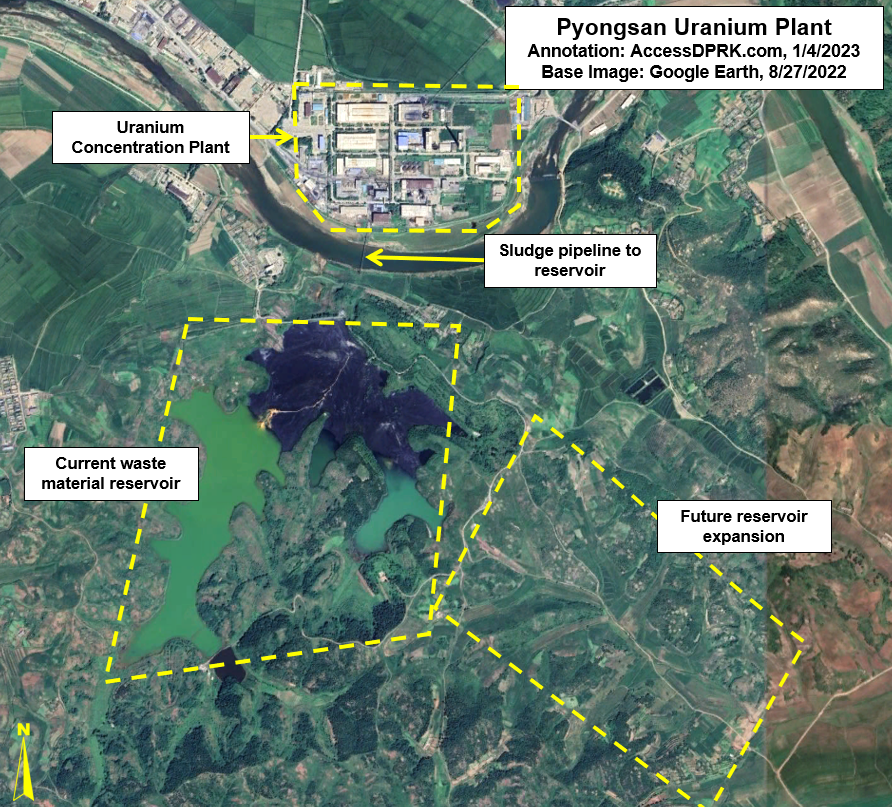
Pyongsan Uranium Mine and Concentration Plant (38°19'28.46"N 126°26'12.29"E)

According to researchers Sherzod R. Kurbanbekov, Seung Min Woo, and Sunil S. Chirayath "North Korea has at least 4 million tons of natural uranium ore reserve for industrial development, and hence total natural uranium feed available is 4,000,000kg (assuming 1000ppm ore quality). This means that the DPRK program is not constrained by the availability of natural uranium." 

That's enough for around 700 highly enriched uranium-based nuclear warheads and would supply their nuclear program for years to come.

North Korea has several large uranium deposits in Pyongsan, Pakchon, Aoji (Undok), Kumchon, and other areas. This supply comes largely from coal mines as lower quality forms of coal contain a wide range of other minerals that can include uranium.

Currently, the coal mine at Pyongsan is North Korea's primary source of uranium. The Pyongsan Uranium Concentration Plant was constructed ca. 1990 and is the only declared site that still produces "yellowcake" uranium - ore that has been concentrated to 80% uranium oxide.

The ore is transported via pipeline from the mine to the concentrate plant half a kilometer away. At the plant the ore is processed and the uranium is concentrated into yellowcake before being taken to the Yongbyon Nuclear Scientific Research Center where it is further refined into highly enriched uranium and becomes suitable for nuclear warheads.


Jongchon Graphite Mine (37°55'8.52"N 126° 6'49.64"E)

This graphite mine was established in 2003 as a joint venture with the South Korean company KORES and had an initial investment of $5.5 million. The plan envisioned an annual production of 3,000 tons and allowed each side to keep half of the graphite. The mine opened in 2006 after a total investment of $10.2 million.

The graphite at Jongchong is mined from mineral-bearing soil and gravel that is then processed to separate the graphite. The waste material is then dumped as a slurry into a holding pond.

Naturally occurring graphite can be used for vehicle lubricants, batteries, crucibles/foundries, and numerous other purposes. Graphite used in nuclear reactors is synthetic and Jongchon would not be a source for the materials needed to produce it.

At the time the mine opened, it was estimated that the annual 1,500 tons South Korea was able to acquire would be enough to provide for 20% of South Korea's domestic graphite consumption. Given North Korea's considerably smaller economy, it's possible that this one mine is capable of providing for all or nearly all of the country's needs (graphite is mined in smaller quantities at other sites).

The deal with South Korea eventually collapsed and production at the mine fell further following new rounds of sanctions. This decline can be seen in satellite images of the last few years that show water building up in the open pit mine and the surface of the waste pond drying and showing signs of agricultural activity within.

At least six other major deposits are known to exist in North Korea and in 2011 the National Defense Commission's Resources Development Corporation agreed to explore graphite deposits in three locations within South Hwanghae Province in cooperation with Chinese firms. 


Hyesan Youth Copper Mine (41°21'51.84"N 128° 9'31.68"E)

Copper is one of the most useful and indispensable elements there is. From shell casings to ships, a military can't exist without copper. 

North Korea has several copper deposits, but its largest copper mine is in Hyesan, near the border with China. Copper's utility also makes its export a prime source of foreign currency. To that end, operations at Hyesan have occasionally been carried out jointly with Chinese companies such as Wanxiang Resources Limited Company in 2007.

First explored in the 1960s, today the mining complex spans several kilometers and is estimated to have an annual capacity of 50,000-70,000 tonnes of copper concentrate. However, flooding, electricity shortages, sanctions, and COVID-19 have caused substantial problems with the mine over the years, and it has never operated at full capacity.

The construction of the nearby Samsu Hydroelectric Dam resulted in the mine being flooded in 2007 as water forced its way through fissures in the surrounding geology. The government spent $8.2 million in the first year after the flood draining and repairing the mine. 

More recently, the border closures due to COVID-19 cut off nearly all internal trade, and production at the mine plummeted. While this obviously harms North Korea's economy, limited activity at the mine continues and the extracted copper can still be used for domestic and military requirements. 


Susan Titanium Mine (38°57'52.03"N 125°21'42.77"E) 

Titanium is a lightweight and durable metal that is used in jet engines, submarines, armor plating, missile components, abrasives, and has many other uses. 

The Susan Titanium Mine in Kangso, Nampo is estimated to hold at least 20 million tons of titanium dioxide in reserves. As North Korea seeks to modernize its military and manufacture more advanced vehicles and weapon systems, having domestic titanium supplies and further developing the metallurgical technologies needed to properly exploit titanium's properties will become increasingly important.

A small mine has existed on the site since at least the 1980s, but it was enlarged and modernized in the early 2010s. As North Korea rarely releases official figure of its mining operations, activity at the mine can be tracked through monitoring the growth of its tailings reservoir. In 2011 it covered 12.2 hectares and by 2021 it had more than doubled to 25 hectares in area and was several meters deeper. 


Onjinsan Gold Region (38°49'47.48"N 126°26'49.85"E)

This is a name I've given the area surrounding Mount Onjin in North Hwanghae Province that has several gold mines within 10 km of the mountain's summit. Taken together, this is one the largest gold producing regions in North Korea, and it has some of the largest gold reserves in the world.

The two primary mines are the Holdong mining complex (38°52'8.88"N 126°27'31.21"E) and the Namjong mine (38°48'17.46"N 126°21'48.00"E). The area, Holdong in particular, has been a gold mining center since 1893 and has a capacity of at least 2 tons of pure gold a year. 

Through imagery we can tell that the mines use the cyanidation process whereby ore is soaked is cyanide which then concentrates the microscopic gold particles into a more easily recoverable form.

Although gold is used in electronics, its main value is in its ability to bring in foreign currency, enabling North Korea to fund its activities. Gold can also be very hard to trace once melted and sold into the global gold market, making it an important vehicle for illicit economic activity. 

Unlike some other minerals, gold mining falls under tighter government regulation and the military plays a role in its extraction and export. The secretive Office 39, which helps to finance everything from luxury cars to missiles, is also alleged to play a role in gold production and illegal exports.


Iron Mining

Like copper, iron is indispensable. Tanks, ships, artillery, and everything in between relies on iron and two of the largest iron mines in the country are at Musan and Unryul.

The Musan Iron Mine holds one of the largest iron reserves in east Asia with 1.5 billion tons of ore that is currently economically recoverable and least 7 billion tons in proven reserves. 

Like the rest of North Korea's mining sector, Musan has experienced the ups and downs related to economic downturns, famine, and poor economic policies, but it has remained a keystone in the country's industrial capacity and continues to provide around a million tonnes of ore each year.


Unryul Iron Mine (38°35'21.59"N 125° 8'46.47"E), also spelled Ullul, is another large iron mine. This one is located on the country's west coast 40 km northwest of the city of Sinchon. 

The large open-pit mine is 2.7 km long and overburden is taken via a 4-km long conveyor belt to the sea where, over many years, it has helped to build up sea walls for a large land reclamation project.

A port was constructed at the conveyor terminus in 2013-2014 for fishing vessels and as part of local aquaculture development. The port and associated facilities are powered by 15,700 sq. m. of solar panels and a wind turbine, making it one of the largest renewable energy sites in the country.


Tungsten

Tungsten's hardness and temperature-resistant properties give it many uses from armor-piercing rounds to use in rockets and airplanes. It can also be used in the protective shells around nuclear warheads.

Both the Man-nyon Mine (38°55'38.29"N 126°57'47.92"E) and Mandok Mine (40°36'55.88"N 128°33'45.41"E) extract wolframite, the main ore-bearing mineral for tungsten. 

Man-nyon is an underground mine with a series of mine faces that are interconnected and accessed through a tunnel system. The full area of mining activity extends across approximately 10 sq. km., with small exploratory mines spread further out.

At Mandok, iron is also extracted. Water runoff from the mines is stained with the oxidized metal, noticeably staining the rivers a rusty color for over 20 kilometers.

The United States Geological Survey estimated that North Korea produced 1,410 tonnes of tungsten concentrate in 2018. At 65% purity, that would yield 916 tonnes of elemental tungsten - placing North Korea in the top 10 producing countries globally. This is considerably more than 2014-16, when only 70 tonnes was estimated to have been produced each year. The reason for such a dramatic increase is not explained in the report.


Komdok Mining Region

Location of magnesite related facilities. Image from "Mining North Korea: Magnesite Production at Ryongyang Mine" by Joseph Bermudez and Victor Cha. Center for Strategic and International Studies, August 16, 2019. Used with permission.

Komdok is one of the largest mining regions in North Korea and produces everything from magnesite to lead to zinc to cobalt - cobalt being used in temperature-resistant alloys, stealth technology, and ammunition. 

The region holds one of the largest magnesite deposits in the world, with an estimate 2.3 billion tonnes in reserve. Magnesite can be alloyed with other metals for a range of products including aircraft parts, rocket nozzles, optics, and batteries.

The dozen or so mines in the Puktae River valley which runs through the Komdok region are also sources of lead, zinc, cobalt, and small amounts of other minerals necessary to the defense industry.

Typhoon Maysak in 2020 hit the area and caused substantial flooding. In response, Kim Jong Un ordered that 2,300 housing units be immediately constructed and that the transportation network be upgraded to facilitate future investments in the region.

Calling Komdok a "major artery of the national economy", Kim outlined his second phase for the area in order to build it into "the world's best mining city". This attention underscores Komdok's strategic importance. 


March 5 Youth Mine (41°42'19.97"N 126°49'10.99"E)

Molybdenum is used in the production of 80% of the world's steel and forms strong carbide alloys making it a needed element for creating high-temperature metals and 'superalloys'. It is used in the aerospace industry, missiles, and metal armors. 

At least three mines are known to produce molybdenum but the March 5 Youth Mine in the village of Hoha-ri has North Korea's newest molybdenum ore processing facility and it was visited by Kim Jong Il.

According to Radio Free Asia, North Korea has been stockpiling mined molybdenum in anticipation of resumed trade with China and in the hopes that molybdenum prices will have spiked by then. One organization involved in North Korea's molybdenum trade is the military-affiliated trading company Kangsung. 


I would like to thank my current Patreon supporters: Alex Kleinman, Amanda Oh, Donald Pierce, GreatPoppo, Henry Popkes, Joel Parish, John Pike, Kbechs87, Russ Johnson, Squadfan, and ZS.

--Jacob Bogle, 10/23/2022

Saturday, September 24, 2022

In North Korea Thousands of Guns Point to the Sky

North Korea has the densest network of air defense sites in the world, and their mix of low-level anti-aircraft artillery (AAA) systems, Soviet-era surface-to-air missile (SAM) bases, and early warning radars still pose a risk to adversaries. 

An M-1983 Quad 14.5 mm anti-aircraft gun being shown during a parade in this undated image.

Between the AAA and SAM batteries, over 1,500 fixed air-defense sites are arrayed to protect North Korean airspace (squeezed into an area half the size of England). 

In this article I will focus on the current capabilities of the county's anti-aircraft artillery, but I'll also touch on their surface-to-air missiles as well.

Under the control of the KPA Air Defense Command and Pyongyang Antiaircraft Artillery Command, North Korea's AAA defense are made up of M-1983 Quad 14.5 mm guns, ZU-23-2 twin barrel autocannons, M-1992 Twin 30 mm autocannons, and M-1992 Twin 37 mm self-propelled guns.

These guns have a practical rate of fire of between 150 and 1,600 rounds per minute per barrel, with effective ranges of 2.5 to 5.8 km depending on which system is being used. 

AAA batteries are typically laid out in two arrangements, the "daisy" and what I call the "I".

Example of the "daisy" layout.

Daisy arrangements refer to a circular configuration of guns. They range in size from 4 to 12 guns and may form a "chain" of daisies, with 2-3 sets of four guns each or they may simply be a single circle of guns. 

According to George Herbert, adjunct professor at the James Martin Center for Nonproliferation Studies, AAA guns in this arrangement lie within a targeted environment (such as near the Yongbyon Nuclear Center) and can protect it from threats coming in from any direction.

Example of the "I" layout.

The second primary arrangement for AAA guns is "I". These are just a single straight line of guns. All but one of the "I" layout sites deploy 8 guns.

Mr. Herbert explains that this arrangement is best for firing at aircraft that still lie outside of the main target, such as on the approaches to Pyongyang, but before they actually enter the city's airspace, and can concentrate the fire from multiple guns onto the enemy aircraft.

There are 70 of these surrounding Pyongyang in an oval ring 25-30 km outside of downtown.


A Layered Defense

The country's air defense is constructed using a layered approach. The DMZ and each coast has a line of AAA batteries along them with the main coastal cities then being encircled by their own ring of defenses. Interspersed in other parts of the country are the batteries for major KPA bases, navy and air bases, missile sites, industrial centers, and key palaces. There are also a few others scattered around the country at seemingly random sites. 

Nowhere is this layered defense more obvious than at Pyongyang.

As the nation's capital city, Pyongyang is the largest population center, is where all of the main military command centers are located, and it contains the greatest concentration of industry making its capture a primary goal in any war.

Pyongyang has over 400 AAA batteries arrayed in three main lines of defense, and it is also protected by two outer rings of 19 surface-to-air missile batteries as well.

Illustrative map of the main AAA and SAM defensive ranges (approximate distances) around Pyongyang, with the Ryongsong Palace highlighted in blue. The yellow ring is the palace's dedicated air defense ring.

Within Pyongyang is also the Ryongsong Palace complex. Nestled within Pyongyang's air defense space, the palace is surrounded by its own dedicated ring of AAA batteries and is covered by at least 5 nearby SAM batteries, making the palace perhaps the most well-defended single site in the world.

Other areas that enjoy substantial air defense are Nampo, Sariwon, the Yongbyon Scientific Nuclear Research Center, Haeju, Kaesong, Wonsan (which is also home to a Kim palace), Hamhung, Kanggye, Chongjin, Tokchon, and the elite Samjiyon-Mt. Paektu area.


All of these overlapping clusters also end up creating a thicket of AAA sites within the "Kaesong-Munsan" invasion corridor. This would be the most contested stretch of airspace as it is the most direct path from connecting the capitals of North and South Korea. The corridor is roughly 50 km wide and 155 km long, stretching from the DMZ up to Pyongyang. 

Map of invasion routes including the two Kaesong approaches. Image: Marine Corps Intelligence Activity, North Korea Country Handbook, May 1997.

In any given 5 km circle (the maximum range of most AAA guns) a pilot would only have three, perhaps four, brief moments where they weren't in range of any guns if they were flying through the center of the corridor. Of course, where AAA may not reach there are still the dozen+ SAM sites that lie within the corridor and whose ranges are between 25 and 300 km depending on the missile system being used.


Point to the Sky

Nationwide, North Korea currently has 1,463 active AAA sites. These batteries have the capacity to field 8,641 individual artillery pieces. Each battery consists of anywhere between a single gun to up to 12 guns. The majority fall in the 6-8 gun range. Not every fixed position has a gun in it at all times, but around 90% do. This means that at any given moment there are 7,777 artillery pieces ready to fire.

There are also 521 known decommissioned sites. Having decommissioned sites mapped is important, particularly within the public sphere, in order to have accurate maps available. Many of these older sites haven't been demolished, merely closed, and so they still look like they could be used. That has led to some of them being incorrectly identified as active on other databases (like OpenStreetMap and Wikimapia).

Additionally, knowing when sites are closed or newly constructed allows researchers to better track trends in air defense strategies (among other things).


Surface-to-Air Missiles

Map of current SAM positions.

The country also maintains between 57 and 61 surface-to-air missile batteries, with two of them being modern constructions. Most field S-25, S-75, and S-125 systems that are from the Soviet-era. North Korea has attempted to develop their own SAM systems with the KN-06 and KN-30 which are clones of Russian S-300 and S-400 SAMs. However, despite being promoted in official state media, these mobile systems haven't yet been verified to have been fully deployed through open-source imagery and publications.

If they are being used, they would most likely first be sent to the new SAM batteries constructed at Wonsan (39° 7'16.21"N 127°44'16.26"E) and near the town of Haeju (38° 5'28.79"N 125°27'2.18"E).

Between AAA and SAM sites, approximately 75% of all of North Korea's airspace is covered using conservative measurements. The largest gaps in coverage are in the highly mountainous border areas with China and access to those gaps would require either flying in from China or making it through already defended areas.


An updated explorable map of North Korea's air defense sites is available through purchase of the AccessDPRK Map (Pro Version)


I would like to thank my current Patreon supporters: Amanda O., GreatPoppo, Joel Parish, John Pike, Kbechs87, Russ Johnson, Squadfan, and ZS. 

--Jacob Bogle, 9/23/2022