Sunday, June 20, 2021

The Unique Buildings of North Korea's Missile Program

Despite all of the things we see and learn during North Korea's military parades and missile tests, only a fraction of the real story gets told (and often a fair amount of obfuscation is mixed in as well). Public knowledge of their ballistic missile program is still extremely limited though new discoveries do come to light.

Not every missile or vehicle is openly shown, and there are many deployed weapons systems and other equipment that have never been disclosed. Likewise, the infrastructure and training programs for their Strategic Rocket Force is largely unknown. And, North Korea has a habit of doing things just unusual enough as to baffle experts around the world.

In comparison to the United States and Russia/USSR, they test rockets and fire missiles far less often before beginning to mass produce them and place them into service. Their ability to indigenously manufacture the vehicles needed to transport and launch their missiles (especially the more modern versions) has often been viewed as lacking, but somehow, they end up with the equipment they need. Sometimes this is accomplished by converting large trucks from China and elsewhere, but it seems that their domestic capabilities may now surpass the limited capabilities usually described in public intelligence reports. 

Though this exact process is not fully understood, as WMD expert Melissa Hanham remarked in regard to the 11-axle transporter erector launcher (TEL) seen during the Workers' Party 75th anniversary parade in 2020, "It is also clear that they have built up their manufacturing sector to indigenously modify - and now potentially produce - their own missile launchers."

So, we are often left to dissect photos from state media, parse through the vague language of government and military officials, and use commercial satellite images to look for clues and try to learn what the DPRK doesn't want us to. That’s the purpose of this article, to use what is available to try and paint in some of the picture regarding North Korea’s TEL development.

Locations of the five extant TEL-cupola facilities.

One such little-known cog within North Korea's vast missile infrastructure are five (formerly six) unusual buildings that have been described as "clearstory cupolas". Their exact nature is not known, at least not publicly, but it is surmised that they play a role in both the development of new TEL designs and a role in the maintenance of deployed TELs, and in training their Strategic Rocket Force.

They take on two main designs, one is a modified section of roof of a larger, high-bay building and the other is a small building that is basically the modified roof section itself but placed on the ground as its own independent structure. 

The most well-known of these little-discussed structures is the Jonchon TEL Assembly Plant that was written about in 38 North's "That Ain't My Truck", in which the authors hunt down the location of this special building after it was first shown in a state propaganda film. 

Of the inventory of these formerly six (now five) buildings, two are located at known TEL/arms assembly factories, one was located at a missile-related facility, and three were built after 2011 at known missile operating bases stationing short range- and medium range- ballistic missiles.

The city of Jonchon has two of these facilities. The first is what was shown in the 2013 Korean Central TV program and discussed by 38 North. It is located at 40.645677° 126.432921°.

In 2004 the cupola structure was approx. 11 meters long by 6 meters wide.


By 2011 the cupola structure had been enlarged to ~20 meters long and 6-7 meters wide. Exact measurements can be difficult to acquire using Google Earth.

The following are models of the Jonchon TEL Facility.

Building model by Melissa Hanham, James Martin Center for Nonproliferation Studies. Used with permission.

This interior view shows not only the cupola but a KN-08 TEL with missile raised. Missile and TEL model by Frank Pabian and Tamara Patton; building model by Melissa Hanham, James Martin Center for Nonproliferation Studies. Used with permission.

The other Jonchon facility is locate a short 3.7 km south at the Mupyong-ni Arms Plant (40.612031° 126.426428°). 

In 2004, the cupola was 15 meters long.

As with the TEL assembly plant, the cupola was enlarged here, too. It was expanded to 20 m in length (also increasing its height), making it capable of handling newer, larger generations of missiles.

The Mupyong-ni Arms Plant was the site of a 2017 test of the Hwasong-14 ICBM. A monument was erected at the plant to commemorate the launch.

The other sites are as follows:

Sakkanmol Missile Base (38.582871° 126.082998°). Unlike the two in Jonchon, the Sakkanmol facility is a stand-alone cupola structure, not attached to any larger building. It was constructed sometime between 2011 and 2013. 

The simply built structure is 16-17 m long by 7.5-8 m wide.

Sakkanmol is home to MAZ-543 TELs which carries the Hwasong-5 short-range ballistic missile, and the base is capable of deploying the Hwasong-6 and could be modernized to accommodate larger missiles. According to Beyond Parallel, the base has 9 to 18 TELs/MELs stationed at it.


Kal-gol Missile Base (38.684702° 126.720857°).


Kal-gol's cupola building was constructed in 2012. It consists of a 31 m long building with a cupola structure that is 14.5 m long by 3 m wide. Like Sakkanmol, it is a short-, medium-range ballistic missile base and has the Hwasong-6 and Hwasong-9 missiles deployed there.

Beyond Parallel's 2020 report on the base noted the existence of the clearstory cupola facility and supports the idea that they are used for TEL/MEL maintenance and training purposes.

The report also stated that the arched clearstory, "reaches a height of approximately 13-15 meters. This height allows for the elevation of a Hwasong-5/-6 missile (and potentially the 13.5-meter-long Hwasong-9 (Scud-ER) depending upon the level of the floor) on a TEL or MEL for both training (especially during the harsh winter months) and maintenance. The latter would ease the burden of depot-level maintenance requiring a TEL or MEL having to be sent back to the factory for repairs or upgrades and reduces the length of time that a launcher is away from its parent unit. However, this clearstory building is too small for larger missile systems such as the Hwasong-12, -14, and -15."


The last existing facility is at the Kumchon-ni missile base (38.964928° 127.597185°).


The TEL building at Kumchon-ni was constructed in mid-to-late 2012 and is 18-19 m long by 8-9 m wide. A set of adjacent barracks were joined into a single building at the same time. Unlike the other TEL structures, this one was built against a hillside, where the others are in more open terrain. 

However, like Sakkanmol and Kal-gol, Kumchon-ni is within the "tactical belt" of North Korea's ballistic missile base network. These bases house short- and medium-range ballistic missiles and would be involved in any first-strike against South Korea or even parts of Japan, as well as targeting US forces within South Korea. They would also be among the first locations to be attacked, and so ensuring proper training and that operational readiness is maintained is of the utmost importance. 

Generally, these buildings are large enough to accommodate TELs/MELs for the KN-02, KN-23, KN-24, KN-25, Hwasong-5, -6, -7, and -9, and possibly the Hwasong-10 and Pukkuksong-2. (See also: Missiles of North Korea by CSIS)


A sixth facility used to exist until it was demolished in 2020. Located much farther north than the missile operating bases mentioned, near the town of Sinhung, is a missile-related complex at 40.260594° 127.490231°.

The structure was 9-10 m wide and 20 m long.

Abutting a hillside, the Sinhung TEL structure was demolished ca. Feb. 2020.

Only an empty foundation remains today. However, at roughly the same time that the site was being demolished, another building was being constructed about 1.1 km west.


This new building is ~67 m long by 17 m wide and has a large hole in the roof that's 25 m long by 5 m wide. This could be a new larger cupola facility under construction, like the two in Jonchon, and would be used to develop larger TELs, as the opening for the clearstory section is bigger than at either Jonchon facility. Of course, only updated imagery of the completed building will give any certainty to this, but it does seem coincidental and the fact the unfinished building has a specific shaped hole in the roof suggests that this could be the case.


As we have seen, these facilities were either enlarged or built in and around 2011/2012, this coincides with Kim Jong Un's orders after assuming power that realistic training be instituted and operational readiness improved. The development of future (post-2011) generations and variations of ballistic missiles was also high on Kim Jong Un's agenda. This desire may be reflected in the proliferation of these structures as well - to facilitate newer systems as they are tested and their deployability ascertained.

Having a multi-purpose building such as these, where one can maintain various equipment, train on their use, and even modify them on the fly, would be greatly valuable to a cash-strapped country. These facilities, in combination with other purpose-built training facilities, lets us know that North Korea is serious about creating an effective missile force with the means to launch from any point in the country while maintaining the usefulness/survivability of their TELs.

Lastly, the particular nature and design of these clearstory cupola structures appear to make them unique to North Korea, as other experts have told me they weren't aware of any other country using buildings with this design in their missile programs.

It will take more research before their full purpose is known and how they interconnect with the rest of Pyongyang's missile program is understood, but at least we have a baseline of observations showing their locations, times of construction, and other important information that helps to build the picture.


I would like to thank my current Patreon supporters: Amanda O., GreatPoppo, Joel Parish, John Pike, Kbechs87, Planefag, Russ Johnson, and ZS.

--Jacob Bogle, 6/19/2021

Friday, May 14, 2021

"Border Blockade" - DPRK Clamps Down Like Never Before

North Korea has always been a relatively closed country, and casual international travel has never been an option for the population. Thus, the state has taken numerous measures to close off their border with China to prevent illegal trade, defections, and to limit the spread of outside information.

In this undated image, guards maintain a section of border fence along the Yalu River. (Source

Major events have led to the breakdown of this system as local soldiers and police became susceptible to bribes and internal pressures meant citizens were emboldened to cross the border to earn a livelihood (and a relative few to escape). One such event was the famine of 1994-98. During this time Kim Jong Il attempted to tighten border controls and drastically limit internal travel as well. One of these projects was a national fence system that integrated border security with cutting access to the sea, to prevent illegal fishing and defections via boat.

Kim Jong Un reinvigorated these measures and has been very successful in cutting down the number of defectors; although, less successful at stopping illegal trade. He has also renovated poorly maintained sections of the coastal fence.

The biggest changes, however, have taken place at the Chinese border. Extra guard posts, cameras, signal jammers and other technologies to track and interfere with cross-border communications have all been added. Those, along with enhanced punishments for police and border guards who allow themselves to be bribed, have cut defections down to the lowest levels since before the famine.

However, the latest attempts to control the Sino-DPRK border go well beyond anything we have seen before. The intersection of the government's desire to gain greater control over market activity by limiting illicit trade and its perceived need to hermetically seal the country away from the world to keep COVID-19 from ravaging the nation, has led to border cities practically being turned into their own prisons. 

As first described by AllSource Analysis, cities like Hoeryong have had a double layer of (likely electrified) fencing added, the number of guard posts has dramatically increased, and even farmers must now pass through checkpoints in order to access their fields near the border. 

Up and down the Sino-DPRK border, these additions that have collectively been referred to as a "border blockade"can be verified through commercial satellite imagery.


The city of Wiwon (40.892144° 125.965411°) is one such county seat where new fencing and guard posts can easily be seen.

Fencing does not run the full length of the border. In many places, like Wiwon, dams create wide and deep reservoirs along the Yalu River and the outflow of the dams mean that the river doesn't freeze over in winter - preventing an easy walk across. Additionally at Wiwon, there is no riverfront road. The only road leads south, away from the border. Thus, the only way to get away from the active patrols of police in the city is to walk through forests and mountains in the hopes of finding a better spot to cross. 

These natural obstacles are no longer deemed sufficient. In late 2020, the poorly maintained partial fence that had existed was rebuilt and extended across the whole town's riverfront area.

The old partial fence at Wiwon.

The old fencing was repaired and new fencing added, cutting off access to a stream and preventing people from walking across a dirt road to reach the Yalu River. The Wiwon fence now runs for 1.5 km, anchored by the impassible Wiwon Dam and mountains to the south.

Added border controls have also popped up in much more rural areas, like at the villages of Kosan-ni and Phosang, 20 km upriver from Wiwon.

The blue line marks out the original border fence that has been renovated. The black line marks out the new, secondary fence that was only recently constructed. The number of guard posts were also dramatically increased.

To access the land in between the two fences, farmers must now pass through checkpoints. The new fence is not yet complete and new sections and guard sites are being built. The largest chunk of land in this one area cut off from easy farming is approximately 126 hectares (311 acres). While this doesn't prevent the land from being farmed, it does make the process even more difficult and makes it harder for the lowest class of citizen to engage in trading activities.


The regime has even added security in cities where security and surveillance is already strong. Manpo is a border city with an official border crossing. It is also home to important chemical and industrial facilities which necessitate higher security on their own. 

Manpo has a levee to protect it from a flooding Yalu and has border guard posts built on top. There are also guards and police deployed along the border crossing and in the hills that encircle the city. Regardless of these controls, a second fence line was added just a few meters behind the already secured levee. 


The cities of Yusong and Hoeryong, which lie on the Tumen River, have been fenced off together to form a single security area. 


There have been 14 km of new fencing built connecting the cities. The new fence ties into the main line of border fence at each end which are then anchored by hills next to Yusong and Hoeryong, preventing people from crossing the Tumen in this area.

The new fence here also follows the path of the railway, something it does in other areas as well. This provides the added security effect of keeping people from being able to jump on or off trains in an attempt to circumvent internal security checkpoints and train stations, where travel documents must be examined.


In 2018, the AccessDPRK database only had eleven identified guard posts along this same area; roughly one for every 1.2 km. With these new changes, including additional posts on the first fence and the ones associated with the second fence, there are posts every 60-100 meters with some as close together as 40 meters. For both fences combined, that's anywhere from 280 guard posts (one for every 100 m) to 466 (if one for every 60 m).

There have been DailyNK reports that even the regular army has been brought into some of these areas to help build the fencing and man its positions. However, I do not think that every single guard post will permanently remain manned. I think they will serve more as a deterrent, as any one could have an armed soldier in it and the locals won't know which ones do or don't at any given time.

If I can interject some personal feelings, I find the additional fencing and guard posts at Yusong and Hoeryong even more tragic, as this area has been the victim of two major floods in just five years. The sense of helplessness among the people at seeing the new construction - that they can't leave a very dangerous area or stock up on traded goods in the event of another disaster - must have been palpable.


Pyongyang may be determined to put an end to defections (something they're very close to doing) and they are desperate to prevent the spread of COVID-19, the country is equally desperate to resume importing goods from China. COVID-19 has wrecked the national economy and it has been speculated that the government is nearly out of foreign currency reserves. It may be a tight rope walk between the tasks of border security, public health, and trade, but it is journey they must navigate. To that end, while coinciding with these stricter border controls, the preparations to resume limited trading seems to be underway.

Activity between the Dandong and Sinuiju customs areas has picked up and the nearby military airport at Uiju is apparently being turned into a disinfection center to handle goods and human traffic. 

Even a socialist paradise can't live off of autarky alone.


I would like to thank my current Patreon supporters: Amanda O., GreatPoppo, Joel Parish, John Pike, Kbechs87, Planefag, Russ Johnson, and ZS.

--Jacob Bogle, 5/13/2021

Wednesday, April 21, 2021

Daily Life in NK via Satellite

North Korea is more than nuclear weapons and it's more than the caricature of a fat dictator and robotic people with no real lives. Their lives are also more than the often scripted and saccharine scenes shown in official media - as though the people are then placed in a box and vanish until needed again.

People planting trees for Arbor Day 2021. Korean Central News Agency.

North Korea is a dynamic country with 25 million unique human beings. Yes, it is a totalitarian state with a terrible human rights record, but those 25 million people still work every day to live their life, go to work and to the markets, go to school, and do the things we all do in pursuit of the opportunities available.

Especially since the country has become even more closed off due to COVID-19, it can be difficult to see examples of everyday life in North Korea. However, satellite imagery gives us the ability to observe a myriad of activities across the nation that would normally be off-limits to tourists or are currently not within reach.


Play Ball!

Like the rest of the non-US-centric world, football means soccer in North Korea, and it's a fairly popular game. The national team has qualified for multiple FIFA World Cup, Asian Games, AFC Asian Cup, AFC Challenge Cup, East Asia Cup, and Dynasty Cup competitions. They've won a total of 138 games including a Gold Medal at the 1978 Asian Games.

Sobaeksu (a subsidiary team of the national 4.25 Team) being coached in Pyongyang. Used with permission: James Montague, Sept. 2017.

As a result, every county seat has a stadium and many grade schools, universities, and military bases have soccer fields. Pyongyang has an enormous athletics infrastructure with at least 58 stadiums and dedicated soccer fields.

In the important military town of Sinpo, a soccer game can be seen underway on this image dated May 7, 2016. I estimate that there's at least 1,500 spectators. 


Museum Trip

The Susan-ri House of Class Education is a special type of museum in North Korea that chronicles alleged human rights abuses and war crimes by the United States during the Korean War and acts as an indoctrination vehicle for anti-US/ROK ideology. 

Although the purpose of the museum is unique to North Korea, it's still similar to other museums around the world where school classes are taken on trips as well as worker's union groups and others, making these museums part of the normal life experience for the people.

This specific museum was one of the first to be rebuilt and modernized in 2010; a process that continues nationally to this day. On Jan. 14, 2015, a large crowd can be seen waiting to go inside the museum and explore the museum grounds (which includes an alleged mass grave of "victims" of American atrocities). A number of buses are also visible in the parking lot.

There may or may not be a connection, but on Jan. 10, 2015, North Korea offered to suspend nuclear testing in return for the US and South Korea not holding their annual joint-military drills. The offer was rejected. So, the regime may have decided to increase the amount of anti-US propaganda as a result, including ramping up visits to the museum. (Mere speculation on my part.)


Kim & Friends Visit Palace

Two bodyguards stand at attention at the door to Kim Jong Un's armored green train. Photo: The Government of Primorsky Krai, April 26, 2019.

Kim Jong Un spent a lot of his childhood at the family's summer palace in Wonsan. The beachfront property has white sand beaches, wooded hills, and several expensive yachts and party boats. 

The main way to travel from Pyongyang to the palace is via a massive, green train. The use of an armored train dates back to Kim Il Sung and it has become to primary mode of transportation for each generation of Kim as it is basically an "Air Force One" on tracks.

Kim's train seen via Google Earth at the Wonsan palace train station on Nov. 28, 2018.

At its longest, the train is 21 cars in length, each one 23-meters long, giving the train a total length of over 500 meters (when you include the spaces between cars); although, for most domestic travel the train is only about half that length.

Tracking down the train's movements via commercial satellite imagery became one way to dispel rumors of Kim Jong Un's alleged death in April 2020 after he went missing for a few weeks. 38 North managed to find the train at the Wonsan Palace on two occasions around this time, and imagery obtained by others showed at least one of Kim's pleasure boats out on the water. While this didn't confirm Kim was alive, it was part of a growing body of evidence that he was indeed alive and at the palace, even if in bad health. 

He eventually reappeared in public on May 1 at the opening of the Sunchon Fertilizer Plant. 


Monumental Missile

2017 was a banner year for North Korea's missile program as they successfully tested their Pukkuksong-2 medium-range intercontinental ballistic missile, and Hwasong-12 & Hwasong-15 intercontinental ballistic missiles. The Nov. 28th Hwasong-15 test revealed that it could theoretically reach all of the United States.

As a result, the regime erected monuments at several of the launch sites. The largest of the monuments was dedicated to the Nov. 28th test of the Hwasong-15. The monument includes the concrete launch pad (right side) and a stone monument (left) giving a description of the test, its importance, and the fact that it was personally overseen by Kim Jong Un. It also has a parking area across the road.

In this image from August 31, 2018, a crowd of people can be seen walking from the launch pad to the stone monument. Visiting monuments and historic sites on special holidays or as part of "field trips" (for both kids and adults) is an everyday kind of thing in the DPRK.
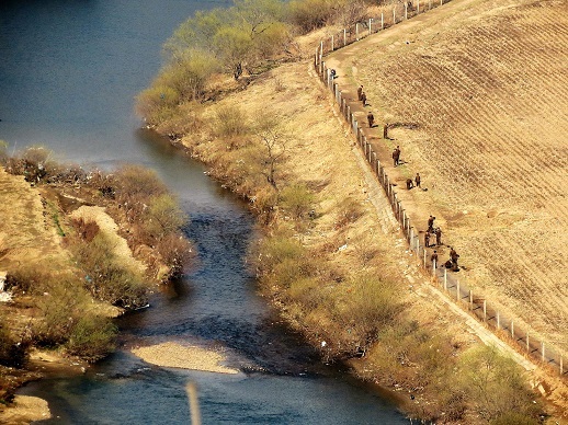

Dredging for Gold

Most of the rivers in North Korea are not navigable. The upper reaches of the Kuryong River is no different. For many years dredging has been going on in the river. Since the river isn't navigable in the first place, the dredging isn't to improve shipping navigation.

However, along this portion of river is the Unsan Gold Mine. In operation since at least 1895, the mine has been one of Korea's (and later North Korea's) major sources of gold. 

Gold is heavy and gets eroded out of the original mineral deposits and eventually washed down river, where it's deposited in the riverbed and along the riverbanks. In the early 1990s, the country was mining around 4 tonnes of alluvial gold - gold found in riverbeds and other sediment. At today's gold prices, 4 tonnes is worth $227.6 million. 

How much gold currently comes from the Kuryong riverbed is unknown, but continuous signs of dredging operations (with multiple dredges) can be tracked for 40 km and began ca. 2003.

Unfortunately, there are several down-sides to this type of mining. For one, it destroys the habitats in the immediate area. Secondly, the process creates a lot of particulate pollution, as the sand and silt is disturbed and flows downstream. This can cause lower amounts of oxygen in the water and kill most species (including the amphibians that live along the banks). 

Finally, depending on the method used, once the gold-bearing material is gathered, the process to extract the pure gold can involve using mercury and other chemicals that leak into water systems and can cause severe health problems for the miners.


Plane Overhead

At any given time, there are up to 5,000 planes flying around the world. This makes finding a plane in flight on Google Earth something that isn't common, but not exactly rare. Back in 2005 there was even a GE user who put together a KMZ with 75 examples of planes in flight. I've found a few dozen more over the years. 

North Korea is a different story. Prior to COVID-19, there were only a few dozen non-military flights a month into, out of, and within the country. And even military training flights are restricted due to a lack of aviation fuel. With COVID-19, there might be just one or two flights a month to shuttle VIPs around.

So this little find is far more unusual than finding planes coming into London or Beijing. 


This image shows an An-2 flying so low to the ground that its shadow can be seen. The difficulty in seeing the plane itself could be due to image quality, but it could also be because the plane itself may be camouflaged. 

An-2's are simple biplanes that were built decades ago by the Soviet Union. North Korea has a fleet of hundreds of them and due to their small size and ability to fly low, they're actually a key part of North Korea's air force. They are intended to be used as surveillance and infiltration aircraft, smuggling special operations forces into South Korean territory - under the detection of most radar systems - so that they can destroy important targets.

In recent years North Korea has been changing the plane's color schemes to make them less visible in the air, and they have been working to improve the capabilities of their special forces.

This particular An-2 is flying around the Kuktong Airfield, which happens to house two An-2 squadrons, and is also just 21 km away from the Orang Airbase, home to the 8th Air Training Division.


Coniferous Gas


Although there is apparently more gasoline available than generally thought, there is still nowhere near enough to meet the country's fuel needs.

To help bridge this gap, mostly in rural areas, North Korea has converted many of its trucks and tractors to run off wood gas, a fuel made by burning wood or charcoal at relatively low temperatures and then processing the material onboard to produce fuel the vehicle can run on. 

North Korean truck with a wood gasifier producing white smoke. Photo: Raymond K. Cunningham, Jr./CC BY-SA 3.0

Unfortunately, while wood gasification allows thousands of trucks, tractors, and even motorcycles to operate in the country, the process and equipment used in North Korea is very dirty and inefficient.

The gasifiers send out large plumes of thick smoke. Only a small amount of fuel can be produced at any given time, so if it breaks down, the vehicle will stop running. And, it requires drivers to practically be mechanics to operate and maintain the equipment, especially as most of the vehicles on North Korea's roadways are already decades old and require their own maintenance. 


Waiting on the River Ferry

While most transportation is carried out by trucks, buses, and trains, North Korea does have a few river crossings that are serviced by passenger & cargo ferries. 

Unlike the large ferries that can carry people and cars to their destinations around New York Harbor, these ferries can only carry one or two dozen people along with small amounts of cargo. This ferry on the Changja River is important because the nearest bridge crossing is 10 km away (making it a 20 km journey to the other side of the river by car, and then 20 km back).

For a population with limited car ownership and bad roads, ferry crossings become an important piece of daily life for many in rural areas.


Kim Il Sung's Birthday

In the city of Kaechon, the above image shows people doing traditional folk dances in preparation for Kim Il Sung's 107th birthday on April 15. Kim's birthday is known as the "Day of the Sun" and it is one of, if not the most important national holidays in North Korea.

People are given time off work and school, the state gives small gifts to the population, and people are required to visit important local monuments dedicated to Kim Il Sung, and to take part in "spontaneous" celebrations.

While these celebrations are, of course, planned and practiced for, people receive an additional two days off after the main holiday date, and so get to have some relaxation and family time.

Having mass birthday celebrations for a man who died a generation ago may seem odd to most, but the importance of the holiday is considered the North Korean equivalent of Christmas in importance. (Note: the actual holiday of Christmas is not observed in North Korea. Instead, the winter solstice is celebrated on Dec. 20 and the birthday of Kim Jong Il's mother is celebrated on Dec. 24.) 

Similar group dancing to that seen in the satellite image. This time (April 9, 2013) it was to celebrate the 20th anniversary of Kim Jong Il becoming Chairman of the National Defense Commission, making him the de facto leader of the DPRK military. 


Going to Class


At the Hamhung University of Agriculture, you can see students milling about the yard and a small group of them gathered near the center. This image is from March 22, 2011, but there are several images over the years showing various gatherings at this university.

While one can't tell why the students have gathered based on this image, it could be a class going in together, a new class being given a tour, or even a group preparing for a form of calisthenics. 

Similar outdoor assemblies can be seen at grade schools and universities throughout the country.


Collective Agriculture

While there are farmers and other agricultural workers, due to the country's lack of equipment, the vast majority of the population lends a hand (rather, they're drafted) to do farm work for certain periods of the year - namely, during planting and harvesting. Soldiers, students, and factory workers all work to ensure that the country can provide as much food as possible each season.

One very obvious example of this that can be seen via satellite is after certain crops have been harvested. In this case, corn. The harvested golden ears are then placed in open spaces to be dried by the sun.

How food is distributed in North Korea can get complicated. There's the regular state-owned cooperative farms. There's farms control by the military. And, there's smaller plots of land that factories and schools use to try to supplement their food supply or sell in the markets.

The result of that complicated network gives us this image: corn drying at the Kim Jong Il Postgraduate Military Institute.

NK News published an article detailing the corn drying operation at other sites around Pyongyang in 2020.


Pioneering Parades

North Korea is very well-known for its huge parades and mass events. While the media typically focuses on military parades, the country holds other types. 

Being in a parade or other mass event may not be an everyday activity, but training for them and then participating in the main event is still common enough. These events can involve tens of thousands of people and can require over a month of training. This means that most citizens have taken part (as a "performer") in some form of mass gathering in their hometown or county seat at least once, and likely multiple times. 

As part of the 10th Congress of the Kimilsungist-Kimjongilist Youth League (the country's main youth organization), participants threw a parade. Satellite imagery revealed preparations in March for the Youth League meeting in April.

Like all of these large parades, the participants used their bodies to spell out words, make shapes, and do other cool things reminiscent of marching band competitions. 

On this March 9, 2021 image, participants are in the process of spelling out "pioneer". That is most likely a reference to the Young Pioneer Corps which is for children under the age of 15.


I would like to thank my current Patreon supporters: Amanda O., GreatPoppo, Joel Parish, John Pike, Kbechs87, Planefag, Russ Johnson, and ZS.

--Jacob Bogle, 4/20/2021

Sunday, March 28, 2021

What's Inside North Korea?


This is a breakdown of North Korea by the numbers based on the AccessDPRK 2021 Map, Pro Version. This is similar to the North Korea by the Numbers post I made for the 2017 map.

Since I want to give a full accounting of all of the different places that are in the country, I am basing this off of the Pro map, which has thousands more places than the free version


My interest in North Korea began in late 2012, then I found some older maps others had done and decided to make a truly comprehensive version, as all of the others were either severely lacking or only focused on one sector (like Planman's great work on air defense sites). I started the blog in 2013 and released an early version of the work in 2016. Then came the first "full" map in 2017 and finally the 2021 map, which will be the last comprehensive nationwide map of the country I plan to make. 

As all of my maps have been divided into monuments, military, and domestic sites, I'll give their overall numbers first.

The project has located 11,661 extant monuments in North Korea. There's 13,566 military sites (manned, unmanned, and former). And there's 39,407 domestic sites marked. This represents a 18.1% increase from the 2017 map; however, the military folder is actually over 41% larger than the 2017 military folder. That's 64,634 sites.


The provincial breakdown for the monuments is:


In 2019 I published an initial survey of the country's monuments. The total figures have grown slightly since then, but the article also talks about other monument-related things and is worth checking out.

Compared to 2017, thanks to improved imagery and new construction, there are 1,765 more monuments located. The Pro version also includes the dates many were constructed, and from that we can now know that at least 623 monuments, murals, and bronze statues have been installed under Kim Jong Un. 

There are also three sites in Pyongyang that are prepared for future statues, but the statues have not been erected yet. 


The military folder of the 2021 Pro Map is over 41% larger than the 2017 military folder. This isn't because I missed a bunch of places, but it's due to the fact that I wanted to give an even more granular look at the country's military, trends, and changes over time. This means I focused on mapping even former facilities, located the storage sites within military bases, paid special attention to locating tunnels and underground sites that may have been well hidden, and marked important bases (like missile sites) with greater detail. The change is also due to improvements in available imagery, making it possible to discover things that were previously too blurry to be identifiable. 

A few of the specific improved numbers are: 110 additional observation posts along the DMZ (at least 18 were built after 2015), 44 additional radar facilities, 67 more AAA sites (15 were built from 2015-2019), and over 400 additional verified military bases. Then there's the 126 hardened artillery sites that have been constructed since 2010. However, one of the largest increases comes from the storage facilities (stand-alone and within other bases) that I gave more attention to for 2021. The map includes 1,337 of them. That's a further 650 sites compared to 2017.

Since I have also tried to locate former artillery sites (so that other maps can be updated) and additional decommissioned bases to help researchers understand military infrastructure trends, I think it's important to say that of the 13,566 military-related sites, only about 900 (or 6.6%) are not part of the country's active defense. That means there's roughly 12,666 currently used sites (everything from missile bases to static, anti-invasion road blocks to tunnel groups and DMZ posts).


A notable change between 2017 and 2021 is the fact that there are 314 fewer propaganda signs marked. This is because many of them are simple wooden signs or chalk outlines on hillsides. Over time they fall down or are washed away. 

The demolition or other removal of sites, plus the fact that I did not include two 2017 categories (mountain peaks and Pyongyang bridges), means that the gross difference between the two maps is actually closer to 21-22%, and that the 2021 Pro map has ~11,600 entirely new places vs. 2017.

Some other changes worth noting is that there are 320 additional dams and hydroelectric sites marked, 71 additional markets, 371 more border posts (reflecting Kim Jong Un's efforts over the years to end defections), and there's the places that can only be found in the Pro Version. These include 149 gas stations (a growing trend in the country), the locations of 320 likely Railway Security Bureau facilities, and a national map of the country's lighthouses (some of which were only built in recent years).


Notes:

I want to add a few notes to help with context and prevent any confusion.

While most of the categories are indeed individual sites (there are 1,485 distinct electrical substations for example), some of the categories include not just the primary location but also sites within those places. A great example of this is that there are not 412 prisons in the country. There's 53 known, suspected, and former prisons that I was able to locate. And many of those prisons include detailed maps that also mark where the guard huts are, where prisoner housing is, and so on. So, one prison may be represented by 20+ items, and that's how I get to 412 total sites within the prison category.

The categories that have these more detailed folders are: prisons, missile bases, some historic sites, several of the "elite compounds", and a few factories. Additionally, some of the "province only sites" include multiple sites per place. This is especially true in Pyongyang which has the most of these province-only sites. An example is the Ryongsong Residence, which located within the "province only" folder, but that one residence includes 47 detailed sites within its folder. So, while there are 681 markers within the whole "province only" category, they're only representing around 275 primary places as several of those primary places have numerous sites marked within.

Lastly, in some cases I did not try to map every single one of the sites within a category. There are notes in the respective folders saying this, but they are: irrigation pumping stations, water supply, factories, agricultural sites, internal security checkpoints, parks, and gates. I tried to map a majority of sites and all of the important ones with the exception of the water supply sites, agricultural sites, internal checkpoints, and gates. For those, I wanted to give a representative sample and to locate major places. I only marked gates in cases where a facility was large and the main entrance could be difficult to find, and in cases where the gate itself was interesting/large.


I would like to thank my current Patreon supporters: Amanda O., GreatPoppo, Joel Parish, John Pike, Kbechs87, Planefag, and Russ Johnson.

--Jacob Bogle, 3/27/2021

Sunday, March 7, 2021

Is Wonsan Prison No. 88 Closing?

Located near the city of Wonsan, in the village of Sokhyol-ri, is a small reeducation prison camp (39.158666° 127.363326°). 

Reeducation camps (Kyo-hwa-so) are different from the major concentration camps (Kwa-li-so) most are aware of. These are smaller prisons that use forced labor to "correct" the thoughts of the prisoners and instill in them greater love and respect for the state. Through their labor they are remade into "good citizens". However, these prisons aren't like the ones found in America or elsewhere where prisoners make car license plates for nominal pay or a chance at an early release.

Prisoners can be required to work 18 hours a day doing hard labor and being beaten by their guards. All while being fed only a subsistence diet. There's no check waiting at the end of their sentence and they often experience lifelong disabilities. This is undoubtedly true at Sokhyol-ri (Kyo-hwa-so No. 88) because the prison provides the workforce for a nearby quarry. 

The public became aware of Kyo-hwa-so No. 88 in 2011 through the Database Center for North Korea Human Rights (NKDB) publication Prisoners in North Korea. While the camp has since been mentioned by other organizations, there remains very little public information about the prison. However, a review of Landsat imagery shows that it has been in operation since at least 1985. And, unlike many smaller prisons that were closed down throughout the 1980s and 1990sKyo-hwa-so No. 88 was kept operational. 

There are no prisoner testimonies directly from Kyo-hwa-so No. 88, but the quarrying site was identified as the prison by the Committee for Human Rights in North Korea (HRNK) in the 2017 Parallel Gulag report, as its layout fits with known prison designs in the country.

In 2012 the active quarry site was about 6,500 sq. meters in size. By 2020 it had grown substantially. The largest quarry expansion corresponds with the changes to the prison complex from 2017 and 2019. Based on its maximum size, I estimate that the prison population is between 1,000-1,500.

There is a small walled building 180 meters to the east of the main prison that was constructed in 2007. The compound encloses 2,020 sq. meters. I do not know if this is a prison annex or has another purpose.


Layout of Kyo-hwa-so No. 88 in 2009 before any demolition or closure.

From the above Google Earth image, one can see the layout of the prison as it was at its height. A perimeter wall surrounded part of the quarry and the workshops and housing are fully encircled by walls. The eastern part of the prison complex (the area behind the quarry) does not need any substantial security as the quarry itself provides a wall of stone, enabling that portion of the prison to be protected by a handful of guards. The explosives area has its own fence and a security hut (added in 2012), ensuring that materials aren't stolen.

In 2009, the prison and quarry complex occupied approximately 17.1 hectares.

The first major sign of change came in 2013, when the roof of the main workshop had been removed.

Image of Kyo-hwa-so No. 88 from April 20, 2013, showing the roof removal.

These kinds of changes aren't uncommon to see. Sometimes buildings are replaced or expanded. But as we will see, this was just the first large change to be seen at the prison as part of the facility appears to be undergoing a slow dismantlement. 

The next change comes in early 2016.

Kyo-hwa-so No. 88 as seen on Feb. 26, 2016.

By early 2016 the perimeter wall around the quarry had been removed; its debris still visible in this image. Additionally, the main workshop and another building had been fully demolished.

Three months later, the workshop section of the prison had been divided by a new wall and a new building was under construction.


A year later, in 2017, the newly created section was filled with new and remodeled buildings. 

The new center section has been filled with new buildings and the left-side section is no longer closed to the quarry.

The evolution of the workshop half of the original prison seems to suggest that it was divided into two segments to allow the far-left side to be open to the quarry as facilities for civilian use. I come to this conclusion by the lack of a quarry perimeter wall and the fact that the new center section is cut off from the left side by a new wall. The center section could still be part of the prison and used for forced-labor projects, but perhaps the quarry had been turned over to civilian control. 

Internal security agencies handing over mining and quarrying facilities to civilian authorities is not without precedent. It happened when Kwan-li-so No. 17 in Cholsan (a prison at an iron mine) was transferred out of police control ca. 1984-85. The now civilian iron mine is still operational.

However, this possible experimentation in having older prisons facilities used for civilian purposes while still having an active prison on the other side of the wall doesn't seem to have lasted long.

By November 2017, the structures in the new section were being demolished, part of the original prison wall now shows a gap, and another segment of wall had been removed.

The changes seen in late 2017 coincide with the completion of a large educational/sports related facility less than 250 meters away. This could mark the final transition of the prison being a forced-labor camp, to a more conventional detention center. Having large numbers of children and young adults driving by with a labor camp in clear view may have painted the wrong image for the regime. Of course, this is just speculation on my part.


Regardless of my speculation on the regime's reasons for the changes, subsequent observations make it very clear that half of the prison is being demolished and repurposed, and that the quarry is no longer part of a secured, prison complex.

Currently, the prisoner housing and administration area occupies ~6.48 hectares, while the quarry size has grown by 28% since 2007. 

Whether or not the prison has been fully decommissioned or merely decreased in size, with the quarry becoming a civilian site, is not confirmed. The urge to speculate is strong, but the only things that can be said for certain are what the satellite images show us. Not intentions, not the future. 

However, as I've said above, such changes have happened before. It could also be the case that the regime is in the process of realigning their prison system. Unfortunately, reports of recent amnesties followed by reports that Kim Jong Un is going to be expanding the prison system doesn't give us a clear answer. 

It is just as likely that Kyo-hwa-so No. 88 is changing its place in the system, from a forced labor camp to a local detention center according to the current needs of the state.

In any event, while the system remains dynamic, it is decades old and likely in need of substantial reform. Newer facilities, realignment of the major camps, and a more modern incarceration process would actually be beneficial from regime's standpoint in numerous ways. 

Regardless, even a partial closure of a prison usually means a partial release of prisoners (as others are transferred elsewhere). For those that may see their sentences ended, this change is only good news.


I would like to thank my current Patreon supporters: Amanda O., Anders O., GreatPoppo, Joel Parish, John Pike, Kbechs87, Planefag, and Russ Johnson.

--Jacob Bogle, 3/6/2021