Sunday, March 28, 2021

What's Inside North Korea?


This is a breakdown of North Korea by the numbers based on the AccessDPRK 2021 Map, Pro Version. This is similar to the North Korea by the Numbers post I made for the 2017 map.

Since I want to give a full accounting of all of the different places that are in the country, I am basing this off of the Pro map, which has thousands more places than the free version


My interest in North Korea began in late 2012, then I found some older maps others had done and decided to make a truly comprehensive version, as all of the others were either severely lacking or only focused on one sector (like Planman's great work on air defense sites). I started the blog in 2013 and released an early version of the work in 2016. Then came the first "full" map in 2017 and finally the 2021 map, which will be the last comprehensive nationwide map of the country I plan to make. 

As all of my maps have been divided into monuments, military, and domestic sites, I'll give their overall numbers first.

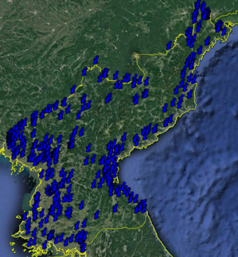
The project has located 11,661 extant monuments in North Korea. There's 13,566 military sites (manned, unmanned, and former). And there's 39,407 domestic sites marked. This represents a 18.1% increase from the 2017 map; however, the military folder is actually over 41% larger than the 2017 military folder. That's 64,634 sites.


The provincial breakdown for the monuments is:


In 2019 I published an initial survey of the country's monuments. The total figures have grown slightly since then, but the article also talks about other monument-related things and is worth checking out.

Compared to 2017, thanks to improved imagery and new construction, there are 1,765 more monuments located. The Pro version also includes the dates many were constructed, and from that we can now know that at least 623 monuments, murals, and bronze statues have been installed under Kim Jong Un. 

There are also three sites in Pyongyang that are prepared for future statues, but the statues have not been erected yet. 


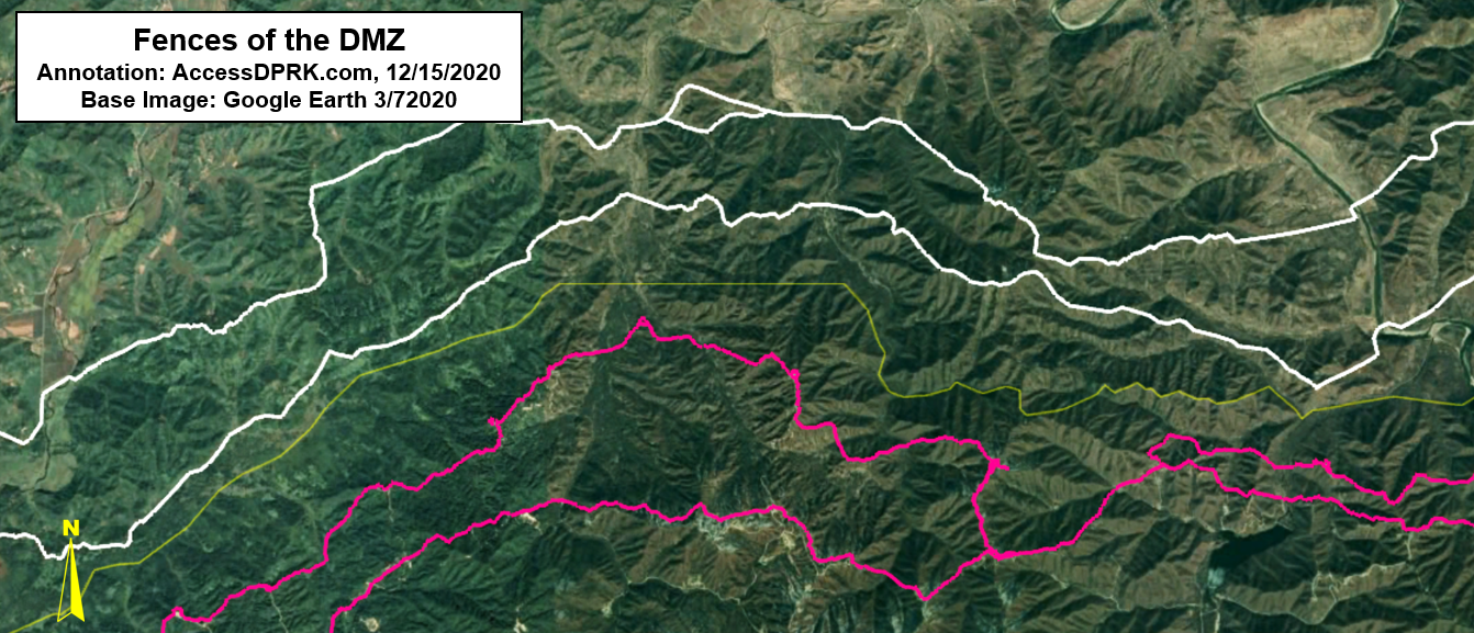
The military folder of the 2021 Pro Map is over 41% larger than the 2017 military folder. This isn't because I missed a bunch of places, but it's due to the fact that I wanted to give an even more granular look at the country's military, trends, and changes over time. This means I focused on mapping even former facilities, located the storage sites within military bases, paid special attention to locating tunnels and underground sites that may have been well hidden, and marked important bases (like missile sites) with greater detail. The change is also due to improvements in available imagery, making it possible to discover things that were previously too blurry to be identifiable. 

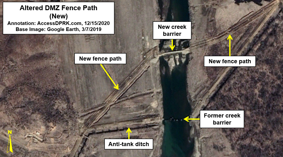
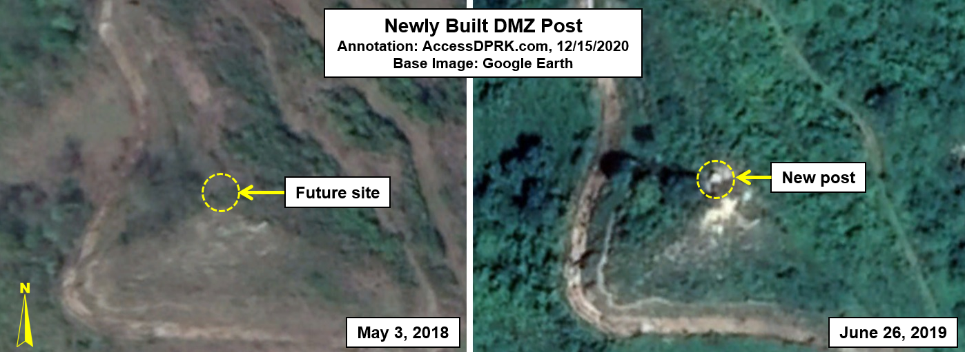
A few of the specific improved numbers are: 110 additional observation posts along the DMZ (at least 18 were built after 2015), 44 additional radar facilities, 67 more AAA sites (15 were built from 2015-2019), and over 400 additional verified military bases. Then there's the 126 hardened artillery sites that have been constructed since 2010. However, one of the largest increases comes from the storage facilities (stand-alone and within other bases) that I gave more attention to for 2021. The map includes 1,337 of them. That's a further 650 sites compared to 2017.

Since I have also tried to locate former artillery sites (so that other maps can be updated) and additional decommissioned bases to help researchers understand military infrastructure trends, I think it's important to say that of the 13,566 military-related sites, only about 900 (or 6.6%) are not part of the country's active defense. That means there's roughly 12,666 currently used sites (everything from missile bases to static, anti-invasion road blocks to tunnel groups and DMZ posts).


A notable change between 2017 and 2021 is the fact that there are 314 fewer propaganda signs marked. This is because many of them are simple wooden signs or chalk outlines on hillsides. Over time they fall down or are washed away. 

The demolition or other removal of sites, plus the fact that I did not include two 2017 categories (mountain peaks and Pyongyang bridges), means that the gross difference between the two maps is actually closer to 21-22%, and that the 2021 Pro map has ~11,600 entirely new places vs. 2017.

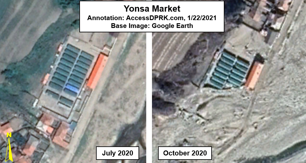
Some other changes worth noting is that there are 320 additional dams and hydroelectric sites marked, 71 additional markets, 371 more border posts (reflecting Kim Jong Un's efforts over the years to end defections), and there's the places that can only be found in the Pro Version. These include 149 gas stations (a growing trend in the country), the locations of 320 likely Railway Security Bureau facilities, and a national map of the country's lighthouses (some of which were only built in recent years).


Notes:

I want to add a few notes to help with context and prevent any confusion.

While most of the categories are indeed individual sites (there are 1,485 distinct electrical substations for example), some of the categories include not just the primary location but also sites within those places. A great example of this is that there are not 412 prisons in the country. There's 53 known, suspected, and former prisons that I was able to locate. And many of those prisons include detailed maps that also mark where the guard huts are, where prisoner housing is, and so on. So, one prison may be represented by 20+ items, and that's how I get to 412 total sites within the prison category.

The categories that have these more detailed folders are: prisons, missile bases, some historic sites, several of the "elite compounds", and a few factories. Additionally, some of the "province only sites" include multiple sites per place. This is especially true in Pyongyang which has the most of these province-only sites. An example is the Ryongsong Residence, which located within the "province only" folder, but that one residence includes 47 detailed sites within its folder. So, while there are 681 markers within the whole "province only" category, they're only representing around 275 primary places as several of those primary places have numerous sites marked within.

Lastly, in some cases I did not try to map every single one of the sites within a category. There are notes in the respective folders saying this, but they are: irrigation pumping stations, water supply, factories, agricultural sites, internal security checkpoints, parks, and gates. I tried to map a majority of sites and all of the important ones with the exception of the water supply sites, agricultural sites, internal checkpoints, and gates. For those, I wanted to give a representative sample and to locate major places. I only marked gates in cases where a facility was large and the main entrance could be difficult to find, and in cases where the gate itself was interesting/large.


I would like to thank my current Patreon supporters: Amanda O., GreatPoppo, Joel Parish, John Pike, Kbechs87, Planefag, and Russ Johnson.

--Jacob Bogle, 3/27/2021

Sunday, March 7, 2021

Is Wonsan Prison No. 88 Closing?

Located near the city of Wonsan, in the village of Sokhyol-ri, is a small reeducation prison camp (39.158666° 127.363326°). 

Reeducation camps (Kyo-hwa-so) are different from the major concentration camps (Kwa-li-so) most are aware of. These are smaller prisons that use forced labor to "correct" the thoughts of the prisoners and instill in them greater love and respect for the state. Through their labor they are remade into "good citizens". However, these prisons aren't like the ones found in America or elsewhere where prisoners make car license plates for nominal pay or a chance at an early release.

Prisoners can be required to work 18 hours a day doing hard labor and being beaten by their guards. All while being fed only a subsistence diet. There's no check waiting at the end of their sentence and they often experience lifelong disabilities. This is undoubtedly true at Sokhyol-ri (Kyo-hwa-so No. 88) because the prison provides the workforce for a nearby quarry. 

The public became aware of Kyo-hwa-so No. 88 in 2011 through the Database Center for North Korea Human Rights (NKDB) publication Prisoners in North Korea. While the camp has since been mentioned by other organizations, there remains very little public information about the prison. However, a review of Landsat imagery shows that it has been in operation since at least 1985. And, unlike many smaller prisons that were closed down throughout the 1980s and 1990sKyo-hwa-so No. 88 was kept operational. 

There are no prisoner testimonies directly from Kyo-hwa-so No. 88, but the quarrying site was identified as the prison by the Committee for Human Rights in North Korea (HRNK) in the 2017 Parallel Gulag report, as its layout fits with known prison designs in the country.

In 2012 the active quarry site was about 6,500 sq. meters in size. By 2020 it had grown substantially. The largest quarry expansion corresponds with the changes to the prison complex from 2017 and 2019. Based on its maximum size, I estimate that the prison population is between 1,000-1,500.

There is a small walled building 180 meters to the east of the main prison that was constructed in 2007. The compound encloses 2,020 sq. meters. I do not know if this is a prison annex or has another purpose.


Layout of Kyo-hwa-so No. 88 in 2009 before any demolition or closure.

From the above Google Earth image, one can see the layout of the prison as it was at its height. A perimeter wall surrounded part of the quarry and the workshops and housing are fully encircled by walls. The eastern part of the prison complex (the area behind the quarry) does not need any substantial security as the quarry itself provides a wall of stone, enabling that portion of the prison to be protected by a handful of guards. The explosives area has its own fence and a security hut (added in 2012), ensuring that materials aren't stolen.

In 2009, the prison and quarry complex occupied approximately 17.1 hectares.

The first major sign of change came in 2013, when the roof of the main workshop had been removed.

Image of Kyo-hwa-so No. 88 from April 20, 2013, showing the roof removal.

These kinds of changes aren't uncommon to see. Sometimes buildings are replaced or expanded. But as we will see, this was just the first large change to be seen at the prison as part of the facility appears to be undergoing a slow dismantlement. 

The next change comes in early 2016.

Kyo-hwa-so No. 88 as seen on Feb. 26, 2016.

By early 2016 the perimeter wall around the quarry had been removed; its debris still visible in this image. Additionally, the main workshop and another building had been fully demolished.

Three months later, the workshop section of the prison had been divided by a new wall and a new building was under construction.


A year later, in 2017, the newly created section was filled with new and remodeled buildings. 

The new center section has been filled with new buildings and the left-side section is no longer closed to the quarry.

The evolution of the workshop half of the original prison seems to suggest that it was divided into two segments to allow the far-left side to be open to the quarry as facilities for civilian use. I come to this conclusion by the lack of a quarry perimeter wall and the fact that the new center section is cut off from the left side by a new wall. The center section could still be part of the prison and used for forced-labor projects, but perhaps the quarry had been turned over to civilian control. 

Internal security agencies handing over mining and quarrying facilities to civilian authorities is not without precedent. It happened when Kwan-li-so No. 17 in Cholsan (a prison at an iron mine) was transferred out of police control ca. 1984-85. The now civilian iron mine is still operational.

However, this possible experimentation in having older prisons facilities used for civilian purposes while still having an active prison on the other side of the wall doesn't seem to have lasted long.

By November 2017, the structures in the new section were being demolished, part of the original prison wall now shows a gap, and another segment of wall had been removed.

The changes seen in late 2017 coincide with the completion of a large educational/sports related facility less than 250 meters away. This could mark the final transition of the prison being a forced-labor camp, to a more conventional detention center. Having large numbers of children and young adults driving by with a labor camp in clear view may have painted the wrong image for the regime. Of course, this is just speculation on my part.


Regardless of my speculation on the regime's reasons for the changes, subsequent observations make it very clear that half of the prison is being demolished and repurposed, and that the quarry is no longer part of a secured, prison complex.

Currently, the prisoner housing and administration area occupies ~6.48 hectares, while the quarry size has grown by 28% since 2007. 

Whether or not the prison has been fully decommissioned or merely decreased in size, with the quarry becoming a civilian site, is not confirmed. The urge to speculate is strong, but the only things that can be said for certain are what the satellite images show us. Not intentions, not the future. 

However, as I've said above, such changes have happened before. It could also be the case that the regime is in the process of realigning their prison system. Unfortunately, reports of recent amnesties followed by reports that Kim Jong Un is going to be expanding the prison system doesn't give us a clear answer. 

It is just as likely that Kyo-hwa-so No. 88 is changing its place in the system, from a forced labor camp to a local detention center according to the current needs of the state.

In any event, while the system remains dynamic, it is decades old and likely in need of substantial reform. Newer facilities, realignment of the major camps, and a more modern incarceration process would actually be beneficial from regime's standpoint in numerous ways. 

Regardless, even a partial closure of a prison usually means a partial release of prisoners (as others are transferred elsewhere). For those that may see their sentences ended, this change is only good news.


I would like to thank my current Patreon supporters: Amanda O., Anders O., GreatPoppo, Joel Parish, John Pike, Kbechs87, Planefag, and Russ Johnson.

--Jacob Bogle, 3/6/2021

Thursday, February 18, 2021

What Lies Beneath the Underground Republic

The internal workings of North Korea largely remain a secret to many in the world, and even Western intelligence agencies have bemoaned the relatively sparse amounts of information that flow out from the DPRK's borders. It's even suspected that the United States has no more than two or three low-level spies in the country - if there are any at all. This means that one of the main sources of information about this "hermit kingdom" comes from what can be gleaned through a vast array of satellites. 

One thing that becomes clear from these spies in the sky, is that North Korea has a fetish for digging.

During the Korean War, Kim Il Sung and his army witnessed the terrible and far-reaching ability of the Allied air forces to knock out military and economic targets from the sky. The northern part of the Korean Peninsula had been turned into Korea's industrial and most developed region by Japan during their 35 year occupation, but by the end of the three year Korean War, upwards of 85% of all buildings in North Korea had been completely or partially destroyed. The Korean War saw more tonnage of bombs dropped than in the whole of the Pacific Theater of WWII.

Kim Il Sung's expectation that Korean War II was imminent, and based on the lessons he learned during the first war, led to him commanding that the whole country be fortified, saying in 1963, "we must dig ourselves into the ground to protect ourselves"

The practical results of this are the countless miles of trenches along nearly every hill, a coastline ringed with artillery positions and anti-invasion obstacles, the second largest combined military and paramilitary force in the world, and lots and lots of tunnels, bunkers, underground factories, and other sites constructed beneath the surface and out of view. 


At this point, I want to sound a note of caution to those who like to let stories of North Korean mysteries run away with them. There has been plenty of speculation about the true extent of North Korea's underground infrastructure, with some going so far as to claim that most of their military bases are actually buried beneath the ground. The truth is, while both small and vast underground sites exist across the country, commercial satellite images do not support the idea that there's basically a parallel country underground. 

Military sites are easy to find if one knows what to look for and reviewing current and historic satellite images only reveal underground sites at some of them, and most of those are relatively small.  The only way you could claim that most bases have an underground facility (UGF) is if you include small storage bunkers or gun emplacements that are situated a few meters into a hillside. But I don't accept the definition of an "underground facility" as merely being "any usable structure with an inch of dirt on top". For the purposes of this article, UGFs are a sizable structure built into the ground, where the rock cover would provide meaningful protection from bombs and missiles.

Aside from military sites, major factories with UGFs are likewise easy to spot. I have looked at every square meter of the country more than once, and the 2021 AccessDPRK Pro Map is swollen with over 13,000 distinct military-related sites plus dozens of factories with an underground component. However, to reiterate, I haven't seen anything in commercial satellite imagery that convinces me there is a nationwide system of connected tunnels and underground sites.


Based on the AccessDPRK 2021 Map, Pro Version, the country has over 1,500 identifiable tunnels and underground facilities.

The sheer number of these sites overall is a little mind-boggling when you consider how relatively small North Korea is. The above map shows each of the 1,500+ tunnels and important underground facilities that I have managed to locate, as well as coastal batteries that have a clear underground component. It doesn't show the 850 hardened artillery sites, 492 drive-thru bunkers, or other installations that only have small access tunnels. The total number of large and small UGFs (which includes artillery sites and small storage areas) is estimated to reach as high as 14,000. 

Some sites were clearly constructed decades ago and were either abandoned or serve as emergency facilities in the event of open warfare. Because of this, their entrances have become overgrown with vegetation and that can make identification difficult. Furthermore, others have indeed been abandoned and mining operations or other domestic activities have encroached on the site; I saw little need to map those. 

There are also scores of stories about secret underground escape routes that connect Pyongyang and major palaces with underground rail lines that would allow the Kim family and top officials to be spirited away to the far north of the country, and even to China.

According to a 2015 report, the US military has mapped 6,000 to 8,000 of these "VIP" underground sites that North Korea's leadership could use to either hide or escape the country. The vast majority of them, however, would be simple bomb shelters (something that is common in South Korea, too). And, while this report lends credence to the idea of large, interconnected networks of underground facilities, the problem is that there is almost no direct visible evidence in the public sphere for such a massive system (although smaller tunnel segments have been identified). Additionally, this system is for the country's top leadership and isn't part of the normal domestic and military infrastructure of the country. So, this article is only going to focus on other underground infrastructure that plays a more "daily role" in the country.


While the exact purpose of each and every one of the sites is impossible to ascertain by simply looking at them from the air, most tend to fall into a handful of categories. There are a few major underground facilities, such as the Punggye-ri Nuclear Site, the Panghyon underground aircraft factory, and Kim's hardened helicopter base (which is part of a much larger underground command and control base). Most of the others can be classified into these: the underground factory or laboratory, the unspecified underground facility (many with protective berms at tunnel entrances), underground facilities at Navy and Air Force bases (excluding HARTS and storage bunkers), and basic tunnels (either individual tunnels or usually in groups of three).

The following set of images shows examples of various types of underground facilities. The satellite images used cover a large range of dates, but they were chosen because they best showed the sites in question.

Click on any image for an enlarged view.

The Hagap Facility in Chagang Province (40.081644° 126.189346°) is an example of a major underground site. Its exact purpose is unknown, but the two main theories are that it's either part of North Korea's nuclear program or a secured storage site for important government archives. Construction of the site has been ongoing for decades, punctuated by periods of inactivity, but since 2016, work has been steady.


Ryoho-ri Underground Naval Base (39.876051° 127.785328°)

This is a submarine base and the headquarters for the East Sea Fleet. It is one of 13 naval bases that have an underground or hardened facility. Ryoho-ri has two underground entrance points and suggests the existence of a large underground facility at least 300 meters in length and that could likely extend a further 150 meters into the hill. 

Ryoho-ri is so important that Kim Jong Il had a villa built nearby and both the villa and base have special rail access.


Pukchang Airbase (39.512137° 125.958563°)
Pukchang is one of 22 airbases and heliports that have associated underground facilities. I've already written about two of these in detail, the Sanghung-dong VIP Heliport in Pyongyang and the Kangda-ri Airbase near Wonsan. 

Pukchang is home to a Mig-23 fighter wing and has three main underground entrances into Obong Hill. It is also adjacent to the Yonggang-ni Helibase which has its own small UGF. 

Such facilities are used to store important aircraft and equipment, conduct maintenance, and at some airbases, even engage in manufacturing parts.


Tonghungsan Machine Plant (39.953611° 127.546918°)

Located in Hamhung, this is a major underground factory and is associated with North Korea's arms industry. Beginning in 2016, major reconstruction work began on both the underground portion and the external buildings. This reconstruction kicked off a series of new building and renovation projects at multiple arms facilities around the city including the Chemical Materials Institute and at the Hungnam Fertilizer Plant which produces chemicals used in various programs. 

Depending on Tonghungsan's exact size and layout, parts of the factory could be protected by over 150 meters of rock.


Taedonggang UGF near Pyongyang (39.174538° 125.946416°)
This is underground facility has a publicly unverified purpose. Located 6.5 km across from the Kangdong Residence on the other side of the Taedong River, it consists of four entrances divided into two sections. Tunnels 1 and 2 appear to be more for underground storage, while the size and configuration of the road and tunnels 3 and 4 suggest that they're for larger equipment (possibly TELs and MRLs).

Based on rough calculations of the volume of the spoil piles, there is at least 40,000 cubic meters of interior space for tunnels 3 and 4. That's the equivalent of a room 63x63 meters in size with 10-meter-high ceilings. The existence of a gantry crane and dedicated electrical substation can also clue us in to what purposes the site may be used for.


Pyongyang Armed Forces District UGF (39.059308° 125.733921°)
One of the largest identified underground facilities is beneath a hill in the middle of Pyongyang. One of the oldest entrance points is located at 39.059308° 125.733921° and is next to a secured villa. The tunnel can take VIPs into the facility that occupies a large portion of the hill or across the hill to the Sanghung-dong Heliport, where six helicopter hangars are protected by steel blast doors and hardened walls. 

Roughly 660 meters northeast from the original entry point is the newest entrance. It was added in 2017 and can take important people from an assembly hall directly into the UGF. 

This Armed Forces District UGF is one of multiple hardened command and control facilities within the city. 


While North Korea's engineers are capable of constructing large underground factories, they're still limited by the technology, education, and other factors that they have access to. North Korea is well known for their "speed campaigns" and for constructing large projects rapidly. Lack of enough materials due to sanctions and additional factors means that some of these projects end up shoddily built, with problems arising often and even occasional building collapses. These failures can also extend to military sites.

The following site is a coastal artillery position in North Hamgyong Province (41.896007° 129.950076°) that suffered a collapse, largely destroying the site.

Area before the collapse.


Area after the collapse.


North Korea built one of the deepest subway systems in the world, and they have a history of building underground facilities not only within their own borders but also around the globe. 

These places aren't just for hiding weapons or keeping the Kim family safe. Four massive tunnels that traversed the DMZ into South Korea are known about and some estimate that fifteen to twenty others could exist. Such infiltration tunnels could enable an invasion into South Korea with tens of thousands of soldiers and vast sums of equipment without warning.

From infiltration tunnels to escape routes 100 meters underground to new UGFs at ballistic missile bases, the difficulties in discovering this underground infrastructure and combating its ability to hide people and weapons present a continuing obstacle to intelligence. It may also provide a potentially unacceptable level of uncertainty regarding any offensive strike against the country by the United States or South Korea, as they may not know where each target person is exactly or if every nuclear bomb or technological site was hit. 


I would like to thank my current Patreon supporters: Amanda O., Anders O., GreatPoppo, Joel Parish, John Pike, Kbechs87, Planefag, and Russ Johnson.

--Jacob Bogle, 2/17/2021

Monday, February 1, 2021

AccessDPRK 2021 Map - Free Version

This image is an example of the domestic sites using the real icons in the map.

I started mapping North Korea in late 2012, released the first completed map in 2017, and began to remap the whole country in 2018. I wanted to keep track of changes, fix any old mistakes I came across, and to look for things that may have been missed during the initial phases of the project.

The combined result of roughly 7,000 hours of work is this 2021 free version. It contains over 61,000 places that are divided into three main categories: monuments, military, and domestic. Those are further broken down by province to give a more granular look at the country.

During the remapping process, I came across hundreds of places that had been mapped in 2017 but now no longer exist (mostly things like propaganda and town signs), so the true difference between the 2017 and 2021 versions comes to about an extra 8,500 places. Additionally, there were some categorization changes, new descriptions for hundreds of locations, and other changes. 

This Google Earth map is the most comprehensive look at the country freely available to the public. With some variation, there are 38-40 individual item categories in the domestic and economic section (everything from mining locations to irrigation pumping stations to factories and museums, schools and border security), and there are around 20 item categories in the military section. This has air defense sites, military bases, storage facilities, radar sites, etc. 

The monument's section is divided into Towers of Eternal Life and "others". Those include everything from murals to "On the Spot Guidance" memorials and everything else.

There is also a "nationwide" folder that is not divided into provinces but that holds all of the same type of place within single nationwide folders. The places in this section are: Historic Sites, DPRK Missile Bases, Prisons, Children's Traffic Parks, and Border Crossings (current and former). 

A note on the process of making this. As I have mentioned in previous blog posts, this project has been created by myself. I have no staff and no regular financial backing other than my great Patreon supporters. I have used what public information I could find in a reasonable amount of time (I can't read everything that comes out about the country), as well as my own experience to build this database.

I drew from older databases, books, government reports, western media, official North Korea media, think tank papers, conversations with knowledgeable people, and even sites like Wikipedia to help create it.

It is based on open-source information and geared toward English language readers. The Free and Pro versions have different levels of sourcing, but I almost exclusively stuck to English websites if I felt a location needed a link for reference. That means lots of places don't have links and many others don't need one at all.

For example, this is an anti-aircraft artillery battery. There is no need for some declassified document giving out the coordinates for this individual place. It is what it is, and there's around 1,500 of them.


As I said, not every place with a name will have a link. But for every place that does have a non-generic name, that name came from a source. Some of the locations were marked years ago, some were only marked within the last few months. Some online sources no longer exist, others have been archived. And other additional online sources may well exist, but if I don't know of them, I obviously can't add them.

I am not aware of any major, public database on North Korea that provides a citation for every single site (not even in cases when they're named and given other details). Sometimes the information comes from private discussions with defectors, other times it's drawn from old documentaries or DPRK media that no longer exists online (YouTube has conducted multiple purges of videos from official sources). In the process of creating this, I relied on established and trusted sources. 

If multiple sources say there's a missile base near Anbyon but with no specific coordinates, and I find a site with several indicators suggesting a site near Anbyon is a missile base, then that place will be marked as a potential missile base. If a building looks exactly like other known buildings, then it's going to get identified as that type of building (primary schools are a great example of this). 

This is a good faith, open-source project. Nothing more, nothing less. And out of over 61,000 places, errors probably exist. I do not guarantee that it is inerrant. Indeed, honest mistakes popup all the time, everywhere. I am trying to add to the world's available knowledge of the country and to seek the input and cooperation of others in filling in any holes or fixing mistakes. If you have any specific questions, feel free to ask.


Free Version Download & Operation

Here is the direct download link (version 1.1, 2023). The file is hosted via Google and is a little less than 5 MB in size. A new page will open and all you have to do is click the download button.

Simplified download screen. Yours may look different based on your browser.

If you're not familiar with Google Earth, it's pretty simple. Once you download the file, all you have to do is expand the menu (the little right-side arrows) to show the main sections. Pick one and expand it, decide which province you want to look at and expand that folder, and then pick the item(s) categories you're interested in. If you want to look at all of a particular site for the whole country, just click on each of the files within the various provinces.


Pro Version

If you're interested in the Pro Version, this page has a lot more information. In short, it contains nearly 9,100 additional places and over 3,000 other sites have extra bits of information such as links, construction dates, purposes and capacities, etc. 

For those interested in professional research or commercial/media interests, the Pro Version may be right for your needs.


Copyright Information

Aspects within the Free and Pro versions of the file may be subject to copyright and intellectual property rights enforcement under United States' law. No part of either version of the file may be used for commercial purposes without the express written permission of Jacob Bogle. This includes but is not limited to: use in contract bidding or fulfilling contracts for private or government interests; use in creating articles, films, maps, graphics, or other content for a profit-based entity; the creation of any map, dataset, or GIS product on a website or app that requires paid access to use that website or app. 


UPDATE: I have added an updated version, v1.1 (2023) in February 2023. It contains a number of changes to reflect provincial border adjustments, the addition of some new places, and corrected typos. The above download link is for the updated map. For more specific information, see here.


I would like to thank my current Patreon supporters for their continued support: Amanda O., Anders O., GreatPoppo, Joel Parish, John Pike, Kbechs87, Planefag, and Russ Johnson.

Sunday, January 24, 2021

The Yonsa City Tragedies

Flood damage in North Hwanghae Province, August 2020. KCTV

2020 brought three typhoons and massive flooding to North Korea. The combined effects of typhoons Bavi, Maysak, and Haishen destroyed large numbers of homes and thousands of hectares of farmland. The scale of the recovery efforts redirected labor and material away from large national projects like the Pyongyang General Hospital and the Tanchon Hydroelectric Project.

With a 2020 estimated population of 39,000, the city of Yonsa sits among the Hamgyong Mountain Range and is bisected by the Yonmyonsu River as it flows toward the Tumen River. This gives the city a beautiful natural landscape, but also places it at risk for floods.


In 2016 major flooding occurred along all of northern North Korea, affecting over 600,000 people and even damaged the important border cities of Hoeryong and Mansu.

  Yonsa in 2015.

Yonsa was one of the places affected by the flooding. The river spilled its banks and destroyed the stadium, damaged the earthen flood barriers that line the riverbanks within the town, and caused other damaged along its whole course (mostly flooding farmland). 

Prior to the flood, the Yonmyonsu River and its Kuunsu River tributary joined together at the terminus of a long peninsula. After the flood, that peninsula had been severed and became an island 1.58 km long and 100 acres in area. The confluence now happens at the southern end of the island instead of the northern point of the former peninsula.

Confluence of the rivers at the end of the peninsula, prior to the flood.

In response to the damage, the authorities used the event to rebuild large parts of the town and to build more modern apartment blocks. The new island was left detached, but work was done to shore up its defenses and rebuild destroyed properties.

The apartments were constructed in two sections of town. Twelve were built in the "downtown" area and on the northern end of town, on the east bank of the river, thirteen other apartment blocks were built. These, along with seventeen other multi-family homes were constructed where a large neighborhood once stood, comprised of scores of small one- and two-family dwellings. 

After the 2016 floods and recovery.

Several other apartments and homes were built up and down the river valley. On top of this, over 10 km of new and repaired flood barriers were built, including around the new island. Unfortunately, when their first major test came only three years later, they failed spectacularly. 

Comparison of the new island (outlined in blue). It was created after the 2016 flood and both rivers now partially join to the south. During the 2020 floods (right side), the island was almost completely covered by water, and debris and silt was left over most of it.

Fast-forward to the 2020 Typhoon Season. In rapid succession, the country got hit by the remains of typhoons Bavi, Maysak, and Haishen. Taking a page out of his grandfather's playbook, Kim Jong Un could be seen traveling the countryside and guiding rebuilding projects. 

Some of the damage to Yonsa included half of the marketplace getting washed away, the railway bridge was broken, the flood barriers built after 2016 were breached in multiple places, and 44 acres of a cooperative farm and forest management facility were flooded. Additionally, some of the apartment buildings constructed after the 2016 flood were close to having been washed away; their lower floors likely needing some repair.

Yonsa's marketplace before and after the 2020 flooding.

While Yonsa was one of the damaged cities, Kim didn't visit. Nonetheless, clean-up and rebuilding efforts began almost immediately.

On the Oct. 27, 2020 Google Earth image, four-five dozen family homes can be seen being constructed across the southern riverbank. More work has undoubtedly taken place since then. The question is, will the new work survive any better the next time it floods than before?

The city after the 2020 floods.

One bit of very good news is that despite two large flooding events, the Sinyang Dam 10.2 km upriver, never failed. If it had, the release of its 448-acre reservoir (at least 16.3 million gallons) could have destroyed far more of the town, plus all the small houses that line the riverbanks on the way to Yonsa.


Whether or not any storm or set of storms can be attributed directly to climate change is up for debate. What isn't debatable is that the long-term impact of a changing climate is more extreme and less predictable weather. If the three relatively mild storms (none were greater than Category 1 when they hit the country) can cause so much damage that it disrupts activities going on nationwide, North Korea needs to begin planning for even worse catastrophes in the future. 

In the meantime, Yonsa's small stadium has never been rebuilt.


I would like to thank my current Patreon supporters: Amanda O., Anders O., GreatPoppo, Joel Parish, John Pike, Kbechs87, Planefag, and Russ Johnson.

--Jacob Bogle, 1/23/2021
AccessDPRK.com
JacobBogle.com
Facebook.com/accessdprk
Twitter.com/JacobBogle

Saturday, January 2, 2021

AccessDPRK in 2020

This past year has been challenging for just about everyone in one way or another, but thanks to your continued readership and for the support of my Patreon supporters, the AccessDPRK project was able to carry on and have another good year.


Quick Overview

For 2020, I was able to write 24 articles for the project and discuss over 200 analyzed images on Twitter. The AccessDPRK site now has 121 published posts representing 759 pages worth of material. While the blog has been around since 2013, nearly 33% of all traffic to it has been from 2020. Traffic growth from 2019 to 2020 was up 81% as well.

Some social media stats include over 420,000 impressions on Twitter and the addition of 331 new followers. That's three times the number of gained followers in 2019. The project's Facebook page is also slowly growing.

This year's most read article was "North Korea's Underground Navy", closely followed by "Wollo-ri: Much Ado About Something". The article on underground naval facilities also caught the attention of media and was discussed in the International Business Times, Radio Free Asia, and others.

I was also able to make my contributing debuts to 38 North, Asia Times, and National Interest this year. 

Lastly, for the third year in a row, RAND Corp. used information from this project to help create one of their reports. For 2020, it was North Korean Conventional Artillery: A Means to Retaliate, Coerce, Deter, or Terrorize Populations


AccessDPRK 2021 Map

The biggest thing to happen since 2017 was that I completed the mapping process for the upcoming 2021 map. The map will be published in two versions, a Free version and a Pro version.

Over 400 ancient sites located within North Korea are available in the map.

The Free version will have over 60,000 places marked and will be the most comprehensive map of North Korea ever freely released to the general public. 

The Pro version (which will need to be purchased) will have over 1,500 additional sites including detailed maps of North Korea's missile bases and prison camps, hundreds of kilometers of former and new railway, suspected military bases, and more. There will also be a lot of added information throughout the file. I want it to serve as a kind of "one-stop shop" for English-language information relating to North Korea.

To accomplish this, there will be scores of links to relevant information from reputable think tanks, news organizations, NGOs, and others. Part of that task will also be the addition of links from AccessDPRK articles in the various placemarks. For example, the marker for KPA Farm No. 1116 will have a link to the AccessDPRK article about the farm, simplifying research. The same will be done for every mapped site that I have written about.

Related information from CSIS, Arms Control Wonk, 38 North, NK News, CNN, etc. will all be included where necessary. 

The Pro version will also have construction dates and other details added to well over a thousand other sites. Cell towers, dams, military bases, new housing developments, mines, etc. will have these extra bits of information when and where I can find them.

I am still considering pricing for the Pro version. I want to make it as accessible as possible, so I may offer the full version but also allow people to purchase item categories themselves. There are over 80 specific types of places mapped. If someone is only interested in the country's electrical grid, then it makes sense to let them purchase those individual files instead of having to buy the entire KMZ map.

I have some extra work left to do to split up the two versions, so I am not sure when I will officially publish the maps, but it will be no later than March. I'll make a separate post giving all of the details. 

Finally, I want to mention that Open Nuclear Network reached out to me a few months ago and was able to acquire an early copy of the full map. It's because of their interest that I was able to speed the process up considerably in completing the mapping portion of the project.


Looking to 2021

With the map basically finished and soon the be released, it's time to set new goals.

I already have a few smaller mapping projects in mind that will extend to things like geographic features as well as human structures, but I will mostly be focusing on mining the now completed database for new areas of research and new things to write about. 

There's also dozens of places of interest that I will continue to review, as well as keeping up with any new developments elsewhere in the country and news stories. There will definitely be continued posts on here as well as articles written for other sites.

Additionally, I plan to start branching out from North Korea and begin work on China and Iran. I won't be making giant maps like the one for North Korea, but they will cover various military infrastructure and important economic developments. While creating the DPRK map was largely a personal project of mine, I would be happy to work with others already working on Chinese and Iranian matters.

I can announce that the biggest single project for the foreseeable future will be: working on a book! I plan to take much of 2021 to research the book and do some initial work on it. That'll mean needing to buy lots of books, access journals, and digging into various archives. I've had the idea for a book for a few years, but I wanted to finish the primary mapping work before beginning the book work. 

I am going to keep the topic a little secret for now, but I will say that it is often brought up when writing about North Korea, but rarely do people go into detail about something that touches on so many aspects of the country.


Patreon

I set up a Patreon account in 2020 and have gained some great supporters. Currently, you can help support the project for $3, $5, $10, $15, and $20 monthly, each coming with their own rewards.

I am constantly thinking about new rewards to add, one of them being that I am working on a kind of virtual tour of the country. But you can already get early access to new articles, monthly digests, you can have me analyze places you're interested in, and get access to exclusive datasets. Plus, blog and Twitter mentions for any support at $3 or more.

If you believe in sharing facts-based information with the public about all aspects of North Korea (defense, culture, economy) as well as China and Iran (upcoming), please think about helping out. Every dollar really does help make this possible. 

With that, I want to give a huge THANK YOU to my current Patreon supporters: Amanda O., Anders O., GreatPoppo, Joel Parish, John Pike, Kbechs87, Planefag, Russ Johnson, and ZS.

And I want to wish everyone a wonderful upcoming year.  


--Jacob Bogle, 1/2/2021
AccessDPRK.com
JacobBogle.com
Facebook.com/accessdprk
Twitter.com/JacobBogle

Friday, December 18, 2020

The Ever-Changing DMZ

The Demilitarized Zone that separates the two Koreas is a bit of a misnomer. The super thin strip of land 4 km wide was created as part of the 1953 Armistice and aimed to keep both militaries apart and to create a safe, clear buffer zone. However, immediately on either side of the DMZ lies the bulk of both nation's armies.

"The Frontline". Image taken in 2012 by the Republic of Korea Armed Forces. Image source: Commons (CC BY-SA 2.0). 

And while the United Nations' stipulated boundary (on paper) hasn't really changed over the years, the physical boundary itself has (as defined as the fences both sides use). Indeed, the path of the electric fence that runs for 250 km across the peninsula has changed more than once, and the small guard huts are constantly being built, torn down, relocated, and then moved again. 

The effective border between the two countries is a line drawn in the center of the DMZ called the Military Demarcation Line. On each side of that is a narrow "no-man's land", penned in by the inner row of fences, and then a second line of fencing about half a kilometer from the first. This is supposed to create the 4 km-wide demilitarized zone, roughly 2 km on the north side of the MDL and 2 km on the southern side. However, the actual real-world width can vary considerably as both sides have tried to take advantage of the hilly terrain. In some places from the second line fence in North Korea to the second line fence in South Korea, the distance is 3.5 km, while in other spots it's nearly 6 km. 

Fences of the DMZ. The central yellow line is the Military Demarcation Line. The "practical" DMZ is bounded by the northernmost and southernmost fences. (South Korean fence paths, in pink, kindly provided by Javier Rives.)

This variation in the "practical" DMZ has led me to use a line that's roughly 4 km from the MDL to serve as the DMZ zone of immediacy. This isn't the 4 km of official DMZ width, but 4 km starting at the MDL and moving north into North Korea. 

The zone of immediacy not only includes the truly demilitarized no-man's land, but also the rows of guard towers (which are manned by soldiers), and numerous artillery and other military positions that form the country's first line of defense as a clearly connected set of military sites that stand apart from other defensive lines farther inland. It is within the DMZ-proper and the zone of immediacy that this article covers.


CHANGES TO DMZ FENCES

While the demarcation line doesn't change and the official layout of the DMZ doesn't either, the practical boundaries are created by two rows of electrified fences. The fences are guarded by hundreds of observation posts and even have machine gun nests constructed along the entire length of the DMZ; roughly one every 60-100 meters. Of course, those positions aren't manned and would only be used during a conflict.

Over the decades, the fence positions have been modified to take better advantage of the terrain and to allow for the best defensive posture while needing the fewest resources. One of the most recent examples of this is a 660-meter stretch at 38.065069° 126.847214°. It was built in late 2018-early 2019 and adjusts the fence's path slightly to the north. The original anti-tank ditch still exists but the old fence has been removed.


An example of a planned change that was never carried out can be found at 38.355133° 127.592494°. Sometime prior to 2007, the regime cleared a path 1.3 km long and ~12 meters wide along a hillside. They also dug machine gun emplacements. However, they never completed the new fence, and today the original fence remains while the 2007 path and emplacements sit largely unused; although, it does appear to have been kept clear of new brush growth.


One of the largest changes in recent years actually lies at the end of the official DMZ and at the beginning of the Northern Limit Line, the maritime boundary between the two countries. The DMZ itself ends south of Kaesong, as the Han River and its estuary form a natural boundary. But both sides have those coastlines heavily fortified as well, and the double line fencing system carries on for another 53 km, until it reaches the Ryesong River. 

That fencing originally ended at a pier on the river at 37.925110° 126.393169°. Around 2013, however, the regime extended one line of fencing up the river for a further 3.4 km. It now ends at a small mining village located at 37.952588° 126.392990°. The rest of the country's coast is fenced off as part of an anti-migration barrier.


CHANGES TO OBSERVATION POSTS

Cropped photo of North Korean DMZ guard post as seen from a South Korean post. Image: AP/Ahn Young-joon.

In 2018, North and South Korea demolished ten guard posts each on their respective sides of the DMZ as a show of good faith during a period of diplomacy. This was the first time such an action had been taken and it was met with widespread international praise. 

Unfortunately, as has happened for decades, each time the two sides try to work together, the diplomatic efforts quickly wane and grand schemes for cooperation and peace fade as new cycles of provocation begins again. 

While the destruction of the posts may have been the most public demonstration of guard posts changing (either being removed or built), it happens fairly regularly as part of routine DMZ "maintenance," as each side finds better spots to place new posts, removes redundant ones, etc.

In the 2021 version of the AccessDPRK map, I was able to locate 544 stand-alone observation posts along the DPRK side of the DMZ. These small positions are usually manned by 2-3 soldiers, keeping an eye out for any unusual activity coming from the other side and to stay alert for any North Korean soldiers attempting to cross and defect. At least 18 new posts have been constructed since 2015, including at least four that were constructed during or after the joint demolition of guard posts in 2018.

Examples of this newer construction is a guard post that was built in 2018 at 38.344391° 127.593518° and one that was built in 2019 at 38.323211° 127.461832° (pictured below).


HARDENED ARTILLERY SITES (HARTS)

By some estimates, North Korea keeps 60% of its artillery deployed within 100 km of the DMZ. But over the years, the disposition of that artillery has changed. Their deployments, types, and numbers have all varied over time. Of particular concern is their hardened artillery sites (HARTS). 

These medium and long-range artillery positions are very often hidden behind hills or are otherwise obscured from direct line-of-sight (known as defilade) and can hold some of North Korea's largest artillery systems, including self-propelled guns and multiple rocket launchers (MLRs). 

Within 100 km of the DMZ are at least 608 identified HARTS locations, each with multiple artillery pieces. (This figure agrees with the higher-end estimates noted in public sources). Between 2009 and 2017, 126 new locations were constructed, representing 20.7% of all HARTS in the region. 

Almost all of these new sites are within 10 km of the Military Demarcation Line and several are within the zone of immediacy. 

Map of new HARTS positions (2009-2017).

Roughly constructed in 9-10 groups, these HARTS were built to hold self-propelled artillery like the Koksan and 122 mm, 130 mm, and 152 mm systems. One of the most talked about weapons is the Koksan (M-1978) 170mm self-propelled gun. These have a maximum firing range of 60 km. 

The group of positions to the far west of the image is predominately MLRs constructed after the 2010 bombardment of the South Korean island of Yeonpyeong. They are large enough to accommodate the North Korean variant of the Soviet 122 mm BM-21 Grad multiple rocket launcher, which was suspected to have been used during the bombardment.

The rest of the new HARTS sites appear to be for other towed and self-propelled artillery systems.


The above image shows five individual gun emplacements constructed together as part of a single battery. There are a total of three batteries in the immediate area. These three batteries hold 16 guns combined. Fired in a volley, they could launch as many as 560 rounds every five minutes.

You can also notice that they were built as close to the DMZ as feasible to maximize the amount of effective range within South Korean territory. Other HARTS have been constructed farther inland over the decades to serve as a second-line defense in the event of an invasion. These, however, are very much intended as offensive positions to threaten Seoul and ROK soldiers stationed along the DMZ.


According to RAND Corp., a single barrage along the entire length of the DMZ of all artillery pieces (not just the newest HARTS batteries) could fire as many as 385,000 rounds in an hour and kill over 205,000 people.

Due to the overlapping nature of each artillery piece, the following map shows the areas held most at risk by the greatest number of new guns, with some areas being within range of over 30 distinct batteries (each with 4-6 individual artillery pieces).

This map shows the areas under threat from the highest number of new HARTS. The black wedge is also under great threat but lies at the far-end of the artillery's range, meaning fewer shells would likely reach the spot than those in yellow due to the high failure rate of North Korean artillery shells.

Downtown Seoul is in range of at least 30 new batteries but the area just to the north is within range of 47, which is why most of Seoul is not highlighted on the density map.


FINAL THOUGHTS

Other changes occur within and around the DMZ as well, though not necessarily as important as the ones described above. Many places within the DMZ (on both Northern and Southern sides) are routinely burnt to get rid of underbrush and create optimal observation conditions. What environmental impact this burning has on what has become an "accidental wildlife paradise", is little known. This also leads to increase erosion and will speed up the natural change in topography over time.

What began with the intention of being a temporary border has turned into a permanent feature of Korean division that has spanned three generations. The DMZ and the area around it have shaped the lives and destinies of millions and has become a sort of distant backdrop on which their lives play out, but it is certainly not a static feature. Lives are still lost and hopes are raised on this backdrop, but for as long as the peninsula is divided, it will stubbornly remain a symbol and a threat; one that can drastically change with the ebbs and flows of inter-Korean relations.


I would like to thank my current Patreon supporters: Amanda O., Anders O., GreatPoppo, John Pike, Kbechs87, Planefag, and Russ Johnson.

--Jacob Bogle, 12/17/2020
AccessDPRK.com
JacobBogle.com
Facebook.com/accessdprk
Twitter.com/JacobBogle